U.S. Department of Transportation
Federal Highway Administration
1200 New Jersey Avenue, SE
Washington, DC 20590
202-366-4000
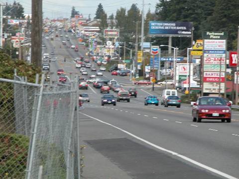
State Route (SR) 99 is a major urban arterial in Seattle and surrounding communities. One of its functions is to provide regional mobility. It is an alternative, high-capacity route to Interstate 5 and serves major regional destinations, including the Seattle-Tacoma International Airport. Traffic volumes are high along the entire corridor. In SeaTac, for example, average daily traffic is 38,000 vpd.
For the cities and towns in the Seattle area through which SR 99 passes, the highway serves additional functions. It is considered a "Main Street" and gateway by the communities that provides access to local businesses, residential areas, and bus transit along the highway, and creates an impression for drivers entering the communities.
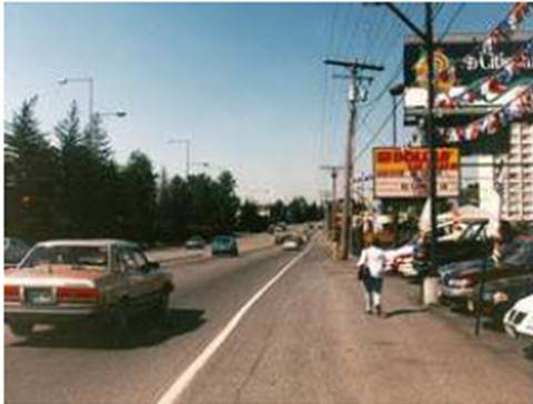
The existing highway consisted primarily of a five-lane cross section with two-way left-turn lanes (TWLTLs) (Figure 98). In many areas, strip-commercial development was the predominant land use adjacent to the highway. Sidewalks and other pedestrian accommodations were limited, and a lack of access control along the highway contributed to safety and operational problems. Posted speeds in the areas of reconstruction were 40 or 45 mi/hr, with slightly higher operating speeds in some areas.
Improving safety for both pedestrians and motorized users was a major impetus for the reconstruction projects along SR 99. When compared with highways of similar functional classification, SR 99 had some of the highest crash rates in the State. Crash severities were also high.
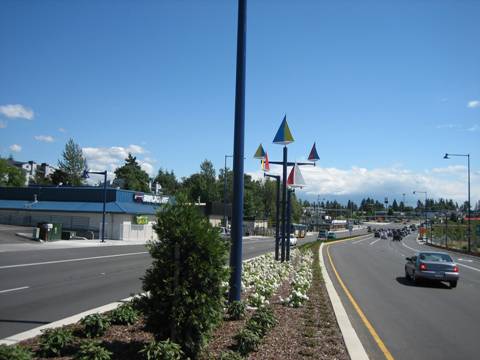
Beginning in the 1990s, several cities along SR 99 developed comprehensive plans for the corridor that proposed reconstructing the highway and redeveloping adjacent land. The goal of these plans was to develop a corridor that would enhance the area economically, improve safety, and create a more pleasant and attractive "Main Street" through their communities. The fundamental vision for SR 99 was to transform the wide, asphalt cross section with uncontrolled access and limited pedestrian facilities (Figure 99) into a tree-lined boulevard that would provide a safe, welcoming, and attractive environment for both pedestrians and drivers (Figure 100).
At the same time, there was a consensus that the highway’s important function as a major arterial for providing regional mobility had to be maintained. With the highway’s multiple functions, a cooperative relationship between the communities and Washington DOT was critical for resolving complex trade-offs and finding the proper balance between regional mobility and local goals..
|
SR 99 BEFORE Reconstruction in Des Moines |
|
|
|
SR 99 AFTER reconstruction in Des Moines |
|
|
|
FIGURE 98 SR 99 before (top photo) and after (bottom photo) reconstruction in Des Moines. The five-lane cross section with a two-way left-turn lane was common throughout the corridor. |
Figure 98 consists of two photos showing the before-and-after conditions of SR 99. The top (before) photo shows a five-lane cross section with a two-way left-turn lane in the center. The bottom (after) photo shows a new landscaped median in place of the two-way left-turn lane.
|
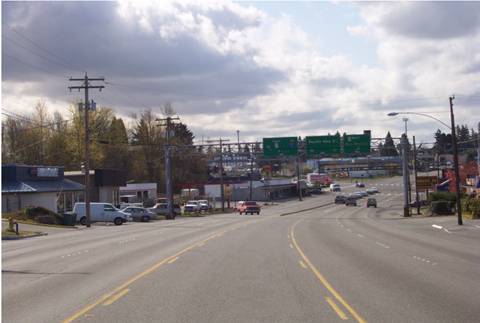
SR 99 BEFORE Reconstruction in SeaTac |
|
|
|
SR 99 BEFORE Reconstruction in Shoreline |
|
|
|
FIGURE 99 SR 99 before reconstruction in SeaTac (top photo) and Shoreline (bottom photo). Note the wide paved shoulders, lack of access control, and no sidewalks. One of the primary goals of the communities along the highway was to create a more attractive, pedestrian-friendly local environment. |
Figure 99 consists of two photos showing pre-construction conditions along SR 99 in the communities of SeaTac (top photo) and Shoreline (bottom photo). Both photos feature views of wide paved shoulders, the lack of sidewalks, and lack of access control along the road.