U.S. Department of Transportation
Federal Highway Administration
1200 New Jersey Avenue, SE
Washington, DC 20590
202-366-4000
Three million miles of local roads are maintained and operated by local administrators, township managers, and public works officials in more than 38,000 counties, cities, villages, towns, and tribal governments across the United States.1 One issue common to all local agencies is traffic safety.
One of the most pressing traffic safety issues on local roads is intersection safety. Intersections can vary widely in terms of size, shape, number of entering legs, and number of turn lanes. According to the American Association of State Highway and Transportation Officials' (AASHTO) A Policy on Geometric Design of Highways and Streets, an intersection is defined as the general area where two or more highways join or cross, including the roadway and roadside facilities for traffic movements within the area. Each highway radiating from an intersection and forming part of it is an intersection leg. The most common intersection where two highways cross has four legs. Intersections generally involve through- or cross-traffic movements and typically involve turning movements between the highways. There are three general types of highway crossings - at-grade intersections, grade separations without ramps, and interchanges. This document addresses safety issues related to at-grade intersections.
Local rural roads also encompass a wide range of surface types, including paved facilities, gravel roads, and dirt roads. Many local rural intersections lack suitable design standards, delineation, and signing that may be provided on higher volume roadways. Further, many were not officially designed, but rather "evolved" over time to their current geometric configuration.
In 2008 the National Highway Traffic Safety Administration (NHTSA) indicated that 56 percent of the 37,261 fatalities on U.S. roadways occurred in rural areas.2 This figure is disproportionate since only 23 percent of Americans live in rural areas3 and rural roadways account for just 40 percent all vehicle miles traveled nationally.4
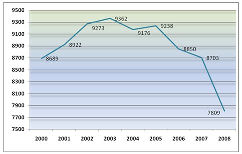
More than 20 percent of all traffic fatalities in the United States occur at intersections, both signalized and unsignalized. As shown in Figure 1, the number of intersection-related fatalities has been decreasing since 2005, yet the overall number is still very high.
More than 80 percent of rural intersection fatalities occur at unsignalized intersections. Due to this high proportion of crashes at these types of intersections, unsignalized intersections will be the focus of this report. For information on safety at signalized intersections, please refer to Signalized Intersections: Informational Guide5 and NCHRP Report 500, Volume 12, A Guide for Reducing Collisions at Signalized Intersections.6
Figure 1. Intersection Fatalities by Year
According to FHWA, the most severe crash type at unsignalized intersections is a right-angle crash. This crash type typically occurs when two vehicles approaching at a perpendicular angle collide due to one vehicle failing to stop or yield right of way from a Stop or Yield sign. In recent data analyses commissioned by the Federal Highway Administration (FHWA), every 100 reported angle crashes at unsignalized intersections resulted in approximately 1 to 3 fatalities and 5 to 15 serious injuries.7
FHWA recognized that while a number of States had intersection safety as an emphasis area in their Strategic Highway Safety Plans (SHSP), they lacked an action plan to guide their intersection safety implementation activities on State and local roads. To date, FHWA has worked with 11 States to develop Intersection Safety Implementation Plans (Arizona, Florida, Georgia, Indiana, Louisiana, Mississippi, Missouri, Ohio, Pennsylvania, South Carolina, and Tennessee).8 The plans include the activities, countermeasures, strategies, deployment levels, implementation steps, and estimate of funds necessary to achieve the intersection component of the State's SHSP goal. Local road practitioners should consult their State's Intersection Safety Implementation Plan, if available, before embarking on an improvement strategy.
Local practitioners should consider implementation methodology when seeking to address intersection safety within their jurisdiction. Typical approaches include:
For the systematic approach, the analysis is based on crash types and proven safety countermeasures selected based on those types.
In one application of the systematic approach, common crash types are selected from analysis. Locations experiencing these crash types and locations with similar geometric features as those experiencing selected crash types are selected and treated systematically with low-cost safety countermeasures.
Another application of the systematic approach begins with identifying low-cost, effective countermeasures to common traffic safety issues. Once a basic set of countermeasures is identified, the crash data system is analyzed to choose locations where the countermeasures can be cost-effectively deployed. Estimates of the impacts of implementation can be made in terms of deployment cost and the benefits measured in traffic crash reduction.
Benefits of the systematic approach may include:
Drawbacks of the systematic approach may include:
The spot location approach has typically been based exclusively on an analysis of crash history. Due to the fact that some locations in a jurisdiction may have a significantly higher number of crashes than most of the others, it is important to identify those locations and treat them accordingly.
The benefits to the spot location approach may include:
Drawbacks of the spot location approach may include:
The spot location approach to traffic safety can be implemented in parallel with the systematic approach to provide the best combination of safety treatments in a jurisdiction. In addition, the spot location approach could be applied to those locations that have had low-cost countermeasures installed systematically but, after an assessment, continue to show a higher than average crash rate.
The comprehensive approach introduces the concept of the 4 E's of Safety; Engineering, Enforcement, Education, and Emergency Medical Services. This approach recognizes that not all locations can be addressed solely by infrastructure improvements. Incorporating other elements is often required to achieve marked improvement in intersection safety.
Some intersections will be identified that have frequent driving violations for which targeted enforcement is an appropriate countermeasure. In general, the most common violations at intersections are speeding, failure-to-yield, aggressive driving, failure to wear safety belts, and driving while impaired. When locations are identified that have reports and observations of these violations, coordination with the appropriate law enforcement agencies is needed to deploy visible targeted enforcement at the identified intersections to reduce the potential for future driving violations and related crashes. Education and outreach efforts should supplement enforcement to improve the effect of each.
The purpose of this document is to provide information on effectively identifying intersection safety issues and countermeasures that address them, leading to the effective implementation of safety projects. This includes pertinent information regarding the Manual on Uniform Traffic Control Devices (MUTCD) requirements, guidance on conducting field reviews, identification of unsignalized intersections with multiple crashes and/or high potential for future crashes, selection of the appropriate low-cost improvement at these intersections, and evaluation of safety projects and processes.
This document is intended to provide appropriate intersection safety information in one report. Some practitioners responsible for the safety of the local road network may not have formal safety-specific highway training; this can present a challenge in reducing the risk of crashes at rural unsignalized intersections on local roads. In addition, the person responsible for highway safety may have multiple responsibilities including public works functions, such as water and/or wastewater treatment, trash collection, and snow removal. In these cases, roadway safety and infrastructure maintenance may be only a small part of the job.
The report is not intended as a comprehensive guide for intersection design and improvement. It does, however, provide a framework that can be used to assess the safety of existing intersections and determine whether additional countermeasures should be installed.
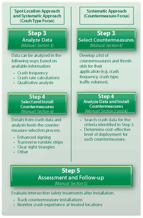
This document suggests a process for the planning and implementation of intersection safety improvements. The processes discussed in this document are summarized in Figure 2.
Figure 2. Steps to Address Intersection Safety
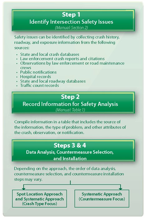
Section 2 of this manual provides an overview of the types of data to collect for the identification of intersection safety issues. It discusses the sources of crash data and how they can be used. Additionally, types of roadway data used in safety analyses are introduced.
Section 3 summarizes the types of analysis that can feed the issue identification and countermeasures selection process. This discussion builds on the types of information and data discussed in Section 2 and provides definitions and examples of the factors that should be considered.
Section 4 provides a description of selected countermeasures that have been shown to improve safety at unsignalized intersections on local rural roads. It includes a basic set of strategies - supplementary warning signs and pavement markings - to install at locations experiencing a history of crashes. The section also introduces additional safety strategies, including flashing beacons on Stop signs and turn lane modifications.
The steps to complete an evaluation are presented in Section 5. After the countermeasures are installed, assessing their effectiveness will provide valuable information and can help determine which countermeasures should continue to be installed on other intersections to make them safer as well.
In Section 6 a summary of the overall content of the manual is presented.
A list of resources and references is presented in Appendix A. It includes publications that focus on intersection countermeasures, research that supports their use, and various studies that document their effectiveness. The appendix also includes references that focus on the use of data-driven processes for countermeasure selection, assessment procedures and strategies, descriptions of successful programs, and national programs that may help identify resources to support local efforts.
Appendix B addresses compliance with MUTCD minimum requirements for rural unsignalized intersections. The MUTCD provides the standards used by road managers nationwide to install and maintain traffic control devices on all public streets, highways, bikeways, and private roads open to public traffic.
1 McNinch, T.L. and Colling, T.K. "Traffic Safety Education for Nonengineers." Public Roads, May/June, 2009, pp. 32-39. Available at: https://www.fhwa.dot.gov/publications/publicroads/09june/05.cfm [ Return to note 1. ]
2 National Highway Traffic Safety Administration, Traffic Safety Facts: 2008 Data (Washington, DC: 2009). Available at http://www-nrd.nhtsa.dot.gov/Pubs/811164.pdf [ Return to note 2. ]
3 U.S. Department of Transportation, "Rural Safety Initiative," web page, February 2008. Available at: http://www.dot.gov/affairs/ruralsafety/ruralsafetyinitiativeplan.htm [ Return to note 3. ]
4 U.C. Berkeley, Safe Transportation Research & Education Center, "Rural Road Safety" web page. Available at http://www.tsc.berkeley.edu/research/ruralroads.html [ Return to note 4. ]
5 Federal Highway Administration, "Signalized Intersections: Informational Guide," FHWA-HRT-04-091 (Washington, DC: August 2004). Available at https://www.fhwa.dot.gov/publications/research/safety/04091/ [ Return to note 5. ]
6 Antonucci, N. et al., A Guide for Reducing Collisions at Signalized Intersections, TRB, National Research Council, NCHRP Report 500, Vol. 12, 2004. Available at: http://onlinepubs.trb.org/onlinepubs/nchrp/nchrp_rpt_500v12.pdf [ Return to note 6. ]
7 Federal Highway Administration, "State Intersection Safety Implementation Plans," 2008-2010. (unpublished studies) [ Return to note 7. ]
8 An example Intersection Safety Implementation Plan is available at http://safety.fhwa.dot.gov/intersection/resources/sfty_imp_pln0709/#toc [ Return to note 8. ]
 You will need the Adobe Acrobat Reader to view the PDFs on this page.

