U.S. Department of Transportation
Federal Highway Administration
1200 New Jersey Avenue, SE
Washington, DC 20590
202-366-4000
| < Previous | Table of Con tents | Next > |
In Iowa, Regional Planning Affiliations (RPA) are key participants in the formation and ongoing success of Multidisciplinary Safety Teams (MDST). MDSTs are local safety teams that convene to coordinate local expertise, priorities, perspectives, and recommendations for safety improvements. Several of Iowa's 18 RPAs have MDSTs and the other RPAs have been encouraged to form MDSTs. This unique partnership with RPAs allows all cities and counties to benefit from the MDST initiatives. RPA staff play a key role in the teams by working with diverse groups to help them understand issues, helping stakeholders work together, providing input and experience on the long-range planning process, promoting transportation safety planning concepts, and providing access to and analysis of crash data.
MDST meetings are often hosted by the RPAs with initial assistance from Iowa DOT and the Institute for Transportation (InTrans) staff. Key objectives can vary by region, depending on goals and most pressing issues but objectives almost always include the identification of potential safety projects and programs. Meeting activities include facilitated discussions on issues, crash analysis workshops, construction zone management, safety audits, safety corridor evaluation, local media and marketing campaign efforts, and other multimodal planning topics. Ultimately, all applicable activities are incorporated into the RPA planning and programming process.
The MDSTs have helped RPAs successfully integrate safety into their planning processes and provide invaluable multidisciplinary input for planning and programming safety improvement projects and implementing safety programs. This approach incorporates local safety issues into the process and helps Iowa DOT work to reduce fatal and serious injuries (nearly 50 percent of all fatal and serious injury crashes occur on local roads in Iowa).
In general, safety activities have been an integral part of the planning activities at Iowa's 27 RPAs and MPOs.
The Vermont Highway Safety Alliance partners with Vermont's regional planning commissions to host Regional Highway Safety Forums (the oversight and development of the Strategic Highway Safety Plan is accomplished through the Vermont Highway Safety Alliance which consists of the Executive Committee, the Board, and five Focus Teams). The purpose of the safety forums were to establish relationships between regional safety stakeholders, begin discussions on sharing resources, and identify highway safety issues specific to each region. Key participants at each forum included local and regional law enforcement, emergency management services, fire departments, planners, engineers, driver's education professionals, and other highway traffic safety stakeholders in the region.
Forum participants are introduced to the Vermont Strategic Highway Safety Plan, statewide safety initiatives, and the local roads program. Sessions on topics in engineering, education, enforcement, and emergency services are offered to educate participants on Vermont's seven critical SHSP emphasis areas. VTrans shared information on data available to the local agencies for decision-making. An afternoon breakout session included a discussion exploring regional data provided by VTrans. Participants were expected to discuss any data commonalities, local groups or personnel to be mobilized to address issues, outside sources that can be leveraged to assist, and strategies to consider for next steps.
The Regional Highway Safety Forums served as an opportunity to engage a larger group of partners in the SHSP process and to personalize the experience for local agencies. The initiative gives local agencies better access to crash data, more knowledge of funding for safety programs, and better understanding of statewide safety initiatives.
Figure A.1a Vermont Highway Safety Forum Registration Flyer
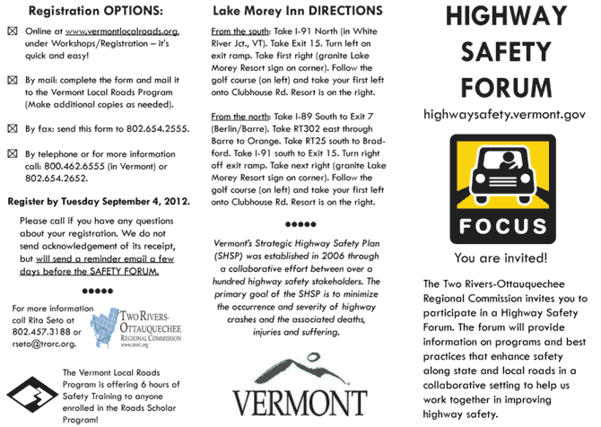
Source: Two Rivers-Ottauquechee Regional Commission.
Figure A.1b Vermont Highway Safety Forum Registration Flyer (continued)
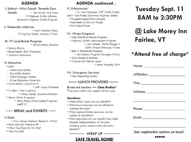
Source: Two Rivers-Ottauquechee Regional Commission.
Virginia DOT has developed a process for ranking and prioritizing projects in rural regions served by the State's Planning District Commissions. The process is used to rank all rural LRTP projects based on performance measures. The Lynchburg District LRTP project selection and prioritization process, as an example, is available on the Region 2000 web site. Transportation projects were selected for the LRTP based on the following criteria: safety, operations and maintenance, and capacity. The prioritization process involves using key roadway attributes, based on the five transportation goals of the VTrans 2035 Plan to calculate a weighted score for each project. Data was collected from the Statewide Planning System, VDOT's on-line GIS tool and VDOT's Traffic Management System (TMS). The goal of the project was to rank each LRTP project for each county in the Lynchburg District based on a series of weighted technical road attributes. A detailed prioritization matrix was used to score and rank each project based on the roadway characteristics outlined in Table A.1.
Table A.1 Weighted Transportation Attributes Used for Ranking Recommended Projects in the Prioritization Matrix
| Roadway Element/Attribute | Description | Weight Relative to Prioritization Goals |
|---|---|---|
| Proposed Number of Lanes | Number of recommended lanes from transportation plans that propose additional lanes, if applicable. | N/A |
| Length of Project | Total length in miles of the proposed recommendation. Intersection recommendations receive a default value of 0.5 miles. | N/A |
| 2009 Level of Service | Measure used to determine the effectiveness and operational level of the roadway in 2009. | 33% |
| 2009 V/C Ratio | Volume-to-Capacity Ratio is an index to assess traffic conditions and level of congestion of the roadway. | 33% |
| 2011 AADT | 2011 Average Annual Daily Traffic is the total volume of vehicle traffic on a roadway for 1 year divided by 365 days. | N/A |
| 2035 AADT | Projected 2035 Average Annual Daily Traffic rates. | N/A |
| Flow Rate (pcphpl) | The maximum rate of flow reasonably expected on an existing roadway while maintaining a certain LOS in passenger cars per hour per lane. | 33% |
| Fatal+Injury Crash Rate per Mile (2006 to 2010) | Total number of aggregate injuries and fatalities on the roadway per mile from 2006 to 2010. | 100% |
| Number of Heavy Trucks | Total number of heavy trucks in 2011 on a select roadway segment which equates to the estimated percent heavy trucks. | 50% |
| Cultural Resources | Total number of historic properties and cultural resources in close proximity to the right-of-way of a select roadway. | N/A |
| T&E Species | Threatened and Endangered Species considerations. | 50% |
| R/W Impact | Any impacts on the right-of-way considered here (such as environmental or social). | 50% |
| Include HOV, Bike/Ped, other Modes | Any special accommodation features for HOV, bicycle, pedestrian, or transit are considered here. | 25% |
| Structurally Deficient Bridge (square feet) | Total square footage of a structurally deficient bridge from the 2035 Rural LRTP. | 25% |
| Total Cost | Estimated cost of the recommended project from the 2035 Rural LRTP. | 25% |
Source: Virginia Department of Transportation, Project Prioritization Process and Methodology 2013 Update.
Developing a prioritization process and ranking for road improvement projects have several benefits:
The North Central Pennsylvania RPDC developed a Regional Safety Study to evaluate the safety-related issues along the Core Roadway System in their region. The Core Roadway System connects the region's most important economic centers and the transportation facilities and businesses that serve them. The study examined existing and historic information related to highway safety, including crash data, characteristics of the roadways and input on motorist, pedestrian, transit, and bicyclist safety from the public and project stakeholders. Roadway safety related to economic development and important connections to air and rail transportation were also evaluated. The region's transit agencies were included as part of the study to determine roadway safety conditions relative to public transportation and to identify resultant mobility, accessibility, and safety improvements.
The corridor safety analysis was conducted to determine which areas presented the greatest safety concern in the region. Data collected from PennDOT Crash Reporting System (CDART), North Central Pennsylvania RPDC Top 25 Crash Locations List, Pennsylvania DOT's Top 20 Intersection Safety Concern List, and input from local officials and stakeholders was used to inform the site selection identification process. This list of sites was prioritized or ranked using qualitative and quantitative (benefit-cost analysis) methods that evaluated the improvement's effectiveness. The goal was to develop a final list that reflected priorities of the stakeholders and the public while taking economic factors into account. A comprehensive list of proposed safety improvements was developed and included both project-specific improvements and systematic improvements. The proposed safety improvements were integrated into PennDOT's highway planning process with the development and submission of Linking Planning and NEPA (LPN) Level I Screening Forms. The plan also identified the proper funding source for each proposed site improvement.
For additional information, see the North Central Regional Safety Study.
You may need Adobe® Reader® to view the PDFs on this page.
| < Previous | Table of Contents | Next > |

