U.S. Department of Transportation
Federal Highway Administration
1200 New Jersey Avenue, SE
Washington, DC 20590
202-366-4000
Sign up to have Safety Compass delivered right to your inbox!
Best for printing: PDF Version (1.08 MB)
In this issue:
A Message from the FHWA Associate Administrator for Safety, Beth Alicandri
Join Us on an HSIP National Scan Tour!
NE Transportation Safety Conference Leads to Successful Peer Exchange
FHWA Promotes Data-Driven Safety Analysis in Project Development Peer Exchanges
Hot Off the Press! Safety Publications Portfolio
Road Diets–Safer Roads, Safer Communities
2016 Grant Recipients for Accelerated Safety Activities Program (ASAP) Projects Announced!
The Roadway Safety Data Program Toolbox – What's New?
Addressing Motorcycle Safety through Road Safety Audits
Wanted: New Statistical Methodologies to Support Vulnerable Road User Safety Research
Connected Vehicles May Offer Important Benefits to Vulnerable Road Users
FHWA Supports World Road Association in Launching New Road Safety Manual
New Resources Support State Implementation of the Safety PM Measures Final Rule!
Making Local Roads Safe and Secure: A County Priority
Missouri Coalition for Roadway Safety Receives APWA Exceptional Performance Award for Safety
University of Maryland Successfully Integrates Multiple Data Sources to Help Save Lives

I am pleased and honored to write to you as the new Associate Administrator for Safety, and I look forward to working with all of you to overcome the challenges we face in reaching our common goal of zero deaths on our Nation's roads.
Tragically, the recent release of the 2015 fatality data indicates a 7.2 percent increase in motor vehicle traffic deaths for the year; 35,092 people died in 2015, up from the 32,675 reported fatalities in 2014. While these numbers are disappointing, they should also make us more determined than ever to do whatever we can to ensure this is a temporary setback, not a new trend. Nobody should have to die just because they drove, biked, or walked somewhere.
We can make zero deaths a reality by recommitting ourselves to working with colleagues and stakeholders to explore and learn from their perspectives, expertise, and innovative approaches in order to make our roads safer. A recently completed Highway Safety Improvement Program scan tour did exactly that (see page 2), as did two successful peer exchanges the Office of Safety sponsored earlier this summer (see page 4 and page 6).
Engineering is the first E in the 4Es of transportation safety. We have extensive proof that when we engineer for zero deaths, fewer crashes occur and fewer deaths result. For example, a recent study of 93 U-turn type alternative intersections installed in North Carolina between 1997 and 2012 shows a 59 percent reduction in total crashes, a 71 percent reduction in fatal and injury crashes, an 88 percent reduction in fatal and severe injury crashes, and an 80 percent reduction in frontal impact crashes to date (see page 21).
The FHWA offers many forms of assistance to help reduce roadway fatalities, from experts who can provide technical assistance, to our extensive online tools and resources (see page 7 for the latest offerings), to the workshops and peer exchanges we offer on an array of topics. I encourage you to visit http://safety.fhwa.dot.gov and learn more about how you can leverage these tools to help you better engineer safety into your roadways.
By Karen Y. Scurry, FHWA Office of Safety
During the fall of 2015, FHWA led a national scan tour to learn more about various State Highway Safety Improvement Program (HSIP) implementation efforts. Joining me on the scan team were representatives from FHWA Division offices, State Departments of Transportation and our contractor support team. While FHWA establishes the requirements for HSIP under 23 CFR Part 924, each State develops and implements an HSIP that best meets its program's needs. This results in 51 different State HSIPs containing informative and innovative approaches to improving roadway safety. Therefore, as part of the scan tour, we visited a diverse group of States based on geographic location, number of roadway miles, distribution of roadway ownership, HSIP apportion-ments, and safety performance. So, join me on a trip across the country as I highlight some of the noteworthy practices we learned on the scan tour.
Our first stop was Utah, one of several States that participate in the Zero Fatalities program (http://ut.zerofatalities.com/). UDOT has undertaken a coordinated effort to send consistent messages related to Zero Fatalities. All public information campaigns are branded as a joint effort among the Zero Fatalities program partners to illustrate the cooperative atmosphere and are developed to address behavioral issues identified in the Strategic Highway Safety Plan (SHSP). In addition, the statewide crash database receives electronic input from all of Utah's police agencies. Utah DOT delivers its HSIP using several analysis tools: Numetric, FHWA Systemic Safety Project Selection Tool, usRAP, and the Utah Crash Prediction Model.
In Oregon, the HSIP is delivered through the All-Roads Transportation Safety Program (ARTS), which creates a jurisdictionally blind process for project nomination and selection. All public roads are included in the program regardless of agency ownership or responsibility. Funding is distributed to each region based on the number of fatalities and serious injury crashes. As part of the ARTS Program, ODOT developed a list of countermeasures, known as the ODOT Crash Reduction Factor (CRF) List, which will be revised as new countermeasures become available.

"...(U)sing the information that Oregon presented during the HSIP Scan Tour, I was able to convince TDOT to develop a CMF list using the CMF clearinghouse."
— Jessica Rich, FHWA TN Division
"It was encouraging and insightful to see how States are using the increasing quantity and quality of data to produce safety programs that target areas of greatest need and efficiently use limited resources. Although done differently in all States, the commitment to using crash data and the push to link this to all other data was helpful to hear."
— Rick Drumm, FHWA Indiana Division
Illinois was the only State on the scan tour to set aside HSIP funds (up to 20 percent) to support local road safety projects. In Illinois, all projects are subjected to the same criteria for evaluation by the Central Safety Committee, which meets annually to select projects for local roads and continuously reviews applications from the Districts for their projects.
IDOT uses several tools to help manage the HSIP–safety performance functions, safer roads index, and safety tiers. They use safety performance functions developed through the University of Illinois to perform network screening and identify those roadway segments and intersections with high potential for safety improvement. The IDOT Safer Roads Index improves the integration of quantitative safety performance in transportation project planning and programming. Safety Tiers categorizes roadways segments and intersections based on their level of safety performance and opportunity for improvement, providing a rating for relative comparison which allow transportation officials to understand relative performance of a location compared to similar types of roadways or intersections.
Massachusetts DOT (MassDOT) conducts a data-driven selection of candidate projects using the Crash Analysis Tool, which produces a clustered crash map using GIS tools and the geo-coded crash system. MassDOT uses the tool to generate the HSIP-eligible projects list (i.e., the "5% List"). MassDOT requires road safety audits (RSAs) for all HSIP projects as part of the Functional Design Report. RSAs are incorporated into the project development process for all projects that encompass 5% List locations and segments, even when not HSIP funded. MassDOT provides project funds for matching the HSIP contribution for local agency projects, eliminating the need for local agency matching funds, which many have noted as a major challenge in using Federal funds on local roads.
In New Hampshire, the HSIP staff is a part of the Design section and works with the State Traffic Engineer and the Highway Safety Engineer to plan, select, deliver, and evaluate projects with the help of an HSIP Committee. New Hampshire is nationally recognized for its efforts to use Safety Analyst software. NHDOT expended a multi-year effort on Safety Analyst development, particularly in the area of data management, data manipulation, and correlation with traditional methods using a phased approach. Network screening and multi-criteria screening methods ensure comprehensive examination of corridor, segment, and intersection performance. In New Hampshire, Safety Analyst has enabled the transition from observed crash evaluations to SPF-based evaluations and cost-per-countermeasure evaluations. Safety Analyst is also used by local planning organizations in the development of all transportation projects.
North Carolina was the final stop on our scan tour. NCDOT uses a safety warrants system for project screening, prioritization, and selection based on a benefit-to-cost ratio. The safety warrants system is used to identify locations that have a demonstrated need for safety improvements. This warrant system is divided into three areas: intersections, highway sections (non-freeway, freeway, and city-maintained), and bicycle and pedestrian sites. For each completed safety project, the NCDOT Mobility and Safety Section of the Traffic Safety Unit conducts a safety evaluation that includes project information, collision diagrams, and analysis of before and after crash frequency and severity. NCDOT also conducts different types of evaluations, including Empirical Bayes evaluations of multiple site locations, program-wide evaluations, and project performance evaluations, all of which assist NCDOT staff in retaining safety project funding and increasing confidence in NCDOT investments.
While the Scan Tour helped identify a number of notable practices in each State, the team observed five overall characteristics that were consistent across all Host States:
Perhaps my biggest takeaway from the scan tour was that a successful HSIP requires more than just processes, data, and analysis tools; a successful HSIP requires a passion for safety and the patience to establish and nurture relationships with both internal and external HSIP partners.
Learn more about these and other HSIP noteworthy practices in the 2015 HSIP National Scan Tour final report at http://safety.fhwa.dot.gov/hsip/resources/fhwasa16024/. For questions or additional information, contact Karen Scurry in the FHWA Office of Safety at 609-637-4207 or karen.scurry@dot.gov.By: Rebecca Crowe, FHWA Office of Safety
Every 18 months a different New England State hosts the Northeast Transportation Safety conference. The 2016 Northeast Transportation Safety Conference was held on June 7-8 in Worcester, Massachusetts, hosted by the Massachusetts Department of Transportation (MassDOT). Nearly 400 participants from 14 States, registered for the day-and-a-half-longevent. This year's theme, "The Sum is Greater Than Its Parts," provided the inspiration for 18 sessions and more than 50 expert presentations on a variety of multi-disciplined highway safety topics geared towards engineers, the enforcement community, planners, public health professionals, advocates, and other roadway safety stakeholders. Topics covered all of the emphasis areas within Massachusetts' Strategic Highway Safety Plan.
The keynote speaker, Sam Schwartz, talked about the rise of cities and fall of cars and the impact this is having on roadway safety. During the closing sessions, representatives from Uber and WAZE addressed the evolving role of mobility on demand in roadway safety. The conference also included an informative seminar on Road Diets that focused on debunking common myths and misperceptions about this highly effective safety enhancement.
This informative event also served as a jump-off point for the June 8-9 Northeast States Road Diet Peer-to-Peer Exchange, which followed immediately after the safety conference and gave participants of the peer exchange the opportunity to attend both events back-to-back.
States were invited to the peer exchange based on their EDC Road Diet implementation status, goals, and regional proximity. The attending States included Connecticut, Maine, Massachusetts, New Hampshire, New Jersey, New York, Pennsylvania, Rhode Island, and Vermont. Fifty multidisciplinary representatives from FHWA, State DOTs, and local transportation and planning agencies had the opportunity to ask questions, exchange information, and share learning experiences with their peers on various Road Diet topics including (but not limited to) marketing and outreach for proposed projects, design considerations and issues, multimodal accommodations, impacts on local businesses, and policies that encourage Road Diets.
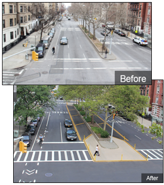
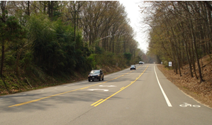
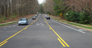
Speakers demonstrated how Road Diet projects have substantially evolved far beyond the original concept, which was simply the conversion of four-lane undivided roadways to three-lane roadways. For example, Road Diets have been successfully implemented in New York City on wide avenues that previously had five or more lanes, as shown in the before and after photos below.
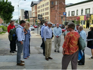
The peer exchange included a walking tour of a local corridor where a Road Diet is being considered for a stretch of Worcester's Main Street Central Business District. The existing cross section consists of four travel lanes (undivided) with sidewalks on both sides and on-street parking. The corridor includes 11 signalized intersections with average daily traffic of approximately 12,100 vehicles per day. Police reported a startling 297 crashes on the corridor over a 3-year study period. A recent road safety audit indicated concerns about intersection and corridor safety, deficient bicycle and pedestrian accom-modations, and assorted streetscape components.
The scope for MassDOT's Main Street Business District Streetscape Improvement project includes a Road Diet consisting of a revised cross section with three travel lanes, bicycle lanes for most of the project limits, and on-street parking lanes. The Peer Exchange participants split into two groups and walked along portions of the Main Street corridor to obtain a first-hand view of existing conditions and learn more about some of the issues and challenges associated with specific segments and intersection locations. This exercise provided a useful supplement to the technical information and Road Diet case studies presented at the Peer Exchange.
Throughout the exchange, participants discussed and shared a variety of Road Diet stories relating to items such as lane widths, traffic diversion, parking, access management, appropriate traffic volume thresholds, and funding. The Peer Exchange provided an opportunity for lively discussion between agencies regarding resources and efforts underway to promote Road Diets both internally (within DOTs, especially with executive leadership) and with the public. A Road Diet video produced by New Jersey DOT and a bicycle-oriented Road Diet brochure produced by Connecticut DOT were key takeaways for Peer Exchange participants seeking to improve the way they communicate about the purpose and benefits of Road Diets. Several agencies expressed interest in receiving FHWA's "Incorporating On-Road Bicycle Networks into Resurfacing Projects" (https://www.fhwa.dot.gov/environment/bicycle_pedestrian/publications/resurfacing/). Participants learned about the importance of developing a candidate list of potential projects so that, when opportunity presents itself through repaving programs, they can go back to the list and review and add appropriate locations.
As the meeting concluded, each participating State made a specific commitment to work towards further institutionalizing Road Diets and stated action items associated with furthering their commitment.
Planning for additional peer exchanges is underway for other States wishing to advance Road Diet implementation. If you're interested in receiving Road Diet technical assistance or scheduling a free Road Diet workshop, please contact Rebecca Crowe (rebecca.crowe@dot.gov) or Keith Harrison (keith.harrison@dot.gov). To learn more about the benefits of installing a Road Diet, visit: http://safety.fhwa.dot.gov/road_diets/.
By: John McFadden, FHWA Resource Center, and Betsey Tramonte, FHWA Louisiana Division
The Every Day Counts (EDC-3) Data-Driven Safety Analysis (DDSA) Initiative promotes making more informed decisions through the use of tools which allow users to explicitly quantify the safety implications of project investment decisions. The mission of the DDSA Initiative is to integrate safety performance into all highway investment decisions with the ultimate goal of reducing fatal and injury crashes.
The EDC-3 DDSA Initiative hosted three peer exchanges between May and July 2016 (in New Orleans, LA; Sterling, VA; and Kansas City, MO). These peer exchanges focused on how agencies successfully include safety analysis into the planning, environmental, design, and traffic operations disciplines. Exchange participants expressed specific interest in learning how data-driven safety analysis applications can be utilized in these different discipline areas.
Each event lasted 2 days and involved over 25 States nationwide. The exchanges revolved around technical presentations prepared by State representatives and national experts discussing the use of data-driven safety analysis tools and various project applications. Key elements included lessons learned and illustrations of how to use existing software and database tools on projects to lead practitioners to make more informed decisions by incorporating safety into the existing project development process.
Breakout sessions were used throughout the exchanges to allow participants to discuss their accomplishments and challenges associated with using DDSA tools. The end product of the breakout sessions were State-specific action plans to guide States' agencies in moving forward in applying DDSA solutions into existing business practices. One example of a specific State action item was to develop a DDSA training plan tailored to each business unit's needs within the State DOT. This plan would be developed based on a DDSA user needs document, which would include both the business units within the State DOT and external partners.
Based on feedback from peer exchange participants, the peer exchange format was beneficial for transferring information on the DDSA initiative and working through specific project-related issues regarding the application of safety analysis concepts and tools. Due to these efforts and successes, FHWA leadership has selected the Data-Driven Safety Analysis Initiative to continue into EDC-4, which is planned to begin in January 2017.
Your colleagues in the Office of Safety have been busy this year! Check out our newest products (released between March 1 and June 15)!
Reports/Guides:
Flyers/Info sheets:
Case Studies:
Newsletters:
Video:
Articles published in external publications:
By: Rebecca Crowe, FHWA Office of Safety
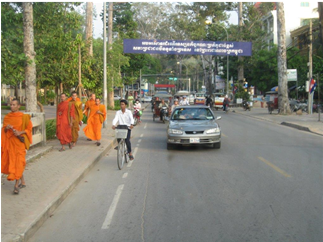
Across the Nation, travelers are continuously looking for ways to find safer and more efficient travel routes. Whether on their daily commute, walking to school, or just trying to get "from point A to point B," increasing safety for travelers is a win for everyone.
Installing a Road Diet is one way to achieve safer roads. A Road Diet is a roadway reconfiguration that improves safety, convenience, and quality of life for all road users, including pedestrians, cyclists, and public transportation passengers. A Road Diet can make it easier for pedestrians to cross the street and can also create room for bicyclists. In addition, this roadway safety solution can be a relatively low-cost option if planned in conjunction with reconstruction or simple overlay projects. Applying a Road Diet is a very inexpensive, simple process: it consists primarily of restriping roadways.
Two excellent examples of this type of Road Diet can be found in the city of Reston, Virginia, on Lawyers Road and Soapstone Drive. The two projects both took away one lane in each direction and added a center turn lane. These installations were so successful that in late 2015 they received a National Roadway Safety Award for Infrastructure and Operational Improvements (http://safety.fhwa.dot.gov/roadwaysafetyawards/).
Randy Dittberner, a Regional Traffic Engineer at the Virginia Department of Transportation (VDOT), led the effort in developing the two Road Diets. In a recent interview with the Office of Safety, Randy stated, "If you build a Road Diet with a paving project, it can be done at almost no cost. There are huge safety and livability benefits, as well as 'extras' like bike accommodations. Why wouldn't you want to apply a Road Diet when there are so many benefits?"
Public outreach was the greatest challenge and most critical element to this project. The VDOT team led efforts to clearly explain to the public how a Road Diet could improve the community. Travelers found comfort in knowing that this effort was not an attempt to impose travel restrictions but rather a roadway safety solution.
To find out if a Road Diet is right for your area, download our Road Diet Informational Guide today http://safety.fhwa.dot.gov/road_diets/info_guide/.
To learn more about Road Diets use cases and scenarios, download the Road Diet Case Studies Guide: http://safety.fhwa.dot.gov/road_diets/case_studies/roaddiet_cs.pdf.
The Federal Highway Administration's Office of Safety, in coordination with the Technical Services Team, is pleased to announce the FY 2016 ASAP awardees. Previous ASAP projects have provided training, workshops, and peer exchanges to the Focused Approach States for the past 10 years. The projects selected this year show a wide variety of opportunity for the awardees to improve safety in their States. The table below shows the States and the projects selected.
| State | Description | Amount Requested | Total Cost of Project |
|---|---|---|---|
| Kentucky 3 | Traffic and Safety Academy | $9,100.00 | $23,200.00 |
| New Jersey | New Jersey HFST Installation and Training for Safety Improvements | $9,450.00 | $14,385.00 |
| Alabama | Road Safety Workforce Capacity Building Peer Exchange | $14,468.00 | $32,000.00 |
| North Carolina | Pedestrian Crossing Assessment Training | $15,000.00 | $18,813.00 |
| Georgia | Best Practices NACTO Training | $9,900.00 | $13,900.00 |
| Florida 2 | Working Conference: Improving Florida's Intersection Safety and Decreasing Roadway Departures | $7,570.00 | $9,270.00 |
| Florida 1 | Bike Boxes: PSA and Outreach Campaign | $14,200.00 | $18,004.00 |
| Total | $79,688.00 | $129,572.00 | |
By: Yanira Rivera and Stuart Thompson, FHWA Office of Safety
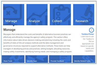
Whether you are a safety data guru, a junior analyst, or somewhere in between, the Roadway Safety Data Program (RSDP) Toolbox is for you! The Toolbox is a "one-stop shop" for your roadway safety data needs. The tools available come in the form of software, guides, or databases. The Toolbox, available at http://safety.fhwa.dot.gov/rsdp/toolbox-home.aspx, offers flexible features for transportation safety professionals with varying technical backgrounds. The easy-to-use search interface allows the user to apply the most effective method depending on their understanding of their role, responsibility, needs, and knowledge of related tools.
The first searching method involves the four primary topic area buttons: Manage, Analyze, Collect, or Research, where users can identify the appropriate task area either using the descriptions provided for each or use the list of roles and responsibilities that correspond to each task area.
Users can also search with the Advanced Search function. With this search technique, the user can enter the tool name or a key word to obtain a list of tools. Filters can then be applied to further refine the list of tools.
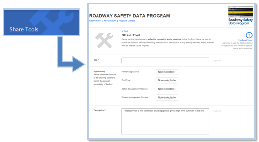
The tools are presented by title in alphabetical order along with the tool type and owner/sponsor. To learn more about a specific tool, users can simply click on the tool's name to access a detailed summary.
Since its inception in 2014, more than 140 tools have been added, and an additional 36 are scheduled to be added in the coming days. Here is a preview of two new tools in the Toolbox:
This information guide is designed to help users to:
This Excel-based software and associated application guide can help users to:
Both public and proprietary tools are welcome. To have your tool considered, click on the Share Tools link, fill out the short form with basic information about the tool, and click Submit Information. Once submitted, the RSDP Toolbox project team will receive an email and each tool will be reviewed for its inclusion. For additional information or questions about the tool, please contact Stuart Thompson at stuart.thompson@dot.gov.
By: Rebecca Crowe, FHWA Office of Safety
In a continued effort to address the safety of vulnerable users, many agencies are turning to Road Safety Audits (RSA). An RSA is a formal safety performance examination of an existing or future roadway or off-road facility and is conducted by an independent, experienced, multidisciplinary team. FHWA recently published a case study document that chronicles the efforts of several agencies to address motorcycle safety through RSAs.
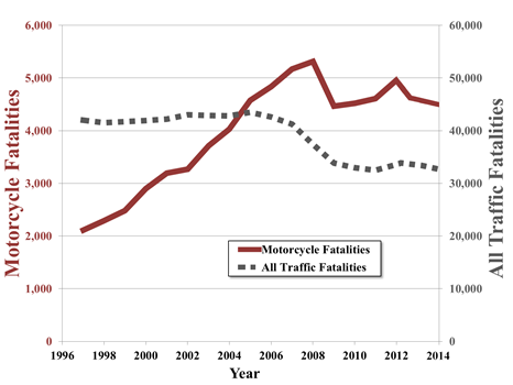
Motorcyclists are at a greater risk than many other roadway users. In 2012, motorcycles made up three percent of all registered vehicles in the United States, yet motorcycle fatalities accounted for 15 percent of total vehicle-related fatalities.

The Motorcycle Road Safety Audit Case Studies provides a review of the RSA process and three case study examples of RSAs at locations that had a demonstrated high frequency of crashes involving motorcyclists. The case studies include photographs, a project background, and key RSA findings and suggestions and will help Federal, State, tribal, and local agencies better understand conditions that affect motorcyclists and how to effectively address safety in the RSA process.
The case study report describes three RSAs conducted from 2012 to 2014 on facilities with documented motorcycle crashes. The RSA host agencies and locations included:
For these locations, motorcycles were incorporated into the RSA process by ensuring that some of the team members had expertise in motorcycle safety and had experience riding motorcycles. Some of the RSA teams included law enforcement officers who had riding experience or who were part of active motorcycle patrols, individuals at the Department of Licensing that provide motorcycle training, or members of motorcycle safety clubs. Additionally, during the kickoff meeting, RSA team members familiar with riding described and interpreted data to help determine contributing factors to crashes and their potential effect. They also provided details concerning critical conditions or locations.
During the audits, the RSA teams concluded that certain conditions appear to present challenges to motorcyclists. Some of these include:
RSA teams identified existing countermeasures, or those under review, to improve the safety of motorcyclists. These include the use of motorcycle-specific warning signage and the creation of pull-off areas that provide a respite and key safety and trip planning information for motorcyclists. However, a lack of detailed data is a key issue inhibiting a fuller understanding of the factors that affect the safety of motor-cyclists. This includes detailed crash data, but is particularly true with regard to motorcycle count data.
In each of the case study locations, the team applied the RSA process to understand the safety needs of motorcyclists. The RSAs helped bring attention to safety issues affecting motorcyclists by highlighting the effects of design and maintenance practices and by bringing together a multidisciplinary and multi-modal group of safety professionals that were able to clarify issues that may not have been adequately understood previously.
For a copy of the Motorcycle Road Safety Audit Case Studies, please visit http://safety.fhwa.dot.gov/rsa/resources/. For more information, please contact Rebecca Crowe at rebecca.crowe@dot.gov
By: Roya Amjadi, Office of Safety Research and Development
The "Evaluations of Low Cost Safety Improvements Pooled Fund Study" (ELCSI-PFS) (established 2005) includes 40 member States and is charged with conducting highway safety research under the DCMF program. The goal of this research is to develop reliable estimates of effectiveness for safety improvements. These estimates are determined by conducting statistical analyses using crash data for before-and-after periods on sites where safety improvements were implemented.
As a result of the limitations of current statistical methodologies, our ability to identify effective safety countermeasures for the most vulnerable users is also limited.
At this time, we only have a limited number of statistical methodologies (Empirical Bayes (EB), Cross-Sectional Studies, Case-Control Studies, and the recently added Propensity Scores Method) available to us for evaluating safety improvements. What's more, these methodologies are not applicable to broad areas of highway safety research and have limitations based on crash sample size. As a result of these limitations, our ability to perform data analysis and identify effective safety countermeasures for crash types with small sample sizes (e.g., pedestrian, bicycle, motorcycles, etc.) has suffered, and these road user groups may not fully benefit from timely highway safety improvements. Recent FARS statistics show pedestrian, bicycle, and motorcycle crashes are increasing, and crashes involving vulnerable road users are likely to be associated with more severe injuries compared to other types of crashes that do not involve this risk group.
The mission of the FHWA Development of Crash Modification Factors (DCMF) program, established in 2012, is to save lives by identifying new safety improvements that effectively reduce crashes and promote improvements for nationwide countermeasure installation by providing measures of safety effectiveness for each countermeasure. State departments of transportation (DOTs) and other transportation agencies need to have objective measures of safety effectiveness before investing in statewide safety improvements. Various statistical methodologies are heavily used for all studies performed under the DCMF program, but these methodologies have been borrowed from other statistical fields and have limitations in capability and applicability when used for highway safety research.
The FHWA and USDOT partners' comprehensive datasets with important real-world applications are waiting to be discovered–or rediscovered–by statisticians, economists, and other statistics-related fields.
Despite the limited statistical methodologies available, USDOT agencies such as the FHWA, NHTSA, and FMCSA have succeeded in developing and maintaining comprehensive and reliable data resources (i.e., Highway Safety Information System, Fatality Analysis Reporting System, and Motor Carriers Management Information System) that have historical crash and roadway data for multiple years. The Transportation Research Board's second Strategic Highway Research Program (SHRP 2) (2006-2015) has also collected an unprecedented amount of real-time data on driver behavior and the driving context. In addition, most State DOTs collect and manage significant amounts of crash data as well as data about roadway characteristics. Together, these comprehensive datasets with important real-world applications are waiting to be discovered–or rediscovered–by statisticians, economists, and other statistics-related fields. Using statistical science and developing new highway transportation-specific statistical methodologies will assist FHWA and its partners to predict and prevent highway fatalities and injuries.
For information on our efforts, visit https://www.fhwa.dot.gov/research/tfhrc/offices/safety/. For more information on the activities and publications of the Development of Crash Modification Factors (DCMF) program, see https://www.fhwa.dot.gov/research/tfhrc/projects/safety/comprehensive/dcmf/studies.cfm or contact Roya Amjadi at 202-493-3383 or roya.amjadi@fhwa.dot.gov.
By: Egan Smith and Michael Pina, FHWA ITS-JPO
Increasing numbers of Americans are walking and bicycling for their commutes, errands, recreation, and other travel. While this trend is great for reduced congestion and public health, it presents greater challenges when it comes to protecting the safety of our Nation's pedestrians–and the number of these travelers involved in accidents is on the rise. According to the National Highway Traffic Safety Administration, 2014 saw 4,884 pedestrians killed and an estimated 65,000 injured in traffic crashes in the United States. This crash-related death toll could continue to rise unless something is done.
The U.S. Department of Transportation (USDOT) understands that for our roads to be truly safe, we must address the special safety needs and challenges of pedestrians, bicyclists, and other nonmotorized users. The Department has spent more than a decade researching the integration of connectivity into our transportation system, and the results to date indicate that this technology has the potential to improve safety for all road users.
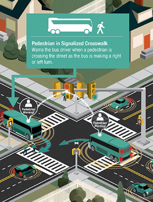
On average, a pedestrian is killed every 2 hours and injured every 8 minutes in traffic crashes. Pedestrians encompass a broad set of often vulnerable road users traveling outside of an automobile, including people walking, children being pushed in strollers, people using wheelchairs or other mobility devices, and passengers embarking onto and disembarking from buses and trains. The USDOT's research into vehicle-to-pedestrian (V2P) communication focuses on improving the safety and mobility of all of these transportation system users.
The technology being studied involves detecting the presence of pedestrians in or near the roads. Such detection systems can be implemented in vehicles, in the infrastructure, or with pedestrians themselves to provide warnings to drivers, pedestrians, or both. While in-vehicle warning systems are becoming more and more commonplace, perhaps the simplest and most apparent warning system for pedestrians is a handheld device, which would enable messages to be exchanged between pedestrians and road infrastructure such as traffic signals. The USDOT has several efforts underway to assess the benefits of pedestrian collision warning applications:
The USDOT believes that connected vehicles are the foundation for the next major innovation in transportation–self-driving or automated vehicles. Connectivity will help realize the full potential of automation. Cars that drive themselves will be able to communicate with other cars, traffic signals, and pedestrian cell phones to function safely.
Last year, Transportation Secretary Anthony Foxx declared pedestrian and bicyclist safety a top priority for the USDOT. The Department launched a pedestrian and bicyclist safety initiative that focuses many departmental resources on helping to improve the safety of the growing number of Americans traveling by bike or on foot to reach transit or other important destinations including work, job training, school, healthcare, and community services.
USDOT staff are closely coordinating the connected vehicles initative with related pedestrian and safety efforts to accelerate our progress toward improved safety for all transportation users.
By: Michael Griffith, FHWA Office of Safety
FHWA has a partnership with the World Road Association (WRA) in providing leadership and technical expertise in several areas including safety. The WRA's mission is to promote international cooperation on issues pertaining to roads and road transportation, and, with 122 government members worldwide, retains consultative status to the Economic and Social Council of the United Nations.
With FHWA's assistance, the WRA recently launched a comprehensive new Road Safety Manual (RSM). The focus of the three-part RSM is on guiding the management of the safe planning, design, operation, and use of road networks in low, middle and high-income countries. The RSM provides information on the effective management of road safety infrastructure. It includes new thinking on road safety and offers a clear argument on why adopting a Safe System approach is crucial for all countries. Elected officials, political appointees, road safety practitioners, health professionals, transportation engineers, and planners will all benefit from using the RSM.
Part one of the manual frames road safety as a global issue. Part two provides guidance on road safety management. Part three addresses the planning, design, operation, and use of a safe road network. Each chapter starts with a series of key messages summarizing the main points. The manual also offers advice for how newcomers to road safety can get started and continue to make progress. There are also activities that higher performing agencies should aim to accomplish.
The RSM is organized to allow users to start at any part in the manual. Readers may review the key messages at the beginning of each chapter to get an overall understanding of content. Further guidance is provided in the form of illustrative examples, case studies, and noteworthy practices. The case studies are from countries at all levels of development; however, there is a particular focus on lower- and middle-income countries.
Each chapter includes references to easily accessible documents or websites for further information. This Manual is a significant contribution to supporting the aims of the UN Decade for Action on road safety. For further information, please visit http://roadsafety.piarc.org/en or contact Michael Griffith at mike.griffith@dot.gov
The FHWA Office of Safety is pleased to announce the availability of several new resources to help States implement the Safety Performance Management Measures Final Rule under 23 CFR 490. These new resources are now available on the Safety PM webpage at http://safety.fhwa.dot.gov/hsip/spm/ and include the following:
Please share these new resources with your stakeholders and partners. FHWA is continuously working to develop additional resources and will post them to the Safety PM webpage as they become available.
For more information, please contact Dana Gigliotti at dana.gigliotti@dot.gov.
By: The Hon. Sallie Clark, Commissioner, El Paso County, Colo., and President, National Association of Counties
Every day, county officials like me are tasked with making important decisions to protect our residents' health and safety. County governments own and maintain 45 percent of the Nation's public local roads and approximately 4 out of every 10 bridges. We invest more than $122 billion annually in building infrastructure and maintaining and operating public works in order to ensure our communities are safe, affordable, attractive places to live and work. Local road safety is of utmost importance to county officials in all parts of the country. As president of the National Association of Counties (http://www.naco.org/), I have made the topic of transportation safety a central part of my presidential initiative, Safe and Secure Counties (http://www.naco.org/featured/safe-and-secure-counties).
Each year, a disproportionate number of the Nation's fatalities occur on local roads. In 2013, more than 12,000 people were killed on local roads across the United States; this is almost three times the fatality rate of the Interstate Highway System. Working together, county and other local elected officials, county and local engineers and planners, State agencies, and the FHWA can leverage our combined knowledge of safety and community issues to reduce roadway crashes, injuries, and fatalities. Effective collaboration and communication among local officials and community and safety stakeholders are necessary to achieve our ambitious yet achievable safety goals.
County officials across the country have led a wide range of partnerships to better promote local road safety. For instance:
On July 13, 2015, Secretary of Transportation Anthony Foxx signed a resolution reflecting the need to improve safety on county-owned roads and affirming that the U.S. Department of Transportation will work with NACo to improve road safety in America's communities. This resolution underscores the important role that local elected officials play in improving road safety in our communities. Building on the resolution, NACo has partnered with USDOT's Federal Highway Administration Office of Safety to discuss various aspects of and approaches to local road safety with county elected officials and professional staff. This partnership with USDOT is a key component of my presidential initiative at NACo, Safe and Secure Counties, to protect public safety, ensure public health, and promote local economies.
At NACo's Legislative Conference in February, we were fortunate to hear Michael Griffith, Director, FHWA Office of Safety Technologies, discuss the tools and resources available to county officials and safety practitioners, such as the new FHWA Office of Safety video and accompanying brochure, Local Elected Officials: Leading the Way in Local Road Safety (http://safety.fhwa.dot.gov/local_rural/training/fhwasa16018/). These resources give local elected officials a big-picture look at local road safety issues, and also to provide guidance on how to engage, collaborate, and coordinate actions with safety prac-titioners. Following this meeting, we have been pleased to host workshops in collaboration with the FHWA Office of Safety at NACo's Western Interstate Region conference in May, and NACo's Annual Conference in July, to ensure that county officials know what actions can keep our roads safe and secure.
Additionally, NACo has partnered with the FHWA Office of Safety to offer a series of articles in County News highlighting steps counties can take to promote transportation safety, including:
In addition, NACo and FHWA have hosted a webinar series to engage county leaders on this topic. View the webinar recording for "Enhancing Road Safety through the Improvement of Unsignalized Intersections" at http://www.naco.org/events/enhancing-road-safety-through-improvement-unsignalized-intersections. The recording for "Saving Lives through Local Road Safety Planning" is available at http://www.naco.org/events/saving-lives-through-local-road-safety-planning.
Finally, NACo is partnering with the National Center for Rural Road Safety to convene the National Working Summit on Transportation in Rural America in Denver, Colo., from September 7-9, to develop strategies to strengthen rural economies and reduce road fatalities. For more information and to register, visit: http://www.cvent.com/events/national-working-summit-on-transportation-in-rural-america/event-summary-c462978995ee4f9b9d9818cf010345e5.aspx.By: Kelly Jackson, Missouri Department of Transportation
This spring, the Missouri Coalition for Roadway Safety (MCRS) received a prestigious award from the American Public Works Association (APWA) for its extensive work on the State's strategic highway safety plans (SHSP) as part of a multi-year effort to improve roadway safety across Missouri.
Between 2005 and 2014, Missouri experienced a 39 percent fatality reduction, resulting in a total of 3,270 lives saved.
The MCRS comprises safety advocates from a broad spectrum of stakeholders, including law enforcement agencies; health care providers; courts; local, State and Federal government agencies; advocacy groups; planning organizations; and citizens. Since 2004, this group's focus has been to work with regional safety coalitions to identify safety concerns and develop targeted strategies for addressing them. These strategies are then incorporated into the Missouri SHSP, which in 2012 was entitled Blueprint to Save More Lives (Blueprint).
Each version of the Blueprint established a specific fatality reduction goal. The 2004 goal–to reduce fatalities to 1,000 or fewer by 2008–was met one year early. The second edition of the Blueprint called for 850 or fewer fatalities by 2012. That goal was met two years early in 2010, when Missouri's traffic fatalities stood at 821. The third edition of the Blueprint called for 700 or fewer fatalities by 2016. The third edition of the Blueprint established a goal of 700 or fewer by 2016. While this aggressive goal will be difficult to achieve, between 2005 and 2014 Missouri's annual traffic fatalities fell from 1257 to 766. In fact, in 2013 Missouri experienced the lowest number of traffic crash fatalities since 1945. This remarkable decrease is due in part to aggressive implementation of each of the State's strategic highway safety plans.
To date, the State's SHSPs have applied a number of successful strategies, including median guard cable, rumble strips, brighter stripes and bigger signs, more delineation, improved intersections, and key enforcement and education efforts. Implemented since 2005, these strategies have contributed to 6 consecutive annual decreases in traffic crash fatalities and 10 consecutive annual decreases in serious injuries. Between 2005 and 2014, Missouri experienced a 39 percent fatality reduction, resulting in a total of 3,270 lives saved. The fatality rate fell from 1.8 fatalities per 100 million vehicle miles of travel in 2005 to 1.08 in 2014.
Missouri's new 2020 fatality goal will be revealed at the Blueprint Conference held in St. Louis in October, 2016. Accomplishments and additional information from MCRS can be found at www.savemolives.com or on social media at Save Mo Lives.
By: Carrie Simpson, P.E., Traffic Safety Project Engineer, North Carolina Department of Transportation
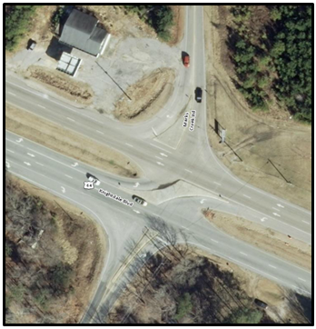
The North Carolina Department of Transportation (NCDOT) recently completed a study on the safety effectiveness of 93 unsignalized "synchronized street" intersections in the State. The study defines a synchronized street (also known as a superstreet, directional crossover, restricted crossing U-turn (RCUT), or J-turn) as an intersection where a direct left turn and through movement have been prohibited by concrete channelization on the minor leg(s) and/or the major leg(s). Where these movements are prohibited, travelers who want to cross or turn left at the intersection must first turn right and then make a U-turn to return to their desired route.
The unsignalized synchronized streets included in the analysis were installed between 1997 and 2012. Most of the sites are four-lane divided roadways crossing two-lane roadways, although a handful of sites have major road cross-sections of two-lanes or five or more lanes. In the post-installation period, the average AADT for the treated intersections is about 26,000 vehicles per day, with a minimum of about 8,000 vehicles per day and a maximum of about 53,000 vehicles per day. More than 80 percent of the study sites eliminate through and left movements on the minor road alone. The remaining sites eliminate through and left movements on a combination of the main road and minor road, or on the major road alone. Some of the synchronized street installations build in a downstream U-turn location as part of the project, but others use existing downstream median openings or existing intersections for the U-turn maneuver.
A before-and-after crash analysis with consideration for traffic increase was used to calculate Crash Modification Factors (CMFs) and the associated Crash Reduction Factors (CRFs). The study included an average of 4.2 years of crash data per site in both the before and the after period. Highway Safety Manual safety performance functions (SPFs) were used to determine the effect of traffic volume trends on predicted crash frequency. There were more than 1,000 total crashes included in the post-installation sample.
The study results demonstrate a 59 percent reduction in total crashes, a 71 percent reduction in fatal and injury crashes, an 88 percent reduction in fatal and severe (Class-A) injury crashes, and an 80 percent reduction in frontal impact crashes at the 93 sites selected. All results are statistically significant at the 95 percent confidence interval.
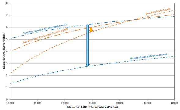 Unlike the standard traffic signals included in the study, sites converted from two-way stop control to unsignalized synchronized streets generally demonstrate large total crash reductions across intersection AADT ranges.
Unsignalized synchronized streets are an effective safety countermeasure, especially when compared to traditional full-movement traffic signals. Total crashes per year per intersection are plotted as a function of the intersection AADT for a group of 76 synchronized streets pre- and post-installation and a group of 28 standard traffic signals pre- and post-installation. The pre-installation condition for all sites is a two-way stop. The NCDOT plotted trend lines for each category of sites: Two-Way Stop (Pre-Synchronized Street), Two-Way Stop (Pre-Standard Traffic Signal), Unsignalized Synchronized Street, and Standard Traffic Signal. The general trends show a large reduction in total crashes at sites converted from two-way stops to unsignalized synchronized streets across the span of intersection AADT ranges, and more modest reductions to an increase in crashes at sites converted from two-way stops to standard traffic signals.
By: Esther Strawder, FHWA Office of Safety, and Elissa Goughnour, VHB
Highway traffic safety analysis is a multi-dimensional process involving roadway characteristics, volumes, and crash data. State agencies may encounter difficulties sharing data among agencies and integrating the multiple data sources into a single safety analysis. The University of Maryland's National Study Center for Trauma and Emergency Medical Services (NSC) receives data from several State agencies and provides integrated data analysis using the Crash Outcome Data Evaluation System (CODES) methodology.
CODES is a State-based program created in 1992 by the National Highway Traffic Safety Administration (NHTSA), and the National Center for Statistics and Analysis (NCSA). NHTSA implemented the program to help States develop data linkage programs, as crash data alone do not capture the full consequences of motor vehicle crashes. The intent of the CODES program was to provide a more comprehensive understanding of motor vehicle crashes by linking crash, vehicle, and behavior characteristics to their specific medical and financial outcomes. NHTSA supported the program until 2013, anticipating that States would continue the effort using their own funding sources. In Maryland, the NSC has continued to use CODES to inform State legislation, agency policy, and behavioral countermeasure programs.
The NSC's mission is to prevent death and disability caused by injury and sudden illness. Established by Congress in 1986, it is part of the Shock, Trauma, and Anesthesiology Research Center (STAR) in the University of Maryland School of Medicine.
The NSC staff, including epidemiologists, physicians, statisticians, and database coordinators, conducts research related to the causes, treatment, and outcomes of traumatic injury and sudden illness. NSC studies have been used to improve vehicular safety, to refine patient care, and to develop public education programs for the prevention of trauma. The NSC staff also collaborates with government agencies, professional associations, universities, and private enterprises to increase understanding of trauma epidemiology and emergency medical system response.
NSC uses data from a variety of sources, including three core data sets (crash, emergency medical services (EMS), and hospital) along with ancillary data sets such as driver licensing, vehicle registration, citation, motorcycle training, trauma registry, and others. The NSC also uses a General Use Model (GUM) of regularly collected data. The GUM data elements:
While NSC staff have been able to draw on established relationships, the University has formalized those relationships with data use agreements and the creation of an oversight board, the CODES Board of Directors, which is composed of data-owners. The establishment of these agreements and creation of the oversight board facilitated access to and analysis of data throughout the State.
The Maryland CODES Board of Directors meets once a year. Due to the positive relationships that have been strengthened by the CODES Board of Directors and the establishment of data use agreements, the University has been able to successfully continue its work with these various agencies, despite the sunsetting of support from NHTSA for the CODES program.
American Society of Civil Engineers Convention, September 28 - October 1, 2016, Portland, OR. This annual convention is designed to offer integrated, multicultural, technical, and educational components to meet the needs of the profession. The convention will address the state of the industry and profession, professional development, multi-disciplinary technical topics, natural and man-made disasters, strategic issues, public policy, significant projects, among others. For more information, visit: http://2016.asceconvention.org/
19th Annual National Tribal Transportation Conference, October 3 – October 7, 2016, Anaheim, CA. The NTTC 2016 will bring together tribal, Federal, State, and private interests that work in the field of tribal transportation. The conference will provide information and resources for all who are committed to improving the transportation infrastructure of Indian country and the safety of those who live, work and travel the roadways of Indian lands. A wide variety of attendees are anticipated to attend, including tribal leaders; tribal transportation program personnel, tribal government leaders, Federal and State transportation personnel, and private transportation professionals. For more information, visit http://nttc.nijc.org/registration-3/
2017 Transportation Research Board Annual Meeting, January 8 – 12, 2017, Washington, DC. The 96th Annual Meeting will include an information-packed program that is expected to attract more than 12,000 transportation professionals from around the world. The meeting program will cover all transportation modes, with more than 5,000 presentations in nearly 750 sessions and workshops, addressing topics of interest to policy makers, administrators, practitioners, researchers, and representatives of government, industry, and academic institutions. The spotlight theme for the 2017 meeting is "Transportation Innovation: Leading the Way in an Era of Rapid Change." For more information, visit http://www.trb.org/AnnualMeeting/AnnualMeeting.aspx
is a publication of the U.S. Department of Transportation, Federal Highway Administration.
The Federal Highway Administration publishes the Safety Compass newsletter three times a year. We can be reached at:
FHWA Office of Safety
1200 New Jersey Ave. SE
Room E71-320
Washington, DC 20590
The Safety Compass is available online at the FHWA Office of Safety web site at: http://safety.fhwa.dot.gov/newsletter/safetycompass/.
We welcome your comments and highway safety-related articles. The purpose of this newsletter is to increase highway safety awareness and information and to provide resources to help save lives.
We encourage readers to submit highway safety articles that might be of value to the highway safety community. Send your comments, questions and articles for review electronically to Tara McLoughlin at: tara.mcloughlin@dot.gov