U.S. Department of Transportation
Federal Highway Administration
1200 New Jersey Avenue, SE
Washington, DC 20590
202-366-4000
View the PDF Version [836 KB]
![]()
U.S. Department of Transportation
Federal Highway Administration
In this issue:
Separated Bike Lane Planning and Design Guide
Road Diet Case Studies Available
Ped/Bike Counting Program Kick-Off
Hard Copies of Resident's Guide Avail.
NHTSA Bike Fact Sheet Available
Design Resource Index Available
New Resourses From Other Organizations
"(The summit) is open to all mayors. If we can get a critical mass for mayors involved in this ... it will create groundswell across the country." —Secretary of Transportation |
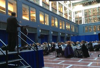
As mentioned in the Winter 2015 edition of this newsletter, U.S. Secretary of Transportation Anthony Foxx last Fall announced a new initiative to reduce the growing number of pedestrian and bicyclist injuries and fatalities through a comprehensive approach that addresses infrastructure safety, education, vehicle safety and data collection. As part of that initiative, the Secretary also urged participants at a U.S. Conference of Mayors meeting in January to spend a year working to make their cities safer for bikers and walkers.
In March, the USDOT and cities from across the nation launched the Challenge during the Mayors' Summit for Safer People, Safer Streets at USDOT headquarters in Washington, DC. Mayors and other elected city officials participate by leading a call to action and forming a local action team to advance safety and accessibility goals by taking on one or more Challenge activities outlined below.
Over the course of the year, USDOT will invite Challenge Cities to participate in forums and webinars and learn about available resources to help them accomplish their Challenge activity goals. Well over 200 cities have signed up. The Challenge is based on the 2010 USDOT Policy Statement on Bicycle and Pedestrian Accommodation. You can download an executive summary of the Mayors' Challenge here.
"Connected and comfortable infrastructure that makes bicycling a viable transportation choice for more people is one strategy to meet the challenges outlined in the U.S DOT's Beyond Traffic report." –Acting Federal Highway Administrator Gregory G. Nadeau. |
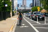
During National Bike Month, the Federal Highway Administration's (FHWA) announced availability of the new Separated Bike Lane Planning and Design Guide.
A separated bike lane(sometimes referred to as a "cycle track" or "protected bike lane") is a portion of a roadway for bicyclists that is physically separated from motor vehicle traffic.
These lanes are an important tool communities can use to build safe, comfortable, and connected networks of bicycle infrastructure that meet the needs of people of all ages and abilities. They have the potential to improve traffic safety for all street users, especially when implemented as part of a "road diet" or other traffic calming project and can help to organize all traffic modes, while reducing pedestrian crossing distances and decreasing "leapfrogging" between buses and bicyclists.
FHWA's guide outlines planning considerations and design options for this innovative bicycle facility. It provides information on one and two-way facilities, outlines different options for providing separation, and highlights midblock design considerations including driveways, transit stops, accessibility, and loading zones.
Intersection design is also taken into consideration, including the related operations, signalization, signage, and on-road marking concerns. In addition, it provides communities with case studies highlighting notable practices and lessons learned across the country.
The Guide builds on current policy to provide pedestrian and bicycle accommodations and on support for design flexibility. It will inform U.S. DOT's ongoing Safer People, Safer Streets initiative as well as efforts to improve access to opportunity for everyone.
Connected and comfortable infrastructure that makes bicycling a viable transportation choice for more people is one strategy to meet the challenges outlined in the U.S DOT's Beyond Traffic report.
A webinar introducing the guide took place June 2 and the recording can be viewed here.
A new FHWA report, Road Diet Case Studies, features 24 examples of how Road Diets are being used throughout the United States. Road Diets are a low-cost strategy that reallocates a road's cross section to safely accommodate all users and provide operational benefits.
The report provides state and local agencies and tribal governments with examples and advice on planning and implementing Road Diets in their own jurisdictions.
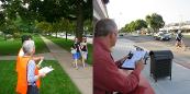
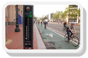
The FHWA launched a new pilot project to help metropolitan planning organizations (MPOs) to use portable automatic counters for tallying pedestrians and bicyclists.
The one-year project, Bicycle-Pedestrian Count Technology Pilot Program, is providing funds to 10 MPOs to purchase equipment that they will use to collect counts at various locations within their MPO planning areas. In return, the MPOs will share their data and experiences with FHWA and other organizations. FHWA will use that information to inform new guidance on automated counting technology.
Throughout the project, the Pedestrian and Bicycle Information Center (PBIC) and FHWA will provide technical assistance on how to develop a count program and how to collect and analyze the data.
The MPOs participating in this project are:
As mentioned in the Winter 2015 edition of this newsletter, the FHWA Office of Safety released a new guide, A Resident's Guide for Creating Safer Communities for Walking and Biking. Hard copies of the guide are now available to order in limited quantities from the FHWA Safety website.

The National Highway Traffic Safety Administration posted the Bicycle Traffic Safety Fact Sheet recently.
In 2013 (the most recent year that complete data is available) there were 743 cyclists killed and an estimated 48,000 injured in motor vehicle traffic crashes. cyclist deaths accounted for 2 percent of all motor vehicle traffic fatalities and injured cyclists made up 2 percent of the people injured in traffic crashes during the year.
The number of cyclists killed in 2013 is 1 percent higher than the 734 killed in 2012. This is the third year straight of increases.
The FHWA and the Pedestrian and Bicycle Information Center recently announced the availability of the Design Resource Index to help planners and engineers determine which design guide to use for various facilities.
The Design Resource Index lists types of facilities across three areas: on-street bicycle facilities, shared use paths, and pedestrian facilities, and indicates which national resource manuals or guides cover them. The matrices include design guidance from FHWA, the Institute of Transportation Engineers (ITE), American Association of State Highway and Transportation Officials (AASHTO), National Association of City Transportation Officials (NACTO), and the U.S. Access Board.
FHWA developed this resource to support efforts to document and promote connected pedestrian and bicycle networks. It will also inform several Challenge Activities as part of USDOT's Mayors' Challenge for Safer People, Safer Streets.
FHWA is asking users to provide observations and feedback as they use the index, including input on existing gaps in design guidance, research needs, and additional tools and resources that would help practitioners navigate between various design resources. Please email feedback to Dan Goodman.

Tamara Redmon, Pedestrian Safety Program
Manager
Federal Highway Administration
1200 New Jersey Avenue SE
Room E71-303
Washington, DC 20590
Phone: 202-366-4077
Fax: 202-366-3222
E-mail: tamara.redmon@dot.gov
This Pedestrian Forum is available on the Web at http://safety.fhwa.dot.gov/ped_bike/pedforum/
To receive information on future newsletters, please use the e-subscription service provided on this site: http://safety.fhwa.dot.gov/esubscribe.cfm#ped. Scroll down to "Pedestrian and Bicycle Safety" and select "subscribe" next to "Pedestrian Forum."
Helping Communities to provide safe and convenient transportation choices to all citizens, whether it's by walking, bicycling, transit, or driving is a high priority of the U.S. Department of Transportation and the Obama Administration. Each year, unfortunately, pedestrian fatalities comprise about 13 percent of all traffic fatalities and there are approximately 5,000 pedestrian deaths. Another 70,000 pedestrians are injured in roadway crashes annually. Pedestrian safety improvements depend on an integrated approach that involves the four E's: Engineering, Enforcement, Education, and Emergency Services. The Pedestrian Forum highlights recent pedestrian safety activities related to the four E's that will help save lives.
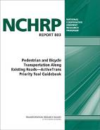
This guidebook presents the ActiveTrans Priority Tool (APT)," a step-by-step methodology for prioritizing improvements to pedestrian and bicycle facilities, either separately or together as part of a "complete streets" evaluation approach. The methodology is flexible, allowing the user to assign goals and values that reflect those of the agency and the community.
It is also transparent, breaking down the process into a series of discrete steps that can be easily documented and communicated to the public. The guidebook is supplemented by a CD that contains a programmed spreadsheet to facilitate implementation of the ActiveTrans methodology, as well as a final report that documents the research approach, findings, and conclusions.* The guidebook will be very useful to planners and other staff responsible for the most effective allocation of scarce resources to where they will provide the most benefit.
The Transit Cooperative Research Program just released Report 175 Guidebook on Pedestrian Crossings of Public Transit Rail Services. Rail transit services provide a high-capacity travel option for trips between major origin-destination pairs in an urban area, allowing pedestrians to travel to many more places than otherwise feasible on foot.
Improving pedestrian access to rail transit stations benefits the pedestrian by providing a safer and more usable route. Improving pedestrian access also benefits rail transit by resulting in a more attractive service and improved consistency at crossings.
The Guidebook discusses issues associated with pedestrian crossing of public transit rail services and provides examples of treatments in use. Included within the Guidebook are summaries of rail transit service options, safety and accessibility issues related to pedestrians and rail crossings, and methods of selecting appropriate treatments for a given crossing. A collection of existing treatments is described, and case studies provide additional insight on the process for identifying and implementing pedestrian crossings.

