U.S. Department of Transportation
Federal Highway Administration
1200 New Jersey Avenue, SE
Washington, DC 20590
202-366-4000
| < Previous | Table of Content | Next > |
Off-road facilities can provide low-stress environments for bicycling and walking that are separate from motor vehicle traffic. They can be great places for novice and child bicyclists to try out their riding skills prior to taking trips on urban streets. While they have many positive features, design of off-road trails must be done with the same care and attention to recognized guidelines as design of bike lanes on roadways. In addition, trails are often extremely popular facilities that are in high demand among rollerbladers, bicyclists, joggers, people walking dogs, and a variety of other users. The resulting mix and volume of non-motorized traffic can create dangerous conditions that should be anticipated during the design phase.
The discussion that follows addresses the types and design requirements of different trail users, and provides a brief overview of design issues and guidelines. More detail on multi-use trail design and engineering is provided in national guidelines set by AASHTO and the MUTCD.
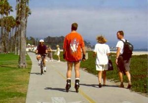
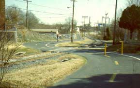
Trail user conflicts are an issue when on wide trails like this coastal trail in Santa Barbara, CA.
Only in very few instances is a trail used exclusively by one type of user. People routinely walk on "bicycle paths" and mountain bicyclists have been known to use "equestrian trails." In most cases, it must be assumed that trails will be shared by all types of users of all ages and abilities. These different trail users have different objectives, which can result in conflict. Some use the trail to get to work. Others use it to walk the dog, jog, or stroll with their children. By understanding the needs of these users and designing trails to accommodate expected levels and types of use, you can build a trail system that plays an important role in the community or region's transportation and recreation network for years to come.
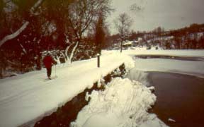
Trails can be designed to include year-round activities such as cross-country
skiing, sledding, and snowmobiling where appropriate. (Erie
Canal Trail, Syracuse, NY)
The following resources are recommended as sources of specific information on trail design and construction:
Conflicts on Multiple-Use Trails, Roger Moore, Federal Highway Administration, FHWA-PD-94-031, 1994.
Greenways - A Guide to Planning, Design and Development, The Conservation Fund, Charles Flink and Robert Searns, 1993.
Guide for the Development of Bicycle Facilities, American Association of State Highway and Transportation Officials, 1999.
Manual on Uniform Traffic Control Devices (MUTCD), USDOT, latest edition (for signing and pavement marking on trails).
Public Trail Access: A Guide to the Protection of Arizona's Trails, Arizona State Parks, Arizona State Committee on Trails, 1995.
Rails-With-Trails: Sharing Corridors for Recreation and Transportation, Brillot and Winerich, Rails-to-Trails Conservancy, 1993.
Signs, Trails and Wayside Exhibits - Connecting People and Places, Suzanne Trapp, Michael Gross, and Ron Zimmerman, UWSP Foundation Press, University of Wisconsin - Stevens Point, Wisconsin 54481, 1994.
Trail Design, Construction and Maintenance Guidelines, Arizona State Parks, Arizona State Committee on Trails, 1995.
Trails for the Twenty-First Century - Planning, Design and Management Manual for Multi-Use Trails, Edited by Karen-Lee Ryan, published by the Rails-to-Trails Conservancy, 1400 Sixteenth Street, N.W., Suite 300, Washington, D.C. 20036, (202) 331-9696.
Among the many types of trails are the following:
All of these can be designed for use by pedestrians (including joggers, casual strollers, hikers, in-line skaters, and others), people with disabilities, bicyclists, and equestrians. What distinguishes one type of trail from another is, primarily, its context.
Consideration of trails in this course lesson will focus primarily on urban trails and pathways, including rail-trails and trails in greenways.
More than 10,000 miles and 1,000 trails are now in place nationwide, and well over 100,000 miles of future rail abandonments make this one of the most important programs. Abandoned rails provide:
Today, there are many active rail, utility, and other corridors where a bit of imagination and lots of negotiation can lead to successful shared corridors. Building partnerships has led to excellent trail links and full-length trails.
Issues in building partnerships include:
The Rails-to-Trails Conservancy (Tel: (202) 331- 9696, Fax: (202) 331-9680) offers a wide variety of training and information resources related to trails within rail rights-of-way. Especially recommended is Rails-With-Trails: Sharing Corridors for Recreation and Transportation , by Michael Brillion and Julie A. Winterich, available through the Rails-to-Trails Conservancy.
Trails are rarely successful without the support and approval of adjacent
property owners and the community.
National guidelines for the design of multi-use trails are provided by AASHTO's Guide for the Development of Bicycle Facilities (1991). Nearly one-third of the guide is devoted to trail design, and the requirements are quite detailed. The reader is cautioned that the following section of this manual is intended to provide further depth only on design issues that the AASHTO Guide does not fully cover. The AASHTO Guide should be used as a companion text to this chapter.
Multi-use trails are physically separated from motor vehicle traffic (except at crossings with streets) and are built either within an independent right-of-way (such as a utility or railroad right-of-way), or along specially acquired easements across private lands. Trails cater to a variety of users, including bicyclists, pedestrians, joggers, rollerbladers, and horseback riders. Possible conflicts between these user groups must be considered during the design phase, since bicyclists often travel at a faster speed than other users.
Multi-use trails can help bicyclists and walkers avoid congested urban areas, although they sometimes do not provide access to important destinations in congested areas. Off-road trails offer a convenient and pleasant alternative, as well as an opportunity for a novice bicyclist to get some riding experience in a less threatening environment. Although multiuse trails usually attract a higher percentage of Group B (basic) and Group C (child) bicyclists, Group A (advanced) bicyclists can also benefit from their use.
Trail Width and Traffic Control The minimum width for two-directional trails is 3 meters (10 feet); however 3.7-meter to 4.3-meter (12 to 14 feet) widths are preferred where heavy traffic is expected. Due to the popularity of offroad trails, centerline stripes should be considered for paths that generate substantial amounts of pedestrian traffic, and speed limits or cautionary signs should be posted. Trail etiquette signing should clearly state that bicycles should give an audible warning before passing other trail users.
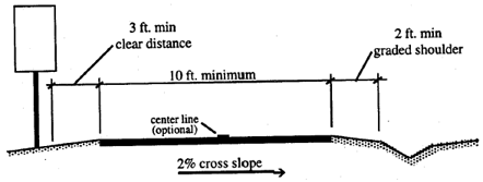
Typical cross-section for multi-use trails. Source: NCDOT
In the past, "bicycle sidepaths" (bikeways immediately adjacent to roadways) were developed with the concept of separating bicyclists from roadways in order to reduce opportunities for conflict. It is now widely accepted that bicycle paths immediately adjacent to roads actually cause greater conflicts. These sidepaths create the following problems (excerpt from AASHTO's Guide for the Development of Bicycle Facilities, 1991):
For these reasons, the AASHTO Guide further states that there should always be a minimum of 1.5 meters (5 feet) between the trail and the roadway.
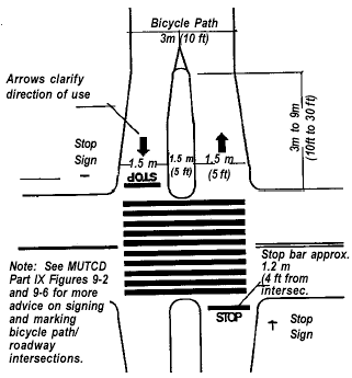
Alternative approach to trail/roadway intersections. Source: NCDOT
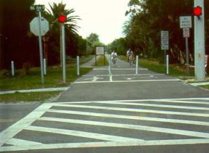
Trail/roadway intersections can become areas of conflict if not carefully designed. For at-grade intersections, there are usually several objectives:
|
Intersections and approaches should be on relatively flat grades. In particular, the bicyclist should not be required to stop at the bottom of a hill. Additional guidance on trail/roadway intersections is provided by AASHTO's Guide for the Development of Bicycle Facilities.
The need for parking should be anticipated during the master planning process for the trail system. Adequate parking at trailheads is necessary so that trail users do not park on the shoulder of the road near intersections, blocking the sightlines of both motorists and trail users.
For high-speed multi-lane arterials and freeways, the only viable solution may be a grade-separated crossing. Overpasses can be extremely expensive and marginally successful if users are expected to climb long entrance ramps. Underpasses should be of adequate width and should be well lit with vandalism-resistant fixtures. Approach ramps for grade-separated crossings must meet ADA or ANSI standards.
CROSS SECTION
PLAN VIEW - MARKING PLAN
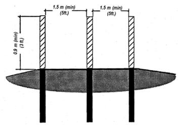
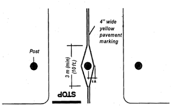
Reflectorized post barrier used to keep motor vehicles off bicycle
paths and marking plan. Source: California Highway Design
Manual , Caltrans, 1987.
Unauthorized motor vehicle access is an issue at some trail/roadway intersections. Trail bollards are the most effective method of limiting unwanted motor vehicles. However, much care should be taken in their use because they present an obstacle when located in the travel path of bicycles and pedestrians. Centerline pavement striping should be used to increase the visibility of bollards located in the center of the trail, as shown in the detail on this page.
Bollards should be painted a bright color and permanently reflectorized to maintain their visibility. Bollards should be sited 9 meters (30 feet) in advance of the intersection, so that cyclists can fully concentrate on maneuvering through the bollards and still have time to prepare for the upcoming intersection.
Bollards should be 0.9 meter (3 feet) tall, and can be constructed of a variety of materials. Several commercial manufacturers offer bollards that can be unlocked and removed to allow emergency vehicle or maintenance access.
Typical pavement design for off-road multi-use trails should be based on the specific loading and soil conditions for each project. Trails designed to serve bicycle transportation purposes should be composed of a hard surface, such as asphalt or concrete, and should be designed to withstand the loading requirements of occasional maintenance and emergency vehicles.
In some circumstances, given an extremely stable trail bed (such as a rail-trail) and excellent drainage conditions, a soft-surface trail may be acceptable. Careful consideration should be given to the amount of traffic the specific trail will generate, as these surfaces tend to deteriorate with heavy use. These trails must also meet the standards set by AASHTO's Guide for the Development of Bicycle Facilities (1999).
One important concern for asphalt multi-use trails is the deterioration of trail edges. Installation of a geotextile fabric beneath a layer of aggregate base course can help to maintain the edge of the trail. It is also important to provide a 0.6 meters (2 feet) wide graded shoulder to prevent trail edges from crumbling.
Text and graphics for this lesson were derived from the following sources: AASHTO, Guide for the Development of Bicycle Facilities, 1999.
City of Philadelphia, Bicycle Facility Design Standards, 1998.
Drake and Burden, Pedestrian and Bicyclist Safety and Accommodation Participant Workbook , NHI Course #38061, FHWA-HI-96-028, 1996.
Also see Section 10.3 of this lesson for a listing of trail design publications.
| < Previous | Table of Content | Next > |