U.S. Department of Transportation
Federal Highway Administration
1200 New Jersey Avenue, SE
Washington, DC 20590
202-366-4000
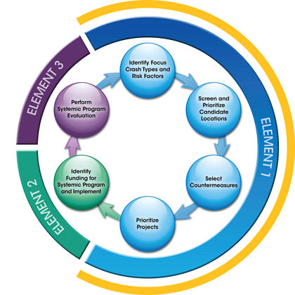
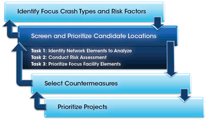
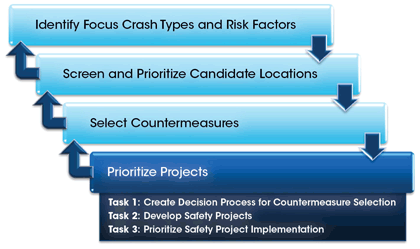
The systemic safety planning process (Element 1 of the Systemic Safety Project Selection Tool) consists of the four steps shown in Figure 3. Each step can be scaled based on the availability of technical resources and the quality or quantity of data available to support different analytical approaches. The systemic safety planning process is similar to most common safety management processes. The systemic safety planning process involves identifying the problem, screening and prioritizing candidate locations, selecting countermeasures, and prioritizing projects.
The premise that makes systemic safety planning different from traditional network screening techniques is that it looks for similar issues across the roadway system rather than focusing on select locations with high crash histories or densities. The systemic safety planning process begins by looking at systemwide data to analyze and identify focus crash types (those representing the greatest number of severe crashes) and potential risk factors. As the downward arrows indicate, the approach then moves to a micro-level risk assessment of locations across the network, which then leads to selecting relevant mitigating countermeasures most appropriate for broad implementation across those locations, and prioritizing projects for implementation. The upward arrows indicate that the results of one step might suggest the need to return to a previous step and make adjustments before continuing the process.
FIGURE 3. Systemic Safety Planning Process
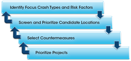
The following chapters (Identify Focus Crash Types and Risk Factors, Screen and Prioritize Candidate Locations, Select Countermeasures, and Prioritize Projects) further describe the four steps of the systemic safety planning process. Each chapter includes a discussion of the objective, data needs, tasks, and outcomes, along with examples illustrating the fundamental process for each step.
The systemic safety planning process builds on the Federal Highway Administration (FHWA) guidance to develop SHSPs and structure an HSIP using data-driven processes. The four-step process uses basic types of crash, roadway, and traffic volume data that are recommended by the FHWA for use in safety analysis efforts. Several agencies actively applying the systemic approach to safety and conducting research relative to systemic safety improvement also use these types of data. The following chapters describe in detail the specific types of data associated with each step in the systemic safety planning process. These data are recommended for each step because they represent elements that can impact safety performance of a facility. Although agencies might not currently maintain all these data elements, more detailed data provide the opportunity to more specifically identify facility types and risk factors.
The basic objective of the systemic safety planning process is to identify candidates for safety investment. Candidate identification results from comparing the actual conditions of segments, curves, and intersections with a set of observed characteristics associated with the locations where the focus crash types actually occurred. The data-driven process identifies the observed characteristics (risk factors) associated with the focus crash type. The systemic safety planning process uses selected risk factors to differentiate one segment from another, one curve from another, and one intersection from another in order to prioritize these facilities and give higher priority to locations where there is greater potential for future severe focus crashes. The data suggested to support the systemic approach are not intended to be prescriptive; some agencies currently use these types of data to successfully advance a systemic approach to safety. The systemic safety planning process can be adapted to meet agency-specific needs or crash reduction goals, consistent with the data available. The systemic planning process produces results with minimal levels of data; greater levels of data, however, support a more refined prioritization.
The objective of the first step in the systemic safety planning process is to identify risk factors commonly associated with each focus crash type experienced across a system. This step involves reviewing systemwide (i.e., macro-level) crash data and identifying potential risk factors for further analysis. Identification of potential risk factors does not necessarily imply the observed characteristics "caused" the crashes; rather, the characteristics are useful to identify the situations in which the crashes occurred, so that similar "looking" locations can be identified and prioritized.
The identification of focus crash types and risk factors results from using a range of data elements. Following are the minimum recommended crash data elements:
The FHWA's Model Inventory of Roadway Elements Fundamental Data Elements (MIRE FDE) identified for the HSIP is a good starting point for determining which roadway data to collect for a systemic analysis because it includes many of the roadway and traffic volume data elements recommended for use in this first step (FHWA, 2012). However, other road characteristics, such as shoulder width and type or roadway curvature, should be investigated when possible. The road and intersection data inventory is typically available in a geographic information system (GIS) or database, which should be linked with the crash records system. Ideally, the various data sets would incorporate the same time period. When volume data are from an earlier time period than crash data, first consider if changes have occurred that make the volumes no longer relevant (i.e., economic growth). If little change has occurred, agencies can consider using older traffic volumes. To compensate for greater change, agencies can estimate current traffic volumes by applying a growth factor appropriate for the region or jurisdiction.
The systemic safety planning process focuses on severe crashes (defined as fatal plus serious injury crashes) to be consistent with national safety programs. Furthermore, focusing on severe crashes reduces the scale of the effort and resources required to gather supplemental data if needed.
The data-gathering effort is an iterative process; as such, all data do not need to be collected at the beginning of the process. For example, the focus facility types selected will determine the necessary roadway and volume data to be collected to identify potential risk factors.
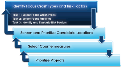
The first step of the systemic safety planning process—identifying and understanding the risk factors commonly associated with the focus crash types—includes a series of analyses involving three tasks (Figure 4). The first task refines the problem identification from all crashes to a few focus crash types for an entire system or subregion. Further investigation through additional analyses attains a more comprehensive understanding of the facility type and risk factors (i.e., roadway characteristics) commonly linked with the severe focus crash types.
FIGURE 4. Systemic Safety Planning Process: Tasks to Identify Focus Crash Types and Risk Factors
Task 1 in the step to identify focus crash types and risk factors involves conducting a systemwide analysis of crash types to select those representing the greatest potential to reduce fatalities and severe injuries. This effort typically results in identifying the crash types that represent the greatest number of severe crashes across the system being analyzed.
A good starting point for identifying focus crash types is a state or regional SHSP, which documents emphasis areas (i.e., focus crash types) for the state or region's safety program. These emphasis areas were likely identified through a data-driven process, which is a primary principle of the systemic safety planning process. State agencies with completed Roadway Departure and Intersection Safety Implementation Plans can identify these as focus crash types for their systemic safety programs. As such, the analysis summaries contained in the plans are useful for the subsequent tasks that identify focus facilities and risk factors. Agencies can also refer to safety plans in which emphasis areas specific to their jurisdiction have been identified through a similar data-driven approach.
If the state or regional SHSP does not cover the roadway type or region of interest, then referencing the emphasis areas identified in the American Association of State Highway and Transportation Officials (AASHTO) SHSP is useful to determine what types of crashes require further investigation. Depending upon their needs, an agency can add additional emphasis areas to the list of 22 emphasis areas in the AASHTO SHSP (AASHTO, 2005). Some common additions include winter weather crashes, animal crashes, and driveway/access crashes. If a state SHSP added emphasis areas to AASHTO's list, then, at a minimum, those same emphasis areas should be included in this task. In addition to a systemwide assignment of crashes into the emphasis areas, subregional and jurisdictional analyses are an important consideration. The systemwide analysis can mask important localized issues—for example, differences between rural and urban locations or between state and local highway systems. Following are some typical sublevel summaries for severe crashes by emphasis area:
Since the systemwide analysis identifies crash types for an aggregate crash data set, the results are not as sensitive to specific locations as are the results of a subregion analysis in which the crash data set is more focused on a specific geographical area. Comparing the results of the systemwide analysis to subregion analyses highlights those crash types and contributing factors that may be substantial only in a localized area. For example, intersection crashes could be the top crash type in all districts within the state, while pedestrian and bicycle crashes represent a sizable portion of severe crashes only in the urbanized district. In this case, the safety program manager will not identify pedestrian and bicycle crashes as a top emphasis for the state; however, the crash data justifies encouraging the urban district manager to develop a pedestrian and bicycle safety program.
Example 1 illustrates the data-driven selection of focus crash types by the New York State Department of Transportation (NYSDOT). Using crash data from the state's Safety Information Management System (SIMS) database, NYSDOT identified focus crash types by disaggregating the crash data by emphasis area and facility type. This example highlights how roadway systems in different jurisdictions or subregions require different priorities.
NYSDOT identified focus crash types by disaggregating the crash data by emphasis area and facility type. The emphasis areas are from the 2010 New York State Strategic Highway Safety Plan. As the bold text highlights, intersection crashes are the most frequent severe crash type statewide (41 percent), followed by roadway departure crashes (26 percent). Since roadway departure crashes are the most predominant crash type on the state-owned system (30 percent), NYSDOT chose to focus their systemic planning efforts on this severe crash type. The data disaggregation also shows that the most predominant crash type on the county roadway system is road departure and is intersection-related for the city street systems.
| Emphasis Area | Statewide Total 114,592 mi | Statewide Percentage | State (01) Percentage 15,486 miles | State (01) Total 15,486 miles | County (02) Percentage 19,938 miles | County (02) Total 19,938 miles | City, Township, Village (03, 04, 12, 13) Percentage 76,735 miles | City, Township, Village (03, 04, 12, 13) Total 76,735 miles | Parkway (05) Percentage 511 miles | Parkway (05) Total 511 miles | Interstate (06, 07, 11) Percentage 575 miles | Interstate (06, 07, 11) Total 575 miles | Other Percentage 1,347 miles | Other Total 1,347 miles |
|---|---|---|---|---|---|---|---|---|---|---|---|---|---|---|
| Total Fatal/Serious Injury | 63,443 | – | 31% | 19,819 | 10% | 6,572 | 45% | 28,597 | 1% | 407 | 2% | 1,540 | 10% | 6.508 |
| Young drivers (under 21) | 9,686 | 15% | 17% | 3,394 | 22% | 1,441 | 13% | 3,747 | 12% | 48 | 13% | 201 | 13% | 855 |
| Older drivers (over 64) | 8,805 | 14% | 17% | 3,405 | 15% | 978 | 11% | 3,270 | 8% | 34 | 10% | 149 | 15% | 969 |
| Aggressive driving and speeding-related | 15,378 | 24% | 30% | 5,905 | 33% | 2,152 | 17% | 4,979 | 45% | 182 | 56% | 866 | 20% | 1,294 |
| Drug and alcohol-related | 6,175 | 10% | 11% | 2,227 | 16% | 1,039 | 9% | 2,581 | 9% | 35 | 10% | 147 | 9% | 599 |
| Inattentive, distracted, asleep drivers | 13,258 | 21% | 23% | 4,631 | 20% | 1,291 | 20% | 5,598 | 15% | 63 | 20% | 302 | 21% | 1,373 |
| Pedestrian crashes | 11,786 | 19% | 9% | 1,860 | 6% | 421 | 28% | 8,122 | 5% | 19 | 4% | 54 | 20% | 1,310 |
| Bicycle crashes | 3,390 | 5% | 3% | 518 | 3% | 187 | 8% | 2,414 | 0% | 2 | 0% | 1 | 4% | 268 |
| Motorcycle crashes | 852 | 1% | 2% | 360 | 2% | 141 | 1% | 283 | 1% | 4 | 1% | 20 | 1% | 44 |
| Heavy vehicle crashes | 3,123 | 5% | 6% | 1,266 | 4% | 234 | 4% | 1,051 | 1% | 6 | 19% | 288 | 4% | 278 |
| Train-vehicle crashes | 17 | 0% | 0% | 0 | 0% | 6 | 0% | 7 | 0% | 0 | 0% | 0 | 0% | 4 |
| Road departure crashes | 16,668 | 26% | 30% | 5,985 | 44% | 2,892 | 18% | 5,128 | 44% | 179 | 47% | 722 | 27% | 1,762 |
| Intersection crashes | 25,791 | 41% | 25% | 5,033 | 30% | 1,957 | 64% | 18,270 | 16% | 65 | 4% | 64 | 6% | 402 |
| Head-on and sideswipe crashes | 3,071 | 5% | 7% | 1,439 | 7% | 490 | 3% | 887 | 2% | 7 | 2% | 37 | 3% | 211 |
| Workzone crashes | 214 | 0% | 1% | 104 | 0% | 16 | 0% | 32 | 0% | 1 | 2% | 37 | 0% | 24 |
Depending on the focus crash type, further data disaggregation may be necessary to more specifically define a systemic safety problem. For example, Thurston County began their systemic planning effort with a focus on lane departure crashes that had been formulated from previous safety-related studies. Example 2 illustrates the disaggregation of the County's lane departure crash data into various data elements available from the crash reports.
How many crash types should I select?
How you disaggregate crash data depends on the data type, system capabilities, and agency past practices. Disaggregating crash data is about identifying statewide and regional trends regarding a focus for subsequent analytical efforts. Screening those trends to a manageable list of target crash types is very important because if the list is too long, then the associated level of effort could be a burden. If the systemic safety program is new, you might consider limiting your analysis to one or two crash types, which limits the scope while the methodology is developed and refined.
Should crashes be assigned to a single category or is double counting acceptable?
When completing the analysis, a single crash could involve more than one emphasis area. For example, a fatal intersection crash involving a drinking teen-driver covers three AASHTO emphasis areas. One approach is to identify the leading contributing factor, thereby assigning each crash to only one emphasis area. Another approach is to include the crash in each related emphasis area to determine the total number of crashes in each category. Regardless of the decision made, the process needs to be documented so that consistency is maintained across regional analyses and jurisdictions, and when the analysis is updated.
What criteria do I use to identify crashes in each emphasis area?
Crash record systems vary greatly by jurisdiction, so there are no guidelines or criteria that can be used to identify crashes in each emphasis area. Instead, the process to analyze crash data when developing the state SHSP might provide an answer or general guidance for local agency crash record systems. Also, FHWA and National Highway Traffic Safety Administration (NHTSA) provide guidance on how Fatality Analysis Reporting System (FARS) data can be used to identify various crash types, such as road departure or speeding-related crashes (NHTSA). These resources might provide insights on how local crash record systems can be used to identify crashes within each emphasis area.
As a local jurisdiction, can I select focus crash types different from statewide focus areas?
A Department of Transportation (DOT) district, county, or city should consider crash types that represent the greatest potential for crash reduction in their jurisdiction. For example, an urban DOT district might select pedestrian crashes for a district program because they represent a sizeable problem locally, even though pedestrian safety may not be a priority focus area statewide. Focus crash types for local jurisdictions should ideally be selected in consultation with the state DOT, particularly if the state agency establishes priorities for allocating funding.
Should the focus be on infrastructure-related crash types only or also include other factors, such as driver behavior?
Highway agencies should not be reluctant to select crash types that are related to driver behavior, such as unbelted vehicle occupants, speeding, or alcohol-related. Selecting these crash types as the focus of systemic safety planning efforts creates opportunities for coordinating with enforcement and driver education programs.
| 2006 – 2010 Collision History | Fatal and Serious Crashes – Thurston County Percentage | Fatal and Serious Crashes – All Counties Percentage | Fatal and Serious Crashes – Statewide Percentage | |
|---|---|---|---|---|
| Overall Numbers | Total number of collisions | 3 | 4 | 2 |
| By Collision Type | Hit fixed object | 48 | 41 | 27 |
| By Collision Type | Overturn | 10 | 14 | 11 |
| By Collision Type | Angle (left turn) | 9 | 13 | 16 |
| By Collision Type | Head on | 7 | 5 | 5 |
| By Light Condition | Daylight | 52 | 54 | 58 |
| By Light Condition | Dark – no street lights | 33 | 29 | 16 |
| By Junction Relationship | Intersection-related | 19 | 22 | 33 |
| By Junction Relationship | Driveway-related | 5 | 6 | 7 |
| By Junction Relationship | Non-Intersection | 77 | 72 | 60 |
| Hit Fixed Object Crashes Only – By Fixed Object Hit | Tree/stump (stationary) | 14 | 10 | 5 |
| Hit Fixed Object Crashes Only – By Fixed Object Hit | Roadway ditch | 7 | 6 | 3 |
| Hit Fixed Object Crashes Only – By Fixed Object Hit | Utility pole | 7 | 5 | 3 |
| By Roadway Curvature | Straight and level | 42 | 42 | 54 |
| By Roadway Curvature | Horizontal curve (all) | 45 | 39 | 26 |
| By Speed Limit (Number of Drivers) | 35 mph | 28 | 48 | 35 |
| By Speed Limit (Number of Drivers) | 50 mph | 69 | 33 | 16 |
| By Contributing Circumstance Number of Drivers) | Exceeding safe/stated speed | 48 | 41 | 31 |
| By Contributing Circumstance Number of Drivers) | Under influence of alcohol/drugs | 42 | 31 | 25 |
| By Contributing Circumstance Number of Drivers) | Over centerline | 16 | 12 | 10 |
| By Contributing Circumstance Number of Drivers) | Inattention/distraction | 11 | 13 | 13 |
| By Driver Age Group | Ages 16-20 | 26 | 26 | 20 |
| By Driver Age Group | Ages 41-50 | 28 | 23 | 26 |
| By Seat Belt/Car Seat Use (Number of Occupants) | No restraint | 33 | 35 | 25 |
Source: Thurston County, Washington, Department of Public Works
Between 2006 and 2010, 177 fatal and serious injury crashes occurred in Thurston County, Washington. A spreadsheet program was used to disaggregate the lane departure crash data into various data elements available from crash reports. This dataset shows that the horizontal curve crashes are overrepresented in the County. Also, the proportion of roadway departure crashes in horizontal curves is greater in Thurston County than for either the combined County roadway system in Washington or the statewide roadway system. As a result, Thurston County selected lane departure crashes on horizontal curves as their focus crash type.
After selecting the focus crash types, Task 2 answers the question Where are the crashes occurring? A "crash tree" diagram is the recommended approach to answer this question. The crash tree can have a number of different formats, depending on agency capabilities and data availability. One such example is to begin the crash tree with the total number of severe crashes at the highest level. Each subsequent level separates the severe crashes by facility type.
At a minimum, the crash tree analysis should include separation by urban and rural, ownership (state and local), segment and intersection, segment type, and intersection control type. This minimum level of detail allows for the refinement of facility types, which is useful to focus the identification of risk factors (i.e., characteristics associated with the locations where the focus crash types are occurring) and select relevant countermeasures.
Depending on the data set and the scope of the analysis, examples of potential combinations include the following:
Examining the crash tree leads to the identification and selection of the facility types where the focus crash types most frequently occur. States with a Roadway Departure or Intersection Safety Implementation Plan may already have crash trees and could use these plans to identify focus facility types for either their roadway departure or intersection crashes. Example 3 shows a crash tree diagram for the New York state roadway system.
If data or resources are not available to complete the remaining tasks and steps of the four-step systemic safety planning process, then an agency can still move forward with selecting and implementing countermeasures to address the focus crash types on the focus facility type. After identifying the focus crash type and facility type, a systematic deployment (deploy everywhere), instead of systemic (deploy at locations with greatest risk), of cost-effective countermeasures is a possibility. While a systematic deployment requires no further analysis to prioritize locations, the approach requires more funding since all locations are improved.
How many levels will my crash tree include?
That will depend on the data and your starting point. For example, you might choose to begin the crash tree with only data for your jurisdiction or subregion instead of statewide, thereby eliminating one or more levels from the diagram.
Typically, most information used at this step will be reported by the officer on the crash report. Therefore, use whatever data are considered reliable and relevant for the focus crash type, but be careful not to create too many levels or the number of crashes will become small and the patterns difficult to identify.
Does the crash tree include all severe crashes or just severe crashes for one focus crash type?
Either option is considered acceptable. If there are relatively few severe crashes, then it might be best to begin the crash tree with all crash types. However, if there are instead many severe crashes for a particular crash type, the crash tree might focus on just the one.
How many facility types should I select?
Selecting fewer facility types is generally advised because it will streamline the process of identifying candidates for investment, reduce effort to conduct follow-up evaluations, and simplify the identification process if changes in crash numbers are a direct result of the projects implemented. However, the selection does not have to be a single type of facility for each focus crash type: an intersection systemic safety program might choose both urban signalized and rural thru-stop intersections. There is no set rule on exactly how many or what proportion of the severe crashes must occur at the facility type to be selected. An important consideration is selecting facilities that have crash histories that permit the identification of patterns and risk factors.
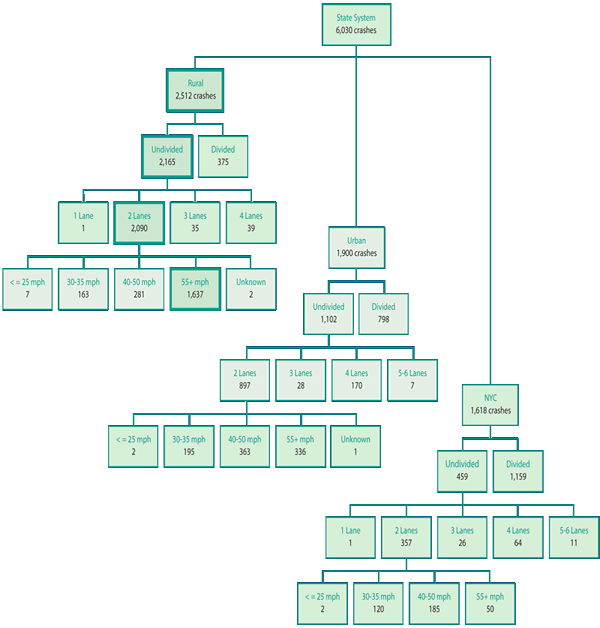
Source: New York State Department of Transportation Office of Traffic Safety and Mobility
After selecting lane departure as their focus crash type based on an analysis of crash data for the years 2007 through 2011, NYSDOT created a crash tree diagram for the state roadway system to identify the focus facility type for their systemic planning effort. The first level separates the severe roadway departure crashes into rural, urban, and New York City areas. Separating the data into three more levels (divided versus undivided, number of lanes, and speed limit) identifies the appropriate focus facility as those that are rural, undivided, and two lanes with a posted speed limit of 55 miles per hour (represented by the highlighted boxes in the diagram).
Task 3 further defines the facility types selected in the previous task by documenting the most common characteristics of the locations where crashes occurred. For example, if the previous tasks suggested a focus on road departure crashes on rural two-lane segments, then this task might indicate that these crashes were over-represented on roads with poor edges, curvilinear alignment, and volume within a specific Average Annual Daily Traffic (AADT) range. Tasks 1 and 2 relied on data typically available in the crash records system. Task 3 is the first point where road and intersection inventories are likely needed to provide additional levels of detail to support the data analysis.
The first decision to be made for this task is determining which characteristics will be evaluated—in other words, the potential risk factors for the systemic network screening. The initial characteristics are further evaluated before selecting the final characteristics that represent the risk factors. Selecting characteristics for evaluation might be based on several considerations, but it is important that they can indicate greater potential for severe focus crashes to occur. For example, the shoulder surface type might be a risk factor for roadway departure crashes in a curve but not for right angle crashes at intersections. If not certain whether a characteristic might be a suitable risk factor, then first reference safety research before evaluating that risk factor for a specific jurisdiction. Example 4 summarizes the research process the Kentucky Transportation Cabinet (KYTC) conducted to identify potential risk factors.
Roadway and Intersection Features
Traffic Volume
Other Features
| Risk Factors (Highway Safety Manual) | Compatible Highway Performance Monitoring System Attributes | Data Available | HSM – SPF Base Condition for Rural 2-Lane Road |
|---|---|---|---|
| From HSM Chapter 6 (run-off-road) | From HSM Chapter 6 (run-off-road) | From HSM Chapter 6 (run-off-road) | From HSM Chapter 6 (run-off-road) |
| Inadequate Lane Width (risk factor selected by KYTC for the systemic risk assessment) | Item 34 – lane width | Yes | 12 feet |
| Slippery Pavement | 16 attributes that are “pavement-related” Item 61 – climate zone | No | – |
| Inadequate median width | Items 35, 36 – median type, median width | Yes | – |
| Inadequate Maintenance | Item 54 – year roadway was last improved | No | – |
| Inadequate Roadway Shoulders (risk factor selected by KYTC for the systemic risk assessment) | Items 37, 38, 39 – shoulder type and width | Yes | 6 feet, paved |
| Poor Delineation (pavement markings, RPMs, chevron signs, object markers, PMDs) | None | No | Centerline Rumble Strips – None |
| Poor Visibility | None | No | Lighting – None |
| Excessive Speed (risk factor selected by KYTC for the systemic risk assessment) | None | No | Automated Speed Enforcement – None |
| From HSM Chapter 6 (vehicle rollover) | From HSM Chapter 6 (vehicle rollover) | From HSM Chapter 6 (vehicle rollover) | From HSM Chapter 6 (vehicle rollover) |
| Roadside Design (e.g. non-traversable side slopes, pavement edge dropoff) | None | Yes | Roadside Hazard Rating (RHR) = 3 |
| Pavement Design | 16 attributes that are “pavement-related” | No | – |
| From HSM Chapter 6 (fixed object) | From HSM Chapter 6 (fixed object) | From HSM Chapter 6 (fixed object) | From HSM Chapter 6 (fixed object) |
| Obstruction In or Near Roadway | None | Yes | Roadside Hazard Rating (RHR) = 3 |
| Inadequate Lighting | None | No | Lighting – None |
| Inadequate Roadway Geometry (risk factor selected by KYTC for the systemic risk assessment) | Item 43 – curves Item 45 – grades Item 46 – percent passing sight distance |
Yes (Curves) |
Horizontal curvature – None Vertical curvature – None Passing Lanes – None |
| From HSM Chapter 13 | From HSM Chapter 13 | From HSM Chapter 13 | From HSM Chapter 13 |
| Roadway Signs (a CMF) | None | Yes | – |
Source: Kentucky Transportation Cabinet
The four risk factors selected by KYTC for the systemic risk assessment are: Horizontal curve density, lane width, shoulder type, and speed limit. These are denoted by an asterisk (*) in the table.
The Kentucky Transportation Cabinet (KYTC) consulted a variety of references to assist with identifying potential risk factors. A list of potential risk factors for the focus crash type (lane departure crashes on 2-lane rural roads) was generated based on risk factors presented in Chapters 6 and 13 of the Highway Safety Manual. The table shows the potential risk factors, of which four were selected for the systemic risk assessment.
The Highway Pavement Management System (HPMS) was then reviewed to determine if their database contained an attribute related to each risk factor. The table summarizes those potential risk factors for which data were either available or collected for this systemic planning effort.
Availability of data or the ability to collect data should be part of the decision process for selecting a risk factor so candidate locations can be identified based on their characteristics. KYTC also included the base conditions for the focus facility type from the Highway Safety Manual as another source of information to assist with evaluating and selecting risk factors.
Additionally, the availability of the data element in existing databases, the ability to quickly gather data if not already available, and the applicability to the focus crash type and facility type (e.g., intersection characteristics do not need to be investigated for a systemic lane departure program) influence the selection of characteristics to review as potential risk factors. For data elements in an existing database, concerns about quality or the amount of time since the last update also may influence the decision of whether to evaluate that data element as a potential risk factor. Data that do not reflect current conditions could lead to implementing a countermeasure that is no longer appropriate or the best choice for addressing the focus crash type.
The list of potential risk factors suggests characteristics to be examined for curves, segments, and intersections. These characteristics are based on a review of published research and professional experience, many of which are inputs used by the predictive methods in the AASHTO Highway Safety Manual (HSM), and the degree to which many of these attributes might affect crash frequency is available within the HSM (AASHTO, 2010). The FHWA's Crash Modification Factor (CMF) Clearinghouse is another source for information on the relationship between location characteristics and their potential to contribute to a severe focus crash type (refer to the Appendix for more information about the CMF Clearinghouse). Table 1 shows examples of potential risk factors based on focus crash types.
After potential risk factors have been identified, they are evaluated to determine whether the characteristics exhibit a relationship to future crash potential. Only those that positively demonstrate a relationship should be selected as risk factors. Two approaches to evaluate these relationships are using descriptive statistics and reviewing characteristics using CMFs from published research.
Descriptive statistics. Descriptive statistics are used to compare the proportion of locations where the location characteristics exist with the percentage of severe crashes. For example, consider a scenario where an analysis of an intersection database identifies only 10 percent of rural unsignalized intersections are skewed, yet more than 40 percent of the severe rural unsignalized crashes occurred at skewed intersections. This indicates skew is overrepresented at rural unsignalized locations experiencing a severe crash. By extension, skew would be a good choice for one risk factor when prioritizing locations. Another option is to compare the crash density of locations exhibiting the characteristic with locations without the characteristic. Where the crash density differs between locations with and without the characteristic, then that characteristic could be used to differentiate between locations for prioritization.
Reviewing characteristics using CMFs from published research. The safety effectiveness of design features and traffic characteristics can be used instead of descriptive statistics to select risk factors. For example, intersection skew has been shown to increase crash frequency (CMF greater than 1.0) while intersection lighting has been proven to reduce crashes (CMF less than 1.0). By applying CMFs documented in safety research results, an agency could select intersection skew and the absence of intersection lighting as risk factors in lieu of local crash analysis. Furthermore, combining the findings and CMFs from research with the results of the local descriptive statistics might increase confidence in the final selection of risk factors. For example, if a county agency has a relatively small data set to evaluate risk factors for severe intersection crashes, then the descriptive statistics might not be conclusive for skew and lighting. However, CMFs for skew and lighting might reinforce or confirm the patterns seen in the local descriptive statistics, providing greater confidence that these characteristics are risk factors for a future severe crash.
Example 5 depicts the descriptive statistics application used by NYSDOT to identify curve radii as a risk factor.
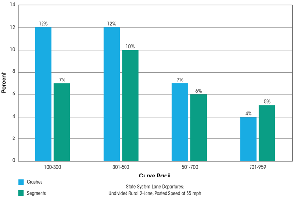
Source: New York State Department of Transportation Office of Traffic Safety and Mobility
NYSDOT chose curve radii as a potential risk factor because of the typical geometry of their focus facility – rural, undivided, two-lane roadways. When compared with all curves along the focus facility type, those segments with curve radii between 100 and 500 feet are overrepresented when compared with the proportion these curves represent of the focus facility segments. NYSDOT selected a curve radius less than 300 feet as a risk factor because the data show that 12 percent of severe crashes occurred in curves with radii less than 300 feet, while only 7 percent of all reviewed curves have radii less than 300 feet.
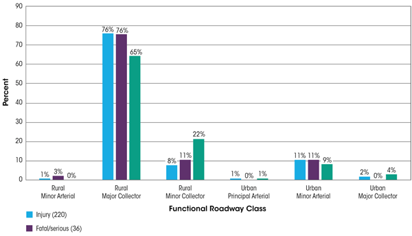
As illustrated in Example 6, Thurston County also used descriptive statistics to compare the proportion of severe curve-related roadway departure crashes on various functional classifications of roadways to the proportion of those functional classifications represented on the entire county roadway system.
How can I test a characteristic even if it is not part of an existing data set or if my data set cannot be merged with the crash data?
You could either review published CMFs or consider sampling locations for evaluation. Instead of a systemwide comparison, sample locations that have severe crashes and compare them with sampled locations without severe crashes. Video logs, online aerial imagery, or windshield surveys can be used to cost-effectively collect information on the characteristics. This also allows you to understand the magnitude of effort needed to collect the information for an entire system before choosing the characteristic as a risk factor. Does the crash tree include all severe crashes or just severe crashes for one focus crash type?
Either option is considered acceptable. If there are relatively few severe crashes, then it might be best to begin the crash tree with all crash types. However, if there are instead many severe crashes for a particular crash type, the crash tree might focus on just the one.
How many risk factors should I select?
There is no rule on how many risk factors must be selected. At a minimum, you would need two to three risk factors to differentiate between sites. Of these, the presence of one or more fatal or serious injury crashes can be viewed as a risk factor. Selecting more—up to seven to ten—requires more time to perform the screening but also helps to determine the likelihood of future crashes.
Should potential risk factors be combined during the evaluation process?
There might be occasions in which individual risk factors do not appear to be overrepresented in the crash data set. In these cases, you can perform the descriptive statistics analysis for combinations of risk factors to determine whether the related crashes are overrepresented. For example, one agency's crash data indicated that neither shoulder width nor shoulder surface type were risk factors for road departure crashes in horizontal curves. Engineering judgment suggested further analysis was required. Combining the data associated with these two risk factors revealed that severe crashes were found to be overrepresented in curves that had either narrow gravel shoulders or wide paved shoulders (which were also high volume corridors).
Can you still identify risk factors if you do not have local Average Annual Daily Traffic (AADT) information?
Unless the range of volumes across the network being evaluated is very narrow, it is generally desirable to consider AADT as a risk factor. Since higher volume may not always relate to higher risk, agencies should conduct a descriptive statistics analysis to identify the range of volumes with the highest risk for potential crashes. If traffic volume data are not available to perform a descriptive statistics analysis for AADT, then agencies are strongly encouraged to do a qualitative assessment (e.g., categorizing AADT as high, medium, or low to evaluate if AADT is indeed an important risk factor).
Source: Thurston County, Washington, Department of Public Works
Thurston County compared the proportion of severe curve-related roadway departure crashes on various functional classifications of roadways to the proportion those functional classifications represent of the entire County roadway system. The data show that the focus crash type occurs on roadways with a Rural Major Collector functional classification in a greater proportion than this roadway type represents for the County system. Based on this descriptive statistics analysis, Thurston County chose Rural Major Collector functional classification as a risk factor.
Completing the first step of the systemic safety planning process provides an understanding of the focus crash types, focus facilities, and risk factors that represent the core of the developing systemic safety program. This information informs the risk assessment process in the next step of the systemic safety planning process.
Q: Is there a minimum number of crashes on a system that is considered necessary to provide credible results?
A: That will depend on the data and your starting point. For example, you might choose to begin the crash tree with only data for your jurisdiction or subregion instead of statewide, thereby eliminating one or more levels from the diagram.
Typically, most information used at this step will be reported by the officer on the crash report. Therefore, use whatever data are considered reliable and relevant for the focus crash type, but be careful not to create too many levels or the number of crashes will become small and the patterns difficult to identify.
Q: What if my data system cannot provide the ideal level of data?
A: The process can be modified to work with the data that are available, but the analysis outcomes might not be as detailed as desired. If existing road and intersection data are limited, then video logs, aerial imagery, or field visits might supply useful information. However, these data collection efforts would require additional investment to synthesize the data into a usable format.
Q: What if my jurisdiction has developing areas for which land use patterns are changing and traffic volumes are growing?
A: The process ideally relies on the most recent crash, volume, and roadway data available. If these data do not reflect current conditions, then the process might still be applicable, depending upon the crash type and countermeasure selection. For example, if traffic volumes are increasing on a facility but access is not changing, then the risk rating and the countermeasure selection might still be appropriate. A possible exception is when the type of countermeasure assigned for very low-volume facilities is different than moderate- and high-volume facilities. In this case, you should consider the countermeasures identified for moderate- and high-volume areas based on the volume growth rate. On the other hand, if the growth in the area is resulting in modified land use patterns, access density, and roadway cross-section, then the countermeasures derived from the process might not be as useful for preventing crashes given the current volumes and roadway configurations. In these situations, you should critically review the analysis to determine whether the risk rating and selected countermeasure will apply to conditions in the near future.
The objective of the second step in the systemic safety planning process is to develop a prioritized list of potential locations on the roadway system (e.g., segments, curves, intersections) that could benefit from systemic safety improvement projects. The results of this step answers the question Are all elements of my system equally at risk for the focus crash types or are some more at risk than others?
The process to screen and prioritize candidate locations evaluates specific sites (i.e., individual segments, curves, and intersections) at the micro-level. The tasks in this step involve reviewing all elements from the focus facility types and assigning a level of risk to each element. Risk is inferred from the presence of crashes and risk factors, which are roadway and traffic features commonly associated with the locations where the focus crash types occur.
The screening and prioritization process requires two primary types of data. The first type is site-specific crash information, including severity, type, and any contributing factors relevant to the focus crash types and facility types. The second data type is the basic features of the road system, especially geometric or traffic elements selected as risk factors in the previous step of the systemic safety planning process. This information is available in from variety of sources, including electronic databases of roadway features and traffic characteristics, archives of as-built plans, aerial photography and street views, video logs, traffic control device inventories, and traffic flow maps.
As Figure 5 illustrates, screening and prioritizing candidate locations involves three tasks: selecting the locations or elements of the roadway system to review, verifying selected crash risk factors, and prioritizing these elements based on the presence of the risk factors at each location. In this process, the more risk factors present infers a higher priority as a candidate for safety investment.
FIGURE 5. Systemic Safety Planning Process: Tasks to Screen and Prioritize Candidate Locations
Task 1 identifies the elements from the focus facility types, which represent the locations where the focus crash types tend to occur. For spot-based applications such as curves and intersections, all relevant locations are identified first. For segment applications, corridors are split into elements with consistent design (i.e., cross-section) to establish homogeneous segments. Additionally, the segment elements should have uniform traffic and design characteristics whenever possible, especially with respect to the selected risk factors. Homogeneous segments allow for consistent application of risk assessment and the same countermeasure to be selected for the entire element. For example, a rural two-lane corridor might be divided into segments extending from the limits of one small rural community to the limits of the next community. The Highway Safety Improvement Program Manual provides additional guidance for identifying network elements (FHWA, 2010).
After identifying the network elements to analyze, assemble the information in a format useful for conducting the risk assessment and documenting the results. Refer to the Minnesota Department of Transportation Case Study for an illustration of how to document identified network elements.
What other data should I collect when reviewing locations for risk factors?
When examining specific locations, in addition to collecting information about the risk factors, you should also collect information that might impact countermeasure selection. For example, if the focus crash type is lane departure on rural two-lane highways, data related to shoulder width, shoulder surface type, and lane width can help select countermeasures, such as shoulder rumble strips, edgeline rumble strips, or enhanced edgeline markings.
You might not be able to gather every possible piece of data that impacts the project type selection, especially the first time going through a systemic analysis. However, the point is to think this through to prevent (or at least minimize) having to scan the part of the system selected for treatment a second time.
In Task 2, agencies assess the risk of the systems and specific locations selected for analysis. The purpose of this assessment is to identify and document roadway and traffic characteristics pertaining to the selected risk factors, as well as total crash history, if applicable, for each location. For purposes of the Systemic Tool, the term "risk assessment" means the effort to collect the roadway/traffic data and to characterize the potential for a severe focus crash to occur at a given location or along a given segment of roadway based on certain characteristics present at these network elements.
The roadway and traffic characteristics could be available in a database format or can be collected as part of a field review of the road system. Roadway and traffic characteristics might also be collected in a virtual environment with field confirmation, as appropriate. Agencies with experience developing systemic approaches have found that roadway features can be documented in the office using video logs, aerial photography, and traffic volume data bases. Also, local agencies can provide some basic information about design features and traffic control devices.
The process to document the presence of a risk factor at a given network element involves recording if the risk factor is present or not. Presence can be indicated with a "1" or an asterisk or some other identifier that can be tabulated. Summing the number of risk factors present provides the ability to compare and prioritize network elements. The MnDOT Case Study at the end of this section provides an example of the documentation produced for a risk assessment.
After identifying and documenting the network elements for the prioritization process, consider if the selected risk factors are feasible for a systemwide analysis. A risk factor is not useful to prioritize locations if it is present at every location on the focus facility. For example, speed limit may need to be removed as a risk factor if it is the same for all roadway segments identified for the screening process. Also, curve radii may not be an appropriate risk factor if every curve on the focus facility type has the same radius. After considering, remove or add risk factors if necessary. This revision may be necessary if risk factors were selected using CMFs or a sample of locations on the focus facility. The MnDOT Case Study contains an example of the determination of risk factor feasibility.
Task 3 generates the prioritized lists of segments, horizontal curves, and intersections based on the presence of the selected risk factors—the more risk factors present, the greater the potential for the focus crash type and the higher the priority as a candidate for safety investment. Systemic analysis approaches might weigh risk factors equally, which simply means the more risk factors present, the higher the location's priority. However, risk factors also can be given relative weights. In this case, particular risk factors—if found to have a stronger association with locations where severe focus crashes occurred—can be given larger weights. The values for relative weights may be high/medium/low or based on integers that infer a higher level of confidence in the weights. Example 7 illustrates how Thurston County weighted their selected risk factors based on their level of confidence in the data representing that risk factor.
Agencies can adjust the thresholds (the number of risk factors present or a weighted value) used to identify high-priority candidates based on the level of funding anticipated for implementation. To set the threshold, agencies should identify more candidate locations than can be implemented in a given year. There are two reasons for this. First, the effort creates a backlog or shelf life for the analysis so that it does not have to be completed annually. Second, locations might drop off the list as a result of field conditions or where additional time or funding is needed to implement the selected countermeasure. Having identified more candidates than can be implemented in one year provides flexibility to ensure all available funding can be allocated to priority projects. The MnDOT Case Study contains an example illustration of how risk assessment results are useful to establish a threshold for candidate locations.
| Category | Higher Confidence | Lower Confidence |
|---|---|---|
| Crash Over-representation | > 10% | ≤10% |
| Crash Total | ≥ 30% | < 30% |
| Weight | 1 point | 0.5 point |
| ID | Risk Factor | 1 Point Range | ½ Point Range |
|---|---|---|---|
| 01 | Federal/Functional Classification | Major Rural Collector | Urban Minor Arterial |
| 02 | Intersection | Yes | – |
| 03 | Vertical Curves | – | Yes |
| 04 | Visual Trap | – | Yes |
| 05 | Edge Risk Assessment Rating = 3 | Yes | – |
| 06 | Paved Shoulder Width | > 4 feet | – |
| 07 | Average Daily Traffic | 3,000-7,500 | 0-1,500 |
| 08 | Speed Differential (native shoulders) | – | 0 to 5 mph Width < 4 feet at 25 mph |
| 09 | Speed Differential (paved shoulders) | – | 20 mph |
| 10 | Type of Advance Warning Sign | – | W1-5 |
In a systemic review of road departure crashes on horizontal curves, Thurston County prioritized their selected risk factors by weighting them based on their level of confidence in the data representing that risk factor. Using the results of the descriptive statistics analysis performed on the potential risk factors, those factors present in at least 30 percent of the severe crashes and overrepresented by at least 10 percentage points (when comparing the proportion of all locations with the proportion of severe crash locations) were considered to have a high confidence and were assigned a weighted value of one point in the risk assessment process. Of the risk factors that were selected but did not meet these criteria, Thurston County had a lower confidence in them and each was assigned a relative weight of one-half point. The Risk Factor Weights table summarizes these criteria. This prioritization was used as a guideline, not a strict standard, for assigning weights to risk factors. The Risk Factor Prioritization Results table summarizes the results of the weighting process for the ten risk factors selected by Thurston County.
The final result of Task 3 is a prioritized list of focus facility elements that represents the locations with the greatest potential for the focus crash type to occur. At a minimum, the list includes information about the element location and the risk assessment score. Example 8 shows the eight horizontal curves on the Thurston County Rural Major Collector system that have the highest risk scores and, therefore, represent the highest priority locations for systemic safety improvements. This list shows the value of systemic safety planning—more than half of these locations with risk factors present do not have a documented severe crash. However, the risk assessment indicates these locations have common characteristics with locations where severe crashes have occurred and, therefore, have the potential for a future severe crash.
The outcome of this step is a risk assessment and ranking of the focus facility elements. The elements of the focus facilities carried forward to the next phase represent the locations with greatest potential for safety improvement.
Q: What if I do not have enough data to either document the characteristics of locations with crashes or to conduct the risk assessment of focus facilities?
A: The key objective of this step is to determine whether one part of a system is more at risk than another, which might require only one or two risk factors which could be based on data readily available, such as number of lanes or roadway curvature.
Q: How do I know if the characteristics I select really represent an increased level of risk?
A: Three keys to improve the success of your program include (1) be evidence driven [descriptive statistics and CMFs] in your selection of risk factors and consistent in their application, (2) exercise your judgment and conduct annual follow-up evaluations to see how the process is working, and (3) make adjustments if and when necessary.
Q: How many locations should I select in my initial prioritized list?
A: You can determine exactly how many locations to select for your initial prioritized list using factors such as anticipated funding amount and implementation goals. If your initial threshold identifies too few locations, then add locations in their established priority order until the target funding level is reached.
These eight horizontal curves on the Thurston County Rural Major Collector system have the highest risk scores and, therefore, represent the highest priority locations for systemic safety improvements. This list shows the value of systemic safety planning – more than half of these locations with risk factors present do not have a documented severe crash.
| Curve ID | Road Name | Scoring | 5-year Crash Rate | Fatal or Serious Crash |
|---|---|---|---|---|
| 182 | Hawks Prairie Road NE | 6.5 | 1.2 | Yes |
| 194 | Boston Harbor Road NE | 6.0 | 1.1 | No |
| 143 | Delphi Road NW | 6.0 | 0.9 | No |
| 203 | Johnson Point Road NE | 5.5 | 0.4 | No |
| 202 | South Bay Road NE | 5.5 | 0.2 | No |
| 136 | Waddell Creek Road SW | 5.5 | 10.3 | Yes |
| 238 | Morris Road SE | 5.5 | 2.6 | Yes |
| 58 | Bald Hill Road SE | 5.5 | 7.2 | No |
Source: Thurston County, Washington, Department of Public Works
The objective of the third step in the systemic safety planning process is to assemble a small number of low-cost, highly effective countermeasures to be considered for project development at candidate locations. The countermeasures are selected based on research related to the systemwide data analysis results from the first step (Identify Focus Crash Types and Risk Factors), and specific jurisdictional experience, policies, and practices regarding potential countermeasures.
The National Cooperative Highway Research Program (NCHRP) Report 500 series is a suggested source of information for assembling the initial list of safety countermeasures (TRB, Various). These 24 volumes provide an extensive list of countermeasures for each of AASHTO's safety emphasis areas plus they provide insight about implementation costs. Recent countermeasure effectiveness information is available in the HSM and the CMF Clearinghouse. The National Highway Safety Traffic Administration's (NHTSA's) Countermeasures That Work report provides effectiveness information about behavioral countermeasures (NHTSA, 2013). These resources provide information about the expected effectiveness of the countermeasures, and documentation of implementation and maintenance costs. Other information needed to support countermeasure selection is gathered from the crash, roadway, and traffic data assembled in the previous two steps.
The information documented for the countermeasures might indicate whether the countermeasure is proven or tried, the expected safety effectiveness of the countermeasure, estimated implementation and maintenance costs, and consistency with agency policies and practices. In addition to assisting with countermeasure selection, this information is useful to the safety planning process because it provides:
FIGURE 6. Systemic Safety Planning Process: Tasks to Select Countermeasures
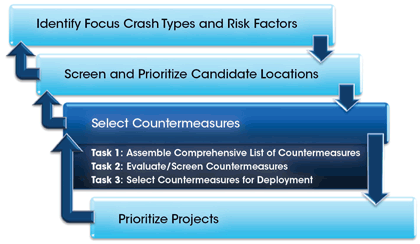
Countermeasure selection involves assembling a comprehensive list of potential countermeasures and evaluating each countermeasure to determine a select few most appropriate for systemic deployment. Figure 6 shows the three primary tasks conducted to define the safety countermeasures for implementation at the candidate locations.
Task 1 involves assembling a comprehensive list of the safety countermeasures associated with each focus crash type. The list is assembled after reviewing the latest research and other available information (e.g., agency experience or engineering judgment) to identify those countermeasures with the greatest potential to address the focus crash types. As previously mentioned, the NCHRP Report 500 series, HSM, and CMF Clearinghouse are suggested starting points for the research effort. A state SHSP or other local safety plans also might include countermeasures already defined for particular focus crash types. Other resources, such as FHWA's illustrated guide sheets for 77 intersection countermeasures, may be used for developing the initial list of countermeasures (FHWA, Office of Safety). An agency's existing maintenance program could also be a source for identifying potential countermeasures. For example, a countermeasure could be to replace missing or damaged traffic signs with signs that meet current retroreflectivity standards. The MnDOT Case Study provides an illustration of the process to assemble a comprehensive list of countermeasures.
The second task in the countermeasure selection process is to evaluate and screen the initial list of countermeasures based on documented safety effectiveness at reducing the focus crashes, implementation and maintenance costs, and consistency with the agency's policies, practices, and experiences. Implementing countermeasures that are proven to be effective at reducing crashes provides agencies the highest possible level of confidence that their investment will have a positive outcome—a reduction in the focus crashes. The HSM and the CMF Clearinghouse provide the most current information about countermeasure effectiveness. Evaluation results from previous countermeasure implementation efforts (discussed in Element 3 of the Systemic Safety Project Selection Tool) offer additional critical information for evaluating and selecting future countermeasures. The key is to follow the evidence and select the countermeasures with the greatest potential to address the focus crash type not just at a single location, but across the prioritized focus facility elements.
Should I seek input from others when screening countermeasures?
To generate awareness of the systemic safety planning process and support among safety partners, you may conduct safety workshops during this task. Agency staff representing Engineering, Enforcement, Emergency Medical Services, and Driver Education could participate in a day-long workshop focused on sharing information about the process to select target crash types, and then discussing and prioritizing safety countermeasures. Also, within the engineering group, experts beyond just traffic and safety (e.g., construction, maintenance, public affairs representatives) should be involved.
Is safety effectiveness the only issue to consider when evaluating countermeasures?
An equally important consideration in the process of screening the countermeasures is the implementation and maintenance cost. The systemic approach is focused on mitigating types of crashes that are widely scattered across a roadway system. The key to addressing low crash densities is implementing low-cost countermeasures, so that resources are adequate to widely deploy them across a system. Furthermore, policies and practices might limit the ability to use some countermeasures such as automated enforcement. The practical ability to implement a countermeasure equally influences the screening process.
Is there an optimum number of countermeasures for my agency's short list?
Not really—too few countermeasures can limit flexibility to address the various conditions and constraints that are typical across a roadway system. Too many countermeasures can make project development more challenging and follow-up evaluations more difficult (too few samples of any one countermeasure to provide statistical reliability).
Why would I want to remove countermeasures from the list?
In many cases, there are simply too many potential countermeasures to discuss in any meaningful way at a stakeholder meeting or workshop. There are going to be some countermeasures that are just not consistent with an agency's practices and should be removed before investing time and energy to discuss further.
Are the CMFs developed for specific high-crash locations applicable to a systemic implementation?
While CMFs in the CMF Clearinghouse present the best information available to date, it is important to recognize that most CMFs were developed from before-after studies conducted when the countermeasure was implemented at a high-crash location. However, it is unknown whether the same results will be achieved when implementing these countermeasures on a systemic basis. Because systemic countermeasures are deployed at some locations with no crash history, it is possible that a systemic application of a countermeasure may not achieve as high of an average percentage reduction in crashes as a high-crash location. Therefore, you are encouraged to conduct follow-up evaluations as described in Element 3 to determine the true effect of implementing safety countermeasures.
The screening process should consider maintenance requirements for the countermeasures because a countermeasure cannot perpetually provide the potential for crash reduction if it is not maintained or replaced when necessary. Thus, agencies should consider their ability to perform and fund routine maintenance of countermeasures implemented through a systemic deployment program. A countermeasure is likely not going to be a viable improvement and should be removed during the screening process if it will not be maintained. The MnDOT Case Study provides an illustration of how to evaluate and screen countermeasures.
Agencies can also screen potential countermeasures by performing a benefit-cost analysis of various countermeasures applicable for a typical section that represents the focus facility type. A spreadsheet tool is useful to automate the benefit-cost ratio calculations. Example 9 illustrates the benefit-cost analysis used to identify countermeasures for roadway departure crashes on bridges in Salem County, New Jersey. When performed in this manner, a benefit-cost analysis can help to determine the most cost-effective way to spend the funding allocated to systemic improvements.
The result of the countermeasure screening process is the selection of one or more countermeasures for each focus crash type. This short list would include primarily low-cost countermeasures, along with a few higher-cost countermeasures. Agencies use this list of countermeasures to develop safety projects at specific locations across their roadway system. Although an agency might choose to deploy one particular countermeasure, there might also be locations where that countermeasure is not an ideal choice. As a result, having alternatives to choose from provides flexibility and acknowledges that all candidate locations in a system are not the same. Additionally, including alternative countermeasures offers an opportunity to incorporate a few higher-cost countermeasures proven to significantly reduce crashes. Agencies should use these higher-cost countermeasures in a limited number of circumstances and only in situations that might not be effectively addressed by the low-cost countermeasures in the short list. The high-priority locations identified in the second step (Screen and Prioritize Candidate Locations) also might influence the final countermeasure selection, which is why it is important to identify a range of countermeasures appropriate for the range of high-priority sites selected for project development. The final selection represents the highest-priority countermeasures that agencies will maintain for safety investment, based on expected crash reductions and estimated implementation costs. The MnDOT Case Study provides an illustration of how to select countermeasures for deployment.
An outcome of this step is documentation of the countermeasures, which will be used in future program evaluation. The primary outcome of this step is a short list composed mainly of effective, low-cost countermeasures and a few higher-cost countermeasures for each focus crash type. These countermeasures then become the focus of the safety project development efforts that are described in the next step of the systemic safety planning process.
| Step | Year – 2012 (Years in Service Life – 0)/Annual Average Daily Traffic – 1,400 | Year – 2013 (Years in Service Life – 1)/Annual Average Daily Traffic – 1,428 | Year – 2014 (Years in Service Life – 2)/Annual Average Daily Traffic – 1,457 | Year – 2015 (Years in Service Life – 3)/Annual Average Daily Traffic – 1,486 | Total Number of Crashes | Total Benefit | |
|---|---|---|---|---|---|---|---|
| Step 1 WITHOUT Countermeasure Number of Crashes (Expected Before) | Total | 0.0090 | 0.0092 | 0.0094 | 0.0097 | 0.0283 | – |
| Step 1 WITHOUT Countermeasure Number of Crashes (Expected Before) | Fatal and Injury | 0.0029 | 0.0030 | 0.0030 | 0.0031 | 0.0091 | – |
| Step 1 WITHOUT Countermeasure Number of Crashes (Expected Before) | Property Damage Only | 0.0061 | 0.0063 | 0.0064 | 0.0066 | 0.0092 | – |
| Step 2 WITH Countermeasure Number of Crashes (Expected After) | Total | – | 0.0073 | 0.0075 | 0.0076 | 0.0224 | – |
| Step 2 WITH Countermeasure Number of Crashes (Expected After) | Fatal and Injury | – | 0.0016 | 0.0016 | 0.0016 | 0.0048 | – |
| Step 2 WITH Countermeasure Number of Crashes (Expected After) | Property Damage Only | – | 0.0063 | 0.0064 | 0.0066 | 0.0192 | – |
| Step 3 Change in Number of Crashes (Expected) | Total | – | 0.0019 | 0.0020 | 0.0020 | 0.0059 | – |
| Step 3 Change in Number of Crashes (Expected) | Fatal and Injury | – | 0.0014 | 0.0014 | 0.0015 | 0.0043 | – |
| Step 3 Change in Number of Crashes (Expected) | Property Damage Only | – | 0.0 | 0.0 | 0.0 | 0.0 | – |
| Step 4 Benefit and Maintenance Calculations | Change in Number of Crashes (Fatal and Injury) | – | 0.001391 | 0.0 | 0.0 | – | – |
| Step 4 Benefit and Maintenance Calculations | Fatal and Injury Crash Cost | – | $158,200 | $158,200 | $158,200 | – | – |
| Step 4 Benefit and Maintenance Calculations | Annual Maintenance Cost (Fatal and Injury) | – | $220 | $220 | $230 | – | – |
| Step 4 Benefit and Maintenance Calculations | Change in Number of Crashes (Property Damage Only) | – | 0.0 | 0.0 | 0.0 | – | – |
| Step 4 Benefit and Maintenance Calculations | Property Damage Only Crash Cost | – | $7,400 | $7,400 | $7,400 | – | – |
| Step 4 Benefit and Maintenance Calculations | Annual Maintenance Cost (Property Damage Only) | – | $0 | $0 | $0 | – | – |
| Step 4 Benefit and Maintenance Calculations | Annual Maintenance Cost (Total) | – | $220 | $220 | $230 | – | – |
| Step 5 Present Value Calculation | Present Value | – | $212 | $203 | $204 | – | $619 |
| Category | Benefit (Net Present Value) |
Cost | Benefit/ Cost Ratio |
|---|---|---|---|
| Guiderail | $1,685.55 | $4,200 | 0.401 |
| Rumble Strips | $619.41 | $126 | 4.915 |
| Rumble Stripes | $0.00 | $268 | 0.0000 |
| Pavement Markings | $813.67 | $284 | 2.865 |
| Pavement Resurfacing | $162.22 | $3,675 | 0.044 |
| High-Friction Surfacing | $1,171.71 | $1,386 | 1.278 |
Source: Rutgers CAIT Transportation Safety Resource Center
The Rutgers Center for Advanced Infrastructure and Transportation (CAIT) Transportation Safety Resource Center performed a systemic safety analysis for Salem County, New Jersey, to develop a prioritized list of HSIP-eligible projects. CAIT conducted a cost-benefit analysis of potential countermeasures selected based on identified risk factors. CAIT used safety performance functions (from the HSM predictive method procedures) and crash modification factors (from the CMF Clearinghouse) to estimate the difference between the expected number of crashes with and without the countermeasure (the benefit of implementing the countermeasure). After calculating the net present value of the implementation and maintenance costs, the automated process estimated the benefit-cost ratio of each countermeasure. The resultant prioritization of the countermeasures was used to create safety projects for sites with particular combinations of lane width and traffic volume.
The objective of the fourth and final step in the systemic safety planning process is to identify and develop a list of high-priority safety improvement projects for implementation. This process considers the prioritized at-risk locations identified in the second step (Screen and Prioritize Candidate Locations) and applies the most appropriate countermeasures from the list developed in the third step (Select Countermeasures) to develop a list of high-priority safety improvement projects. For the purposes of the Systemic Tool, the term projects includes dedicated safety projects as well as safety improvements implemented as one component of a traditional construction or maintenance project (e.g., resurfacing) or as part of routine maintenance efforts.
The information needed to support the project prioritization process includes a basic understanding of an agency's priorities, practices, and policies as they relate to project and program development. This understanding is especially important to ensure the countermeasures identified in this step are only included in projects for areas where they fit with local practices for installation and maintenance. In addition, defining specific safety projects requires current information about countermeasure implementation costs and estimated effectiveness.
Prioritizing projects involves developing a decision process so that selected countermeasures can be consistently assigned to projects for the prioritized focus facility elements identified in the second step. This fourth and final step results in a prioritized implementation order for safety projects. Figure 7 shows the three basic tasks conducted to prioritize systemic safety projects.
FIGURE 7. Systemic Safety Planning Process: Tasks to Prioritize Projects
Creating a decision process for each focus crash type provides a means to consistently assign countermeasures to focus facility locations. A decision process is simply a set of criteria that considers issues such as volume, environment, adjacent land use, or cross-section, and uses them to identify the appropriate countermeasure for high-priority locations. An important distinction of the systemic safety planning process is that the decision-making process does not just identify the most appropriate countermeasure for each location (like when addressing hot spots), it also considers multiple locations with similar crash and risk characteristics to select preferred one or more countermeasures suitable and affordable for widespread implementation. Alternative countermeasures, and the criteria for deploying each countermeasure, might consider typical variations in site conditions.
For example, urban intersection and rural road departure systemic safety programs address uniquely different problems. Therefore, each program needs countermeasures specific to the problem and different decision processes for selecting the final countermeasure. Additionally, programs addressing similar issues on different facility types (e.g., road departure on rural divided expressways versus two-lane highways) might have some of the same countermeasures, but the criteria and thresholds for selecting the countermeasures might be completely different. An agency can develop a process recognizing that no single countermeasure is likely to be best for every location due to the variety of features and characteristics that are encountered along a roadway system. The MnDOT Case Study illustrates a decision tree created to select countermeasures.
Shoulder rumble strips may be the preferred countermeasure for addressing rural road departure crashes that happen due to driver inattention. Factors that might influence the actual decision to implement shoulder rumble strips at any given location include the shoulder surface type and width, lane width, and the presence of adjacent residential development. These factors could point to selecting an alternative countermeasure, such as edge-line rumble strips (also known as rumble stripes), if there is no paved shoulder and no noise concerns. An enhanced edgeline using a wider edgeline or wet-reflective material might be considered in the case of either really low-volume, narrow lanes with no paved shoulder or due to noise concerns in areas with residential development.
Criteria should also consider when any higher-cost alternatives are selected. In this same scenario, a higher-cost alternative could be paving shoulders with adding rumble strips. Criteria might suggest this as the preferred project if the gravel shoulder is sufficiently wide and the countermeasure is appropriate for the site conditions and agency practices. Other criteria for choosing a higher-cost countermeasure could include high volumes, a relative high frequency of severe road departure crashes, or a curvilinear alignment where recovery area outside the edgeline is viewed as important.
The next task in the project prioritization process is to apply the decision process to identify one or more specific countermeasure for each candidate locations selected for safety investment. Safety projects are developed by providing a detailed site description (e.g., route number, mile point, intersecting roadway, and segment termini), identifying the specific countermeasure selected, estimating the implementation cost, and summarizing how the site scored with the risk factors. After the countermeasures for safety investments are selected, agencies can then decide how to most efficiently bundle projects into a design package for contract letting. The MnDOT Case Study shows an example of the documentation produced during the process to develop a safety project.
Lastly, projects are prioritized for implementation by considering factors such as funding, other programmed projects, time to develop project plans, expected crash reduction, amount of public outreach needed, and environmental and right-of-way constraints. The prioritized list of locations infers a particular order based on the number of risk factors present at a given location. However, other factors often influence the ability to let a specific project. For example, a project might need to be included in an established capital improvement program or coordinated with other projects/programs. The next chapter presents a case study that illustrates how MnDOT applied the systemic safety planning process to develop prioritized projects for deployment on the county roadway network throughout the state.
The outcome for this step is development of a safety project for each identified at-risk candidate location along a roadway system. The roll-up of the prioritized projects produces the systemic safety program for the city, county, district, region, or state. This final step completes the systemic safety planning process, which is Element 1 of the Systemic Safety Project Selection Tool.
Q: I have selected a preferred countermeasure to mitigate the focus crash type and now I find that I cannot implement this countermeasure at a particular location (e.g., due to a lack of support by maintenance crews, complaints by residents, lack of support by local politicians, geometric constraints). What do I do?
A: You should have multiple countermeasures identified, which will provide flexibility to adapt to the many constraints and/or features that are typical across roadway systems. The decision process should account for such issues by providing alternative countermeasures.
Q: If I have a list of suggested safety projects in my possession and I choose not to implement some, either immediately or ever, am I at risk from a tort liability perspective?
A: This question comes up regularly in conversations with local agencies. Agencies should have clear documentation of the process used to identify and prioritize safety investments. Tort law in a number of states provides agencies with discretionary immunity related to decisions about the allocation of resources. In addition, federal law (23 U.S.C. 409) and a U.S. Supreme Court case (Pierce County, Washington v. Guillen) protects agencies participating in statewide safety planning efforts that support the HSIP by shielding the outcomes of those efforts from plaintiff's attorneys; the information generated (e.g., data, lists of at-risk facilities, lists of suggested projects) is not discoverable and cannot be used against an agency in tort cases. Agencies should seek legal counsel to determine the extent of protection provided by these Federal statutes.
Q: The process has identified more projects than there are funds available—is this a problem?
A: No, systemic safety planning is not expected to be fiscally constrained. It is desirable to identify more projects than could be implemented in a single year because funding agencies will have a multiyear backlog of high-priority projects (and will not need to perform annual analysis updates). A good target would be to assume a of 3- to 5-year shelf life for the results of the analytical process, after which the process would be updated.
Q: Can I use HSIP funds to supplement regular funding sources for reconstruction?
A: Federal regulation (23 CFR 924.5) states that improvements to safety features that are routinely provided as part of a broader federal-aid project should be funded from the same source as the broader project. States should address the full scope of their safety needs and opportunities on all roadway categories by using all available funding sources. For example, if an improvement project identified through the HSIP planning and programming process encompasses an area identified through the systemic planning process a location for safety improvements, it makes logical sense to combine the two efforts to reduce the cost of two projects (less administration, only one mobilization cost, etc.).
Q: My high-priority segments, curves, and intersections are listed in a very specific rank order. Do the suggested safety projects need to be implemented in that exact order?
A: No, the prioritization process results in a rank ordering of the system based on a comparison to the adopted risk factors. However, a variety of factors (i.e. cost effectiveness) likely will enter into an agency's decision as to how projects will fit into their capital improvement program. Agencies would benefit from a systemic prioritization process that considers these other factors to the extent feasible.
The following case study illustrates how the Minnesota DOT applied the systemic safety planning process as part of a statewide effort to develop county road safety plans for each of their 87 counties. The focus crash types were severe lane departure crashes on rural segments and curves, severe right-angle crashes at rural thru-stop and urban signalized intersections, and severe pedestrian crashes in urban areas. The FHWA's HSIP Noteworthy Practice Series provides information about this effort (FHWA, Office of Safety). The FHWA's Developing Safety Plans: A Manual for Local Rural Road Owners provides guidance for developing local road safety plans (FHWA, 2012). The case study provides illustrations of each successive task of the systemic safety planning process, using the same data set throughout. Each illustration describes the purpose, provides a description, and typically shows example data and analysis results.
Identify Focus Crash Types and Risk Factors – Task 1: Select Focus Crash Types – Crash Data for All Public Roads
| Emphasis Area | Statewide Percentage | Statewide – State System (Percentage) | Statewide – State System | Statewide – County System (Percentage) | Statewide – County System | Statewide – City, Township, & Other System (Percentage) | Statewide – City, Township, & Other System |
|---|---|---|---|---|---|---|---|
| Total Fatal and Serious Injury Crashes | 8,300 | – | 2,998 | – | 3,379 | – | 1,923 |
| Drivers – Young drivers (under 21) | 24% (Top 5 Emphasis Area by Jurisdiction) | 21% | 638 | 25% (Top 5 Emphasis Area by Jurisdiction) | 839 (Top 5 Emphasis Area by Jurisdiction) | 28% (Top 5 Emphasis Area by Jurisdiction) | 539 (Top 5 Emphasis Area by Jurisdiction) |
| Drivers – Unlicensed drivers | 8% | 8% | 251 | 7% | 237 | 9% | 164 |
| Drivers – Older drivers (over 64) | 14% | 18% | 527 | 13% | 429 | 11% | 206 |
| Drivers – Aggressive driving and speeding-related | 20% | 20% | 606 | 20% | 661 | 22% (Top 5 Emphasis Area by Jurisdiction) | 432 (Top 5 Emphasis Area by Jurisdiction) |
| Drivers – Drug and alcohol-related | 26% (Top 5 Emphasis Area by Jurisdiction) | 23% (Top 5 Emphasis Area by Jurisdiction) | 680 (Top 5 Emphasis Area by Jurisdiction) | 26% (Top 5 Emphasis Area by Jurisdiction) | 949 (Top 5 Emphasis Area by Jurisdiction) | 26% (Top 5 Emphasis Area by Jurisdiction) | 497 (Top 5 Emphasis Area by Jurisdiction) |
| Drivers – Inattentive, distracted, asleep drivers | 20% | 23% (Top 5 Emphasis Area by Jurisdiction) | 693 (Top 5 Emphasis Area by Jurisdiction) | 19% | 638 | 16% | 300 |
| Occupants – Unbelted vehicle occupants | 25% (Top 5 Emphasis Area by Jurisdiction) | 26% (Top 5 Emphasis Area by Jurisdiction) | 782 (Top 5 Emphasis Area by Jurisdiction) | 26% (Top 5 Emphasis Area by Jurisdiction) | 872 (Top 5 Emphasis Area by Jurisdiction) | 21% | 400 |
| Special Users – Pedestrian crashes | 8% | 6% | 180 | 7% | 222 | 15% | 291 |
| Special Users – Bicycle crashes | 4% | 2% | 54 | 3% | 113 | 8% | 157 |
| Vehicles – Motorcycle crashes | 16% | 14% | 416 | 17% | 591 | 15% | 293 |
| Vehicles – Heavy vehicle crashes | 10% | 15% | 456 | 7% | 249 | 6% | 114 |
| Highways – Train-vehicle crashes | 0% | 0% | 1 | 0% | 7 | 1% | 17 |
| Highways – Road departure crashes | 28% (Top 5 Emphasis Area by Jurisdiction) | 27% (Top 5 Emphasis Area by Jurisdiction) | 807 (Top 5 Emphasis Area by Jurisdiction) | 32% (Top 5 Emphasis Area by Jurisdiction) | 1,090 (Top 5 Emphasis Area by Jurisdiction) | 22% (Top 5 Emphasis Area by Jurisdiction) | 420 (Top 5 Emphasis Area by Jurisdiction) |
| Highways – Intersection crashes | 42% (Top 5 Emphasis Area by Jurisdiction) | 40% (Top 5 Emphasis Area by Jurisdiction) | 1,212 (Top 5 Emphasis Area by Jurisdiction) | 42% (Top 5 Emphasis Area by Jurisdiction) | 1,422 (Top 5 Emphasis Area by Jurisdiction) | 45% (Top 5 Emphasis Area by Jurisdiction) | 871 (Top 5 Emphasis Area by Jurisdiction) |
| Highways – Head-on and Sideswipe (opposite) crashes | 15% | 17% | 51 | 14% | 489 | 14% | 263 |
| Highways – Work zone crashes | 2% | 2% | 69 | 1% | 38 | 1% | 20 |
Note: Numbers are not additive, as one crash may involve a young driver at an intersection. The numbers represent severe crashes (Fatal and A-type Injury crashes).
Source: Department of Public Safety Crash Data Records, 2006 to 2010
Identify the high-priority emphasis area – categories of severe crashes that represent the greatest opportunities for reduction.
Identify Focus Crash Types and Risk Factors – Task 2: Select Focus Facilities – Crash Tree for All Public Roads
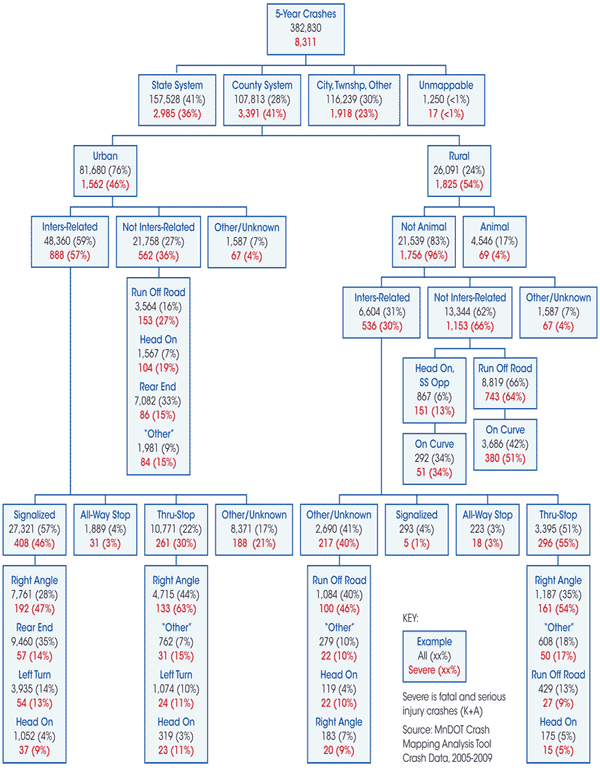
Identify where crash types most frequently occur.
Identify Focus Crash Types and Risk Factors – Task 3: Identify and Evaluate Risk Factors – Risk Factor Identification
Road Features
Traffic Volume
Other Features
| Facility | Potential Risk Factors |
|---|---|
| Rural Segments | ADT, curve density, access density, edge rating |
| Rural Curves | ADT, radius, intersection, visual trap |
| Rural Intersections | ADT, geometry, RR crossing, commercial development, distance from previous stop |
| Urban Signals | Speed, geometry, commercial development |
Data screened by:
Identify roadway characteristics to use as an initial set of potential risk factors to be further evaluated for use in systemic network screening.
Identify Focus Crash Types and Risk Factors – Task 3: Identify and Evaluate Risk Factors – Evaluation of Segment Traffic Volume as a Potential Risk Factor
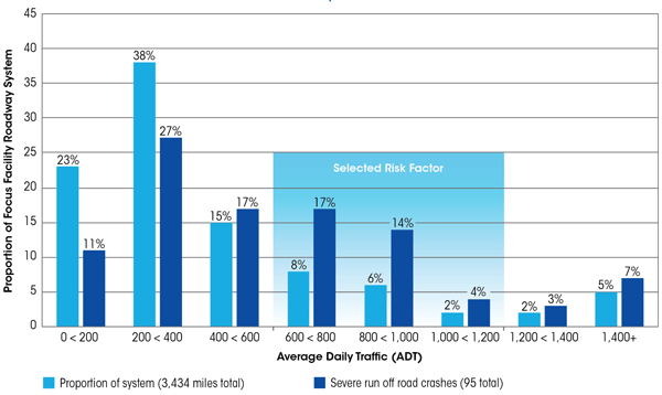
Use descriptive statistics to evaluate Average Daily Traffic (ADT) as a potential risk factor.
600-1,200 ADT was selected as a risk factor because severe crashes were overrepresented on roadways with ADTs in this range.
Identify Focus Crash Types and Risk Factors – Task 3: Identify and Evaluate Risk Factors – Evaluation of Access Density as a Potential Risk Factor
Crash Rate for Minnesota State Highways Based on Access Density
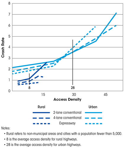
Crash Rate for Rural Minnesota County Roadways Based on Access Density
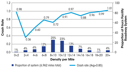
Evaluate access density as a potential risk factor.
Identify Focus Crash Types and Risk Factors – Task 3: Identify and Evaluate Risk Factors – Evaluation of Edge Risk Assessment as a Potential Risk Factor
1 – Good Shoulder, Good Clear Zone
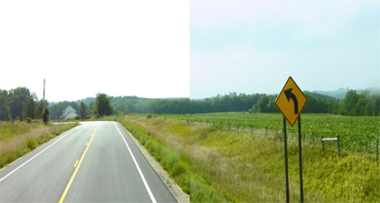
2 – Good Shoulder, No Clear Zone
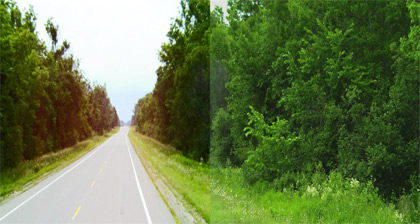
2 – No Shoulder, Good Clear Zone
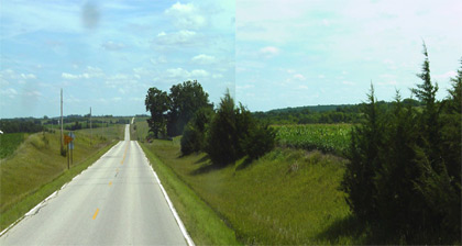
3 – No Shoulder, No Clear Zone
Identify Focus Crash Types and Risk Factors – Task 3: Identify and Evaluate Risk Factors – Evaluation of Edge Risk Assessment as a Potential Risk Factor
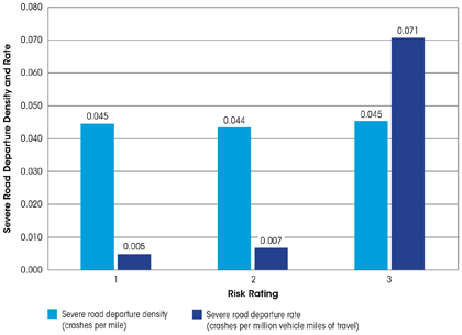
Use descriptive statistics to evaluate edge risk assessment as a potential risk factor.
Screen and Prioritize Candidate Locations – Task 1: Identify Network Elements to Analyze
| Corridor | Route Type | Route Number | Start | End | Length (miles) | Average Daily Traffic |
|---|---|---|---|---|---|---|
| 144.01 | CNTY | 89 | CSAH-30 | CSAH-30 | 1.4 | 480 |
| 40.04 | CSAH | 40 | New London Corp Limit | CSAH-2 | 5.9 | 450 |
| 131.01 | CNTY | 89 | CSAH-30 | MNTH-23 | 0.7 | 145 |
| 9.02 | CSAH | 9 | CR-90, Willmar Corp Limit | CSAH-10 | 5.6 | 940 |
| 5.06 | CSAH | 5 | 150th Ave NW, CSAH-29 | CSAH-1 | 10.1 | 628 |
| 31.02 | CSAH | 31 | New London Corp Limit | MNTH-23 | 1.6 | 920 |
| 8.01 | CSAH | 8 | Renville County Line | Lake Lillian Corp Limit | 3.6 | 750 |
| 4.01 | CSAH | 4 | CSAH-8 | CSAH-20 | 6.7 | 320 |
| 2.05 | CSAH | 2 | CSAH-10 | MNTH-23 | 9.8 | 385 |
| 4.04 | CSAH | 4 | CR-98 | CSAH-40 | 2.4 | 290 |
| 38.01 | CSAH | 38 | CSAH-40 | CSAH-48 | 2.1 | 130 |
| 132.01 | CNTY | 89 | CSAH-8 | CSAH-8 | 2.2 | 190 |
| 42.01 | CSAH | 42 | CSAH-7 | County Line | 0.5 | 120 |
| 9.03 | CSAH | 9 | CSAH-10 | CSAH-40, Redwood Street | 4.9 | 1,800 |
| 25.01 | CSAH | 25 | CSAH-5 | USTH-71 | 3.2 | 1,315 |
| 1.03 | CSAH | 1 | MNTH-23 | Pennock Corp Limit | 7.0 | 333 |
| 116.02 | CNTY | 89 | CSAH-3 | MNTH-40 | 7.0 | 98 |
| 2.04 | CSAH | 2 | Atwater Corp Limit | CSAH-10 | 6.7 | 1,018 |
| 28.02 | CSAH | 28 | CSAH-2 | County Line | 2.0 | 315 |
This table represents 19 of the 77 segments.
Identify the network elements from the focus facility types which represent the locations where the focus crash types tend to occur. The elements are for use in network screening.
Screen and Prioritize Candidate Locations – Task 2: Conduct Risk Assessment
| Rank | Corridor | ADT Range | Road Departure Density |
Access Density | Curve Critical Radius Density |
Edge Risk | Totals |
|---|---|---|---|---|---|---|---|
| 1 | 144.01 | one star | one star | one star | one star | one star | five stars |
| 2 | 40.04 | one star | one star | one star | one star | one star | five stars |
| 3 | 131.01 | – | one star | one star | one star | one star | four stars |
| 4 | 9.02 | one star | one star | one star | one star | – | four stars |
| 5 | 5.06 | one star | one star | one star | one star | – | four stars |
| 6 | 31.02 | one star | one star | one star | one star | – | four stars |
| 7 | 8.01 | one star | one star | – | – | one star | three stars |
| 8 | 4.01 | – | one star | one star | – | one star | three stars |
| 9 | 2.05 | – | – | one star | one star | one star | three stars |
| 10 | 4.04 | – | – | one star | one star | one star | three stars |
| 11 | 38.01 | – | – | one star | one star | one star | three stars |
| 12 | 132.01 | – | – | one star | one star | one star | three stars |
| 13 | 42.01 | – | – | one star | one star | one star | three stars |
| 14 | 9.03 | – | one star | one star | one star | – | three stars |
| 15 | 25.01 | – | one star | one star | one star | – | three stars |
| 74 | 1.03 | – | – | – | – | – | – |
| 75 | 116.02 | – | – | – | – | – | – |
| 76 | 2.04 | – | – | – | – | – | – |
| 77 | 28.02 | – | – | – | – | – | – |
This table represents 19 of the 77 segments.
Evaluate the risk factors of the systems and locations selected for analysis using roadway and traffic characteristics in order to rank/prioritize at-risk locations.
Screen and Prioritize Candidate Locations – Task 2: Conduct Risk Assessment – Determine Feasibility of Selected Risk Factors
Greater Minnesota Segment Risk Factors
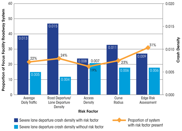
Assess selected risk factors to determine their feasibility for differentiating between elements (curves, segments, and intersections) on the focus facility type.
Screen and Prioritize Candidate Locations – Task 3: Prioritize Focus Facility Elements – Threshold for Selecting Candidate Locations
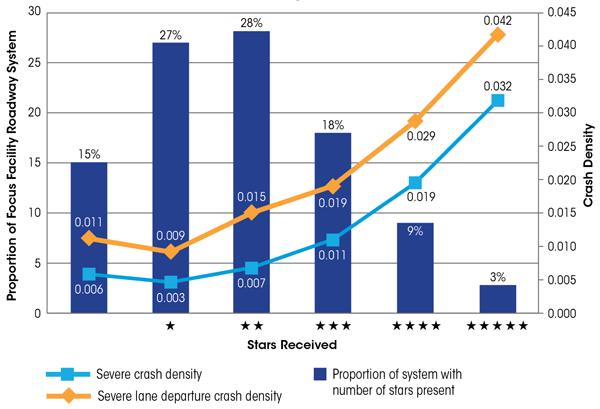
Summarize the locations based on the number of risk factors present to establish a threshold for selecting candidate locations.
The bars indicate the percent of the system that has the number of risk factors present (i.e., stars received). Additionally the chart shows that the severe crash density and severe lane departure crash density increases as more risk factors are present. MnDOT used this chart to determine that those locations with three or more stars present, approximately 30 percent of the focus facility type, would be candidate locations for systemic safety projects.
Select Countermeasures
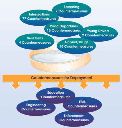
Review NCHRP 500 Reports, Highway Safety Manual, CMF Clearinghouse, FHWA Office of Safety website, and state Strategic Highway Safety Plans to identify a comprehensive list of potential countermeasures for each focus crash type.
Select Countermeasures – Task 1: Assemble Comprehensive List of Countermeasures – List of Potential Countermeasures
| Objectives | Countermeasures | Relative Cost to Implement and Operate | Effectiveness | Typical Timeframe for Implementation |
|---|---|---|---|---|
| 15.1 A: Keep vehicles from encroaching on the roadside | 15.1A1: Install shoulder rumble strips | Low | Tried | Short (<1 year) |
| 15.1 A: Keep vehicles from encroaching on the roadside | 15.1 A2: Install edgelines “profile marking”, edgeline rumble strips or modified shoulder rumble strips on section with narrow or no paved shoulders | Low | Experimental | Short (<1 year) |
| 15.1 A: Keep vehicles from encroaching on the roadside | 15.1 A3: Install midlane rumble strips | Low | Experimental | Short (<1 year) |
| 15.1 A: Keep vehicles from encroaching on the roadside | 15.1 A4: Provide enhanced shoulder or delineation and marking for sharp curves | Low | Tried/Proven/Experimental | Short (<1 year) |
| 15.1 A: Keep vehicles from encroaching on the roadside | 15.1 A5: Provide improved highway geometry for horizontal curves | High | Proven | Long (>2 years) |
| 15.1 A: Keep vehicles from encroaching on the roadside | 15.1 A6: Provide enhanced pavement markings | Low | Tried | Short (<1 year) |
| 15.1 A: Keep vehicles from encroaching on the roadside | 15.1 A7: Provide skid-resistance pavement surfaces | Moderate | Proven | Medium (1-2 years) |
| 15.1 A: Keep vehicles from encroaching on the roadside | 15.1 A8: Apply shoulder treatments
|
Low | Experimental Experimental Proven |
Medium (1-2 years) |
| 15.1 B: Minimize the likelihood of crashing into an object or overturning if the vehicle travels off the shoulder | 15.1 B1: Design safer slopes and ditches to prevent rollovers | Moderate | Proven | Medium (1-2 years) |
| 15.1 B: Minimize the likelihood of crashing into an object or overturning if the vehicle travels off the shoulder | 15.1 B2: Remove/relocate objects in hazardous locations | Moderate to High | Proven | Medium (1-2 years) |
| 15.1 B: Minimize the likelihood of crashing into an object or overturning if the vehicle travels off the shoulder | 15.1 B3: Delineate trees or utility poles with retroreflective tape | Low | Experimental | Short (<1 year) |
| 15.1 C: Reduce the severity of the crash | 15.1 C1: Improve design of roadside hardware | Moderate to High | Tried | Medium (1-2 years) |
| 15.1 C: Reduce the severity of the crash | 15.1 C2: Improve design and application of barrier and attenuation systems | Moderate to High | Tried | Medium (1-2 years) |
Source: NCHRP 500 Volume 6 (2003)
Assemble an initial comprehensive list of countermeasures associated with focus crash type.
Initial list of countermeasures MnDOT identified to reduce road departure crashes using the NCHRP 500 Volume 6 report.
Select Countermeasures – Task 2: Evaluate/Screen Countermeasures – Countermeasure Effectiveness
Proven
Tried
Experimental
Source: NCHRP 500 Reports
Evaluate and screen the initial list of countermeasures based on documented effectiveness of reducing the focus crash types and consistency with the agency's policies, practices, and experiences.
MnDOT used the NCHRP 500 reports to determine an initial estimate of effectiveness with their classification of each countermeasure as Proven (effective), Tried, or Experimental to narrow down the initial list of countermeasures.
Select Countermeasures – Task 3: Select Countermeasures for Deployment – Countermeasures Selected for Deployment
| Objectives | Countermeasures | Relative Cost to Implement and Operate | Effectiveness | Typical Timeframe for Implementation |
|---|---|---|---|---|
| 15.1 A: Keep vehicles from encroaching on the roadside | 15.1 A1: Install shoulder rumble strips | Low (<$10,000/mile) | Proven (information updated by CH2M HILL) | Short (<1 year) |
| 15.1 A: Keep vehicles from encroaching on the roadside | 15.1 A2: Install enhanced pavement markings, edgeline rumble strips or modified shoulder rumble strips on section with narrow or no paved shoulders | Low (<$10,000/mile) | Experimental/Tried | Short (<1 year) |
| 15.1 A: Keep vehicles from encroaching on the roadside | 15.1 A3: Install centerline rumble strips | Low (<$10,000/mile) | Proven (information updated by CH2M HILL) | Short (<1 year) |
| 15.1 A: Keep vehicles from encroaching on the roadside | 15.1 A4: Provide enhanced shoulder or delineation and marking for sharp curves | Low (<$10,000/mile) | Tried/Proven | Short (<1 year) |
| 15.1 A: Keep vehicles from encroaching on the roadside | 15.1 A5: Provide improved highway geometry for horizontal curves | High | Proven | Long (>2 years) |
| 15.1 A: Keep vehicles from encroaching on the roadside | 15.1 A8: Apply shoulder treatments
|
Moderate (information updated by CH2M HILL) | Experimental Experimental Proven |
– |
| 15.1 B: Minimize the likelihood of crashing into an object or overturning if the vehicle travels off the shoulder | 15.1 B1: Design safer slopes and ditches to prevent rollovers | Moderate to High (information updated by CH2M HILL) | Proven | Medium (1-2 years) |
| 15.1 B: Minimize the likelihood of crashing into an object or overturning if the vehicle travels off the shoulder | 15.1 B2: Remove/relocate objects in hazardous locations | Moderate to High (information updated by CH2M HILL) | Proven | Medium (1-2 years) |
Source: NCHRP 500 Volume 6 (2003)
Identify and select a few countermeasures for each focus crash type based on the evaluation of the countermeasures and consideration of agency priorities, practices, and policies.
MnDOT paired down the list of countermeasures identified in Task 1 to address road departure crashes based on the evaluation. These countermeasures were selected to develop safety projects.
Prioritize Projects – Task 1: Create a Decision Process for Countermeasure Selection – Decision Tree
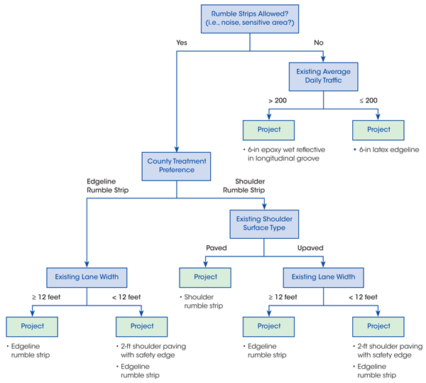
Develop a decision process to facilitate consistency in the selection of countermeasures.
Provides county engineer with opportunity to identify treatment preferences while selecting projects that MnDOT is comfortable funding.
Prioritize Projects – Task 2: Develop Safety Projects – Safety Projects Selected for Development
County Highway 26 from State Highway 23 to County Highway 15
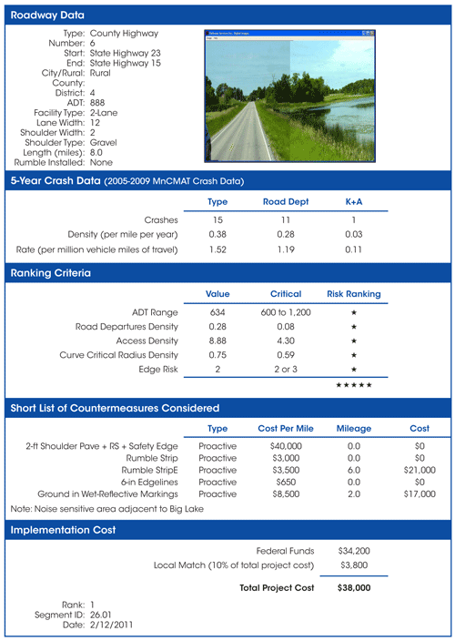
| Region | 2-ft Shoulder Pave, Rumble Strips, and Safety Edge (miles) | Shoulder Rumble Strips (miles) | Edgeline Rumble Strips (miles) | 6-inch Edgelines (miles) | Ground in Wet-Reflective Markings (miles) | Total Project Value |
|---|---|---|---|---|---|---|
| 1 | 180 | 373 | 673 | 50 | 636 | $16,106,107 |
| 2 | 151 | 147 | 560 | 210 | 180 | $10,095,868 |
| 3 | 153 | 91 | 332 | 46 | 306 | $10,196,428 |
| 4 | 106 | 139 | 758 | 200 | 85 | $8,158,210 |
| Total | 591 | 749 | 2,323 | 505 | 1,207 | $44,556,613 |
Apply decision process to develop specific safety projects for each candidate site selected for safety investment.
Prioritize Projects – Task 3: Prioritize Safety Project Implementation – Project Prioritization Process
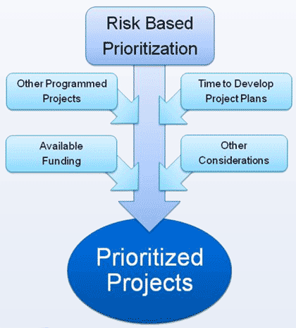
Identify the order in which projects will be implemented.
Prioritizing the projects for implementation will start with the number of risk factors present at a given location. Several other factors may play a role in the selection process, such as funding availability, other programmed projects, time to develop project plans amount of public outreach needed, etc. For example, a lower priority project may be selected over a higher priority project if the location is in an established capital improvement program.
Element 1 of the Systemic Safety Project Selection Tool presents a general process for conducting systemic safety planning efforts, which is intended to complement an agency's site-specific analysis process—not replace it.
This systemic safety planning process involves four steps:
The systemic safety planning process is a data-driven process that identifies the types of crashes which represent the greatest opportunity for substantially reducing the number of severe crashes, the locations that have the greatest potential for severe crashes but do not have a high crash history, and a short list of highly effective countermeasures. The systemic safety planning process is flexible. Any agency can adapt the tool to fit their needs, and this flexibility allows agencies to develop a process that leads to implementation within the constraints of their data availability, program requirements, staff capabilities, and funding. While there can be variation in the detail and time invested or specific actions conducted for each task, the ultimate goal is to direct low-cost, effective countermeasures where the greatest opportunities exist to prevent severe crashes and improve safety.
| << Previous | Table of Content | Next >> |

