U.S. Department of Transportation
Federal Highway Administration
1200 New Jersey Avenue, SE
Washington, DC 20590
202-366-4000
Downloadable version: PDF [729 KB]
In This Issue
Safety Compass Newsletter
A publication of the Department of Transportation, Federal Highway Administration The Safety Compass newsletter is published for internet distribution quarterly by the:
FHWA Office of Safety
1200 New Jersey Avenue SE, Room E71
Washington, DC 20590
The Safety Compass can also be viewed at: http://safety.fhwa.dot.gov
Editor-in Chief
Janet Ewing
janet.ewing@dot.gov
Associate Editors
Lincoln Cobb
lincoln.cobb@dot.gov
Judith Johnson
judith.johnson@dot.gov
Your comments and highway safety related articles are welcomed. This newsletter is intended to be a source to increase highway safety awareness, information and provide resources to help save lives. You are encouraged to submit highway safety articles that might be of value to the highway safety community. Send your comments, questions and articles for review (electronically) to: janet.ewing@dot.gov.
Please review guidelines for article submittals at: http://safety.fhwa.dot.gov/newsletter/
safetycompass/guidelines.cfm
If you would like to be included on the distribution list to receive your free issues, please send your email address to: janet.ewing@dot.gov.
![]()
U.S. Secretary of Transportation Mary Peters Announces New Data Showing Record Low Highway Fatalities
The number of people killed in traffic crashes is expected to reach a new record low in 2008, with early projections showing an almost 10 percent drop in highway traffic deaths in the first 10 months of this year. In 2007, there were 41,059 traffic fatalities. For more information, visit http://www.dot.gov/affairs/dot17508.htm
Keeping citizens safe on the highways is a top priority for the Washington State Department of Transportation (WSDOT). Over the past decade, there has been a downward trend in traffic fatalities on Washington State’s highways, streets, county roads, and other public roadways. This trend continued in 2007 with a 10.6% decrease from 2006. These reductions are due in part to new State laws, including the seat belt law, tougher impaired driving laws, increased enforcement (including speed and DUI patrols), and significant investments in highway safety projects. These projects include cable median barriers, rumble strips, and intersection modifications.
In 2006, there were 65 fatal collisions on State highways where “over centerline” was identified as a contributing circumstance. To reduce these collisions, WSDOT has installed, or will install, centerline rumble strips on roughly 960 miles of Washington highways.
Rumble strips are grooves or rows of raised pavement markers placed perpendicular to the direction of travel to alert inattentive drivers. As a vehicle passes over the rumble strips, they produce noise and vibration, alerting the driver that they are drifting from their lane. Of the highway miles with centerline rumble strips, WSDOT engineers have conducted preliminary evaluations of 518 miles that have been in place six months or longer.
Preliminary results indicate:
28% reduction in all fatal and serious injury collisions
26% reduction in all crosscenterline collisions
50% reduction in fatal and serious injuries resulting from crosscenterline collisions.
It is important to note that these reductions may not be entirely attributable to rumble strips, as other safety improvements may have been implemented under the same contract that installed the rumble strips.
Previous analyses of rumble strips have focused on cross-centerline collisions. As a next step, WSDOT will analyze all collision types - not just over-centerline - before and after the installation of centerline rumble strips. Although reducing overcenterline collisions is the expected benefit from centerline rumble strips, there may be other collision types affected by rumble strips. This study will evaluate centerline rumble strips, shoulder rumble strips and the combination of centerline and shoulder rumble strips. It will also identify the contributing factors and site conditions where rumble strips are the most and least effective. The study is expected to be available in six to nine months. The study’s outcomes will guide future locations that would benefit from rumble strip installation.
Cable median barriers are installed to reduce the risk of vehicles leaving the roadway and striking hard objects, steep slopes, or crossing into oncoming traffic. While it is not possible to prevent all crossover collisions or vehicles leaving the road, cable barriers on the roadside or in the median help reduce the risk of very severe collisions.
WSDOT installed 43 miles of cable median barrier in 2007, bringing the statewide total to 177 miles. WSDOT engineers analyzed the performance of the State’s cable median barriers from 1995 through 2007 by reviewing nearly 2,550 collisions in the median. They found:
A 62% reduction of serious injury and fatal collisions (24.8/year to 9.5/year after installation).
Annual cross median collisions decreased 73%.
These reductions are significant: traffic volume grew 13% for the 177 miles of highway where WSDOT installed cable median barriers during this same time.
Collisions in the median routinely increase after any type of median barrier system is installed. An errant vehicle that may have been able to travel 30 or 40 feet into an open median before installation may only be able to travel 15 to 20 feet before it strikes a newly placed barrier. This creates a dilemma for WSDOT engineers in determining how to balance the benefits and risks of barriers.
Median barriers reduce the risk of serious crossover collisions but also create some risks for drivers who run off the road, as the barriers are more likely to be struck, since cable barriers tend to capture vehicles.
Cable barriers offer two advantages over concrete or beam guardrail barriers: vehicles have a lower likelihood of rebounding back into traffic, and injuries are usually less severe. Concrete barriers reduce cross-median collisions more effectively than cable, but result in more frequent injuries. Cable barriers are also effective in reducing rollover collisions in the median. Although cable barriers may not contain a vehicle that is already rolling, those highways with barriers experienced a 37% reduction in annual median rollover collisions. These collisions often result in severe injuries, as occupants are subject to a wider range of forces and impacts with their vehicle’s components.
Note: This article is extracted from the Gray Notebook, WSDOT’s quarterly performance report on transportation systems, programs and department management. WSDOT provides an annual update on highway safety. This article, and other articles on highway safety, can be found at http://www.wsdot.wa.gov/Accountability/.
For additional information contact:
Daniela Bremmer, Director of Strategic Assessment
(360) 705-7953 bremmed@wsdot.wa.gov
Ted Trepanier, State Traffic Engineer
(360) 705-7280 trepant@wsdot.wa.gov
Dave Olson, Design Policy, Standards and Research Engineer
(360) 705-7952 olsonda@wsdot.wa.gov
By Pete K. Rahn, Director, Missouri Department of Transportation
Of the more than 41,000 people killed on our Nation’s highways annually, over 25,000 - nearly 60 percent - of fatalities occur when vehicles unsafely depart a lane and/or roadway, with most of these single vehicle crashes. In some cases, the vehicle crossed the centerline and was involved in a head-on crash or opposite direction sideswipe. In others, the vehicle left the roadway to roll over or impact one or more natural or man-made objects, such as trees, utility poles, bridge walls, embankments, or guardrails.
 As part of American Association of State Highway and Transportation Officials’ (AASHTO) goal to aggressively reduce highway fatalities, their recent report “Driving Down Lane-Departure Crashes: A National Priority” emphasizes roadway departure solutions and supports FHWA’s Roadway Departure program. Pete Rahn writes in the preface to the report, “As you turn the pages of Driving Down Lane-Departure Crashes – a National Priority, think of this: By the time you have finished reading this report; one more person will have died as a result of a run-off-the road crash. Every 21 minutes a highway death occurs from lane departure. All of us within a State Department of Transportation have a responsibility for improving the safety of people on our roads, but some States have emerged, through top level leadership, as true champions. As shown throughout this report, they have implemented systematic, low-cost improvements that have resulted in dramatic reductions in crashes and fatalities.
While this report highlights a number of remedies for keeping drivers on the road, the essential ingredient in improving our safety record is your commitment as the leader of a State department of transportation.”
Often transportation officials act to improve a high-incident location, when there may be another identical situation elsewhere on the system. The AASHTO report stresses that a key to reducing crashes is use of a systematic approach and recommends eight specific ways to make positive safety improvements. The improvements described in this report are most effective when they are applied throughout the highway system, as a means to keep future crashes from occurring. The report also includes examples of successfully State- implemented strategies that can be used to keep vehicles safely on the road, or protected if they leave the roadway, and which have resulted in significant reductions in crashes and fatalities.
Missouri DOT has focused on lane departure countermeasures over the past three years, resulting in a 25 percent reduction in lane departurerelated fatalities from 2005 to 2007. System-wide safety solutions that they incorporated include:
For a copy of this report, visit the AASHTO Web site at http://www.transportation.org
Low-Cost Treatments for Horizontal Curve Safety (guide): About 1 of 4 fatalities occurs at or near a horizontal curve. This practical reference on how to keep vehicles on the roadway is online at http://safety.fhwa.dot.gov/roadway_dept/horicurves/fhwasa07002/fhwasa07002.pdf. (Publication # FHWA-SA-07-002)
The Safety Edge (revised brochure): This incorporates current research on the tapered wedge treatment that mitigates pavement edge dropoffs, which can reduce crashes and decrease tort liability. Online at http://safety.fhwa.dot.gov/roadway_dept/docs/sa07023/sa07023.pdf. (Publication # FHWA-SA-07-023)
Rumble Strips: A Sound Investment (DVD): An introduction to the effectiveness and design of shoulder, edge and centerline rumble strips/stripes, all cost-effective treatments proven to reduce crashes caused by distracted or inattentive drivers. (Publication # FHWA-SA-07-024)
Highway Safety and Trees: The Delicate Balance (DVD and brochure): Addresses the hazards of trees adjacent to roadways and design solutions that objectively consider safety with other community concerns. (DVD # FHWA-SA-06-13. Brochure # FHWA-SA-06-12.) Brochure online at http://safety.fhwa.dot.gov/roadway_dept/clear_zones/fhwasa0612/.
For more information about the FHWA Roadway Departure Program, contact Mary McDonough, FHWA Office of Safety Roadway Departure Team Leader at (202) 366-2175 or mary.mcdonough@dot.gov.
 NATIONAL ROADWAY SAFETY AWARD WINNER
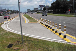 Qwick Kurb®
The Florida Department of Transportation’s District 7 Traffic Operations Safety Office developed a rapid deployment safety program utilizing the Qwick Kurb® median separator system. The system’s ease of installation allows for fast deployment at high crash locations where it is determined immediate action will greatly reduce accidents in places such as work zones, problematic intersections and merge areas.
Florida has used Qwick Kurb® to quickly redirect traffic or close full median openings in lieu of conventional roadway construction solutions that are more costly and time-consuming. From March to September 2007, the system was implemented at 16 full median opening project locations. Its cost effectiveness and construction time savings have been remarkable. For an estimated cost of $15,000 per location, it has been calculated that the installation has resulted in eight crash reductions per year per location, with an associated net construction cost savings of approximately $125,000 per location. Using this system has reduced the construction time to address safety issues from a typical 30-month process to just two weeks!
For more information, contact: Peter Hsu, P.E., Florida Department of Transportation, Telephone: (813) 975-6251, Email: ping.hsu@dot.state.fl.us
The National Roadway Safety Awards Program honors agencies and organizations in the transportation community that have made verifi able and significant strides toward improving the safety of our Nation’s highways through infrastructure improvements, operational improvements or program planning, development and evaluation. Co-sponsored by the Federal Highway Administration and the Roadway Safety Foundation, this biennial program examines the “best of the best” using effectiveness, innovation, and effi cient use of resources as criteria in determining which projects will receive this coveted award. Previous issues of the Safety Compass have spotlighted many of the 2007 Safety Award winners. This issue describes four more award-winning programs from Florida, California, Illinois and Wisconsin. The 2009 program year will begin with a call for nominations in January 2009. Please check the program website for more information: http://www.roadwaysafetyawards.org/
 NATIONAL ROADWAY SAFETY AWARD - HONORABLE MENTION
Safety and Farm Labor Vehicle Education (SAFE) Program
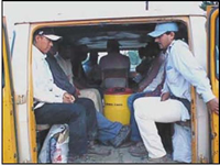 The Safety and Farm Labor Vehicle Education (SAFE) Program was created in 1999 to address the transportation of thousands of farm workers who are hired for field labor within the boundaries of the California Highway Patrol’s (CHP) Central Division. Prior to the implementation of this program, an alarming number of accidents occurred in which innocent farm workers lost their lives due to the poor conditions of the vehicles in which they were transported. The objectives of the SAFE program are to provide education and enforcement in an effort to reduce farm labor vehicle (FLV) collisions and fatalities due to unsafe vehicles. Since the inception of the program, the CHP has established a positive working relationship with farm workers, labor contractors, and the farming community. SAFE has successfully utilized bilingual officers to reach out to a community which traditionally has been reluctant to interact with law enforcement. Other resources used to accomplish this objective include a toll-free number to report violators and electronic and print media. In addition, SAFE officers appear regularly on both English and Spanish television and radio programs to inform audiences of FLV inspection operations and offer important traffic safety tips for FLV’s and farm worker transportation.
The success has led to the expansion of the SAFE program to other CHP Field Divisions. The program has also gained nationwide notoriety by prompting new Federal regulations introduced in 2006 that relate to the safety of field workers.
For more information, contact: Jose Gutierrez, California Highway Patrol, Telephone: (559) 445-6100, Email: jogutierrez@chp.ca.gov
NATIONAL ROADWAY SAFETY AWARD – HONORABLE MENTIONTazewell County Teen Initiative
Between March 2005 and July 2006, 15 teenagers died in traffic crashes on Tazewell County, Illinois roadways. This was a marked and disturbing increase over what is typically an average of one to two fatalities annually.
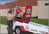 The Illinois State Police District 8, along with the Illinois Department of Transportation (IDOT), the Tazewell County Sheriff, and the Tazewell County Coroner convened numerous local and State authorities and stakeholders to discuss this situation and determine how to make immediate and longterm improvements to address this problem. The outcome of the combined effort was the Tazewell County Teen Initiative, a creative and ambitious initiative that sparked a multifaceted public awareness campaign targeted at schools, hospitals, emergency response teams, media and the private sector.
The initiative included special enforcement campaigns staffed by officers from every police agency in Tazewell County; educational programs developed by students, teachers and school administrators; $1.2 million in road upgrades facilitated by IDOT and the Tazewell County Traffic Engineering Department; and educational programs and equipment donated by corporations such as Ford Motor Company Foundation, Caterpillar Tractor Company, and State Farm Insurance. Since the program’s launch, there have been no teenage traffic fatalities in Tazewell County. This is truly a safety success.
For more information, contact: Capt.Dean Kennedy, Illinois State Police, Telephone: (309) 383-2171, Email: kennedd@isp.state.il.us
NATIONAL ROADWAY SAFETY AWARD – HONORABLE MENTIONRoad Weather Safety Audits
 The Road Safety Audit (RSA) is a frequently-used method whereby independent qualified teams examine the safety performance and crash potential of existing and planned roads and traffic projects. The Road Weather Safety Audit (RWSA) is a logical extension of conventional RSAs, with particular emphasis on highway safety from an adverse weather impact perspective.
Most RSAs are performed under favorable weather conditions. Consequently, the impact of traffic operations and safety during adverse weather conditions such as snow, rain, sleet, and fog are often not considered. A study by the University of Wisconsin-Madison resulted in the institutionalization of the RWSA into WisDOT’s policy, heightening awareness of weather issues that impact infrastructure and operations.
The project had several objectives, including development of a comprehensive and formalized RWSA for Wisconsin; defining and identifying key processes and procedures for RSAs and RWSAs under WisDOT’s organizational structure; providing a framework to implement audit procedures through checklists covering all stages of a road project; integrating the RSA/RWSA with current policies by incorporating it into the WisDOT Facilities Development Manual; and identifying and providing sources and procedures for basic information regarding the preparation of data for different stages of the audit process.
For more information, contact: Todd Szymkowski, University of Wisconsin-Madison Traffic Operations and Safety Laboratory, Telephone: (608) 263-2684, Email: szymkowski@engr.wisc.edu
For nearly a decade, this biennial program has recognized the best and brightest in safety programs including Infrastructure, Operations and Program Planning Development and Evaluation. Prior winners have received nationwide media attention, additional hometown recognition, a general increase in safety program awareness and, in some cases, funding opportunities for their award-winning programs, so there is no shortage of reasons to apply!
For more information, visit http://www.roadwaysafetyawards.orgAs indicated in an action memo to FHWA field offices on the implementation of proven safety countermeasures, the Office of Safety strongly encourages widespread use of the following countermeasures to accelerate achieving local, State, and national safety goals.
Road Safety Audits. A road safety audit (RSA) is a formal safety performance examination of an existing or future road or intersection by an independent and multi-disciplinary team. It reports on potential road safety issues and identifies opportunities for improvements in safety for all road users.
Rumble Strips and Rumble Stripes. Rumble strips are raised or grooved patterns on the roadway that provide both an audible warning (rumbling sound) and a physical vibration to alert drivers that they are leaving the driving lane. They may be installed on the roadway shoulder or on the enterline of undivided highways. If the placement of rumble strips coincides with centerline or edgeline striping, the devices are referred to as rumble stripes.
Median Barriers. Median barriers are longitudinal barriers used to separate opposing traffic on a divided highway. They are designed to redirect vehicles striking either side of the barrier. Median barriers can significantly reduce the occurrence of cross-median crashes and the overall severity of median-related crashes.
Safety Edge. The Safety Edge is a specific asphalt paving technique where the interface between the roadway and graded shoulder is paved at an optimal angle to minimize vertical drop-off and provide a safer roadway edge. A Safety Edge shape can be readily attained by fitting resurfacing equipment with a device that extrudes and compacts the shape of the pavement edge as the paver passes. This mitigates shoulder pavement edge drop-offs immediately during the construction process and over the life of the pavement. This technique is not an extra procedure but merely a slight change in the paving equipment that has a minimal impact on the project cost. In addition, the Safety Edge improves the compaction of the pavement near the edge. Shoulders should still be pulled up flush with the pavement.
Roundabouts. The modern roundabout is a type of circular intersection defi ned by the basic operational principle of entering traffic yielding to vehicles on the circulatory roadway and certain key design principles to achieve deflection of entering traffic by channelization at the entrance and deflection around a center island. Modern roundabouts have geometric features providing a reduced speed environment that offers substantial safety advantages and excellent operational performance.
Left and Right Turn Lanes at Stop-Controlled Intersections. Left-turn lanes are auxiliary lanes for storage or speed change of left-turning vehicles. Installation of left-turn lanes reduces crash potential and motorist inconvenience, and improves operational efficiency. Right-turn lanes provide a separation between rightturning traffic and adjacent through traffic at intersection approaches, reducing conflicts and improving intersection safety.
Yellow Change Intervals. The yellow change interval is the interval following a green signal indication during which the yellow signal indication is displayed to warn drivers of the impending change in right-of-way assignment. Yellow change intervals that are not consistent with normal operating speeds create a dilemma zone in which drivers can neither stop safely nor reach the intersection before the signal turns red.
Medians and Pedestrian Refuge Areas in Urban and Suburban Areas. The Median is the area between opposing lanes of traffic, excluding turn lanes. Medians can either be open (pavement markings only) or they can be channelized (raised medians or islands) to separate various road users. Pedestrian Refuge Areas (or crossing islands)—also known as center islands, refuge islands, pedestrian islands, or median slow points—are raised islands placed in the street at intersection or midblock locations to separate crossing pedestrians from motor vehicles.
Walkways. Several types of pedestrian walkways have been defined:
Pedestrian Walkway (Walkway): A continuous way designated for pedestrians and separated from motor vehicle traffic by a space or barrier.
Shared Use Path: A bikeway or pedestrian walkway physically separated from motorized vehicular traffic by an open space or barrier - either within a highway right-of-way or within an independent right-of-way. Shared use paths may also be used by pedestrians, skaters, wheelchair users, joggers, and other nonmotorized users. Shared use paths also may be referred to as “trails” or “multiple-use trails.”
Sidewalks: Walkways that are paved and separated from the street, generally by curb and gutter.
Roadway Shoulder: In rural or suburban areas where sidewalks and pathways are not feasible, gravel or paved highway shoulders provide an area for pedestrians to walk next to the roadway.
For more information on these countermeasures, visit http://safety.fhwa.dot.gov.
Washington, D.C. – American motorists blame other motorists for unsafe driving, despite the fact that many admit to doing the same dangerous practices themselves, according to a new report by the AAA Foundation for Traffic Safety. For example, Americans rated drinking drivers as the most serious traffic safety issue, yet in the previous month alone, almost 10 percent of motorists admitted to driving when they thought their blood alcohol content was above the legal limit.
“Where’s the outrage? Every 13 minutes, someone dies on America’s roads – yet the Nation seems complacent about these preventable tragedies,” said AAA Foundation for Traffic Safety CEO Peter Kissinger. “The 2008 Traffic Safety Culture Index makes clear that while motorists are quick to blame the ‘other guy’ for deadly practices like drunk, aggressive or distracted driving, too often those pointing the finger are themselves part of the problem.”
Traffic crashes are the leading killer of people aged 2 to 34, with the overall death toll on U.S. roadways consistently exceeding 40,000 every year since the early 1960s, with the sole exception of 1992. With this in mind, the AAA Foundation for Traffic Safety launched its first annual survey of the driving public on a wide variety of issues. Highlights from the 2008 Traffic Safety Culture Index include:
Three out of four of motorists believed that they are more careful than others behind the wheel.
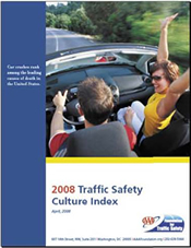 Eighty-two percent of motorists rated distracted driving as a serious problem, yet over half of those same individuals admitted to talking on the cell phone while driving in the past month, and 14 percent even admitted to reading or sending text messages while driving.
Over seven out of ten motorists rated red light running as a serious problem, yet over half of those same individuals admitted to speeding up to get through yellow lights, and five percent even admitted to having run a red light on purpose in the past month.
Nearly three out of every four motorists rated speeding as a serious problem, yet 40 percent of those same individuals admitted to driving 15 mph or more over speed limit on the highway in the past month, and 14 percent even admitted to having driven 15 mph or more over the limit on a neighborhood street.
“All of us should work to build a better traffic safety culture, where more than 40,000 deaths annually is NOT considered acceptable, where in conjunction with tougher laws, safer cars and better engineering, individuals take responsibility for their own driving instead of blaming the other guy,” said Kissinger.
The full report “2008 Traffic Safety Culture Index” is available online at http://www.aaafoundation.org.
For more information contact Fairley Mahlum, AAA Foundation for Traffic Safety, at (202) 638-5944 ext 4, or fmahlum@aaafoundation.org.
Americans rated drinking drivers as the most serious traffic safety issue, yet in the previous month alone, almost 10 percent of motorists admitted to driving when they thought their blood alcohol content was above the legal limit.
Making the Case for Transportation Safety – Ideas for Decision Makers features 20 examples of noteworthy practices successfully implemented by executives, managers, stakeholders, and practitioners working to improve safety on the Nation’s roadways.
Each noteworthy practice includes:
The book also includes a section on the importance of integrating safety into the transportation planning process and resources that provide data and support for safety practitioners.
To access Making the Case for Transportation Safety – Ideas for Decision Makers, visit: http://tsp.trb.org/research.asp.
For additional information, please contact: Tamiko Burnell, Transportation Specialist, FHWA Office of Safety at (202) 366-1200 or tamiko.burnell@dot.govCrash Reduction Initiative on Secondary and Rural Roads
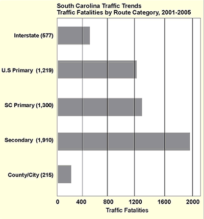
In 2002, South Carolina had the third highest death rate by vehicle miles traveled (VMT) in the Nation, with 2.23 deaths per 100 million VMT, a rate 48 percent higher than the national average of 1.5. Most of the safety problems were occurring on rural secondary roads, which had a fatality rate over three times higher than Interstate highways (3.42 versus 0.92). The South Carolina Department of Transportation (SCDOT) is responsible for over 65 percent of the State’s roadway system, including the majority of secondary roads. Most of the secondary roads are not eligible for Federal-aid funding, and SCDOT previously had dedicated few resources to address problems on those roads.
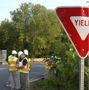
In 2003, SCDOT initiated the Crash Reduction by Improving Safety on Secondaries (CRISOS) program, which used crash and fatality rates to identify high-risk rural secondary roads. These roadways were also screened for crash patterns that could be mitigated with engineering solutions. Once a list of CRISOS roadways was developed, SCDOT coordinated an initial site visit to determine whether low-cost strategies would be applicable. For eligible locations, a multidisciplinary Road Safety Audit (RSA) team conducted a full field review and made project recommendations.
SCDOT allocated $16 million per year over five years for low cost improvements on CRISOS roads. Funding for the CRISOS program was initially made possible due to an innovative TEO-45 indirect cost soft match program approved by FHWA. This allowed the SCDOT to recover eligible administrative costs that would not otherwise be claimed on Federal-aid projects. This savings provided the fl exibility for the SCDOT to advance the CRISOS program as a State funded activity. Some improvements implemented on CRISOS roads since 2004 include extra large stop signs, guardrail installation, vegetation removal, rumble strips, retroreflective sheeting on sign channel posts, and chevron signs on curves.
To complement the infrastructure improvements, SCDOT worked with emergency medical services (EMS), public information and education specialists to incorporate information on roadway departure crashes and safe driving strategies into their ongoing outreach activities. SCDOT worked with local and State law enforcement agencies to conduct targeted enforcement on CRISOS roads, and officers added information on rural secondary road safety to their public outreach efforts. SCDOT’s Safety and Communications Offices also secured significant print and electronic media coverage of the issue.
| Saving Lives A Vital Goal |
VISION |
GOAL |
FOCUS |
PRIORITIES |
Results
Fatalities on CRISOS roads declined from an average of 71 deaths per year between 1998 and 2002 to an average of 62 deaths from 2006 to 2007, a 13-percent reduction. An average of 1,752 injuries occurred on CRISOS roads from 2006 to 2007, which is a reduction of 116 (6 percent) compared to the annual average of 1,868 injuries between 1998 and 2002.
Due to the success of the CRISOS program, it has been expanded to all high crash rural roads regardless of classification, and is now funded through traditional methods of indirect cost recovery
Key Accomplishments
Developed CRISOS, a targeted hazardous location program that decreased traffic related fatalities and serious injuries.
Used RSAs to identify problems and potential solutions. (SCDOT has completed nearly 150 RSAs on CRISOS roads since 2004)
Expanded the CRISOS program to all rural roads and included low cost, short-term safety improvements in the State’s Strategic Highway Safety Plan.
Implemented a multidisciplinary approach to traffic safety, including engineering improvements, increased enforcement and education, and support from the emergency medical services community.
Contacts and Resources
Terecia Wilson
Director, Strategic Highway Safety Plan
SCDOT
(803) 737-0403
wilsontw@scdot.org
As Federal and State funds for building roads decrease and a greater proportion of funding is used for maintenance activities, State DOTs must develop creative, cost-effective solutions to extend the useful life and performance of critical facilities. Faced with the reality that jurisdictions cannot simply build their way out of congestion problems, plus the growing need for focused countermeasures to reduce fatalities and injuries, Virginia planners and safety engineers have jointly developed a plan to address such problems. The Strategically Targeted Affordable Roadways Solutions (STARS) program involves State and local transportation planners, traffic engineers, safety engineers and operations staff in identifying “hot spots” along Virginia roadways where safety and congestion problems overlap, and where shortterm operational improvements are feasible.
 At the core of this new program is an innovative, GIS-based methodology that analyzes and assists with the identification and prioritization of the critical safety and congestion locations in each of Virginia’s five Systems Operations Regions. Each region has established a multi-disciplinary team to oversee program implementation. Each team’s focus is to identify and prioritize specific highway locations and then determine feasible lowcost, high-benefit improvements that target safety and congestion problems.
The types of countermeasures considered include:
Final recommendations from STARS will be incorporated into Virginia’s 2035 State Highway Plan, which will be finalized late 2009.
Funding to implement STARS project recommendations may come from the Highway Safety Improvement Program, designated funds, and/or coordinated with planned maintenance improvements.
The STARS program is truly a collaborative effort within VDOT, the MPOs, the Governor’s Highway Safety Office, and local government safety officials. A presentation on STARS was made at the 2008 Traffic Records Forum in July.
For more information, please contact Robin Grier, Assistant Division Administrator for Transportation and Mobility Planning for VDOT, at robin.grier@vdot.virginia.gov.
By Ed Rice, FHWA Office of Safety, Intersection Team Leader
What exactly is a roundabout, and how are today’s roundabouts different from the traditional traffic rotaries that have been in use for decades? A modern roundabout is a type of circular intersection, engineered for safety by incorporating islands on the approaches, yield control of entering traffic, and appropriate roadway curvature to reduce vehicle speeds. Today’s roundabouts are typically smaller than the large, high-speed rotaries still in use in some parts of the country, yet they are larger than neighborhood traffic circles used to calm traffic.
Compared to other types of intersections, roundabouts have demonstrated safety and operational benefits by reducing crashes, congestion, pollution and costs. They also benefit the immediate community with their functional and often aesthetically pleasing designs, as well as the resultant noise reduction.
 The Office of Safety has released a brochure entitled Roundabouts: A Safer Choice to “demystify” roundabouts for those who are still not convinced of their benefits. The publication’s target audience is the public, decision makers, legislators and others interested in learning about or promoting roundabouts.
The brochure highlights the following key benefits of modern roundabouts:
Improved safety
Reduced congestion
Reduced pollution and fuel use
Money savings
Complement common community values
Education is vital to the acceptance and success of roundabouts. Navigating a roundabout is simple, yet drivers can be apprehensive about new and unfamiliar traffic scenarios. The brochure discusses key points to consider when driving through roundabouts.
Over 17,000 copies of the brochure have been requested and distributed to date. For more information, or to request copies, please contact Ed Rice, FHWA Intersection Team Leader, at (202) 366-9064, or ed.rice@dot.gov.
2008 Release - Interactive Highway Safety Design Model (IHSDM)The Federal Highway Administration, Office of Safety Research & Development has issued its 2008 Public Release (Version 5.0.0) of the Interactive Highway Safety Design Model (IHSDM). The software and its associated documents are now available for free downloading at www.ihsdm.org. IHSDM is a suite of software analysis tools for evaluating safety and operational effects of geometric design decisions on two-lane rural highways. The previous 2007 version included five evaluation modules - Policy Review, Crash Prediction, Design Consistency, Intersection Review, and Traffic Analysis. This 2008 release adds a fully-functioning beta version of a Driver/Vehicle Module (DVM), as well as signifi cant enhancements to output/reporting capabilities, the evaluation process/wizard, the graphical user interface (GUI), data handling, the Highway Editor, accessibility features, help/documentation, and the Administration Tool. For details on what’s new in the release, go to http://www.ihsdm.org/wiki/Current_events. In addition, an IHSDM training course (#380071) can be arranged via the National Highway Institute. For more information about the course, visit http://www.nhi.fhwa.dot.gov/training/course_detail.aspx?num=FHWA-NHI-380071&cat=t&key=&num=380&loc=&sta=&tit=&typ=&lev=&ava=&str=&end=&drl For free technical support of IHSDM, e-mail IHSDM.Support@fhwa.dot.gov or call (202) 493-3407. |
|
Crash Reduction Factors TrainingThe Federal Highway Administration (FHWA) is pleased to announce the availability of two Web-based training courses related to crash reduction factors (CRFs), as follows: The Application of Crash Reduction Factors In this course, you will learn the background of CRFs, including terminology, the components of a CRF, and how to identify and interpret appropriate CRFs. In addition, you will gain hands-on experience with safety diagnosis and the application of CRFs to compare the effectiveness of countermeasures. The Science of Crash Reduction Factors In this course, you will learn how to critically assess the quality of CRFs by understanding the measurement of safety as well as the statistical and methodological issues that affect the development of quality CRFs. For additional information, contact Karen Yunk at karen.yunk@fhwa.dot.gov |
New DVD Available from the Office of Safety Design:
|
National Highway Institute Course Available:
|
Pedestrian Safety Guide for Transit AgenciesFHWA’s newly released Pedestrian Safety Guide for Transit Agencies is intended to provide transit agency staff and roadway designers with an easy-to-use resource for improving pedestrian safety. The guide includes a variety of approaches to address common pedestrian safety issues that are likely to arise near transit stations, bus stops and other places where transit (bus or rail) is operated. It provides references to publications, guides and other tools to identify pedestrian safety problems. Descriptions of engineering, education and enforcement programs that have been effectively applied by transit agencies are included as well as background information about pedestrian safety and access to transit. You can view and download the document at http://safety.fhwa.dot.gov/ped_bike/ped_transit/ped_transguide/. Hard copies are available to order at http://safety.fhwa.dot.gov/ped_bike/ped_bike_order/. |
Mark the Date: National Work Zone Awareness Week April 6-10, 2009
For more information on each State’s work zone status, visit the National Work Zone Safety Information Clearinghouse at http://www.workzonesafety.org. |
|
Pedestrian Safety Countermeasures Proven to WorkThe FHWA Office of Safety has recently completed an updated “Toolbox of Countermeasures and Their Potential Effectiveness for Pedestrian Crashes.” This “toolbox” documents estimates of the crash reduction that might be expected if a specific countermeasure or group of countermeasures is implemented with respect to pedestrian crashes. The crash reduction estimates are presented as Crash Reduction Factors (CRFs). Traffic engineers and other transportation professionals can use the information contained in this toolbox when trying to figure out which countermeasures would be effective in improving safety at a certain type of locations (such as a signalized intersection). Some of the countermeasures featured include pedestrian countdown signals, providing sidewalks and paved shoulders, installing medians and raised islands, “road diets” (or roadway narrowing), adding intersection lighting, implementing a “leading” pedestrian interval, adding an exclusive pedestrian phase (scramble) to a signalized intersection, converting an unsignalized intersection to a roundabout, etc. The document can be viewed and downloaded at: http://safety.fhwa.dot.gov/ped_bike/tools_solve/ped_tctpepc/ |
New Intersection Safety Countermeasures Guide Sheets and Brochure Available
The purpose of these two items, which were accompanied by separate September 30, 2008, memoranda from David Nicol, FHWA Director of the Office of Safety Design, is to market and promote the knowledge and usage of these known intersection safety countermeasure treatments by providing simple, easy-to-read summaries and formats. The overall intent is that they will facilitate increased utilization of the treatments in addressing the nearly 9,000 fatalities and numerous crashes and injuries at intersections annually in the United States. We encourage wide distribution of this material to State and local transportation agencies, and anyone else responsible for intersection safety. For copies and information about this intersection outreach material, contact Ed Rice, FHWA Office of Safety Intersection Team Leader, at ed.rice@dot.gov. |
 The safety of intersections, interchanges, and other traffic facilities is most often assessed by tracking and analyzing police-reported motor vehicle crashes over time. Given the infrequent and random nature of crashes, this process is slow to reveal the need for remediation of either the roadway design or the flow-control strategy. This process is also not applicable to the assessment of the safety of roadway designs that have yet to be built, or flow-control strategies that have yet to be applied in the field.
SSAM is a combination of micro-simulation and automated conflict analysis which analyzes the frequency and character of narrowly averted vehicle-to-vehicle collisions in traffic, to assess the safety of traffic facilities without waiting for a statistically above-normal number of crashes and injuries to actually occur.
SSAM documentation is available in two FHWA reports: Surrogate Safety Assessment Model and Validation: Final Report, FHWA-HRT-08-051 and Surrogate Safety Assessment Model (SSAM): Software User Manual, FHWA-HRT-08-050. (https://www.fhwa.dot.gov/research/topics/safety/intersections/). For more information contact Joe Bared at joe.bared@dot.gov, or (202) 493-3314.
The SSAM software and open source code is available from Siemens Energy and Automation at http://www.itssiemens.com/research/ssam/
The Office of Safety is pleased to announce the availability of new training materials on the topic of maintaining traffic sign retroreflectivity.
 The CD contains two training courses and an appendix of additional resources. The first training course presents “The Basics of Maintaining Traffic Sign Retroreflectivity.” The second course presents “Inspector Training for Sign Retroreflectivity.” The two training courses include complete speaker notes and detailed instructions on presenting the classroom demonstrations. The demonstrations require the use of some additional props. These include mini signs with retroreflective sheeting, a regular flashlight, and several mini flashlights. A possible source for the mini flashlights is included on the CD.
For more information contact Greg Schertz at (720) 963-3764 or email greg.schertz@dot.gov or Matt Lupes at (202) 366-6994 or email matt.lupes@dot.gov.
For additional information on traffic sign retroreflectivity, visit our web site: https://www.fhwa.dot.gov/retro.
Each year, across all 50 States, there are nearly 5000 deaths that result from unsafe driving behavior involving large trucks and cars. A Ticketing Aggressive Cars and Trucks (TACT) Program can help reduce aggressive driving that causes crashes between large trucks and passenger vehicles in your State.
TACT is a proven program that uses targeted enforcement with extensive communications outreach and continuous evaluation measures to educate motorists on how to safely share the roadway with each other. By implementing a TACT Program in your State, you can:
TACT is based on the Washington State TACT pilot that confirmed that intense, selective traffic enforcement that is well publicized can positively impact a driver’s knowledge, attitudes, and behaviors while driving around large trucks. States that have implemented TACT programs, including Washington, Georgia, Kentucky, North Carolina, and Pennsylvania, have formed a TACT State Peer Exchange Network (T-SPEN) to share lessons learned, resources, and approaches in saving lives by reducing crashes between passenger and commercial motor vehicles (CMVs). To implement a TACT program, you can use basic grant funding from the Motor Carrier Safety Assistance Program (MCSAP). You can also apply for incentive and high-priority grants which support TACT Programs or go to http://www.grants.gov to seek other funding sources and grants opportunities.
SAFETEA-LU requires States to conduct comprehensive and high visibility traffic enforcement and CMV safety inspection programs in high-risk locations and corridors.
| Jan 7 - 9 | Arlington, VA | NCUTCD Annual Meeting http://ncutcd.org/meetings-200901.shtml |
|---|---|---|
| Jan 11 - 15 | Washington, D.C. | 88th Annual TRB Meeting http://www.trb.org/meeting/2009/ |
| Jan 28 - 31 | Washington, D.C. | National Sheriff's Assoc 2009 Winter Conference http://www.sherriffs.org/conferences/ |
| Feb 1 - 5 | San Jose, CA | ATSSA's 39th Annual Convention http://www.atssa.com/cs/atssa-2009-traffic-expo |
| Mar 22 - 25 | Phoenix, AZ | ITE 2009 Technical Conference http://www.cornetser.com/ite/ |
| Mar 29 - Apr 1 | Nashville, TN | Lifesavers 2009 Conference http://www.lifesaversconference.org |
| Apr 6 - 10 | NATIONAL | National Work Zone Awareness Week http://www.atssa.com/cs/root/news_pr/nwzaw_2008 |
| Apr 19 - 23 | Peoria, IL | NACE 2009 http://www.naco.org |
The National Work Zone Safety Information Clearinghouse is a joint effort between FHWA, the Texas Transportation Institute, and ARTBA. The primary purpose of the Clearinghouse is to promote safety for workers, motorists, and facility owners and operators in roadway construction work zones. It is perhaps the largest online repository of work zone information. It contains on-line databases, work zone crash and fatality statistics, training programs, research services, webinars, video vault, and current events related to work zone safety.
On August 19, 2008, the International Road Federation (IRF) announced the winners of its 2008 “Global Road Achievement Award” (GRAA) Competition. According to IRF, the competition was founded in 2000 to recognize the exemplary projects and organizations that place the roadway development industry at the forefront of social and economic development. An independent panel of judges from around the world with expertise in the roadway development industry selected the winners for this year’s competition. The Clearinghouse was selected for top honors in the category of “Advocacy & Lobbying” for its efforts to promote and advocate roadway work zone safety across the United States and around the world.
The Clearinghouse also distributes promotional materials upon request and at trade shows and other special events such as the National Work Zone Safety Awareness Week. Examples of these materials are Wrist Bands with Web Address, “Know the Signs” Posters, Clearinghouse Brochures, ARTBA Safety Program Brochures, and Work Zone Conference Flyers.
For more information contact Morris Oliver in the Office of Safety Integration at (202) 366-2251 or morris.oliver@dot.gov.


 This is a time of many transitions. It was just over a month ago that I joined FHWA's Office of Safety, but in that month we have had a national election, seen significant changes in our economy, and continued to experience fewer people traveling in their cars (the latter leading to a commensurate decrease in the size of the Highway Trust Fund). Our safety numbers are also changing. The decrease in fatalities on our roadways last year is encouraging, and thanks to all of our partners in highway safety for their contribution to this accomplishment. I believe your efforts to take a more data-driven, systematic approach to safety is helping make this difference. But just as we have seen staggering fluctuations in the economy and the price of gasoline, we must recognize that many of the factors that affect safety on our roads can also change. Although it is always encouraging to see progress, we should not take that change for granted. We still have far too many deaths and serious injuries on our roadways, and we need to continually remind ourselves of how much more needs to be done. We can make our roads safer. And safe roads save lives.
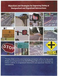 The Office of Safety has recently distributed a series of guide sheets and a brochure describing the 77 intersection safety countermeasures presented in NCHRP Report 500, Volumes 5, A Guide for Addressing Unsignalized Intersection Collisions, and Volume 12, A Guide for Reducing Collisions at Signalized Intersections. The guide sheet packet contains a single front and back sheet on each of the 77 countermeasures and a photograph or drawing of the treatment, along with information including keys to success, implementation issues and time frames, safety effectiveness, costs, and compatibility with other countermeasures. A key sheet is included with each packet of guide sheets. Also, a glove-box size brochure depicting the 77 countermeasures, along with tables on the applicability of each in addressing various crash types, has also been distributed separately.