U.S. Department of Transportation
Federal Highway Administration
1200 New Jersey Avenue, SE
Washington, DC 20590
202-366-4000


Skip to content
Facebook iconYouTube iconTwitter iconFlickr iconLinkedInInstagram

Safety

FHWA Home / Safety / Geometric Design / Publications / Mitigation Strategies For Design Exceptions

Project Location

Several Communities–Seattle, Washington Area

Figure 96.  State Route 99 is an urban arterial in Seattle, Washington.

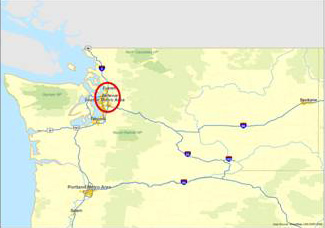
FIGURE 96

State Route 99 is an urban arterial in Seattle, Washington.

Figure 96 is a map of the State of Washington.  The Seattle metropolitan area is circled in red.

Figure 97.   State Route 99 parallels Interstate 5 through the Seattle metro area.  Segments of the highway have been reconstructed through the cities of Shoreline, SeaTac, Des Moines, Kent, and Federal Way.

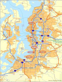
FIGURE 97

State Route 99 parallels Interstate 5 through the Seattle metro area.  Segments of the highway have been reconstructed through the cities of Shoreline, SeaTac, Des Moines, Kent, and Federal Way.

Figure 97 is a map showing the Seattle metropolitan area as well as communities to the north, south, and west.  State Route 99 and Interstate 5 are identified, as are other state highways and interstates in the region.  The communities of Shoreline, SeaTac, Des Moines, Kent, and Federal Way are highlighted with red circles around their names.
 
Back to the Table of Contents
Page last modified on October 15, 2014
Safe Roads for a Safer Future - Investment in roadway safety saves lives
Federal Highway Administration | 1200 New Jersey Avenue, SE | Washington, DC 20590 | 202-366-4000