U.S. Department of Transportation
Federal Highway Administration
1200 New Jersey Avenue, SE
Washington, DC 20590
202-366-4000
State Route (SR) 110 in Los Angeles, constructed in the 1930s, was the first modern freeway on the West Coast (Figure 113). Also known as the Pasadena Freeway, SR 110 was designated a California Historic Parkway in 1993 and renamed the Arroyo Seco Parkway. The Parkway has a number of historic structures (Figure 114) and incorporated many innovative highway design features for its time. It was designated a National Civil Engineering Landmark by the American Society of Civil Engineers in 1999.
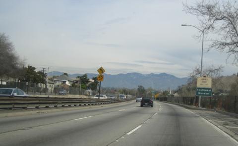
Along some segments of the highway, drivers can experience scenic views of parks, hillsides, and mountains as they travel along the freeway (Figure 115). In 2002, it was designated a National Scenic Byway. In other areas, the highway has a more urban and industrial context. A corridor management plan is being developed to preserve the historic and cultural features along the highway, improve views, and beautify some of the areas in disrepair.
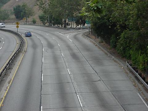
The Arroyo Seco Parkway is a six-lane freeway (three lanes in each direction) and is a major commuter route to downtown Los Angeles. The 2004 Annual Average Daily Traffic (AADT) within the project limits was 105,000 vehicles per day, with a peak hour volume of 8,300 vehicles. The corridor has extremely constrained cross-sectional width. The through travel lanes are 11 feet (3.35 meters) wide, and there are essentially no shoulders (both inside and outside) along much of the corridor (Figure 116). The horizontal alignment is also extremely curvilinear. Much of the Parkway has a posted speed limit of 55 mi/hr, with even higher average operating speeds. Most curves along the corridor do not meet curvature and horizontal stopping sight distance criteria for these speeds and therefore are signed with lower advisory speeds (Figures 115 and 116).
The California Department of Transportation (Caltrans) conducted a 3-year crash analysis for the corridor. The data indicated a crash rate about twice the average rate for similar highway types. There were 1,217 total crashes over this time period. Of these, 324 crashes involved the median barrier, resulting in 111 injuries and 1 fatality. The analysis also showed concentrations of crashes at entrance and exit ramps and concluded that a primary causal factor is the limited acceleration and deceleration lengths.
Several projects are being developed to improve the safety of the Parkway. One of the projects involves replacement of the w-beam median guardrail with concrete barrier. Another project is for geometric improvements at an interchange. There is also a beautification project under development that includes contextually appropriate barriers with fencing on top for access control and other improvements to enhance the appearance and maintainability of the Parkway.
|
|
|
|
|
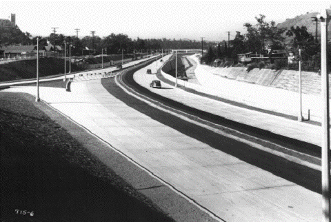
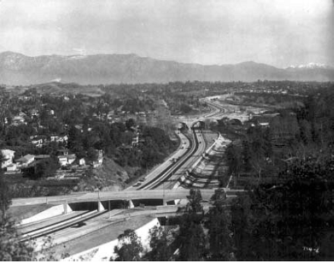
FIGURE 113 SR 110 shortly after construction in 1940. |
Figure 113 consists of two black and white photos, likely taken in the early 1940s, which illustrate the historic and scenic context of the parkway. The top photo shows a new four-lane divided highway with tight entrance and exit ramps. The Arroyo Seco Channel is on the right.
In the bottom photo, an aerial view shows the Parkway extending into the distance toward mountains in the background. An overpass is visible in the foreground, and the Arroyo Seco Channel is on the right. Vegetated hillsides slope up and away from the highway on either side.
 |
 |
|
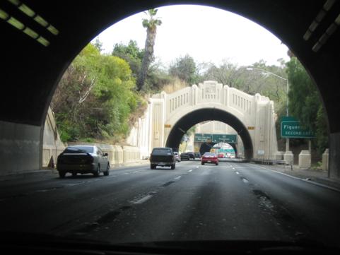
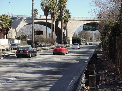
FIGURE 114 |
Figure 114 consists of two photos illustrating historic structures along the parkway. In the top photo, vehicles are entering a series of short arched tunnels with retaining walls on either side. The face of the tunnel entrance and the retaining walls have an art-deco style of architecture. In the bottom photo, vehicles are approaching a tall, concrete arch bridge that passes over the parkway.
 |
|
FIGURE 115 The San Gabriel Mountains on the horizon illustrate the Parkway’s scenic context. |
Figure 115 is a photo showing vehicles traveling on the Parkway with the mountains in the distance.
 |
|
FIGURE 116 The Arroyo Seco Parkway has a narrow cross section, a curvilinear alignment, and non-standard interchange geometry. |