U.S. Department of Transportation
Federal Highway Administration
1200 New Jersey Avenue, SE
Washington, DC 20590
202-366-4000
![]()
| < Previous | Table of Content | Next > |
| Project: road alignment and intersection improvements to two-lane rural road | |||
|---|---|---|---|
| Planned Improvements: |
|
||
| Project Environment: | urban | x suburban | x rural |
| Project Design Stage: | conceptual (0 to 30%) | preliminary (40 to 80%) | x advanced (over 80%) |
| Project Cost: | < $100,000 | $100,000 - $1,000,000 | x >$1,000,000 |
| Project Owner: | Clark County, Washington | ||
| Road Safety Audit | |||
| Date of RSA: | 10-12 May 2005 | ||
| RSA Stage(s): | x design stage | RSA of existing roads | |
| RSA team: | staff from Clark County and Opus Hamilton | ||
PROJECT BACKGROUND:
The improvements to Ward Road, a two-lane rural roadway, were initially motivated by safety concerns resulting from high-severity off-road collisions. Subsequently, the county’s Growth Management Act (1995) resulted in anticipated changes to the road network and hierarchy in the vicinity of the planned improvements, which resulted in the introduction of additional elements to the upgrades. The road improvements were the subject of considerable public interest and input, which have also influenced their design.
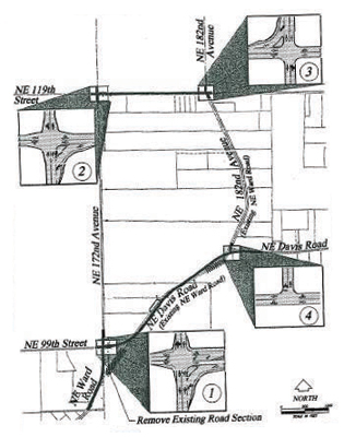
The planned improvements affected three roads: Ward Road (also known as 182 nd Avenue), 172 nd Avenue, and 119 th Street, shown in FIGURE A.6. In addition to functioning as major rural collectors, these roads provided access to adjacent properties (residential and farm) and a small farming town. Improvements, numbered and shown in FIGURE A.7, included:
1) realignment of Ward Road between 172nd Avenue and Davis Road (involving abandonment of an existing road section on structure), and introduction of a new four-way signalized intersection;
2 and 3) intersection improvements at the STOP-controlled intersections of 119th Street / 172nd Avenue and 119th Street / 182nd Avenue, including the introduction of a free right turn lane on one approach;
4) reconfiguration of the existing Ward Road / Davis Road intersection, and relocating the STOP sign from Davis Road to 182nd Street.
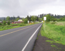 Ward Road near Davis Road |
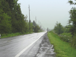 172nd Avenue near Ward Road |
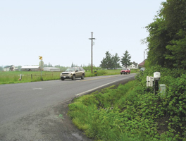 182nd Avenue at 119th Street |
|
FIGURE A.6 VIEWS OF RSA SITE (CLARK COUNTY RSA)
SOURCE: Wallis Engineering
FIGURE A.7 RSA PROJECT (CLARK COUNTY RSA)
At the time of the RSA, the improvements were in the county’s current Transportation Improvement Program, and were in the final design stage. Overall construction costs were estimated at about $9 million, including land acquisition costs.
KEY RSA FINDINGS AND SUGGESTIONS:
The key findings and suggestions of the RSA are summarized in TABLE A.5.
| SELECTED SAFETY ISSUE (Number and Description) |
RISK RATING | SUGGESTIONS | |
|---|---|---|---|
| 1 | New Conflict Points: Traffic on Ward Road will be directed through reconfigured intersections where new traffic control devices and required turn maneuvers will generate an increased potential for rear-end, turning, and merging conflicts. | C |
|
| 2 | Free Right Turn Lanes: Driver workload may be high at free right turn lanes. | B |
|
| 3 | Limited Clear Zones: Limited clear zones increase the risk and potential severity of collisions when drivers leave the travel lanes. | C |
|
| 4 | Limited Sight Distances: Limited sight distance may increase the risk of collision when drivers fail to observe potentially hazardous conditions ahead. | C |
|
| 5 | Signing and Pavement Markings: Proposed signing and pavement markings may not be adequate. | -- | Improve signing and pavement markings for:
|
| 6 | Future Conditions on 172 nd Avenue: Proposed new land use may increase vehicle, pedestrian, and bicycle traffic on the improved roads. | B |
|
| 7 | Opportunities for Interim Improvements | -- |
|
KEY LESSONS LEARNED:
Even at a final design stage, the RSA team may need to identify significant safety issues associated with fundamental design elements. Discussions with County staff indicated that, although improvements to Ward Road were initially proposed primarily to address high-severity off-road collisions, additional issues arose during the lengthy public consultation process concerning the level of traffic considered by different community groups to be suitable on the improved roads. To reconcile the competing desires of these groups, and to provide a forum for the groups to contribute beyond the public consultation stage to the actual design, a Community Design Team (CDT) was established that included representatives of the adjacent communities. The design that was adopted to meet the requirements of the CDT appeared to have expanded beyond the initial safety-related aim of reducing collisions, to include two additional (and potentially competing) aims of controlling traffic speeds by increasing the number of controlled intersections through which traffic would pass, and achieving a redistribution of traffic that the CDT deemed equitable. Although the County’s efforts to include the public in the design process were in many ways laudable, the resulting reconfiguration of intersections and introduction of new traffic control devices were expected to compromise traffic safety by introducing additional conflict points (see Issues 1 and 2 in TABLE A.5). The RSA team felt it necessary to point out that that net result of directing formerly free-flowing traffic through controlled intersections was expected to be decreased severity, but increased frequency, of collisions compared with existing conditions. As a result of the RSA, County engineering staff started a re-examination of major elements of the project, which they expected would lead to a safer project at considerably less expense.
RSAs can contribute to achieving pre-existing roadway safety goals. This FHWA-sponsored RSA contributed to the achievement of the Washington Traffic Safety Commission’s Target Zero: A Strategic Plan for Highway Safety 2000, a statewide traffic safety plan supporting the achievement of a transportation system without deaths or disabling injuries. Specifically, one of the Target Zero emphasis areas was the road environment. Strategies in this area that the RSA supported included improving signing and delineation, and training county traffic engineers and planners to identify traffic safety problems and develop solutions. As a pilot implementation of a potential state-wide program of RSAs, it may also have helped to promote the Target Zero strategy to develop programs and partnerships to implement safety projects for local roadways.
See also the discussion of “Key Factors for Success” and “Lessons Learned” in the main text.
| < Previous | Table of Content | Next > |

