Road Safety Audits (RSA)

Aquetong/Windy Bush Roads – Road Safety Audit Report
Appendix A: Audit Team
| Name |
Organization |
| Rosemarie Anderson |
Delaware Valley Regional Planning Commission |
| Dominick Bellizzie |
Solebury Township Police Department |
| Larry Bucci |
Pennsylvania Department of Transportation |
| Dennis Carney |
Solebury Township |
| Michael Castellano |
Federal Highway Administration |
| Joe Fiocco |
McMahon Associates – Solebury Township |
| Carmine Fiscina |
Federal Highway Administration |
| John Granger |
Solebury Township |
| David Johnson |
Bucks County Planning Commission |
| Regina Moore |
Delaware Valley Regional Planning Commission |
| Brooke Moran |
Bucks County Area Agency on Aging |
| Kevin Murphy |
Delaware Valley Regional Planning Commission |
| Mark Roth |
McMahon Associates |
| Derrick Sexton |
Delaware Valley Regional Planning Commission |
| Karen Yunk |
Federal Highway Administration |
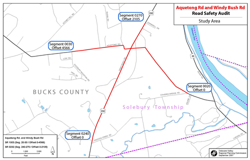
Appendix B: Maps
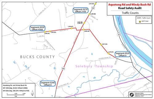
Appendix C: Traffic Data
RSA AQUETONG AND WINDYBUSH ROADS, BUCKS COUNTY
- Date Range: 1/1/2003 to 12/31/2006
- Area of Interest: (In County 09 On State Route 0232(P) Between Segment 0270 Offset 0 and Segment 0270 Offset 2105) or (In County On State Route 1003(P) Between Segment 0020 Offset 0 and Segment 0030 Offset 4566)
- User ID/Query ID: lkubli/0620070602001
MONTH OF YEAR
| |
JAN |
FEB |
APR |
MAY |
JUL |
AUG |
SEP |
NOV |
DEC |
|
| CRASHES |
3 |
5 |
4 |
3 |
2 |
2 |
3 |
1 |
2 |
25 |
| PCT |
4% |
20% |
16% |
12% |
8% |
8% |
12% |
4% |
8% |
100% |
DAY OF WEEK
| |
SUN |
MON |
TUE |
WED |
THR |
FRI |
SAT |
|
| CRASHES |
6 |
1 |
2 |
1 |
3 |
7 |
5 |
25 |
| PCT |
24% |
4% |
8% |
4% |
12% |
25% |
20% |
100% |
HOUR OF DAY
| |
03 |
06 |
07 |
08 |
09 |
10 |
11 |
12 |
13 |
14 |
15 |
16 |
17 |
18 |
19 |
20 |
21 |
22 |
|
| CRASHES |
1 |
1 |
1 |
1 |
1 |
2 |
1 |
1 |
1 |
3 |
2 |
1 |
3 |
1 |
1 |
2 |
1 |
1 |
25 |
| PCT |
4% |
4% |
4% |
4% |
4% |
8% |
4% |
4% |
4% |
12% |
8% |
4% |
12% |
4% |
4% |
8% |
4% |
4% |
100% |
YEAR
| |
CRASHES |
PCT |
| 2003 |
16 |
64% |
| 2004 |
2 |
8% |
| 2005 |
7 |
28% |
| TOTAL |
25 |
100% |
COLLISION TYPE
| |
CRASHES |
PCT |
| ANGLE |
12 |
48% |
| HAPPY FIX OBJ |
7 |
28% |
| OPP DIR SS |
2 |
8% |
| HEAD ON |
1 |
4% |
| NON COLL |
1 |
4% |
| PEDESTRIAN |
1 |
4% |
| REAR END |
1 |
4% |
| TOTAL |
25 |
100% |
CRASH SEVERITY LEVEL
| |
CRASHES |
PCT |
| MAJOR |
1 |
4% |
| MODERATE |
3 |
12% |
| MINOR |
7 |
28% |
| PDO |
14 |
56% |
| TOTAL |
25 |
100% |
SEVERITY COUNT
| |
PERSONS |
| FATALITIES |
0 |
| MOAJOR |
1 |
| MODERATE |
3 |
| MINOR |
11 |
| UNK SEVERITY |
0 |
| UNK IF INJURED |
0 |
DRIVER ACTIONS
| |
ACTIONS |
PCT |
| NO CONTRIBUTING ACTION |
36 |
40% |
| RUNNING STOP SIGN |
10 |
11% |
| TOO FAST FOR CONDITION |
10 |
11% |
| OTHER IMPROPER DRIVING |
9 |
10% |
| OVER/UNDER COMP CURVE |
7 |
7% |
| PROCEED W/O CLEARANCE |
7 |
7% |
| WRONG SIDE OF ROADWAY |
6 |
6% |
| AFFEDTED PHYSICAL COND |
2 |
2% |
| RUNNING RED LIGHT |
2 |
2% |
| SPEEDING |
1 |
1% |
| TOTAL |
90 |
100% |
VEHICLE TYPE
| |
VEHICLES |
PCT |
| AUTOMOBILE |
25 |
58% |
| SUV |
9 |
20% |
| VAN |
4 |
9% |
| SMALL TRUCK |
3 |
6% |
| MOTORCYCLE |
1 |
2% |
| LARGE TRUCK |
1 |
2% |
| CONSTRUCTION |
1 |
2% |
| TOTAL |
43 |
100% |
ROAD CONDITION
| |
CRASHES |
PCT |
| DRY |
11 |
44% |
| WET |
9 |
36% |
| SNOW |
4 |
16% |
| UNK |
1 |
4% |
| TOTAL |
43 |
100% |
ILLUMINATION
| |
CRASHES |
PCT |
| DAYLIGHT |
16 |
64% |
| DARK |
7 |
28% |
| DUSK |
1 |
4% |
| UNK |
1 |
4% |
| TOTAL |
25 |
100% |
WEATHER
| |
CRASHES |
PCT |
| CLEAR |
15 |
60% |
| RAIN |
4 |
16% |
| SNOW |
3 |
12% |
| UNK |
2 |
8% |
| SLEET |
1 |
4% |
| TOTAL |
25 |
100% |
ENVIR/ROADWAY FACTORS
| |
FACTORS |
PCT |
| NONE |
22 |
88% |
| DEER IN ROADWAY |
1 |
4% |
| SLIPPERY ICE/SNOW |
1 |
4% |
| UNKNOWN |
1 |
4% |
| TOTAL |
25 |
100% |
CDART - Crash Summary Report (09-05)
NOTES:
-
The data available in this application is dynamic and should be used with care. Please take note of the following data alerts
-
2007 crash records are incomplete
Data for the current year, 2007, is not fully represented in CDART. Crashes will be added for this year as they are made available to the Department. Include this year in queries with caution
-
Complete data years
Complete records of reportable crashes are available for the following years: 1997, 1998, 1999, 2000, 2001, 2002, 2003, 2004, 2005, 2006
REPORT PARAMETERS:
Query ID: 0620070602001
User ID: lkubli
Area of Interest: (in County 09 On State Route 0232(P) Between Segment 0270 Offset 0 and Segment 2105) or (In County 09 On State Route 1003(P) Between Segment 0020 Offset 0 and Segment 0030 Offset 4566)
Criteria: STATE ROAD
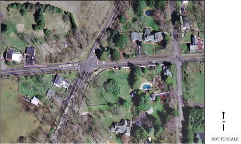
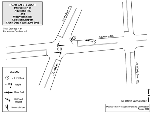
1. Intersection of Aquetong Rd. and Windy Bush Rd., Study Area Limits
Aquetong Rd. (seg 20/0 to seg 30/4566), Windy Bush Rd. (seg 270/0 to seg 270/2105)
 |
COLLISION TYPE
| Angle |
12 |
| Hit Fixed Object |
7 |
| Opp Dir Sideswipe |
2 |
| Rear end |
1 |
| Head On |
1 |
| Pedestrian |
1 |
| Non Collision |
1 |
| Total |
25 |
|
ILLUMINATION
| Daylight |
16 |
| Dark |
7 |
| Dusk |
1 |
| Unknown |
1 |
| Total |
25 |
|
WEATHER
| Clear |
15 |
| Rain |
4 |
| Snow |
3 |
| Unknown |
2 |
| Sleet |
1 |
| Total |
25 |
|
SEVERITY COUNT
| Fatalities |
0 |
| Major |
1 |
| Moderate |
3 |
| Minor |
11 |
|
Road Safety Audit - FY 2008
2. Aquetong Rd. East of the Intersection
- Year Range: 2003 to 2005
- Area of: In County: 9
- On Route: 1003
- Between Segment: 20
- Offset: 980
- and Segement: 20
- Offset: 4604
| COLLISION TYPE |
| Hit fixed object |
3 |
50% |
| Opp Dir Sideswipe |
2 |
33% |
| Hit pedestrian |
1 |
17% |
| Total |
6 |
|
| SEVERITY LEVEL |
| Not injured |
4 |
67% |
| Moderate injury |
2 |
33% |
| Total |
6 |
|
| SEVERITY COUNT |
| Fatalities |
0 |
|
| Major |
0 |
|
| Moderate |
2 |
|
| Minor |
1 |
|
| UNK Severity |
0 |
|
| UNK If |
0 |
|
| ENVIR/ROADWAY FACTORS |
| None |
4 |
67% |
| Slippery road conditions |
1 |
17% |
| Unknown |
1 |
17% |
| Total |
4 |
|
| ROAD CONDITION |
| Dry |
1 |
17% |
| Snow covered |
4 |
67% |
| Unknown (expired) |
1 |
17% |
| Total |
6 |
|
| WEATHER |
| No adverse conditions |
– |
17% |
| Sleet (hal) |
– |
17% |
| Snow |
3 |
50% |
| Unknown |
– |
17% |
| Total |
6 |
|
| ILLUMINATION |
| Daylight |
2 |
33% |
| Dark - no street lights |
3 |
50% |
| Unknown |
– |
17% |
| Total |
6 |
|
| DRIVER ACTIONS |
| Driving on the wrong side of roadway |
2 |
25% |
| Over or under compensation at curve |
2 |
25% |
| Driving too fast for conditions |
4 |
50% |
| Total |
8 |
|
| VEHICLE TYPE |
| Automobile |
6 |
67% |
| Small truck |
– |
11% |
| SUV |
2 |
22% |
| Total |
9 |
|
| YEAR |
| 2003 |
3 |
50% |
| 2005 |
3 |
50% |
| Total |
6 |
|
| MONTH |
| JAN |
3 |
50% |
| FEB |
2 |
33% |
| DEC |
1 |
17% |
| Total |
6 |
|
| DAY OF WEEK |
| SUN |
4 |
67% |
| WED |
1 |
17% |
| SAT |
1 |
17% |
| Total |
26 |
|
| HOUR OF DAY |
| 10 |
1 |
17% |
| 14 |
1 |
17% |
| 15 |
1 |
17% |
| 18 |
1 |
17% |
| 19 |
1 |
17% |
| 22 |
1 |
17% |
| Total |
6 |
|
2. Aquetong Rd. East of the Intersection
Segment 20, Offset 980 to Segment 20, Offset 4604
 |
COLLISION TYPE
| Angle |
12 |
| Hit Fixed Object |
7 |
| Opp Dir Sideswipe |
2 |
| Rear end |
1 |
| Head On |
1 |
| Pedestrian |
1 |
| Non Collision |
1 |
| Total |
25 |
|
ILLUMINATION
| Daylight |
16 |
| Dark |
7 |
| Dusk |
1 |
| Unknown |
1 |
| Total |
25 |
|
WEATHER
| Clear |
15 |
| Rain |
4 |
| Snow |
3 |
| Unknown |
2 |
| Sleet |
1 |
| Total |
25 |
|
SEVERITY COUNT
| Fatalities |
0 |
| Major |
1 |
| Moderate |
3 |
| Minor |
11 |
|
Road Safety Audit - FY 2008
3. Intersection of Aquetong Rd. and Windy Bush Rd.
- Year Range: 2003 to 2005
- Between Segment: 30
- Area of: In County: 9
- and Segement: 30
- On Route: 1003
- Offset: 341
| COLLISION TYPE |
| Angle |
10 |
71% |
| Hit fixed object |
2 |
14% |
| Rear-end |
1 |
7% |
| non collision |
1 |
7% |
| Total |
14 |
|
| SEVERITY LEVEL |
| Not injured |
7 |
50% |
| Major injury |
1 |
14% |
| Moderate injury |
1 |
7% |
| Minor injury |
5 |
7% |
| Total |
14 |
|
| SEVERITY COUNT |
| Not injured |
0 |
|
| Major injury |
1 |
|
| Moderate injury |
1 |
|
| Minor injury |
8 |
|
| Major injury |
0 |
|
| Moderate injury |
0 |
|
| ENVIR/ROADWAY FACTORS |
| None |
13 |
93% |
| Major injury |
1 |
7% |
| Total |
14 |
|
| ROAD CONDITION |
| Dry |
9 |
64% |
| Wet |
5 |
36% |
| Total |
14 |
|
| WEATHER |
| No adverse conditions |
10 |
71% |
| Rain |
3 |
21% |
| Unknown |
1 |
7% |
| Total |
14 |
|
| ILLUMINATION |
| Daylight |
11 |
79% |
| Dark - no street lights |
2 |
14% |
| Dusk |
1 |
7% |
| Total |
14 |
|
| DRIVER ACTIONS |
| Proceeding who clearance after stop |
2 |
13% |
| Running stop sign |
5 |
31% |
| Running red light |
1 |
6% |
| Over or under compensation at curve |
1 |
6% |
| Speeding |
1 |
6% |
| Driving too fast for coditions |
1 |
6% |
| Affected by Physical Condition |
2 |
13% |
| Other improper driving actions |
3 |
19% |
| Total |
16 |
|
| VEHICLE TYPE |
| Automobile |
13 |
50% |
| Motorcycle |
1 |
4% |
| Small truck |
1 |
4% |
| Large truck |
1 |
4% |
| SUV |
6 |
23% |
| Van |
3 |
12% |
| Construction |
1 |
4% |
| Total |
26 |
|
| YEAR |
| 2003 |
10 |
71% |
| 2005 |
2 |
14% |
| 2006 |
2 |
14% |
| Total |
14 |
|
| MONTH |
| FEB |
3 |
21% |
| APR |
2 |
14% |
| MAY |
2 |
14% |
| JUL |
2 |
14% |
| AUG |
2 |
14% |
| SEP |
2 |
14% |
| DEC |
1 |
7% |
| Total |
14 |
|
| DAY OF WEEK |
| SUN |
1 |
50% |
| MON |
1 |
4% |
| TUE |
2 |
4% |
| THR |
2 |
23% |
| FRI |
5 |
12% |
| SAT |
3 |
4% |
| Total |
26 |
|
3. Intersection of Aquetong Rd. and Windy Bush Rd.
Segment 30, Offset 266 to Segment 30, Offset 341
 |
COLLISION TYPE
| Angle |
10 |
| Hit Fixed Object |
2 |
| Non Collision |
1 |
| Rear-end |
1 |
| Total |
14 |
|
ILLUMINATION
| Daylight |
11 |
| Dark - no street lights |
2 |
| Dusk |
1 |
| Total |
14 |
|
WEATHER
| Clear |
10 |
| Rain |
3 |
| Unknown |
1 |
| Total |
14 |
|
SEVERITY COUNT
| Fatalities |
0 |
| Major |
1 |
| Moderate |
1 |
| Minor |
8 |
|
Road Safety Audit - FY 2008
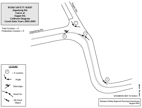
4. Aquetong Rd. Curve at Sugan Rd.
- Year Range: 2003 to 2005
- Area of: In County: 9
- On Route: 1003
- Between Segment: 30
- Offset: 823
- and Segement: 30
- Offset: 1154
| COLLISION TYPE |
| Angle |
2 |
50% |
| Hit fixed object |
1 |
25% |
| Head-on |
1 |
25% |
| Total |
4 |
|
| SEVERITY LEVEL |
| Not injured |
3 |
75% |
| Major injury |
1 |
25% |
| Total |
4 |
|
| SEVERITY COUNT |
| Fatalities |
0 |
|
| Major |
0 |
|
| Moderate |
0 |
|
| Minor |
1 |
|
| UNK Severity |
0 |
|
| UNK If |
0 |
|
| ENVIR/ROADWAY FACTORS |
| None |
4 |
100% |
| Total |
4 |
|
| ROAD CONDITION |
| Dry |
1 |
25% |
| Wet |
3 |
75% |
| Total |
4 |
|
| WEATHER |
| No adverse conditions |
3 |
75% |
| Rain |
1 |
25% |
| Total |
4 |
|
| ILLUMINATION |
| Daylight |
3 |
75% |
| Dark - no street lights |
1 |
25% |
| Total |
4 |
|
| DRIVER ACTIONS |
| Proceeding who clearance after stop |
1 |
20% |
| Driving on the wrong side of the roadway |
1 |
20% |
| Driving too fast for coditions |
2 |
40% |
| Other improper driving actions |
1 |
20% |
| Total |
5 |
|
| VEHICLE TYPE |
| Automobile |
6 |
75% |
| SUV |
1 |
13% |
| Van |
1 |
13% |
| Total |
8 |
|
| YEAR |
| 2003 |
2 |
50% |
| 2005 |
2 |
50% |
| Total |
4 |
|
| MONTH |
| APR |
1 |
25% |
| MAY |
1 |
25% |
| SEP |
1 |
25% |
| NOV |
1 |
25% |
| Total |
4 |
|
| DAY OF WEEK |
| THR |
1 |
25% |
| FRI |
2 |
50% |
| SAT |
1 |
25% |
| Total |
4 |
|
| HOUR OF DAY |
| 10 |
1 |
25% |
| 14 |
1 |
25% |
| 15 |
1 |
25% |
| 17 |
1 |
25% |
| Total |
4 |
|
4. Aquetong Rd. Curve at Sugan Rd.
Segment 30, Offset 823 to Segment 30, Offset 1154
 |
COLLISION TYPE
| Angle |
2 |
| Hit Fixed Object |
1 |
| Head On |
1 |
| Total |
4 |
|
ILLUMINATION
| Daylight |
3 |
| Dark - no street lights |
1 |
| Total |
4 |
|
WEATHER
| Clear |
3 |
| Rain |
1 |
| Total |
4 |
|
SEVERITY COUNT
| Fatalities |
0 |
| Minor |
1 |
|
Road Safety Audit - FY 2008
5. Aquetong Rd. West of the Intersection
- Year Range: 2003 to 2005
- Area of: In County: 9
- On Route: 1003
- Between Segment: 30
- Offset: 2000
- and Segement: 30
- Offset: 4566
| COLLISION TYPE |
| Hit fixed object |
1 |
100% |
| Total |
1 |
|
| SEVERITY LEVEL |
| Minor injury |
1 |
100% |
| Total |
1 |
|
| SEVERITY COUNT |
| Fatalities |
0 |
|
| Major |
0 |
|
| Moderate |
0 |
|
| Minor |
1 |
|
| UNK Severity |
0 |
|
| UNK If injured |
0 |
|
| ENVIR/ROADWAY FACTORS |
| None |
1 |
100% |
| Total |
|
|
| ROAD CONDITION |
| Wet |
1 |
100% |
| Total |
1 |
|
| WEATHER |
| No adverse conditions |
1 |
100% |
| Total |
1 |
|
| ILLUMINATION |
| Dark - no street lights |
1 |
100% |
| Total |
1 |
|
| DRIVER ACTIONS |
| Other improper driving actions |
1 |
100% |
| Total |
1 |
|
| VEHICLE TYPE |
| Small truck |
1 |
100% |
| Total |
1 |
|
| YEAR |
| 2003 |
1 |
100% |
| Total |
1 |
|
| MONTH |
| APR |
1 |
100% |
| Total |
1 |
|
| DAY OF WEEK |
| SUN |
1 |
100% |
| Total |
1 |
|
| HOUR OF DAY |
| 20 |
1 |
100% |
| Total |
1 |
|
5. Aquetong Rd. West of the Intersection
Segment 30, Offset 2000 to Segment 30, Offset 4566
 |
COLLISION TYPE
| Hit Fixed Object |
1 |
| Total |
1 |
|
ILLUMINATION
| Dark - no street lights |
1 |
| Total |
1 |
|
|
SEVERITY COUNT
| Fatalities |
0 |
| Minor |
1 |
|
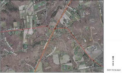
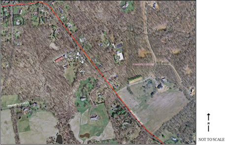
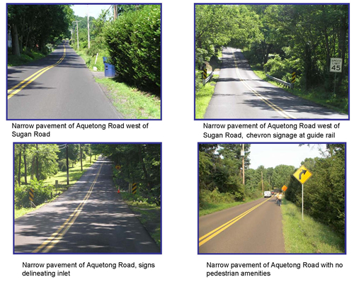
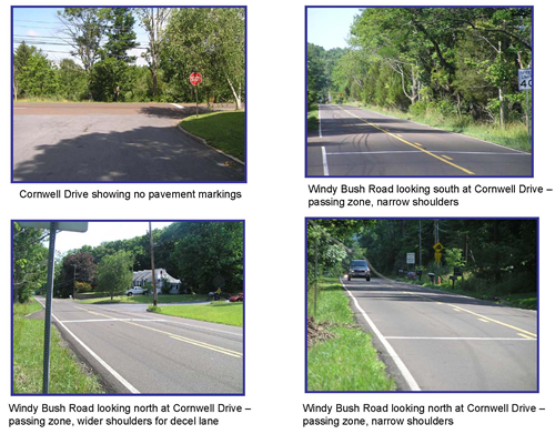
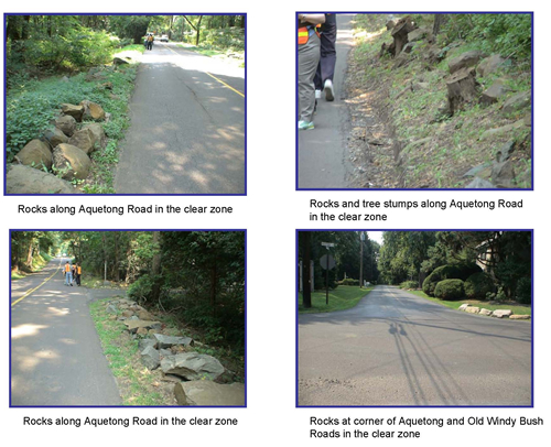
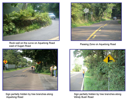
Appendix D: Photo Log
Appendix E: Checklist
CHECKLIST
Audit Team Member
GENERAL ISSUES
| Item # |
Description |
Check |
Comments |
| 1 Drainage |
Do drainage items seem to be adequate? |
|
|
| Are drainage items clear of debris? |
|
|
| 2 Landscaping |
Is landscaping in accordance with guidelines (sight distance, clearances etc.) |
|
|
| 3 Public Utilities |
Are boxes, poles, and/or posts located in a safe position? |
|
|
| Do the above items interfere with sight distance? |
|
|
| 4 Access Management |
Are there locations where access management is problematic? |
|
|
| 5 Lighting |
Is lighting needed in specific locations? |
|
|
ALIGNMENT AND CROSS SECTION
| Item # |
Description |
Check |
Comments |
| 1 Visibility |
Are sight distances adequate for the speed of traffic on Aquetong Rd.? |
|
|
| Is adequate sight distance provided at intersections? |
|
|
| Are sight distances adequate for the speed of traffic on Aquetong Rd? |
|
|
| 2 Driver expectation |
Are there any sections of the roadway which may cause driver confusion such as: |
|
|
| a. Is alignment of roadway clearly defined? |
|
|
| b. Are crossroads or hidden driveways properly signed along corridor? |
|
|
| c. Are curves properly delineated? |
|
|
| 3 Widths |
Are all the traffic lanes and roadway widths adequate? |
|
|
| 4 Design Speed |
Is the horizontal and vertical alignment
suitable for traffic speed? If not: |
|
|
| a. Are advisory speed signs posted? |
|
|
| b. Are warning signs installed? |
|
|
| c. Are posted advisory speeds for curves appropriate? |
|
|
| 5 Shoulders |
Is the shoulder cross slope sufficient to provided proper drainage? |
|
|
| Are there locations where guide rail may be appropriate? |
|
|
| 6 Overtaking |
Are adequate passing opportunities provided? |
|
|
INTERSECTIONS
| Item # |
Description |
Check |
Comments |
| 1 Location |
Are there any roadside objects nearby which would intrude on driver's line of sight? |
|
|
| Are the intersections adequate for all vehicular movements? |
|
|
| Are intersections located safely with respect to horizontal and vertical alignment? |
|
|
| 2 Controls |
Are pavement markings and intersection control signing satisfactory? |
|
|
| 3 Signage |
Is the intersection appropriately signed? |
|
|
| Are there advance warning signs indicating the intersection? |
|
|
| Are signs appropriately located and of the appropriate size |
|
|
| 4 Layout |
Is the intersection layout obvious to all users? |
|
|
| Are turning radii and tapers appropriate? |
|
|
| Are driveways located at or near the intersections? |
|
|
| 5 Visibility, sight distance |
Is sight distance adequate for all movements and all users? |
|
|
TRAFFIC SIGNALS
| Item # |
Description |
Check |
Comments |
| 1 Signal Operation |
Are traffic signals operating correctly? (Example clearance time) |
|
|
| 2 Visibility |
Are traffic signals clearly visible to approaching motorists? |
|
|
PEDESTRIANS
| Item # |
Description |
Check |
Comments |
| 1 Pedestrians |
Are there any roadside objects nearby which would intrude on driver's line of sight? |
|
|
BICYCLISTS
| Item # |
Description |
Check |
Comments |
| 1 Bicyclists |
Are there share the road signs posted? |
|
|
| Is the road surface of suitable quality for bicyclists? |
|
|
SIGNAGE, PAVEMENT MARKINGS, DELINEATION AND LIGHTING
| Item # |
Description |
Check |
Comments |
| 1 Signage |
Are there signs missing from key locations? |
|
|
| Are signs easy to understand? |
|
|
| Are the correct signs used for each situation, and is each sign necessary? |
|
|
| Are signs effective for all likely conditions (i.e. day, night, oncoming headlights etc)? |
|
|
| Are all necessary regulatory, warning, and direction signs (including detours) in place? Are they conspicuous? |
|
|
| 2 Pavement Markings and Delineation |
Does existing pavement markings need to be re-painted? |
|
|
| Have raised pavement markers been installed? |
|
|
| Are pavement markings easily visible and effective for all likely conditions (i.e. at night, day, inclement weather etc.)? |
|
|
| Are guide posts correctly placed, clean, and visible? |
|
|
| Are there locations where chevrons are needed? |
|
|
| 3 Lighting |
Is appropriate lighting installed at intersections, pedestrian and bicycle crossings? |
|
|
| Are the appropriate types of poles used for all locations and correctly installed? |
|
|
| Are all locations free of any lighting which may conflict visually with signs? |
|
|
PAVEMENT
| Item # |
Description |
Check |
Comments |
| 1 Pavement defects |
Is the pavement free of defects (i.e. excessive roughness, potholes) which could result in safety problems? |
|
|
| 2 Ponding |
Is the pavement free of areas where ponding may occur resulting in a safety problem? |
|
|
| 3 Skid resistance |
Are the correct signs used for each situation, and is each sign necessary? |
|
|
Appendix F: Response Sheet
Aquetong/Windy Bush Roads – Road Safety Audit
CORRIDOR WIDE
| SAFETY ISSUES |
Solution |
Decision Agree/Reject |
Planned Completion Date |
Comments |
| Drainage |
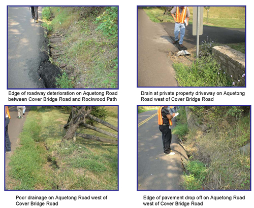
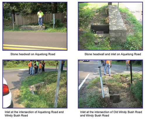
- Poor drainage or the lack of a proper drainage system in the corridor has resulted in a number of safety issues. Potentially resulting in sheeting across roadway during inclement weather.
- Edge of roadway eroded due to wash out.
- Swells need to be cut back, near S curve east of Sugan Road
- Pipes are clogged, some are not visible (due to debris)
|
- Conduct a comprehensive drainage study for the corridor to identify specific issues and long term solutions. Consideration should be given to additional pipes and new parallel drainage systems.
- In the short term: clean clogged pipes and remove debris from the drains.
- In addition, where possible excavate and fill in with ballast (rocks).
|
|
|
|
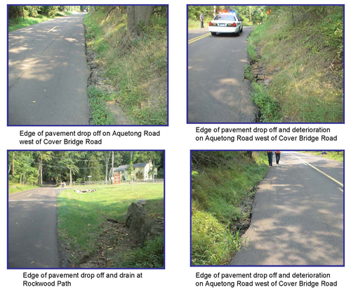
| Edge Lines and Edge Drop-offs |
- Lack of edge of pavement delineation is consistent through the corridor. In addition, edge drop offs are consistently evident. This is a result of the poor drainage control.
|
- Install edge line as appropriate throughout the corridor to guide motorists and prevent run of the road crashes.
PennDOT should consider minimum 9.5 foot lanes as a safety measure |
|
|
|
| Fixed objects |
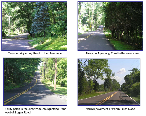
- Numerous fixed objects were observed in the clear zone. These included trees (large and small); boulders (many used for landscaping by property owners and, stone headwalls (approx. 3 feet above the ground)
|
- All fixed objects in the clear zone should be removed. Initial clearing should be at least four feet from edge of travel.
Many trees along the corridor were already marked for removal |
|
|
|
| Narrow roadway width |
- Roadway width throughout the study area on Aquetong and Windy Bush Roads varied between 9 and 10 feet
|
- All fixed objects in the clear zone should be removed. Initial clearing should be at least four feet from edge of travel.
Many trees along the corridor were already marked for removal |
|
|
|
| Vegetation |
- Trees and shrubs obstruct the view of many signs throughout the corridor and interfere with sight lines
|
|
|
|
|
| Centerline Delineation |
- The corridor is shadowed during the day due to the canopy of trees and extremely dark at night, a result of the lack of street lighting. Coupled with narrow pavement width.
|
- Install raised pavement markers (RPM) the length of the corridor to keep the motorist in his travel lane. Installation of centerline rumble strips to assist in the prevention of cross-over head-on collisions were examined but the narrowness of the travel lanes negates this treatment.
|
|
|
|
| Speed Limit |
- Given the geometry of the corridor, the set speed limit of 45 MPH may be excessive
|
A speed study was conducted by PennDOT; as a result, the speed limit will be lowered along Aquetong Road from River Road to Sawmill Road to 35 MPH |
|
|
|
| Passing Zones |
- There are too many passing zones in the corridor given the narrow lanes and edge drop offs which are not forgiving if motorist overcompensate while passing.
|
|
|
|
|
| Signs |
- No “Share the Road” signs.
- Construction signs located along Aquetong Road with no construction being conducted
- No name plates for advance intersection signs
|
- Install “Share the Road” signs throughout the corridor so motorists are cognizant of other users.
- Remove or cover construction signs at times when there is no work being conducted on the roadway.
- Add street name plates to advance intersection signs
- Add advance signs for hidden driveways as appropriate
|
|
|
|
| Pavement Markings |
- Several intersection approaches with stop control do not have stop bars
|
- Install stop bars to intersection approaches as appropriate
Many trees along the corridor were already marked for removal |
|
|
|
| Sight Lines |
|
- Maximize sightlines around curves by cutting back embankment and removing trees.
|
|
|
|
SPECIFIC LOCATIONS
| SAFETY ISSUES |
Solution |
Decision Agree/Reject |
Planned Completion Date |
Comments |
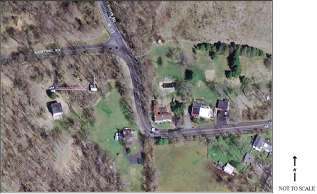
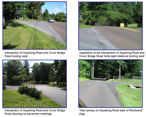
| At Covered Bridge Road |
- Covered Bridge Road is skewed at the intersection with Aquetong Road. Additionally, there are no pavement markings at the Covered Bridge Road approach.
|
- Use pavement markings to soften skew allowing easier access to Aquetong Road especially for left turning traffic
|
|
|
|
- Utility pole to the west of the intersection on Aquetong Road obstructs sight lines.
|
|
|
|
|
- Rail fence west of intersection on Aquetong Road next to parking lot is in Right of Way.
|
- Relocate fence outside Right of Way.
Fence will be removed as part of new development
|
|
|
|
| At Rockwood Path |
- Tree to the west of the intersection blocks sight lines for Rockwood Path approach traffic
|
|
|
|
|
| Between Rockwood Path and Wagner Road (private road) |
- “Curve ahead” (W1-2) sign is too far from the actual curve and is faded
|
- Upgrade sign (W1-2) and relocate closer to curve
|
|
|
|
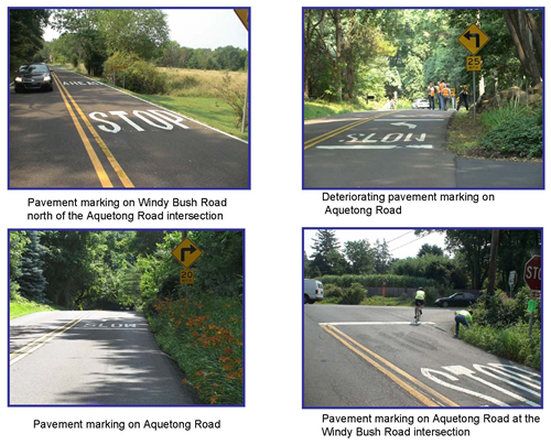
- “Slow Curve Ahead” pavement markings are too far from curve and are wearing out
|
- Add pavement marking legend closer to curve and repaint existing ones.
|
|
|
|
- Eastbound “No Passing” (W14-3) sign knocked down
|
|
|
|
|
- Hidden driveway at the curve
|
- Install advance warning sign for driveway.
|
|
|
|
- Night time driving difficult due to the darkness which could makes negotiating the curve difficult.
|
- Install lighting on curve
|
|
|
|
- Illegal speed limit sign is installed within the ROW eastbound before the curve
|
|
|
|
|
| Between Wagner Road (private road) and Old Windy Bush Road |
- Junction sign is blocked by tree limbs
|
- Trim tree limbs
- Relocate street name sign to the post assembly of “Stop Ahead” (W3-1) sign
|
|
|
|
- Cut off sign posts are protruding out of the ground
|
|
|
|
|
| At Old Windy Bush Road |
- “Stop Ahead” sign is blocked by vegetation
|
|
|
|
|
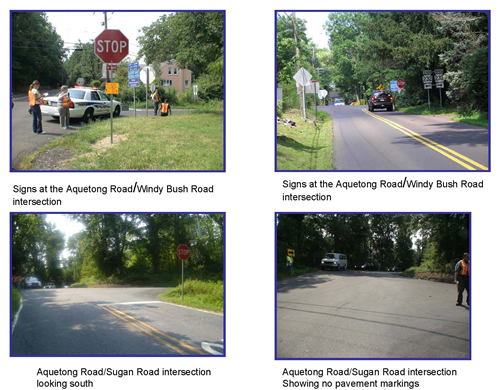
| At Windy Bush Road |
- Sign clutter, potentially confusing to motorists
|
- Remove or consolidate signs as appropriate
|
|
|
|
- Westbound approach to intersection, poor sight distance which is made worse by vegetation
|
- Cut away vegetation to improve sight distance
|
|
|
|
- Northeast, northwest and southwest corners of intersection has unprotected drainage holes that lead to pipe
|
- Install protective grates
|
|
|
|
| Windy Bush Road between Old Windy Bush and Aquetong Road |
- “Intersection ahead” sign on northbound side of the road is blocked by vegetation
|
|
|
|
|
- No advance street name sign for the Aquetong Road intersection
|
- Install advance “Aquetong Road” sign (W16-8)
|
|
|
|
| Old Windy Bush Road at Windy Bush Road |
- Drainage hole on the southeast corner
|
|
|
|
|
- Utility pole lying on the ground at the southeast corner of the intersection.
|
|
|
|
|
| Between Windy Bush Road and Sugan Road |
- Aquetong Road is an S-curve in this area with post mounted warning signs only
|
- Add “Slow Curve Ahead” pavement markings in both direction
|
|
|
|
- Vegetation on the westbound side of the road conceals the edge of pavement
|
|
|
|
|
- Edge drop off in this section of roadway is pronounced as a result of poor drainage
|
- Currently a PennDOT project to excavate and fill with rocks.
- This is a temporary fix and in the long term proper drainage should be installed including pipes
|
|
|
|
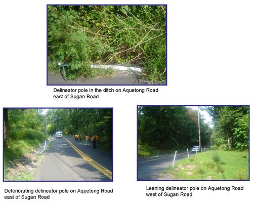
- Reflector poles are in poor condition. Reflector strips have been stripped from the poles and many are down in the drain
|
- Replace with chevrons (W1-8)
|
|
|
|
- Aquetong Road westbound curves while Sugan Road continues straight ahead,
|
- Add graphic directional
signage with road names
|
|
|
|
| At Sugan Road |
- At Sugan Road the intersection is on the curve and very wide. Additionally, travel lanes are not delineated
|
- Add dashed double centerline and single edgeline through intersection. This will alleviate driver confusion
|
|
|
|
- Curve needs to be delineated
|
- Add large warning arrow (W1-6) on the curve for eastbound Aquetong Road traffic
|
|
|
|
| Between Sugan Road and Solebury Mountain Road |
- Oversized drainage pipes installed by property owners at driveways are unprotected hazards in the clear zone. Some pipes include headwalls.
|
- Install appropriate drainage pipes according to regulation.
|
|
|
|
| Windy Bush Road between Aquetong Road and Pidcock Creek Road |
- Open pipe culvert on the side of the road result in unprotected curb drop off.
|
- Widen road to 12-foot lanes with paved shoulder to eliminate open pipe culvert that parallels the road.
|
|
|
|
- Property owners have installed a variety of drainage pipes and sizes at driveways. They are unprotected hazards in the clear zone and some pipes include headwalls.
|
- Install appropriate drainage pipes according to regulation.
|
|
|
|
- Pipes at property owners driveways are clogged with debris
|
- Clear pipes to prevent flooding on the roadway
|
|
|
|
- Guide rail needs to be updated
|
- Replace guide rail with upgraded end treatments.
|
|
|
|
Title of Report: AQUETONG/WINDY BUSH ROADS - ROAD SAFETY AUDIT
Publication No.: 07042A
Date Published: October 2007
Geographic Area Covered:
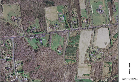
The study area includes sections of Aquetong Road (SR 1003) and Windy Bush Road (SR 232) in Bucks County, Pennsylvania.
Key Words:
Road, safety, audit, potential, fatalities, injuries, reportable, crashes, issues, strategies, coordination, engineering, enforcement, education, prioritize, intersection, speed limit, traffic volumes, PennDOT, stakeholders, audit team, curve, sight distance, clear zone, geometry, pavement markings, signs.
ABSTRACT: This is a documentation of the process and findings of the Aquetong/Windy Bush Roads Road Safety Audit (RSA) undertaken by Delaware Valley Regional Planning Commission (DVRPC) in conjunction with Pennsylvania Department of Transportation (PennDOT). The RSA was done on August 17, 2007. The goal of the audit is to generate improvement recommendations and countermeasures for roadway segments demonstrating a history of, or potential for a high incidence of motor vehicle crashes. The emphasis is placed on identifying low cost, quick turnaround safety projects to address the issues where possible. The roadways studied are identified in the Safety Plan for PennDOT District 6. This corridor is located in a suburban environment with numerous curves and steep gradient. Much of the roadway is covered by the canopy of trees which in many instances are located in the clear zone and presents a potential hazard to road users.
Delaware Valley Regional Planning Commission
190 North Independence Mall West
8th Floor
Philadelphia, PA 19106-1520
Phone: 215.592.1800
Fax: 215.592.9125
Internet: www.dvrpc.org

