U.S. Department of Transportation
Federal Highway Administration
1200 New Jersey Avenue, SE
Washington, DC 20590
202-366-4000
Download Version PDF [1.51 MB]
![]()

![]()
This document is disseminated under the sponsorship of the U.S. Department of Transportation in the interest of information exchange. The U.S. Government assumes no liability for the use of the information contained in this document. The U.S. Government does not endorse products or manufacturers. Trademarks or manufacturers’ names appear in this report only because they are considered essential to the objective of the document.
The Federal Highway Administration (FHWA) provides high-quality information to serve Government, industry, and the public in a manner that promotes public understanding. Standards and policies are used to ensure and maximize the quality, objectivity, utility, and integrity of its information. FHWA periodically reviews quality issues and adjusts its programs and processes to ensure continuous quality improvement
| 1. Report No. |
2. Government Accession No. | 3. Recipient’s Catalog No. | |
| 4. Title and Subtitle Motorcoach Roadway Safety Assessment Tool |
5. Report Date May 2014 |
||
| 6. Performing Organization Code | |||
| 7. Author(s) Alan Blatt, Kevin Majka, Susan Schock |
8. Performing Organization Report No. FHWA-SA-14-104 |
||
| 9. Performing Organization Name and Address
Center for Transportation Injury Research (CenTIR) |
10. Work Unit No. | ||
| 11. Contract or Grant No. DTHF61-07-H-00023 CENTIR II |
|||
| 12. Sponsoring Agency Name and Address
Federal Highway Administration (FHWA) |
13. Type of Report and Period Covered Final Repport |
||
| 14. Sponsoring Agency Code |
|||
| 15. Supplementary Notes The investigation was conducted in cooperation with the U. S. Department of Transportation, Federal Highway Administration. The contract manager for this project was Keith D. Williams |
|||
| 16. Abstract This document is the installation guide and user's manual for The Motorcoach Roadway Safety Assessment Tool (Motorcoach Motorcoach RSAT). The motorcoach Motorcoach RSAT is an assessment tool for states to use to identify and evaluate the safety of rural routes that are utilized by motorcoaches. It utilizes inputs from transportation and EMS professionals to measure crash risk along a route, as well as the robustness of communications, EMS response capabilities, and proximity to hospitals and trauma centers. |
|||
| 17. Key Words Motorcoach, Safety |
18. Distribution Statement No restrictions |
||
| 19. Security Classification (of this report) Unclassified |
20. Security Classification (of this page) Unclassified |
21. No. of Pages 25 |
22. Price |
Form DOT F 1700.7 (8-72)


May 30, 2014
Submitted by:
Center for Transportation Injury Research (CenTIR)
CUBRC Inc.
4455 Genesee St
Buffalo, NY 14225
Submitted to:
U.S. Department of Transportation
Federal Highway Administration
1200 New Jersey Ave., SE
Washington, DC 20590
| Technical Point of Contacts: | Contract Point of Contact: | |
| Alan Blatt Director, CenTIR CUBRC 716-204-5138 blatt@cubrc.org |
Kevin Majka Principal Investigator, FA 15 CUBRC 716-204-5144 majka@cubrc.org |
Susan Schock Contract Manager CUBRC 716-204-5137 susan.schock@cubrc.org |
| AAMS | Association of Air Medical Services |
| AASHTO | American Association of State Highway Transportation Officials |
| ADAMS | Atlas and Database of Air Medical Services |
| ALS | Advanced Life Support |
| ATS | American Trauma Society |
| BLS | Basic Life Support |
| EMS | Emergency Medical Services |
| EMT-P | Paramedic |
| FHWA | Federal Highway Administration |
| FICEMS | Federal Interagency Committee on Emergency Medical Services |
| GIS | Geographic Information System |
| HSIP | Homeland Security |
| LOS | Level of Service |
| MIECE | Model Inventory of Emergency Care Elements |
| NASEMSO | National Association of State EMS Officials |
| NGA | National Geospatial Intelligence Agency |
| NTSB | National Transportation Safety Board |
| PST | Public Safety and Transportation |
| RSAT | Roadway Safety |
| TIEP | Trauma Information Exchange Program |
| UPENN | University of Pennsylvania |
A crash of a motorcoach can result in mass casualties and require a particularly challenging and complex response from local EMS. This response can place great strain on Emergency Medical Service (EMS) assets and facilities, especially in rural areas. Following a particularly devastating motorcoach crash in Mexican Hat, Utah in 2008 the National Transportation Safety Board (NTSB) has issued a number of safety recommendations including one to develop and implement criteriabased on traffic patterns, passenger volume, and bus types that can be used to assess the risks of rural travel by large buses. The project concept was developed in response to the recommendations put forth by the NTSB and was oversaw by the Federal Highway Administration (FHWA).
This research developed a Roadway Safety Assessment Tool (RSAT) for states to use to identify and evaluate the safety of rural routes that are utilized by motorcoaches, in an easily accessible form. This project is unique in that generates an overall safety score for motorcoach routes based not only on the transportation infrastructure but also on access to medical care. To evaluate the relative safety of routes, metrics were explored to measure infrastructure and traffic-related risks along a route as well as access to appropriate medical or trauma care. This includes EMS communications and response capabilities as well as proximity to hospital and trauma centers. This methodology was based on the following two principles:
In 2008 a chartered motorcoach returning from a ski trip in Telluride, Colorado to Phoenix, Arizona ran off the road on U.S. Route 163 in Mexican Hat, Utah. Fifty of the fifty-three occupants were ejected from the vehicle, resulting in nine fatal injuries and forty-three injuries. Confounding the extreme nature of the crash was the remoteness of the location and the inability to alert an emergency medical response. As a result of the investigation on the circumstance of the crash, the NTSB issued three specific recommendations. The first was to develop and implement a risk assessment process to identify stretches of rural roads most vulnerable to large bus accidents (traffic patterns, passenger volume, bus types). The second was to develop a plan to pursue funding to enhance wireless communication coverage to enable prompt accident notification and emergency response along high risk rural roads. The third was to evaluate the system of emergency care response to large scale transportation related rural accidents
In addition to the recommendations put forth by the NTSB from the Mexican Hat crash there are number of confounding factors that can lead to mass casualties in the event of a motorcoach crash. The strategic development of this project also utilized inputs from the Motorcoach National Safety Summit in 2011 that raised a number of safety concerns pertaining to motorcoach travel in general. A summary of the key points made by the invited speakers, especially pertinent to this research are presented below:
Ray LaHood, United States Department of Transportation (USDOT)
Anne Ferro, Federal Motor Carriers Safety Administration (FMCSA)
Peter Appel, Research and Innovative Technology Administration (RITA)
David Strickland, National Highway Transportation Safety Administration (NHTSA)
Tony Furst, Federal Highway Administration (FHWA)
The National Traffic Safety Board (NTSB) reported that only 2% of bus crashes are due to road conditions and that
Jack Gillian, Advocates for Highway and Auto Safety
Each of the speakers at the Motorcoach National Safety Summit emphasized the significance and potential dangers encountered by motorcoach travel. Each of these issues are especially critical in rural areas where timely access to definitive care can be lengthy and the available resources can be quickly depleted. This project specifically addresses those NTSB recommendations to develop a systematic way to identify vulnerable areas and roads in which a motorcoach crash would result in unfavorable outcomes due to the lack of EMS resources, communications and access to care. The research methodology and tasks to accomplish this goal are described in the following section.
The research conducted in this project was divided into four main tasks which included (1) identifying stakeholders and state partnerships for research, (2) documenting the state of art in software analysis for motorcoach travel and safety assessment, (3) developing a tool capable of identifying routes used by motorcoaches and the ability to evaluate the safety along that given route, and (4) the demonstration of the tool and providing a user’s manual and summary the project findings. The relationship of these tasks is illustrated in Figure 1 below. Each of these tasks will be described in more detail in the following sections.
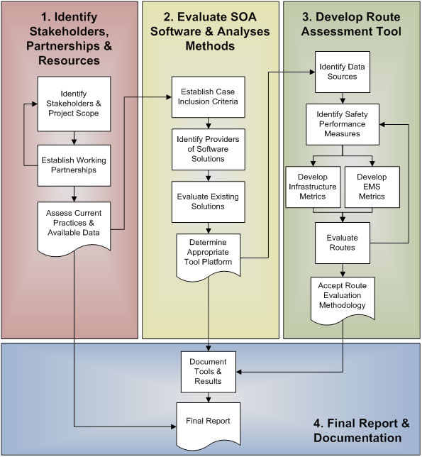
Figure 1. RSAT Task Structure & Workflow
The first task identified key stakeholders and partnerships to support this project. Four states which demonstrated an active interest in motorcoach safety research and possess electronic data on motorcoach carriers, routes and infrastructure for selected areas were identified. These candidate states came to light during preliminary activities related to this project and active relationships were established with either EMS or Transportation agencies in Alabama, Maine, New York, and North Dakota. In addition, separate relationships were also established with the National Association of State EMS Officials (NASEMSO) as well as with a local, independently operated motor coach tour operator. The details of these relationships are outlined in the following sections.
Alabama
Discussions were held with Dennis Blair, the State EMS Director for the State of Alabama and also the then current Chair of the Highway Incident and Transportation Systems (HITS) Committee of NASEMSO regarding the participation of the state of Alabama. Mr. Blair was very helpful in providing a detailed explanation on the logistics behind coordinating the EMS and transportation communities within the state of Alabama. The state also currently has electronic geocoded data for EMS assets, infrastructure, and motor vehicle crashes. Based on these discussions Alabama would provide a good state to test the validity of RSAT and to develop crash response scenarios in the future.
Maine
Jay Bradshaw, the Director of Maine’s Emergency Medical Services, expressed interest in supporting the development of RSAT and suggested that Maine would be a good state to set up a working prototype of MIECE. He indicated that it would also be relatively easy to obtain other information needed to support the tool development since many of the state offices in Maine are close together (many in the same building) and they have good inter-office working relationships. Mr. Bradshaw provided us with Google Earth data files containing the locations of ground ambulance depots with certification level. The Director of the Maine Bureau of Highway Safety, Lauren Stewart, was also briefed on the project.
North Dakota
Mark Nelson, the Director of Safety Division for North Dakota DOT volunteered to provide information about the RSAT project at a meeting with his state EMS director. Subsequent discussions were then held with Tom Nehring, Division of Emergency Medical Services and Trauma, State of North Dakota, who also expressed interest in supporting additional development of the RSAT tool. North Dakota is another state where government is small enough that future collaboration between state EMS and DOT officials would be efficient for the validation ant testing of the tool.
New York
Initial meetings were held with the New York State Division of FHWA in order to evaluate the probability of including NY State in this research and establish additional contacts with NYS DOT and DOH. In attendance at this meeting from the New York Division of FHWA were Maria Chau, Statewide Planner/Research, Christine Thorkildsen, Safety Program Engineer, and Michael Schauer, Senior Transportation Management Engineer. Representing the Federal Motor Carrier Safety Administration, Research Division via telephone was Dr. Martin Walker. As a result of this meeting contacts were made with the NYS Governor’s Traffic Safety Committee (GTSC) to further a data request and partnership. With the support of NYS FHWA, a meeting was arranged with James Allen, the director of NYS GTSC and Chuck DeWeese, the assistant commissioner (who was also with FMCSA for 17 years), to brief them on the RSAT project. They were supportive of the project and provided additional contacts within NYS DOT (Bill Leonard), NYS FMCSA (Brian Temperine), and NYS DOH (Steven Sonder).
A teleconference was also held with Lee Burns, Director of the Bureau of Emergency Medical Services, New York State Department of Health. The purpose of the call was to make a statewide data request for information on EMS agencies. After the teleconference an official request was submitted and received a Freedom of Information Act approval. As a result, a statewide database of ground ambulances with certification levels was obtained for all EMS agencies in NY. The database contained 1,081 records with information on state EMS agencies including addresses but not spatial coordinates. Geocoding methods were employed to successfully place 927 (85.7%) of the locations. The locations and attributes of these EMS agencies were incorporated into RSAT in order to demonstrate the state and local level (Erie County, NY) access to care.
NASEMSO
Dia Gainor, the Executive Director of NASEMSO, provided an overview of the status and the availability of the Model Inventory of Emergency Care Elements (MIECE) project and its applicability to this project. She indicated that MIECE was developed as a ‘proof of concept’ design but that no formal work has yet been initiated to develop the actual software tools to make MIECE a reality. She provided the most current references to MIECE documents and indicated that Alabama appeared to be the state most interested in furthering MIECE development. Discussions were also had on the benefits which would accrue for both the RSAT and MIECE projects if the overall MIECE concept was designed into RSAT. She indicated her strong interest in collaborating with us to further develop a working prototype.
Tour Bus Operator
A meeting was held with John Russ, Vice President of Operations, and Thomas Weeks, Safety Supervisor, of Grand Tours, a local motorcoach operator located in Lockport, NY. The purpose of the meeting was to obtain the perspective of motorcoach operators on issues related to safety, regulations, and technological advances. They provided very meaningful insights into the daily operations of motorcoach carriers including how they conducted their routing, monitoring, training, and maintenance. Of particular interest was a demonstration they gave us on the Saucon Solutions software that they use for vehicle tracking and communications. Overall, they were supportive of the project and expressed interest in a tool that could provide them more informed and safer routing.
A number of software packages related specifically to motorcoach operation, traffic safety analysis, and cross platform development were evaluated for their feasibility of integration and use in this project. The first set of software solutions that were evaluated were developed specifically for use by motorcoach fleets and include Saucon Solutions, Easy Bus Transportation Software, DriveWare, eCoach Motorcoach Software, Travel Manager, Motorcoach Manager, and PowerVue MotorCoach. The traffic safety analysis tools that were evaluated include Highway Safety Manual/Interactive Highway Safety Design Model, SafetyAnalyst, and GIS Safety Analysis Tools v4.0. Finally, a number of independent development platforms were also evaluated to ensure the integration of all aspects of this project. Due to the geographic nature of the data (location of EMS assets, attractions, motorcoach routes) geographic information systems (GIS) such as ESRI’s ArcGIS and Google’s Earth were evaluated.
Motorcoach Specific Software
Saucon Solutions
Saucon Telemetry Delivery System (TDS) provides an integrated suite of web based solutions for multiple uses within the motorcoach field. Some of the features that it provides are GPS vehicle tracking, an electronic on-board (EOBR) system, an electronic driver log module, e-dispatch, and reporting. The GPS vehicle tracking module is a full vehicle monitoring system that has been integrated with Google Earth and also provides a communication link and camera view of the motorcoach in real time. The EBOR system replaces manual driver logs and is compliant with the latest Federal Motor Carrier Safety Administration (FMCSA) regulations. The electronic driver log module provides accurate reporting of driver activity. E-Dispatch is a web-based resource tracking module that provides effective scheduling, mapping, dispatching, and tracking of resources for transportation operations. Finally, the reporting system includes engine analysis, MPG metrics, run time/idle time, asset utilization, asset efficiency, driver performance, and on-time performance.
Easy Bus Transportation Software
Easy Bus Transportation’s EasyTrip Enterprise Software was specifically developed to be easy-to-use for novice computer users at small motorcoach operations or school districts. The customizable software includes tools for trip planning, driver training, vehicle maintenance, scheduling, online trip/charter requests, approval processes, budgeting, driver selection, invoicing, and reporting.
DriveWare
DriveWare Motorcoach System is designed to help small to large size operators and offers tools to help manage group charters and transfers. This software is predominantly focused on providing a management system for reservations, quotes, and invoicing. In addition, it does provide rudimentary route selection on par with typical internet based routing sites.
eCoach Motorcoach Software
eCoach is a complete enterprise management solution specially designed for motorcoach and tour bus operators. eCoach is a web based system that was developed using Microsoft Visual Studio 2005 and Microsoft SQL Server 2005 database. It is modular in design and allows users to select from the following tools: automatic vehicle location (AVL) services & tracking, GPS tracking and mapping, reservation, trip, and routes management. In addition other modules provide quoting, invoicing, and tools for managing statements, contracts, and confirmation letters. Finally, the last set of tools allows for the scheduling of drivers, dispatching of vehicles, and the optimization of vehicle and driver availability.
Travel Manager
Travel Manager offers many features for operating and managing small to large motorcoach fleets. It offers vehicle and driver scheduling, contract management, quote generation and acceptance, fuel monitoring and reporting, tracking of driver and vehicle operating time compliance, and vehicle maintenance and garage management. TravelManager also offers online chartering quotes for customers with real-time availability via an iPhone app. In addition, TravelManager provides flexibility by allowing users to customize their website or web based management system by providing and API to interface with the software. This API allows for integration of online mapping, routing, and timetable generation.
Motorcoach Manager
Motorcoach Managerprovides motorcoach companies with cost-effective software to acquire, manage, store, and report essential business information related to operating private and public motorcoach operations. Additionally, Motorcoach Manager provides accurate and timely reporting to supply regulatory agencies and financial institutions information on company performance.
PowerVue MotorCoach
PowerVue Motorcoach is a complete motorcoach fleet management system. It combines a web-based software, communication options, and on-board computer (OBC) systems. It was designed to meet safety and security requirements issued by the U.S. Department of Homeland Security (DHS) and the Transportation Security Administration (TSA) to qualify for grants from the Intercity Bus Security Grant Program. PowerVue’s advanced safety and security features include GPS monitoring and tracking, remote engine shutdown, and panic buttons for driver and passengers safety. The system also monitors hours of service and driver behavior.
Traffic Safety Analysis Software
Highway Safety Manual/Interactive Highway Safety Design Model
The Highway Safety Manual (HSM) published by AASHTO provides analyses methods to the safety analysis of roadways. The manual was designed for use by planners and engineers at the state, county, local, and metropolitan planning organizations (MPO) levels. The manual is divided into 4 parts. Part A describes the purpose and scope of the HSM, explaining the relationship of the HSM to planning, design, operations, and maintenance activities.
Part B presents suggested steps to monitor and reduce crash frequency and severity on existing roadway networks. It includes methods useful for identifying improvement sites, diagnosis, countermeasure selection, economic appraisal, project prioritization, and effectiveness evaluation. Part C provides a predictive method for estimating expected average crash frequency of a network, facility, or individual site, and it introduces the concept of safety performance functions (SPFs). Part D provides a catalog of crash modification factors (CMFs). CMFs quantify the change in expected average crash frequency as a result of geometric or operational modifications to a site that differs from set base conditions.
The Interactive Highway Safety Design Model (IHSDM) software faithfully implements, to the extent possible, Part C (Predictive Method) of the Highway Safety Manual for evaluating rural 2-lane highways, rural multilane highways and urban/suburban arterials. The IHSDM includes six evaluation modules: Crash Prediction, Policy Review, Design Consistency, Traffic Analysis, Driver/Vehicle and Intersection Review.
SafetyAnalyst
SafetyAnalyst software was built around the criteria specified in the HSM Part B (Safety Management Approaches). The software provides an electronic interactive approach to identify sites for safety improvements, assess safety concerns and select countermeasures, perform cost benefit analyses, and perform before and after studies for implemented safety countermeasures.
GIS Safety Analysis Tools v4.0
The FHWA GIS Safety Analysis Tools are a collection of GIS integrated methods to evaluate motor vehicle crashes. The tools allow for the analysis of intersections, corridors, and clusters. These tools were designed to function within the ESRI ArcGIS platform version 9.1, however there are not compatible with the current version 10.0 or later.
Geographic Information Systems
ESRI’S ArcGIS
ESRI's ArcGIS is a geographic information system for working with maps and geographic information. It is used for creating and using maps, compiling geographic data, analyzing mapped information, and managing geographic information in databases. The system provides an infrastructure for making maps and geographic information available throughout an organization, across a community, and openly on the web. In addition ArcGIS contains many complex methods for accurately geocoding and routing.
Google Earth
Google Earth is a virtual globe, map and geographical information program that was originally called EarthViewer 3D, and was created by Keyhole, Inc, a Central Intelligence Agency (CIA) funded company acquired by Google in 2004. It maps the Earth by draping images obtained from satellite imagery, aerial photography and GIS layers over a 3D globe. The Google version of Earth was released in 2005 and is currently available for use on personal computers running Windows 2000 and above, Mac OS X 10.3.9 and above, Linux 2.6 or later and is also available as a browser plug-in and for mobile viewers using the iOS or android operating systems. Google Earth, while less comprehensive than ArcGIS provides most of the necessary elements required for RSAT, namely geocoding and routing.
The third task was to develop a methodology for identifying and assessing the relative risk of rural motorcoach routes. By examining current motorcoach, traffic analysis, and GIS systems it was apparent that none of the software offered an explicit solution to the tasks outlined in this project. What is apparent however is that several of the motorcoach specific as well as traffic analysis tools are built upon or are already integrated with spatial data. Therefore, it made the most sense to develop RSAT within a GIS platform to provide the greatest efficiency and flexibility. To minimize programmatic risks associated with developing new unproven software, RSAT relies on consumer-of-the-shelf (COTS) software, which minimizes software development time and has demonstrated performance capabilities. Our approach reflects our knowledge of GIS analyses, as well as our experience in local, regional, and national emergency response activities. Based on this experience, our approach provides the following:
RSAT provides both automated and analyst-driven procedures to enable the analyst to view source data, selectively deactivate resources, perform quantitative analyses and visualize response information under a variety of conditions. The modeling environment was built around ESRI ArcGIS 10.2 and Google Earth 7.1 and allows those familiar with GIS programming, to add to or customize the modeling, analysis, and output process. Figure 2 provides an overview of the key components of RSAT.
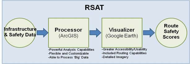
Figure 2. RSAT Key Components
The RSAT processor utilizes ESRI ArcGIS and Spatial Analyst software for the processing of data point layers. ArcGIS provides a powerful and flexible environment for processing large data sets and the ability to produce a number of different output layers based on statistically rigorous quantitative methods. ArcGIS Spatial Analyst is utilized namely to produce raster based distance maps calculated on the input spatial point layers (assets). The general method which is used to create roadway scores is outlined in Figure 3. First a distance is calculated from every asset to the center point of each grid cell overlaid on the entire country. These distances are then classified into a defined set of groups which convey the relative risk associated with being further away from beneficial assets i.e. trauma centers or being closer to harmful assets i.e. previous fatal crashes. Once standardized classes are created for each layer they can be combined and weighted to adjust the significance of any particular layer. The combined weighted layers form a cumulative raster layer with the sum of all individual grid cells. The grid scores are then overlaid on roadway infrastructure data to transfer their values to individual roadway segments and generate a ‘safety’ score.
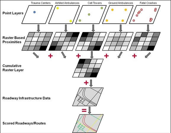
Figure 3. Generalized RSAT Methodology for Scoring Roadways
It should be noted that ArcGIS could be utilized as the entire platform for the RSAT as it also provides visualization and routing capabilities. However, they are not as intuitive for inexperienced GIS users. For this reason ArcGIS is also used to convert native ArcGIS files into Google Earth Files
The RSAT Visualizer utilizes Google Earth software. Google Earth offers a few advantages over ArcGIS because it is more familiar to many end users and requires little prior experience with GIS software (thus reducing the end user’s learning curve). It also enables the end user to readily customize the viewing experience with high quality aerial imagery and wealth of Google supported data layers. Google Earth also allows for the entering or planning of routes via an intuitive built-in interface. Google Earth is available for free from Google and is already widely deployed in state and national departments of transportation. In addition, because many of the motorcoach and traffic safety specific software already in use has integrated capabilities with ArcGIS or Google Earth, it will allow users of that software to quickly learn and utilize RSAT. Furthermore Google Earth Files can easily be stored on a web server and provided to end users for visualization and routing. Due to data sharing restrictions (restrictions for HSIP, ADAMS, and TIEP data is disclosed in the section 4 of this document) however, this capability has not been provided with this delivery.
The data from the state and national partnerships was used in developing RSAT and provides a basis for demonstrating the Capabilities of the tool. Additional EMS asset and infrastructure data was obtained from the National Geospatial Intelligence Agency (NGA) Homeland Infrastructure Foundation Level Database (HIFLD) Gold Edition, the Atlas and Database of Airmedical Services (ADAMS), the National Highway Planning Network (NHPN), and the Trauma Information Exchange Program (TIEP). The data sets of interest including, locations of EMS assets (hospitals, ground ambulances, first responders), highway data, and communications towers and coverage were extracted from these national data sets. The results show a varying degree of quality and completeness across the data sets however these data sets still provide a representative basis for determining what EMS assets are available at the national level.
Each of these data layers has a variety of attributes associated with each geographic location (e.g., ground ambulance data would include depot location, number of vehicles, whether BLS or ALS, number of EMTs/paramedics, etc.) All suggestions and comments from our partners were taken into consideration, including specific attributes users would like to see incorporated, even if data for these attributes are not yet available. A framework has also been provided that allows the analyst to decide how to weight the various safety metrics and how to merge the various factors into an overall safety score. The tool is designed to be flexible and allow refinements to be made as consensus is built on overall combining and scoring methodologies are established.
For this project a “Roadway Safety Assessment Tool” (RSAT) was developed for states to use to identify and evaluate the safety of rural routes that are utilized by motorcoaches. It utilizes inputs from transportation and EMS professionals to measure crash risk along a route, as well as the robustness of communications, EMS response capabilities, and proximity to hospitals and trauma centers. In essence RSAT is a collection of defined methodologies for ingesting, processing, analyzing, and mapping of data for the assessment of roadway safety for motorcoach travel. RSAT is based on a geographic information system (GIS) platform that utilizes ArcGIS for processing data and Google Earth for visualization. A working of knowledge of ArcGIS is necessary to perform additional processing and manipulation of the data while only a basic understanding of Google Earth is necessary to visualize the data.
RSAT is distributed in a single compressed (RSAT.zip) file folder containing the data and files to support processing and visualization of the data. Separate access is required to ArcGIS Desktop Basic Edition 10.2 with Spatial Analyst extension for processing and Google Earth 7.1 is required for visualization. Google Earth can be downloaded free of charge from Google at the following website: http://www.google.com/earth/download/ge/agree.html.
The included RSAT data folder contains a wealth of example layers in point, line, and raster format on various infrastructure and safety data. 'Base Layers' contains background ESRI Shapefiles for Lakes (Lakes_US), Neighboring Countries (neighcountry), Major Roadways (NHPN), Major Roadway Centroids (NHPN_Centroids), Scored Roadways (NHPN_Scored), and State Boundaries (States). 'KMZ Layers' contains Google Earth files in raster format for Air Medical Service Providers (AAMB), Communications (CELL), Aggregated Safety Scores (CUMLATIVE), Fatal Crashes 2007-2011 (FARS), Ground Ambulance Depots (GAMB), and Locations of Level 1, 2, and 3 Trauma Centers (TC).
In addition a vector file is also provided for Scored Roadways (NHPN). 'Point Layers' contains ESRI Shapefiles for Air Medical Service Providers (AirAmbulance), Communications (CellTowers), Fatal Crashes 2007-2011 (FARS_07_11), Ground Ambulance Depots (Ground Ambulance), and Locations of Level 1, 2, and 3 Trauma Centers (TraumaCenters). 'Raster Layers' contains ESRI files in raster format in two folders for UnClassed (raw distance data) and ReClassed (standardized distance data) for Air Medical Service Providers (AAMB), Communications (CELL), Aggregated Safety Scores (EQUALWEIGHT), Fatal Crashes 2007-2011 (FARS), Ground Ambulance Depots (GAMB), Locations of Level 1 Trauma Centers (TC1), Locations of Level 1, and 2 Trauma Centers (TC12), and Locations of Level 1, 2, and 3 Trauma Centers (TC123).
The data sources and distribution limitation are as follows are as follows:
The RSAT processor was designed to be used with ArcGIS 10.2. After this software has been installed the RSAT Processor application can be opened to create, manage, and process infrastructure and safety data. Figure 4 provides an image of the RSAT processor displaying the included point layers. Additional information on the RSAT Processor can be found in the RSAT User's Manual.
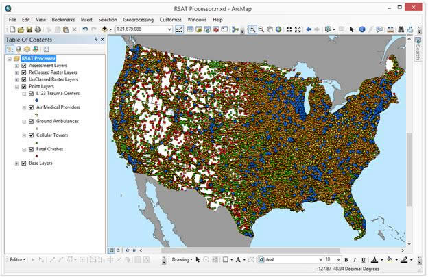
Figure 4. RSAT Processor
The RSAT processor allows users to selectively browse the different data sets previously discussed as well as process and implement new data layers. Any data set that is considered relevant to the assessment of safe motor coach travel can be imported as an ESRI point shapefile. In addition to included data, the following methodologies are provided to create additional safety layers and assessments:
Utilizing the above mentioned processes the end user can generate new roadway safety scores for any size geographic area from the local level to the state level, on up to the national level which is provided in the example data. With the processing of the data layers complete end users can utilize the RSAT Visualizer to explore the data as described in the next section.
Google Earth was utilized as the RSAT Visualizer in order to provide a widely available free platform to view the scored safety layers created in the RSAT Processor. Google Earth is a basic GIS platform that allows for the exploration and visualization of spatial data layers and also some basic analytical tools. The basis for Google Earth is a three dimensional model of Earth that allows the user to drape additional layers over terrain models and relatively high resolution orthoimagery.
After downloading and installing Google Earth 7.1 and upon using the RSAT data for the first time each KMZ data layer will need to be opened in Google Earth and moved to the 'My Places' section for viewing at a later date. Google Earth will drape the image over the background globe. In order to preserve the images and load upon the opening of Google Earth the layers can be moved to 'My Places'. Figure 5 provides and image of the RSAT Visualizer displaying scored roadways overlaid on the cumulative raster data layer.
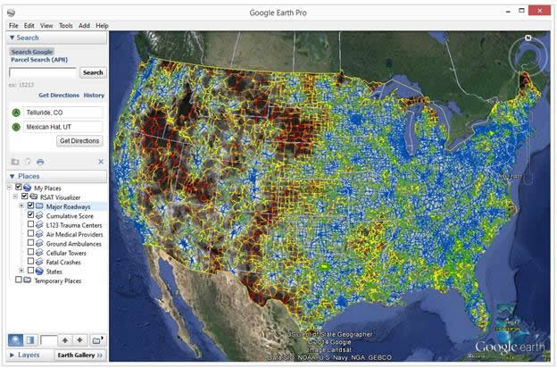
Figure 5. RSAT Visualizer
In the Case of the Mexican Hat motorcoach crash, which was the impetus for this project, the RSAT Visualizer clearly shows that the route used by the motorcoach (Figure 6) had a high relative risk (using baseline data and assuming equal weighting of all assets). The original route was scheduled to depart Telluride, CO and end in Phoenix, AZ. Due to adverse weather conditions however the route deviated from Colorado State route 145 and instead traversed U.S. Route 163/191 through Utah. While both routes presented significant risks due to increased distances to EMS resources, U.S. Route 163 offered increased risks, especially due to a lack of cellular coverage at the time of the crash in 2008. Route planning via the RSAT Visualizer could have clearly quantified those risks had the tool been available to the motorcoach company at the time.
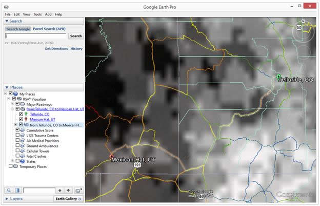
Figure 6. Route Used in Mexican Hat Motorcoach Crash
The RSAT Visualizer was designed to be very flexible and provide wide access to safety data to a wide range of end users from traffic safety engineers, EMS agencies, motorcoach company route planners, to the public at large. Utilizing the data provided with RSAT, or user supplied data, users now have a choice when planning trips to not only select the quickest or shortest route, but instead to select the ‘safest’ route by minimizing risk as expressed by shorter distances to available EMS assets in the event of a crash.
The final task of this project included fully documenting the tools that were developed and providing the prototype tool to FHWA. This resulted in the ArcGIS/Google Earth based RSAT tool with a user’s manual and supporting data layers for demonstration. This final report provides the key lessons learned from creating the state partnerships, identification and status of sources of data, and future visions for the further development of RSAT. This research project provides a number of operational interests for stakeholders in federal, state, and local agencies. These agencies have great need for improved tools, techniques, information, and understanding in order to be able to prevent, prepare for, respond to, and recover from mass casualty motorcoach crashes. These agencies include:
RSAT is a collection of defined methodologies which are housed in a GIS platform that allows for powerful and flexible analysis of numerous infrastructure and EMS safety layers. Based on the quality of the input data and weighting schemes the resulting visualizations can provide a very effective way to communicate the relative risks associated with motorcoach travel throughout the U.S. The end result provides route planners with the ability to prioritize routes not only shortest distances or time but also by relative safety.
RSAT provides a robust analytical method t determine the risk associated with travel in rural areas relative access to care throughout the U.S. The output and analysis of these methods are limited however by the availability and quality of input the input data. The currently included data sets with RSAT are national available data (geographic location and selected attributes) for air medical services (ADAMS-AAMS/CUBRC), trauma centers (TIEP, ATS/ UPENN), cell tower locations (HSIP – NGA no attribute information and some tower locations clearly missing e.g. Dallas, TX, Albany, NY), ground ambulance depots (HSIP – NGA attributes on the number of ambulances, service level ALS/BLS, and staffing levels missing for a majority of records), and geocoded fatal crash data for nation (FARS, NHTSA-USDOT but not geocoded injury crash data). Alternative sources of similar data, often of better quality, are available through state agencies and without data sharing restrictions. In this case sources of state data should be incorporated in lieu of national data via the methods provided in the RSAT user’s manual.
This research resulted in advanced tools to help plan and evaluate the safety of motorcoach routes. Although this tool focuses on motorcoach route safety, it could easily be expanded to support analysis of a broad range of route safety and emergency response issues for the public at large. As a result, it is reasonable to assume that advanced systems to plan and evaluate emergency response operations will result in reduced mortality and morbidity from emergency events, reduced congestion due to more rapid resolution of the event, and more efficient use of emergency response assets.
The Model Inventory of Emergency Care Elements (MIECE) was proposed as a tool to measure an EMS system’s capability to respond to mass casualty incidents within a given geographic area This proposed model inventory includes asset locations and measurable attributes or characteristics of emergency care system (e.g. level of service ALS/BLS, the number of available paramedics, the number of available of airmedical helicopters, whether blood is carried, certification level of area trauma centers).The intent in extend RSAT to incorporate all of these attributes is to create a dynamic real-time “dashboard” where EMS or highway officials, motor coach route planners, or the public could view a regularly updated highway map showing the availability of emergency medical and hospital care in an area or the potential risk of travelling through any area in the event of a emergency event. In order to accomplish this RSAT would require obtaining additional attribute data on EMS resources and the development of a user interface to support queries e.g. the number of assets available within 30 min, 60 min, etc.
Under MAP 21, a performance-based, Federal system is being established by states to set targets for total number of injuries and fatalities (per VMT). In order to accomplish this, the capabilities of states to collect safety data collection, analysis, and integration will need to be advanced according to the state Strategic Highway Safety Plans (SHSP). Safety data systems to support problem identification and countermeasure analyses will include the following:
A modified version of RSAT could add another factor (Access to Emergency Care) to support advanced risk assessment and help to further prioritize roadway safety improvements.
As provided RSAT is focused on the emergency response to mass casualty motorcoach crash however a modified tool could easily be used to assess safety of a route with respect to crashes of different kinds of vehicles, such as truck crashes or motorcycle crashes, or to assess safety of route for different types of crashes such as single vehicle run-off-the-road or head-on collisions
Additionally, RSAT was initially envisioned to aid in the prevention and mitigation and preparedness phases of emergency incident management (Figure 7).
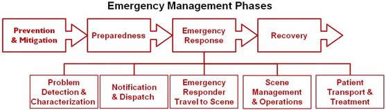
Figure 7. Phases of Emergency Management
With additional work RSAT could be extended to the ‘Emergency response and recovery phases to identify and locate, in real time, available EMS resources able to respond to emergencies. This capability could then be used to detect developing gaps in access to care as assets become utilized and prioritize a recovery strategy. These techniques could then also be used to identify risks associated/correlated with different types of emergencies and to identify infrastructure and EMS resource improvements correlated with types of emergencies.

