U.S. Department of Transportation
Federal Highway Administration
1200 New Jersey Avenue, SE
Washington, DC 20590
202-366-4000
FHWA-SA-11-38
According to the National Highway Traffic Safety Administration, the number of people who died in crashes across the country decreased from 37,423 in 2008 to 33,808 in 2009. In addition, the number of people injured declined for the ninth year in a row to just over 2.2 million. Even in light of these reductions, motor vehicle crashes remain a significant problem. These traffic crashes cost the Nation over $230 billion each year. To improve safety, a coordinated response is needed from all levels and branches of government – Federal agencies, State legislatures, city and county councils, and local agencies. A coordinated response should result in increased safety funding, more effective safety laws, and enhanced education, enforcement, engineering, and emergency response efforts targeting critical safety issues. As part of the overall strategy to reduce fatalities and serious injuries, California has an approved Strategic Highway Safety Plan (SHSP), which identifies the following challenge areas: impaired driving, leaving the roadway and head-on collisions, driver licensing and competency, safety belts/child safety seats, driver decisions about rights of way/turning, young drivers, intersections/interchanges, walking/street crossing, older roadway users, speeding/aggressive driving, commercial vehicles, motorcycles, bicycling, work zones, post crash survivability, data collection/access/analysis, and distracted driving. To obtain a copy of the SHSP, contact the State DOT or FHWA Division Office Safety Specialist.
| Indicators | CA | U.S. |
|---|---|---|
| Total Fatalities | ||
| 2009 | 3,081 | 33,808 |
| Average: 2000-2009 | 3,922 | 41,157 |
| Fatality Rate (per 100M VMT) | ||
| 2009 | 0.95 | 1.14 |
| Average: 2000-2009 | 1.21 | 1.41 |
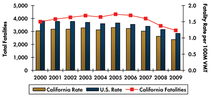
Fatality rate is calculated based on State fatalities per 100 million vehicle miles traveled (VMT). Total fatalities are taken from the Fatality Analysis Reporting System (FARS).
Source: Fatality Analysis Reporting System (FARS) 2000-2008 Final & 2009 Annual Report File (ARF).
This chart represents national safety focus areas and their corresponding percentages of total crash fatalities in the State and in the Nation. More than one of these focus areas may be involved as contributing factors in a single crash.
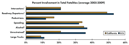
In the graphic, "Intersections" refers to non-interchange intersection/intersection-related crashes; "Roadway Departures" refers to non-intersection crashes in which a vehicle crosses an edge line, a centerline, or leaves the traveled way (includes intersections at interchange areas); "Alcohol" refers to crashes involving a driver with a blood alcohol content (BAC) =.01+; "Unrestrained" refers to unrestrained passenger vehicles occupant fatalities (does not include unknown restraint use).
Source: Fatality Analysis Reporting System (FARS) 2000-2008 Final & 2009 Annual Report File (ARF).
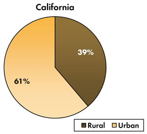
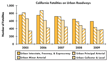
Source: Fatality Analysis Reporting System (FARS) 2000-2008 Final & 2009 Annual Report File (ARF).
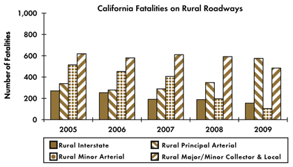
Source: Fatality Analysis Reporting System (FARS) 2000-2008 Final & 2009 Annual Report File (ARF).
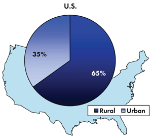
For the purposes of this document, the terms urban and rural are based on the definition published in the American National Standard (ANSI D16.1-1996).
The Transportation Safety Planning Working Group
Fatality Analysis Reporting System
National Highway Traffic Safety Administration
Federal Highway Administration Division Office Contacts
Federal Highway Administration, Office of Planning
Federal Highway Administration, Office of Safety
Federal Highway Administration Resource Center
Contacts Planning Team Leader
FHWA, California Division
650 Capitol Mall, Suite 4-100
Sacramento, CA 95814
(916) 498-5001
Jennifer Warren
Transportation Specialist
FHWA, Office of Safety, E71-113
1200 New Jersey Ave, SE
Washington, DC 20590
(202) 366-2157
Fax (202) 366-3222
Jennifer.Warren@dot.gov
Rae Keasler
Transportation Planner
FHWA, Office of Planning, E72-109
1200 New Jersey Ave, SE
Washington, DC 20590
(202) 366-0329
Fax (202) 493-2198
Rae.Keasler@dot.gov
Safety and Design or Planning Team
FHWA Resource Center
One Prairie Office Center
4749 Lincoln Mall Drive, Suite 600
Matteson, IL 60443
Phone: (708) 283-3500
Fax: (708) 283-3501

