U.S. Department of Transportation
Federal Highway Administration
1200 New Jersey Avenue, SE
Washington, DC 20590
202-366-4000
The Town of Eagle, Colorado recently prepared an Environmental Assessment (EA) for the future East Eagle Interchange project. The purpose of the EA was to identify transportation projects that improved roadway connectivity in the East Eagle area and accommodated anticipated growth and development. Four primary needs were expected to be met by these improvements, but specific to safety, the identified needs were to:
The Preferred Alternative was chosen, in part, because it met the need to improve the operational and safety aspects of the transportation network.
There can be many competing interests and priorities during the development of a transportation project, but to equally consider all of the needs of a project (mobility, safety, and connectivity), the Town of Eagle followed a data-driven and innovative process for selecting their Preferred Alternative.
This evaluation was performed using congestion, safety, and environmental data. For the safety element, crash data was taken from a safety study completed by the Colorado DOT in 2008. The data specifically looked at the trends in crash rates along I-70 from 2000 to 2004 and used it as a baseline to demonstrate that safety problems would persist and crashes would increase if no action was taken to improve the roadways in the study area. This study also included an innovative approach to determine the future safety performance of the project alternatives. Specifically, they developed a safety performance function to estimate crash rates for out-years and to inform the selection of countermeasures. Safety performance functions describe the relationship between traffic exposure (Average Daily Traffic (ADT)) and crash frequency (crashes per mile per year).
Once the Town had a complete understanding of transportation issues and needs, they formed a Project Working Group (PWG) consisting of representatives from the FHWA, Colorado DOT, the Town of Eagle, and Eagle County, along with engineering and environmental consultants. The PWG created a step-by-step process to identify, develop, and evaluate all of the alternatives, and eventually select the alternative that met all of the defined needs. Throughout this five-step process, safety elements played a prominent role in the goal setting, evaluation, and eventual selection of the Preferred Alternative. The steps were as follows:
During the first step, each potential alternative had to meet five specific goals to advance to the next stage. Two of the five goals were specific to safety.
Each alternative that fit within the above goals was then rated based on five evaluation criteria – its impact on safety, mobility, environment, community, and implementation. To effectively measure the safety benefits in each alternative, a specific set of criteria was used. This included:
If the alternative met the projected goals and was positively evaluated, it was then summarized based on its advantages and disadvantages. Figure B.1 depicts the initial screening process for one of the alternatives. This process was completed for all of the alternatives until a Preferred Alternative was chosen.
Figure B.1 Alternatives Analysis Summary Sheets
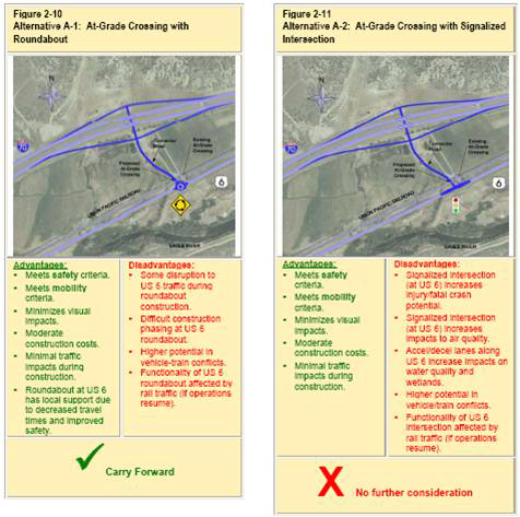
Source: East Eagle Interchange Environmental Assessment, August 2010.
By using a well-defined process with specific goals, data, and methods, the Town of Eagle was able to establish a Preferred Alternative that met the critical safety, mobility, and community needs established at the beginning of the project.
The project area contains the Stapleton Redevelopment Area, a 4,700-acre mixed-use development area located in eastern Denver, Colorado. The site is projected to accommodate 30,000 residents and provide employment for 35,000 workers. The current accessibility options to/from Stapleton are congested and expected to worsen as more development occurs.
To address these issues, a new six-lane bridge and highway interchange was proposed to be constructed. The I-70/Central Park Boulevard (CPB) Interchange will provide direct access between the Stapleton Redevelopment Area and major interstates I-70 and I-270; will connect the north and south sides of the Stapleton redevelopment; and will provide safe access for automobiles, pedestrians, and bicyclists.
The I-70/CPB Interchange project was an element of the I-70 East Draft Environmental Impact Statement (DEIS), which covered transportation improvements along a large stretch of the I-70 highway corridor, from I-25 to Tower Road. However, with the availability of new funds, the City and County of Denver (CCD) and the FHWA decided to advance the CPB Interchange project independently, triggering its own NEPA process. The resulting Environmental Assessment (EA) carries forward the crash data (1999 to 2001) from the original DEIS, which was used as a baseline to portray the existing safety issues along the entirety of I-70 East and make projections about future issues in the study area. This data is included in the EA primarily to set the context for safety concerns in the study area, but not as part of the purpose-and-need statement, which does not explicitly reference safety:
The purpose of the identified project is to provide improved connectivity to I-70 that supports local and regional access to/from existing and planned land uses served by CPB north and south of I-70. The project is needed due to the development of Stapleton and the projected levels of congestion in the area.
The Preferred Alternative for this project was chosen because it exemplified the specific elements of the purpose-and-need statement. It also reflects input obtained from nearby neighborhoods, businesses, local jurisdictions, and stakeholders. However, the concept for analyzing and utilizing safety data, which was used for the DEIS, is innovative and worthy of replication in other states.
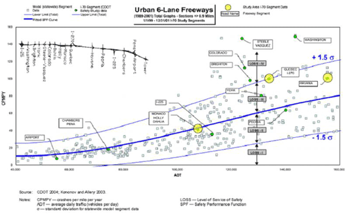
For the original DEIS, the Colorado DOT used a Level of Service of Safety (LOSS) approach to compare traffic safety under existing conditions with safety conditions for future design alternatives. The magnitude of safety problems on highway segments was then evaluated using safety performance functions. A Safety Performance Function (SPF) is a probability function describing the relationship between traffic exposure (Average Daily Traffic (ADT)) and crash frequency (crashes per mile per year). The SPF defines the normal or expected number of crashes at a specific ADT. The degree of deviation from the expected performance is classified as LOSS I to IV.
The LOSS uses qualitative measures to characterize the actual safety performance of a road segment to the expected safety performance. It is assessed for total crashes and injury/fatal crashes separately.
The two road segments on I-70 within the CPB area experienced an LOSS of IV and an LOSS of III for total crashes, and an LOSS III for injuries and fatal crashes. Figure B.2 depicts the Colorado DOT LOSS model for total crashes on six-lane freeways. The overall intent of the LOSS analysis was to identify the need for safety improvements, and to inform the selection of appropriate countermeasures to remedy the issues. Colorado DOT also analyzed crash concentrations and patterns on road segments and interchanges to identify any safety problems within the study area. This included analysis of crash type, severity, direction of travel, road conditions, spatial distribution, and time-of-day travel patterns. The EA cites this analysis to support an assertion that these road segments and interchanges were in need of potential improvement, but does not suggest specific countermeasures or design ideas to remedy the issues.
The Preferred Alternative was chosen based on engineering, environmental, and other criteria. The “other” criteria included consistency with other planning documents and the ability to provide multimodal access. Although safety was not specifically noted as being part of the selection criteria for the multimodal elements of the project, the direct access between the north and south side of I-70 will provide an enhanced environment for pedestrians and bicyclists as a result of including the following improvements:
Figure B.2 Colorado DOT LOSS Model for Total Crashes in Study Area
The purpose of the SR 502 corridor-widening project is to improve mobility and safety along the SR 502 corridor between NE 15th Avenue and NE 102nd in North Clark County, Washington, where collision and congestion rates have been increasing. Safety concerns in the project area included:
Since one of the two primary objectives of this project was to improve safety in the corridor, alternatives were evaluated based on how well they met the purpose-and-need, specifically looking at the number of locations – either at driveways or intersections – where traffic patterns crossed and created potential conflict points.
The EIS began with a total of nine alternatives:
Two on-corridor alternatives, the off-corridor alternatives and the TSM/TDM alternatives, were eliminated early as they did not meet the mobility and safety needs of the project. Of the three remaining on-corridor alternatives, Washington DOT created a hybrid that minimized the environmental effects and satisfied the project’s purpose-and-need for safety and mobility. The hybrid, or the Pink Alternative, became the Preferred Alternative studied in the Final Environmental Impact Statement (FEIS). The cross-section for the Preferred Build Alternative is shown in the below diagram. In 2010, the FHWA signed the Record of Decision (ROD) for the SR 502 corridor-widening project, concurring with Washington DOT on the Preferred Alternative.
Figure B.3 Build – No-Build Alternative
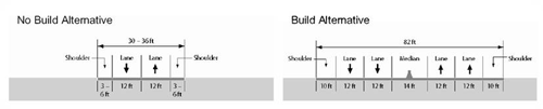
Under current or No-build conditions, the collision rates in this corridor already exceed the statewide average and are projected to increase with traffic volumes. The Preferred Alternative presents a number of safety measures to reduce injury and fatality rates.
As shown in the cross-section diagram, the Preferred Alternative has a 14-foot median, running the length of the corridor. As noted in the EIS, this roadway design feature is a proven safety treatment, as it greatly reduces head-on crashes and restricts left-hand turning movements and u turns, unless at signalized intersections and in protected turn lanes. In some instances, center turn lanes are viable alternatives to center medians. However, they were not considered here because they are designed for managed access, low speed urban roadways with traffic volumes under 24,000 per day. SR 502 is projected to be four-lanes with 42,000 vehicles per day, which would make it hard for cars to find appropriate gaps in traffic to make left turns from a center lane. Cars turning left from driveways or unsignalized intersections also would need to cross multiple lanes of traffic, making the center-lane option unsafe.
Access control was an additional consideration. There are approximately 150 driveway access points onto SR 502, but only one signalized intersection in the corridor that provides cars with a safe opportunity to turn left. Outside this intersection, drivers can currently make left-hand turns to and from driveways, and across oncoming traffic onto SR 502, wherever they choose. To provide the left-turn option, but in a more managed way, driveway connections onto SR 502 would be consolidated and three intersections were assessed to see if traffic conditions, pedestrian characteristics, and physical characteristics of the locations would warrant a traffic signal. In the Preferred Alternative, four intersections would be signalized, eliminating other conflicting movements, which generally require quick reaction time and judgment. These additions, plus the new median, will mean that access onto and across the project corridor will be controlled, and will reduce crashes.
The number of travel lanes on SR 502 will be increased from one to two in both directions, which would provide a safer means to pass slow-moving vehicles. The additional capacity on SR 502 also is projected to ease current and projected congestion issues. Analysis suggested that additional capacity would encourage people that currently utilize alternate routes to avoid SR 502 traffic to use the safer, more direct route that the project will provide.
The Preferred Alternative also calls for 10-footwide shoulders that will provide a safe area for broken down cars, as well as safe bicycle mobility. The four intersections also will have crossing treatments allowing pedestrians to access both sides of SR 502.
The Preferred Alternative meets the purpose-and-need of this project by specifically addressing all of the safety concerns (as well as mobility concerns) for this corridor.
The roots of this Draft Environmental Impact Statement (DEIS) began in 2000, when the Mayor of Washington, D.C. brought together Federal and District agencies to guide development along the Anacostia River waterfront. From these initial meetings, the District DOT Office of Planning created the Anacostia Waterfront Initiative Framework Plan, which examined the potential for development on and near the waterfront. The Plan also addressed South Capitol Street, which was identified as a potential civic gateway to the central part of the city by providing a mix of shopping, housing, and offices. Encouraging the development of South Capitol Street would serve as a catalyst for the development of the Anacostia Waterfront. This idea started the process for a series of plans and studies to investigate and analyze existing and future transportation patterns in the South Capitol corridor. As it stands today, the stated purpose of the South Capitol Street project in the DEIS is to improve safety, multimodal mobility, and accessibility; and support economic development.
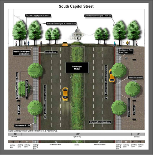
Historic city planning documents call for South Capitol Street to serve as a gateway into Washington, D.C. Yet today, the corridor functions mainly as an expressway, lacking any characteristics of its historic or gateway functions. By transforming South Capitol Street from an expressway to an urban boulevard, the project would improve multimodal mobility, safety, accessibility, and economic development. In particular, a streetscape concept would improve the safety of the pedestrian and cycling environment by adding widened sidewalks; widened curbside lanes on some streets for bicycle travel; and increased pedestrian- and bicycle-oriented elements, such as street trees, benches, and decorative streetlights. The current streetscape concept for South Capitol Street, found in the DEIS, is shown in Figure B.4.
Figure B.4 Streetscape Concept for South Capitol Street
Crash data from January 1, 2000 until December 31, 2004 shows that some of the highest fatality rates in the District occur at four major intersections within the corridor. Crash severity rates at intersections in the corridor were calculated using the equation shown in the box at right. Rear-end crashes are the most frequent type of crashes, followed by left-turn and sideswiped crashes.
Factors contributing to these unsafe conditions include:
To address these issues, the DEIS evaluates two build alternatives (1 and 2) and a No-build alternative. The No-build would not adequately address the safety issues because it would include only small and isolated safety improvements. These would reduce left-turn and some rear-end crashes, but would not be sufficient to address additional crashes expected as traffic volumes increase.
Both Build Alternatives 1 and 2 include redesigned intersections with additional turn lanes and reconfigured interchanges intended to improve traffic flow and reduce the likelihood of crashes among motorists. Pedestrian and bicycle safety improvements would include new crosswalks, pedestrian signals, curb cuts, refuge islands, and other bicycle accommodations. Alternatives 1 and 2 also would replace the Frederick Douglass Memorial Bridge with one that meets current design standards and provides a safer crossing for pedestrian and bicyclists. The primary difference between the two alternatives is that Build Alternative 2 increases the number of at-grade intersections and traffic circles/ovals, which could create conflicting movements between automobiles. Build Alternative 1 proposes to keep median barriers and maintain grade separations, reducing the potential for conflicts.
The Preferred Alternative will eventually be chosen and further examined in the FEIS. The proposed urban boulevard design for South Capitol Street will contribute to the safety, accessibility, multimodal mobility, and economic development of the corridor.
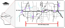
A 40-mile stretch of U.S. 8 runs east to west in Wisconsin from WIS 35 North in Polk County to U.S. 53 in Barron County. This corridor passes through the Communities of Range and Poskin; the Villages of Turtle Lake and Almena; the City of Barron; and the Towns of St. Croix Falls, Balsam Lake, Apple River, Beaver, Almena, Clinton, Barron, and Stanley. Since the mid-1990s, the corridor has been of interest to a group of county and local officials, concerned with safety and congestion along the corridor. Known today as the U.S. 8 Coalition, the group has expanded and consists of county highway commissioners, highway committee chairpersons, and community members from each county. The group’s goal is to promote, develop, and prioritize improvements to U.S. 8. In 2001, the original legislative mandate to study this stretch of the corridor was the direct result of input from the Coalition.
The purpose of this project was to identify the preferred corridor for the eventual construction of a multilane facility meeting future transportation and safety needs for U.S. 8. Because of the length of the corridor and the complexity of issues in each community, analysts divided the corridor into seven individual segments for study. Each segment had one or more alternatives in addition to the No-build alternative. Of the seven segments, the Turtle Lake segment is the only one without a Preferred Alternative. Due to the number of severe crashes in the Village of Turtle Lake, analysts concluded further study in the form of a Tier 2 EIS or EA was needed.
The project Tier 1 EIS, including an ROD, has been completed, resulting in consensus on the basic location and design vision for the overall corridor. The Tier 2 environmental documentation will include formal corridor preservation for the preferred segments, and Tier 3 will include advancement of the proposed alternatives to projects that move to final design.
Due to the interest and commitment of the U.S. 8 Coalition, public support has been high for improvements that address congestion, safe access to and from U.S. 8, and mobility for both local and regional traffic. In 1994, the Coalition developed purpose and mission statements to formalize its desire to provide a safe route that met the growing demands of the collective communities. The purpose of the group is to secure the provision of safe and efficient travel and economic growth on U.S. 8 for the next generation; and the mission is to work cooperatively in promoting, developing, and prioritizing improvements to U.S. 8 from the Minnesota/Wisconsin border to WIS 13 in Price County. From the beginning, the Coalition established a close working relationship with the Wisconsin DOT, who ultimately helped them secure money from the State Legislature to study the safety and congestion impacts along this 40-mile stretch of U.S. 8. As part of the EIS environmental process, the Coalition participated in public forums, held their own meetings to update members regarding the progress and issues along the project, and made a commitment to long-range planning activities in their local Comprehensive Plans.
Another element of this project indicative of the Coalition members’ commitment to safety in the corridor was the response to the road safety analysis. Updated crash analysis, covering 2001 to 2006, showed the crash rates throughout the corridor, as a whole, were below the statewide average, but fatal crash rates exceeded the statewide average on more than one-half of the individual segments. In particular, the recent number of fatal crashes in the Village of Turtle Lake prompted the Village to ask for a Road Safety Audit from Wisconsin DOT. This delayed the recommendation of a Preferred Alternative in the Tier 1 EIS for the Village of Turtle Lake, but the results of the road safety audit will be used to inform the Tier 2 environmental documentation. Tier 2 will specifically evaluate and select a Preferred Alternative for the Turtle Lake segment that meets the safety needs of the project.
The Tennessee DOT has an extensive program to conduct Road Safety Audit Reviews (RSAR) that examine the need for safety improvements for existing road segments, intersections, corridors, and ramp queues. The intent of the RSAR program is to implement low-cost safety improvements in an expedited manner.
The RSAR process involves a multidisciplinary team, including staff from the Short-Range Planning Office, the Project Safety Office, the Conceptual and Environmental Documentation Office, the State Bike/Pedestrian Coordinator, Region Design Office, and the Region Traffic Office. Additional professionals (e.g., law enforcement, structural, or right-of-way) participate as needed. The RSAR team examines the interaction of project elements and considers the safety of all road users while promoting Tennessee DOT’s goal of reducing injuries and fatalities.
Tennessee DOT’s Project Safety Office manages the RSAR process. They initiate the RSAR and perform the following duties:
Environmental staff are invited to prebriefings and to discuss safety issues identified during the RSAR, as well as to recommend improvements. At the prebrief meeting, participants plan a site visit and review data, including collision history, collision diagram, traffic volumes, and aerial photos. The multidisciplinary team conducts the site visit and considers all factors that could impact safety, such as all road users, environmental conditions, safety, road user characteristics, and surrounding land uses.
The RSAR focuses almost entirely on safety improvements, and does not consider operational issues in detail. If an operational or design issue did arise during the audit, the project would be handled in more traditional manner with coordination between the planning and NEPA staff. Under typical conditions, the RSAR safety recommendations qualify for treatment as a Categorical Exclusion (CE), allowing expedited execution. These types of activities include, but are not limited to, pavement markings, rumble strips, traffic lights and/or signs, guard rails, and concrete barrier end treatments.
Tennessee DOT has prepared a Programmatic Categorical Exclusion (PCE) for most of these types of projects, presuming that they stay within existing right-of-way. The PCE includes technical studies: historical, archaeological, air and noise, hazardous materials, and ecological reports that are subject to the FHWA oversight and approval. In this manner, Tennessee DOT is able to expeditiously address safety problems as soon as they are evident.

