U.S. Department of Transportation
Federal Highway Administration
1200 New Jersey Avenue, SE
Washington, DC 20590
202-366-4000
NOTEWORTHY PRACTICE
FHWA-SA-19-017
Best for printing: [PDF] (755 KB)
To view PDF files, you can use the Acrobat® Reader®.
The East-West Gateway (EWG) Council of Governments (COG) has set performance targets to reduce the number of non-motorized fatalities and serious injuries and actively works to meet the targets.
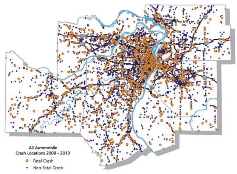
Fatal and Non-fatal Crashes in the St. Louis Region
(Source: https://www.ewgateway.org/transportation-planning/bicycle-pedestrian/)
EWG is the St. Louis region’s federally designated metropolitan planning organization, covering counties and municipalities in Missouri and Illinois. The Federal Highway Administration (FHWA) Safety Office has designated St. Louis as a Bicycle/Pedestrian Safety Focus City, which provides St. Louis with additional opportunities for technical assistance from FHWA. This designation is reserved for cities with high numbers of bicycle and pedestrian fatalities. St. Louis had one of the highest numbers of bicycle and pedestrian fatalities in the nation based on a three-year average from 2011 to 2013.
For 2018, EWG established a target of reducing the number of non-motorized fatalities by 2 percent for the metropolitan planning area, or a combined total of no more than 205.3 serious injuries and fatalities in non-motorized crashes.1 The agency actively performs multiple initiatives to help meet the performance targets, with an emphasis on data-driven decision making.
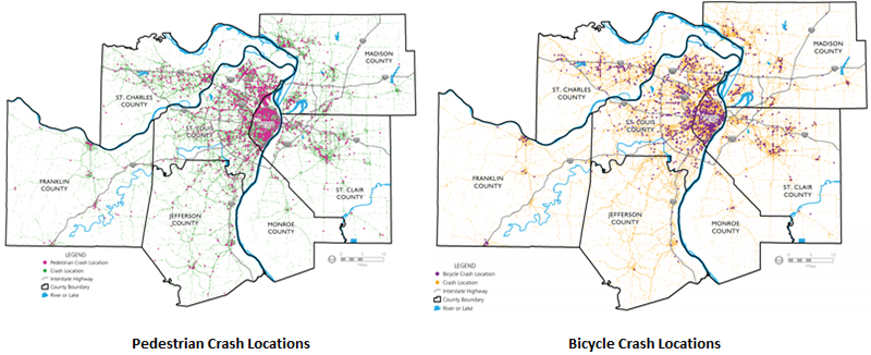
Pedestrian-Bicycle Crash Locations.
(Source: https://www.ewgateway.org/transportation-planning/bicycle-pedestrian/)
To help achieve its targets, the EWG has initiated several initiatives to promote data-driven decision making, which is the basis for any performance-based safety program.
In 2018, EWG published two documents—2018 Bicycle Crash Analysis1 and 2018 Pedestrian Crash Analysis2—which reviewed all reported crashes in the EWG region that involved a bicycle or a pedestrian.

The analyses included maps of the region, charts, graphs, strategies to prevent these crashes, and outside resources for local public agencies in the St. Louis metropolitan area. EWG designed the documents to encourage local partners to identify appropriate safety projects that could be eligible for federal funding through EWG or other sources. To help partners develop successful safety-related bicycle projects, EWG also released its Bicycle Planning Guide in 2018.
To develop data-driven decision making, EWG initiated the 2017 Bicycling and Walking Survey. Participants completed 883 surveys, with the survey results offering insight on the level of comfort of the users, motivational factors of walking/biking, and public sentiment about improvements to bicycling and walking facilities.
EWG maintains an inventory of existing on-street and off-street bicycle facilities in the St. Louis region. Engineers can use this inventory to evaluate the safety effects of bicycle facilities.
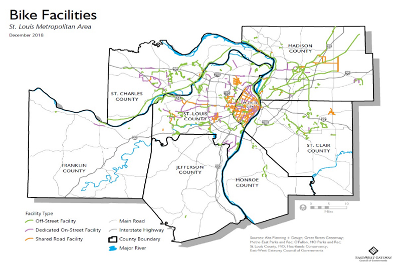
Bicycle Facilities.
(Source: https://www.ewgateway.org/transportation-planning/bicycle-pedestrian/)
The data from the above sources is used to inform safety practitioners and stakeholders at various workshops in the region, which are designed to improve bicycle and pedestrian safety programs. EWG has hosted and will continue to organize bicycle and pedestrian planning workshops, including a National Association of City Transportation Officials Bicycle Planning Workshop, Safe Transportation for Every Pedestrian Workshop, and Bikeable and Walkable Communities Workshop.
Peter Koeppel, Long-Range Transportation Planning Coordinator, EWG Council of Governments, peter.koeppel@ewgateway.org, (618) 274-2750.
1 East-West Gateway Council of Governments. 2018 Bicycle Crash Analysis. https://www.ewgateway.org/wp-content/uploads/2018/07/BicycleCrashAnalysis-2018.pdf.
2 East-West Gateway Council of Governments. 2018 Pedestrian Crash Analysis. https://www.ewgateway.org/wp-content/uploads/2018/07/PedestrianCrashAnalysis-2018.pdf.
s/default.aspx.
