U.S. Department of Transportation
Federal Highway Administration
1200 New Jersey Avenue, SE
Washington, DC 20590
202-366-4000
![]()
| < Previous | Table of Content |
| Project: replacement of existing interchange with new access | |||
|---|---|---|---|
| Planned Improvements: |
|
||
| Project Environment: | urban | suburban | x rural |
| Project Design Stage: | x conceptual (0 to 30%) | preliminary (40 to 80%) | advanced (over 80%) |
| Project Cost: | < $100,000 | $100,000 - $1,000,000 | x >$1,000,000 |
| Project Owner: | National Park Service | ||
| Road Safety Audit | |||
| Date of RSA: | 31 May to 2 June 2005 | ||
| RSA Stage(s): | x design stage | x RSA of existing roads | |
| RSA team: | staff from Federal Highway Administration Resource Center, Federal Highway Administration Federal Lands, and Opus Hamilton | ||
PROJECT BACKGROUND:
Yellowstone National Park, the world’s first national park and a designated World Heritage Site, accommodates about 3 million visitors every year. The Old Faithful area (FIGURES A.14 and A.15) is a popular destination within the Park, attracting about 85 percent of all Park visitors. Peak visitor months are July and August, when the Old Faithful road network accommodates an average daily traffic volume of about 6,000 vehicles.
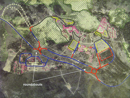
At the time of the RSA, two planning-level concepts (FIGURE A.16) had been developed to replace the existing Old Faithful interchange, which provided the only public access to Old Faithful Road from the Grand Loop Road:
These two concepts were reviewed as part of the RSA. At the time of the RSA, these and other alternative concepts were still under development, and were subject to substantial changes pending completion of resource surveys and other data collection efforts.
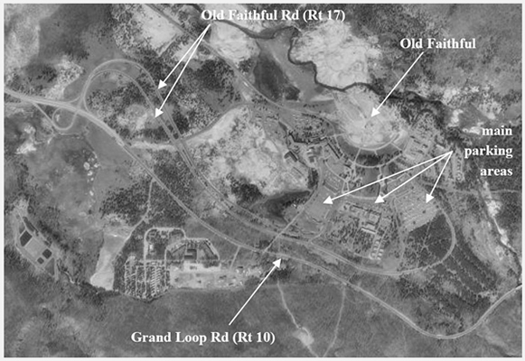
FIGURE A.14 RSA SITE (YELLOWSTONE NATIONAL PARK)
 |
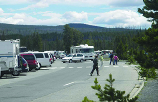 |
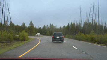
| Old Faithful Road | part of main parking area near Old Faithful geyser |
FIGURE A.15 VIEWS OF RSA SITE (YELLOWSTONE NATIONAL PARK)
KEY RSA FINDINGS AND SUGGESTIONS:
Since construction of the interchange replacement was expected to start no sooner than 2009, about four years after the RSA, the RSA also included a review of existing roads to identify low-cost countermeasures that could be implemented on an interim basis before the start of the planned improvements. The focus of the RSA was the existing Old Faithful Road between the Old Faithful interchange and the geyser site, including the geyser parking area, as shown in FIGURES A.14 and A.15. The key findings and suggestions of the RSA are summarized in TABLE A.12. In its response, the owner undertook to consider the RSA team’s observations in the final choice of design options for access to the Old Faithful area, and to incorporate the RSA team’s interim suggestions for pedestrian safety into planned improvements to the Old Faithful area.
 |
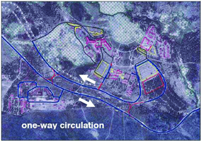 |
| Option 2B | Option 8A |
FIGURE A.16 PROPOSED IMPROVEMENTS TO OLD FAITHFUL AREA
| SELECTED SAFETY ISSUE (Number and Description) |
RISK RATING | SUGGESTIONS | |
|---|---|---|---|
| RSA of Conceptual Plans | |||
| 1 | Issues Associated with Concept 2B:
|
B |
|
| 2 | Issues Associated with Concept 8/8A:
|
C |
|
| RSA of Existing Roads | |||
| 3 | Pedestrian Conflicts:
|
D | Parking Area:
Grand Loop Road:
|
| 4 | Conflicts in Old Faithful Loop Parking Area | B |
|
| 5 | Signing and Wayfinding:
|
C | Vehicle Signing:
Pedestrian Signing:
|
| 6 | Old Faithful Interchange | D | Interim measures:
Ultimate measure:
|
KEY LESSONS LEARNED:
The RSA team and process may need to accommodate very specific demands and conditions. The Old Faithful area represented a challenging environment in which to plan and implement road improvements. Any proposed improvements were subject to environmental and historical constraints, including fragile hydrothermal features and a desire to stay within existing roadway footprints. At the same time, demands on the transportation infrastructure were considerable. The roadways had to accommodate high concentrations of visitors, which often mixed with wildlife using the roadway corridors. About 90 percent of Old Faithful vehicle traffic was composed of Park visitors, with the result that a large proportion of drivers were unfamiliar with the road network, and potentially were elderly retirees or were distracted by navigation demands. Traffic volumes varied widely, reflecting large seasonal variations and, on Old Faithful Road, substantial outbound peaks associated with a mass exodus following geyser eruptions. Similarly, within the Old Faithful visitor and parking area, conflicting pedestrian and vehicle traffic both peaked following the regular geyser eruptions. These factors, which were unique to the Park roadway environment, resulted in specific demands and constraints, particularly regarding suggested mitigation measures.
See also the discussion of “Key Factors for Success” and “Lessons Learned” in the main text.
| < Previous | Table of Content |

