U.S. Department of Transportation
Federal Highway Administration
1200 New Jersey Avenue, SE
Washington, DC 20590
202-366-4000
| < Previous | Table of Content | Next > |
Much has been written in recent years regarding many of the successful non-motorized programs in western Europe, including The Netherlands, Germany, England, and Switzerland. This lesson includes excerpts from a 1994 Federal Highway Administration report entitled FHWA Study Tour for Pedestrian and Bicyclist Safety in England, Germany, and The Netherlands, specifically those sections that describe innovative European approaches to bicycle and pedestrian facility design.
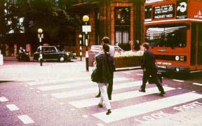
Figure 23-1. Zebra crossing with belisha beacons in London.
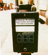
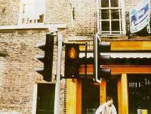
Figure 23-3. Pedestrian green man (WALK) and red man
(DON'T WALK) signal displays.
Figure 23-4. Toucan crossings in Great Britain provide separate
pedestrian and
bicyclist signals where trails cross roadways.
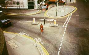
FIGURE 23-5. Pedestrian pavement messages and refuge islands.
FIGURE 23-6. Pedestrian barriers (separators) are
used extensively in London
to channel pedestrians to preferred
crossing locations.
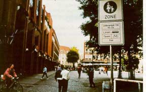
Figure 23-7. Pedestrian mall in Munster, Germany.
A flashing yellow indicator has been tested in The Netherlands (along with legal regulations) in some simple situations instead of a solid red ball for pedestrian signals. The symbol used for the yellow indicator is a triangle with an exclamation point inside it. The flashing yellow tells pedestrians that they may cross at their own risk, but other traffic has priority. The zebra crosswalk markings are removed at such locations to avoid suggesting that pedestrians have priority in crossing. The pedestrian green is an exclusive movement and, therefore, should be conflictfree. The motivations for testing this symbol include the following:
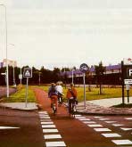
FIGURE 23-8. Some bicycle paths parallel roadways,
such as this one in Groningen, The Netherlands.
Another device tested in The Netherlands was a "pedestrian sender." This device provides a means for signal preemption for vulnerable pedestrians, including the visually and mobility impaired The pedestrian sender is similar to the emergency beepers used by the elderly and impaired to call for help. This device influences the traffic controller by doubling the pedestrian green time, activating an acoustic signal, and preventing conflicting traffic movements. No information about providing a directional indication to the vulnerable pedestrian was available. The results of a questionnaire indicated great enthusiasm for the pedestrian sender. The survey also indicated no misuse of the device.
While pedestrian improvements in Delft were said to lag behind bicycle facilities, pedestrian signals were installed at selected intersections in that city. A green man, yellow triangle, and red man were used for the WALK, DON'T START (clearance), and DON'T WALK intervals, respectively. Zebra-striped crosswalks are commonly used at pedestrian crossings.
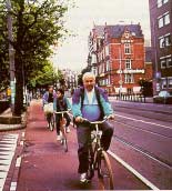
Figure 23-9. Typical bicycle lanes in The Netherlands
are often reddish
in color and
wide enough for two cyclists
to ride side-by-side.
In The Netherlands, separate bicycle signals are commonly used at arterial
intersections that have bike lanes and high volumes of bicyclists and
motor vehicle traffic. The bicyclist signals are vertical red, amber,
and green bicycle symbols mounted on a pole, as shown in figure 23-11.
They are located either next to the vehicle signal head (i.e., using
the same 20- centimeter diameter signal face as the vehicle signal)
or at a lower level (1 meter high) using a smaller size signal face
(7 to 7.5 centimeter).
The signal indications are all steady (i.e., no flashing indications),
and there is typically an advance green phase for bicyclists, with
a simultaneous red phase for right-turning motor vehicles. According
to one local official, levels of compliance with the signal are generally
not very high.
In some cities, such as The Hague and Groningen, a special bicycle
phase allows bicyclists in the bike lane to proceed straight before
motor vehicles (i.e., right-turning traffic) are allowed to proceed.
Motor vehicles are not allowed to turn right on red in The Netherlands,
although bicyclists are allowed to do so in certain cities and locations.
Bicycle lanes are not typically placed to the right of parked cars,
since motorists cannot see bicyclists as easily. It is common for
bicycle lanes to end before intersections. Mixing traffic before
an intersection promotes anticipation and interaction among road
users at the crossing. Otherwise, automobile drivers turning right
often are not fully aware of bicyclists and moped riders coming
from an adjacent bicycle lane.
Renting a one- or three-speed bicycle in The Netherlands is relatively inexpensive, costing approximately 10 guilders (about US$6) per day or about 50 guilders (US$30) per week. Bicycle rental shops are located throughout towns and cities, commonly at train stations. Information on bicycle rentals is provided at local hotels.
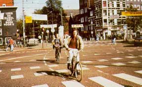
Figure 23-10. Bike lanes are sometimes marked through intersections.
As observed in Munster, bike paths are typically 1.6 meter wide (one direction on each side of the street), and the separation between cars and the bike path is generally 0.7 meters wide. Some areas are narrower in cases where sufficient room does not exist. This type of facility was originally promoted in the 1940's as a means to eliminate the "hindrance" to cars that was caused by bikes. They are now retained to separate cars and bicyclists for safety purposes.
Bike tracks are generally paths through the countryside and are signed routes. They are generally not paved.
Bus lanes that can also be used by bikes require a width of 4.5 meters or more to allow buses to easily and safely overtake cyclists when necessary. As shown in figure 23-13, these facilities are signed and marked with a bus and bike symbol.
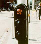
Figure 23-11. Bicycle signal used in Amsterdam.
Intersection improvements that facilitate bike travel include an advance stop line that allows bicyclists to exit sidewalk paths to turn left in front of motorized traffic. This allows a safer path for left-turning cyclists, provides better visual contact between bikes and cars, and allows cyclists to be away from vehicle exhaust. This design has been found to be safer than the traditional weave condition. Other signal treatments include special advance green signals for cyclists, and, in some cases, signals timed for bicycle traffic (based on a signal progression of approximately 9 mph). It was also observed during site visits that traffic signal heads in Munster had one green cycle signal head and two red cycle signal heads. This was done to improve the visibility of the red cycle signal.
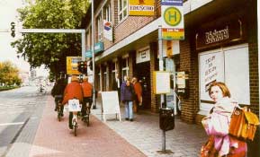
Figure 23-12. Off-street bicycle/pedestrian path in Germany.
Bike parking lockers and sheltered spaces are offered at some park-and-ride or park-and-bike lots at transit stations (see figure 23-14). Each bike locker can hold two bikes and provides better security for more expensive bicycles than at bicycle shelters. The rental fee for bike lockers is 20 deutsche marks US$11.70) per month, which is much less expensive than car parking. This particular lot has 108 car parking spaces, and is on the outskirts of the built-up area of the city. The construction cost is much less for bike parking facilities than for car parking. Furthermore, about 10 to 12 bikes can be parked in a single car parking space. Bike parking at the train station facilitates train-bike combination trips. Bikes are parked in monitored areas and can be parked for 4 days before being moved to a long-term parking area. This allows train commuters to leave their bikes at the train station over the weekend. The City of Munster is also planning a 4,000-space underground bicycle parking facility at the train station.
Separate signal heads for bicyclists, as well as separate distinctive signal heads for trolleys, are used where exclusive bus lanes exist (using vertical or horizontal white lines as bus signal displays). This often results in three sets of signal heads side-by-side (car, trolley, and bike).
Installing bike racks at corners also helps intersection visibility. The study team was shown an intersection where car parking at the intersection had previously created a visibility problem for motorists on the side street. The problem occurred even after NO PARKING signs were posted. Installing bike racks at the corner physically prevented car parking and opened up sight distances for side-street traffic.
Bicycle lanes with continuous lane markings are reserved solely for bicyclists. If the lane is dashed, cars and trucks may use the space only when no bicycle is present.
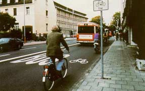
Figure 23-13. Lane used for buses and bicyclists only.
Text and photographs for this section were taken from:
FHWA Study Tour for Pedestrian and Bicyclist Safety in England, Germany, and The Netherlands, FHWA-PL-95-006, 1994.
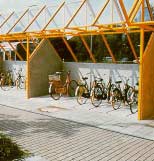 Figure 23-14. Illustration of bike shelters used in Germany. |
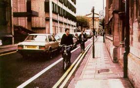 Figure 23-15. Contra-flow bicycle lane in Cambridge, England. |
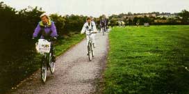 Figure 23-16. Bicycle trail on an abandoned railroad right of way south of York, England. |
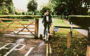 Figure 23-17. Entrance to bicycle trail is designed to restrict entry by motor vehicles. |
| < Previous | Table of Content | Next > |

