U.S. Department of Transportation
Federal Highway Administration
1200 New Jersey Avenue, SE
Washington, DC 20590
202-366-4000
![]()
U.S. Department of Transportation
Federal Highway Administration
View the PDF Version [715 KB]
In this issue:
Spotlight on Proven Countermeasures: Road Diet
Road Diet Case Study: Valencia Street, San Francisco
MAP-21 Provisions for Pedestrians
New Tools and Resources from USDOT
Since 2004, FHWA's Office of Safety has been working to aggressively reduce pedestrian deaths by focusing extra re- sources on the cities and states with the highest pedestrian fatalities and/or fatality rates. As mentioned in the Winter 2012 Pedestrian Forum Newsletter, FHWA revamped its approach to include more Focus Cities.
A Peer Exchange was held on August 1-2 in Miami, Florida with representatives from each focus city/state. Additionally there were participants from FHWA, NHTSA, and other organizations. To prepare for the exchange, each agency was asked to develop a brief profile that included crash trends, top concerns, success stories, and goals. These documents were distributed to each of the attendees at the meeting. Discussions were held on the first day to allow agency representatives to voice their pedestrian safety concerns, share information about their goals and discuss how they are addressing these safety issues.
The second day provided an opportunity to hear success stories from other agencies in the areas of engineering, en- forcement and education. At the conclusion of the ex- change, attendees were asked to write down short and long term goals that they would work on in the next 1-3 years. Participants viewed the exchange favorably:
As mentioned in the Winter 2012 edition of this newsletter, FHWA is promoting the use of 9 proven crash countermeasures–including three specifically for pedestrians: medians, Pedestrian Hybrid Beacons (PHB), and "Road Diets."
PHB was the subject of a webinar in November 2011, medians were covered in a webinar on May 30, and "Road Diets" will be covered on November 20, 2012. Please click on the links provided to view the recorded webinars and to register for upcoming ones. To receive information on future webinars, please use the e-subscription service provided here. Scroll down to "Pedestrian and Bicycle Safety" and select "subscribe" next to "Pedestrian Webinar."
See page 2 of this newsletter for more details on "Road Diets," as well as a case study showing their effectiveness. PHB will be
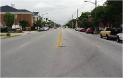
Before Road Diet.
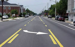
After Road Diet.
The FHWA strongly encourages the use of "road diets" (roadway reconfiguration) where appropriate. The classic "road diet," involves converting an undivided four lane roadway into three lanes made up of two through lanes and a center two-way left turn lane. The reduction of lanes allows the roadway to be reallocated for other uses such as bike lanes, pedestrian crossing islands, and/or parking. Road diets have multiple safety and operational benefits for vehicles as well as pedestrians, such as:
Roadways with Average Daily Traffic (ADT) of 20,000 or less may be good candidates for a road diet and should be evaluated for feasibility. It has been shown that roads with 15,000 ADT or less had very good results in the areas of safety, operations,
Driveway density, transit routes, the number and design of intersections along the corridor, as well as operational characteristics are some considerations to be evaluated before deciding to implement a road diet. Road diets can be low cost if planned in conjunction with reconstruction or simple overlay projects, since a road diet mostly consists of restriping.
Background: Valencia Street is a 19.1 m (62 ft 6 in)–wide street through a shared-use area of mostly two to three-story buildings, and metered on-street parking on both sides. The street lies in a grid pattern and is paralleled by four other north-south arterials.
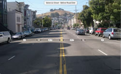
Valencia Street Before Road Diet (above)
and after (below).
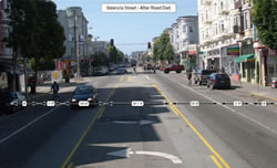
Before the project, the arterial was a four-lane street with an Average Daily Traffic (ADT) of approximately 22,000 vehicles per day. A motor coach transit line with a headway of 15 to 20 minutes travels along the street. There is a heavy pedestrian presence because the street is a popular area with restaurants, nightclubs, and a variety of shops. All intersections have signals.
Solution: After a series of community meetings and public hearings, the city Board of Supervisors voted on a resolution calling for the removal of two travel lanes and the installation of bicycle lanes and a median lane for left turns on a one-year trial basis. To minimize the loss of capacity along Valencia Street and reduce the impacts to parallel streets, changes were made to the signal timing along Valencia Street and Guerrero Street one block to the west. On Valencia Street, the green time was maximized for the Valencia Street split while still maintaining time for pedestrians crossing Valencia Street. On Guerrero Street, the signal offsets were modified to promote a smoother progression at 25 mph, as the speed limit was lowered from 30 mph to address citizen concerns along the primarily residential street. The speed limit change and signal timing modifications were intended to address speeding concerns and help mitigate the likely increase of traffic along Guerrero Street.
Results: Total collisions during the 2-year period following implementation declined by 20 percent. Although bicycle collisions increased by approximately 50 percent, the increase was outpaced by the 140 percent rise in ridership along the street. This net decrease in collision rate for cyclists mirrors the increased comfort cyclists report feeling along the street. Collisions involving pedestrians dropped by 36 percent, even though the street has thrived commercially and attracted even more foot traffic.
| Collision Type | Before | After | % Change |
|---|---|---|---|
| Total | 5.9 | 4.7 | -20 |
| Midblock | 1.1 | 1.4 | -27 |
| Intersec- | 4.9 | 3.4 | -31 |
| Bicycle | 0.67 | 1.0 | +49 |
| Pedestrian | 0.83 | 0.53 | -36 |
This is an excerpt of a Case Study contained in Bikesafe: Bicycle Countermeasure Selection System which will soon be revised by the FHWA. Read the full case study here.
The Moving Ahead for Progress in the 21st Century Act (MAP-21) was enacted July 6, 2012. New program requirements became effective October 1, 2012.
MAP-21 has few new provisions directly affecting pedestrians. Pedestrian projects remain broadly eligible across the Federal-aid highway program, however, MAP-21 consolidated some programs used mostly for pedestrian projects: the Transportation Enhancement (TE) Activities, Recreational Trails Program (RTP), and Safe Routes to School (SRTS) Program were combined into a new Transportation Alternatives Program (TAP).
Funding for these programs had been $1.1 billion annually, but was reduced to just over $800 million annually, with funding set aside for the RTP. Projects eligible under SRTS remain eligible, but there is no funding set aside for SRTS projects, so some of the SRTS Program requirements no longer exist.
See https://www.fhwa.dot.gov/ map21/guidance/ for FHWA Guidance on Map-21 as it becomes available.
Federal responsibility for the Safe Routes to School Program has been transferred from the Office of Safety to the Office of Planning, Environment, and Realty. However, FHWA will continue to have close coordination between these offices.
Corvallis, Oregon – GOLD
Rochester, Minnesota – BRONZE
The Pedestrian and Bicycle Information Center (PBIC) announced nine new Walk Friendly Communities (WFC). The "Walk Friendly" title means a city or town is being recognized for its success in working to improve a wide range of conditions related to walking–including safety, mobility, access, and comfort. PBIC recognizes these nine communities for their commitment to improving walkability and pedestrian safety:
Gold Level
Washington, D.C.
Silver Level
Long Beach, Ca.
Redwood City, Ca.
Bronze Level
Gainesville, Fla.
Fort Collins, Co.
Northampton,
Mass.
Rochester, Minn.
Essex Junction, Vt.
Shorewood, Wisc.
"We are very excited to add nine to the Walk Friendly Communities roster," said Carl Sundstrom, WFC program manager. "These communities represent a true cross-section of America, ranging from the nation's capital to the small town of Essex Junction, Vt., population 9,300. The variety shows how much this program continues to grow cities and towns of all sizes and types can create vibrant and walkable places."
There are now 33 Walk Friendly Communities across the nation. To date, Seattle, Wash., is the only Platinumlevel Walk Friendly Community.
The Walk Friendly Community designation, awarded from bronze to platinum, is given to applicant communities that have demonstrated a commitment to improving and sussustaining walkability and pedestrian safety through comprehensive programs, plans and policies.
At the core of the WFC program is a comprehensive assessment tool that evaluates community walkability and pedestrian safety through questions related to engineering, education, encouragement, enforcement, evaluation and planning. The assessment tool questions are intended to both evaluate conditions for walking and provide communities with feedback and ideas for promoting pedestrian safety and activity. Modeled after the League of American Bicyclists' "Bicycle Friendly Communities," WFC distinguishes cities and towns that are leading the way in walkability. WFC is the first program to highlight communities for their walkability initiatives and programs, while also offering feedback to assist communities in improving walkability.
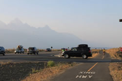
The crossing of a newly constructed
shared
use path near the intersection of
Gros
Ventre Road and Highway
89 in the
Grand Teton National Park.
FHWA recently completed Bicycle RSA Guidelines and Prompt Lists and these have been used to conduct RSAs in Atlanta, Georgia; on the George Washington Memorial Parkway in Northern Virginia; and most recently in the Grand Teton National Park. The three day RSA process was used to review the transportation facilities, focusing on the interaction of cyclists on a newly constructed shared use path in Grand Teton. The RSA also looked at the needs and behavior of drivers, pedestrians and bicyclists.
The RSA was conducted at the intersection of Gros Ventre Road and US Highway 26/89/191 and included the crossing of a newly constructed shared use path to the east of the roadway intersection. Users of the Gros Ventre intersection have witnessed many near-misses between cyclists and motor vehicles. The Grand Teton National Park requested an RSA in response to these concerns.
While the shared use path provides cyclists, pedestrians, and other non-motorized user's space separated from the high-speed, high-volume motorized vehicle traffic on US 26/89/191, there are certain challenges at the intersections of the roadway and path that were assessed by the RSA team. The team developed shortrange, intermediate, and longrange preliminary suggestions.
Short-range improvements included increased signage and pavement markings for both the roadways and the shared use path along with methods to help slow traffic down prior to the intersection. Intermediate and long range improvements included suggestions such as relocating the shared use path crossing, using a variety of tunnel configurations, and possibly construction of a roundabout. Many of the suggestions provide safety benefits for non-motorized users, but also to motor vehicles and, in some cases, to local wildlife through speed reduction measures.
As the park continues to promote non-motorized travel, BRSA's will be an invaluable tool to proactively evaluate and address safety concerns.
This study built upon the work of Blomberg and Cleven (2006) in Arizona, where they developed and pilot-tested the concept of Heed the Speed—a neighborhood-based combination of enforcement, education, and modest engineering designed to reduce vehicle speeds and benefit pedestrian safety. The current program was expanded and applied to Philadelphia, Pennsylvania, in an attempt to determine if reducing speeds in neighborhoods would lead to a reduction in pedestrian-involved crashes. (July 2012; DOT HS 811 607)

This report reviews the pedestrian and bicyclist safety research literature in print as of 2007. It summarizes and synthesizes the key studies, evaluates existing knowledge and identifies research gaps and provides recommendations for future direction.
The review includes studies identified through searches of the TRIS, TRANSDOC, IRRD, PubMed, PsychLit, and SafetyLit automated databases and through contacts with research institutions and researchers. It also draws on the background papers and recommendations from the April 2000 NHTSA/FHWA Pedestrian and Bicycle Strategic Planning Research Workshops and from the Bicycle Safety 2000 Conference.
Studies are organized into areas highlighting studies on pedestrian safety with emphasis on demographic characteristics, highrisk environments, travel behavior, injury typing and injury profiles and others. Similar grouping is made for studies on bicyclist safety. (June 2012; DOT HS 811 614)
For further information about pedestrian and bicycle safety research, contact Kristie Johnson, Research Psychologist, at Kristie.Johnson@dot.gov.
The web page includes the following 2000-2010 information:
The final report to Congress for the Nonmotorized Transportation Pilot Program (NTPP) is now available. The NTPP provided over $25 million each to four communities (Marin County, CA, Columbia, MO, Sheboygan County, WI, and Minneapolis, MN) to improve their walking and bicycling networks.
FHWA was tasked with quantifying the community benefits of improved conditions for walking and biking, and the results are discussed in the report to Congress. The report was mentioned in the Secretary of Transportation's Fastlane blog.
The U.S. DOT's Joint Programs Office is planning to invest roughly $2 million over the next 2 years in the development of V2P safety research program. This project will engage automobile manufacturers, transit industry and pedestrian safety stakeholders to develop operational concepts and requirements of a suite of safety application to warn drivers of nearby pedestrian movements.
The effort will also possibly look at warning pedestrians of nearby vehicles on a continuing basis both spatially and temporally. This project will also study the state of practice and assess current technologies and devices for their maturity and suitability to support any pedestrian collision warning applications.

Tamara Redmon, Pedestrian Safety Program Manager
Federal Highway Administration
1200 New Jersey Avenue SE
Room E71-303
Washington, DC 20590
Phone: 202-366-4077
Fax: 202-366-3222
E-mail: tamara.redmon@dot.gov
This Pedestrian Forum is available on the Web at http://safety.fhwa.dot.gov/ped_bike/pedforum/. To receive information on future newsletters, please use the e-subscription service provided on this site: http://safety.fhwa.dot.gov/esubscribe.cfm#ped. Scroll down to "Pedestrian and Bicycle Safety" and select "subscribe" next to "Pedestrian Forum."
The promotion of transportation alternatives is a high priority of the U.S. Department of Transportation. Ideally, each community provides safe and convenient transportation choices to all citizens, whether it's by walking, bicycling, transit, or driving. Each year, unfortunately, pedestrian fatalities comprise about 13 percent of all traffic fatalities and there are approximately 4,200 pedestrian deaths. Another 70,000 pedestrians are injured in roadway crashes annually. The numbers are improving, but we still have a ways to go. Pedestrian safety improvements depend on an integrated approach that involves the four E's: Engineering, Enforcement, Education, and Emergency Services. The Pedestrian Forum highlights recent pedestrian safety activities related to the four E's that will help save lives.

