Road Safety Audits (RSA)

December 6, 2006
Download Version
PDF [1.85 MB]
BACKGROUND/ INTRODUCTION
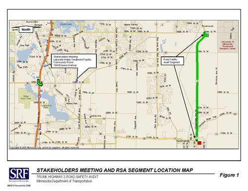
In Fall 2006, the Minnesota Department of Transportation (Mn/DOT) requested a road safety audit (RSA) of a segment of TH 3 (see Figure 1). This segment of TH 3 is located in the City of Farmington and Empire Township and is perceived by local officials, members of the community and adjacent residents to have safety issues due to crash history and individual observations and experiences. SRF Consulting Group, Inc. was chosen by Mn/DOT to complete the RSA project for TH 3. The process for the TH 3 RSA was generally modeled after the Mn/DOT/MN DPS Central Safety Fund’s Road Safety Audits completed in Summer 2006.
Specifically, RSAs are a tool where the safety performance, design and operation of roadways and intersections are examined by an independent multi-disciplinary team, and short-term, usually low-cost mitigating improvements or strategies (and in this case, midand long-range as well) are identified and suggested for implementation. RSAs were recognized in the Minnesota Comprehensive Highway Safety Plan as one of 15 critical strategies that can reduce traffic-related death and injury in Minnesota.
Implementing a variety of safety improvements for roadways or intersections with significant crash histories may help prevent future crashes. Motor vehicle crashes are complex occurrences that often have multiple contributors to the event (e.g., driver characteristics or behavior, road conditions, vehicle conditions/equipment) and fixing and/or improving single elements (e.g., signing) may not be completely successful in correcting or reducing future crashes. As pointed out by the Minnesota Comprehensive Highway Safety Plan, engineering modifications, when combined with improvements in enforcement, education, and emergency medical services are more likely to be successful in preventing or reducing the severity of future crashes than any single remedy alone.
TH 3 RSA PROCESS
The independent road safety audit team visited the corridor on November 15-16, 2006, observing the existing conditions and vehicle operations on TH 3 at peak traffic times in the morning and the afternoon. Immediately preceding the site visit, a safety stakeholder meeting was held to familiarize the audit team with the stakeholders’ experience with the operation of the TH 3 corridor (See Appendix A for a list of attendees). A final stakeholders meeting will be held upon the finalization of this report to discuss its findings. Mn/DOT is encouraged to consider the report’s recommendations and respond in writing with its plans for implementation of the report’s findings.
However, not all of the recommendations made in the course of this process can be implemented by Mn/DOT. The four most significant recommendations brought forth by this road safety audit should be addressed by a combination of State and local officials. These recommendations fall into the following areas:
- Speed limit changes: After examination of data, crash history and current and planned development, the RSA Team believed a short-term safety improvement could be implemented by moving the 45 mph to 55 mph speed limit change point on TH 3 that currently exists north of Farmington. The Team recommended the change point be moved north of the CSAH 66 intersection with TH 3 and a 50 mph transitional speed limit be instituted for approximately one mile until the change point to 55 mph at the intersection of TH 3 and 197th Street. When the conversion of TH 3 to a three-lane section with exclusive left-turn lanes at the intersections and with two-way left-turn lanes in between is completed as a midterm improvement, the speed limit on this section should be re-studied.
- Education: A review of the crash history of this segment revealed a startling over-involvement of young drivers in crashes on this corridor. It also indicated greater than average incidences of inattentive, aggressive and impaired driving behaviors that were cited as factors in these crashes. Resources must be pursued for public educational efforts to alert schools and the community at large to these trends and to the danger posed by these driving behaviors.
- Enforcement: Educational efforts are most effective when reinforced with aggressive enforcement. Law enforcement resources for targeted campaigns against inattentive, aggressive and impaired driving are scarce. Driver behavior is unlikely to change with education alone, therefore law enforcement funding must be augmented to allow for the enforcement levels necessary to change driver behavior on this corridor.
- Consistency of corridor signing, striping and lighting: Spot safety improvements to areas of this corridor have occurred as the roadway was updated for maintenance or modified to accommodate development. This has created an inconsistent driving environment that can be confusing to drivers. Signage, striping and lighting should be examined and modified for consistency to assist drivers as they navigate the area.
The following report provides a crash history summary, general observations and an outline of the audit team’s findings for the corridor and for each site reviewed. It contains suggestions for specific safety improvements in the short-, mid- and long-term that may be considered in order to improve the overall safety performance of this corridor. The ultimate goal of a Road Safety Audit process is to increase safety (i.e., to reduce fatal and injury crashes) through engineering, education, enforcement and/or other strategies.
Road Safety Audit Team
The independent, multi-disciplinary RSA team for the TH 3 RSA was comprised of a number of experienced professionals and experts with many years of traffic safety experience.
- David Engstrom, (Mn/DOT) State Traffic Safety Engineer, Project Manager
- Karen Sprattler, (SRF) Senior Associate, Project Manager
- Kevin Kittridge, (SRF) Minnesota State Patrol (Retired), Team Leader
- Patrick Corkle, (SRF) Senior Associate, Traffic Engineer
- Jeff Bednar, (SRF) Senior Traffic Engineering Specialist
- Michael Schweyen, (Mn/DOT Rochester/District 6) District Traffic Engineer
- Ted Schoenecker, (Washington County) County Traffic Engineer
- Julie Whitcher, (Mn/DOT Central Office Traffic) Senior Engineer
- Dan Brannan, (Mn/DOT Central Office Traffic) Traffic Safety Specialist
- Brad Anderson, (Mn/DOT Central Office Geometrics) Senior Engineering Specialist
- David Burns, (3M Traffic Safety Systems) Senior Analyst
Information Sources
Several sources of information were used in the RSA process. Crash data from 2002 through September of 2006 was examined for trends and patterns using GIS-based mapping, SRF’s Crash Analysis Tool, and local law enforcement crash reports. Additional information provided by Mn/DOT provided insight into issues concerning roadway safety. Specific resources used in the analysis include:
- Mn/DOT TIS Crash Data Base (2002 – September 2006)
- Mn/DOT 2005 Traffic Volume Flow Map
- TH 3 RSA Corridor Plan Sheets
- TH 3 RSA Crash Summary, Collision Diagrams and Detailed Crash Summaries
- TH 3 RSA Corridor Mapping and Aerial Photography
- TH 3 RSA Corridor Law Enforcement Crash Reports
- TH 3 RSA Corridor Video Log and Still Photographs
- TH 3 RSA Corridor Field Inspections and Field notes
- Mn/DOT staff knowledge of TH 3 Corridor histories and issues
with a primary focus on the segment of TH 3 from 194th Street to 209th Street. Note: stakeholder issues of concern and audit team recommendations are not listed in a prioritized order.
Stakeholder-Identified Issues and Problems
- TH 3, an “A” Minor Arterial, is identified by Mn/DOT as a “Preservation” corridor with no major improvements programmed within current funding horizons
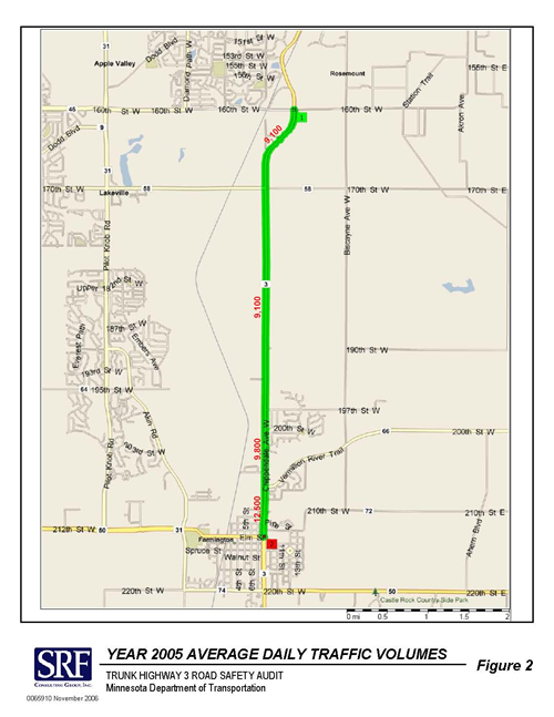
- TH 3 carries moderate traffic volumes ranging from 9,100 to 12,500 Average Daily Traffic (ADT) volumes (see Figure 2). Generally speaking, a two-lane roadway with ADT volumes of 8,000 and above begins to experience problems with gap availability and turning traffic conflicts
- According to local jurisdictions and residents, the posted 55 mph speed limit from 194th to 209th Streets doesn’t acknowledge the residential character of the area
- Significant heavy-commercial vehicle traffic is present
- Higher access density exists from 194th to 209th Streets than for the rest of the segment
- Lack of gaps in the traffic stream cause problems for cross street approaches
- Aggressive driver behavior is an issue on this segment (e.g., tailgating)
- Differing perspectives exist on excessive speeding on this corridor (residents and law enforcement have different perceptions)
- Significant pending or future development is slated to occur along the corridor
- A trail is located along the west side of the roadway, but much of the development is on the east-side with no provisions for crossings or crosswalks
- A future extension of 195th Street is planned from CSAH 31 to TH 3
- Access management plan implementation is a long range goal, but little is being done to actively remove access points. MnDOT is working with development as it happens to identify acceptable access locations
- Mn/DOT currently manages the TH 3 corridor access as a “Principal” Arterial
- Inconsistent spot improvements have occurred due to new development
Crash History:
- There were 103 recorded crashes in 4.75 years (2002 through September 2006) for the entire corridor; 34 crashes in the primary focus area of 194th to 209th Streets.
- The crash and crash severity rates for the TH 3 corridor as a whole, the primary focus area of 194th to 209th Streets, Metro and Statewide averages are listed below. When compared to all similar sections in the Metro area, the TH 3 corridor ranks 49th out of a total of 75 similar roadways for crash rate; 43rd out of 75 for crash severity.
| Rate |
Statewide |
Metro |
TH 3 Corridor |
Primary Focus Area |
| Crash rate |
0.9 |
1.2 |
0.9 |
1.2 |
| Severity rate |
1.4 |
1.8 |
1.6 |
2.0 |
- The crash diagrams were distributed as follows:
| Crash Type |
Statewide Crash Diagram |
TH 3 Corridor |
Primary Focus Segment |
| Rear-end |
28% |
28% |
44% |
| Right-angle |
19% |
23% |
19% |
| Other |
11% |
21% |
4% |
| Run off road |
15% |
13% |
19% |
| Sideswipe |
3% |
6% |
0% |
| Head-on |
5% |
5% |
7% |
| Left-turn |
5% |
4% |
7% |
- Contributing factors involved in crashes occurring on the TH 3 corridor included:
| Contributing Factor |
Statewide Crashes
(Mult. Veh.) |
Statewide Crashes
(Single Veh.) |
TH 3 Corridor
(75 Mult. Veh.; 28 Single Veh.) |
Primary Focus Segment
(21 Mult. Veh; 13 Single Veh.) |
| Driver inattention |
25% |
14% |
22% |
28% |
| Failure to yield right-of-way |
18% |
0.3% |
12% |
7% |
| Alcohol |
2% |
9% |
5% |
8% |
| Improper passing/lane use |
2% |
0.4% |
6% |
12% |
| Following too closely |
12% |
0.4% |
4% |
7% |
| Disregard for traffic control |
5% |
0.6% |
4% |
0% |
| Unsafe speed |
8% |
26% |
4% |
7% |
- More than 40% of the crashes involved injury (2 non-intersection fatalities)
- Vehicle Direction: 40% northbound, 35% southbound, 15% other, 10% eastbound
- Vehicle Direction in the primary focus segment (194th Street to 209th Street) - 53% northbound, 36% southbound, 9% westbound and 2% eastbound
- Nearly half of the crashes (48%) occurred under dark lighting conditions in locations with and without intersection/street lighting in the primary focus segment (194th Street to 209th Street)
General Observations:
- Younger drivers (24 years and under) appear to be significantly over represented in the crash experience of the corridor and in the primary focus segment of 194th Street to 209th Street in particular.
| Driver Age Range |
Statewide Crashes |
TH 3 Corridor |
Primary Focus Segment |
| 24 and under |
29% |
37% |
49% |
| 19 and under |
14% |
24% |
33% |
- Driver inattention is cited most often as a contributing factor in the crash history of the corridor and primary focus segment.
- Aggressive driver behaviors (failure to yield right-of-way, improper passing/lane use, following too closely, disregard for traffic control and unsafe speed) also appear as principal contributing factors in the crash history of the corridor and primary focus segment
- Aggressive driver behavior was observed during the TH 3 RSA field reviews of the study area (particularly tailgating/following too closely and improper passing)
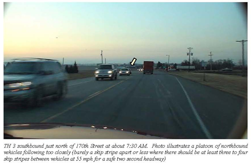
- The higher occurrence of rear-end crashes may also be indicative of driver inattention or aggressive driver behavior
- Significant heavy-commercial vehicle traffic was observed (+/- 10% of total traffic)
- Intersection treatments are inconsistent; namely intersection lighting design and location varied significantly. There were intersections with and without lighting, intersections with and without junction signing, intersections with and without bypass and turn lanes
- Higher access density is present from 194th Street to 209th Street
- West side - 3 intersections and 33 driveways (36 conflict points)
- East side - 8 intersections and 22 driveways (30 conflict points)
- In conjunction with the higher access density, there is a significant amount of roadside clutter (e.g., signing, mailboxes, garbage containers, etc.) throughout the primary focus segment (194th Street to 209th Street) requiring a driver to process a great deal of information and make decisions in a short period of time
TH 3 Road Safety Audit Corridor Wide Recommendations
Short-Range Improvements to Consider for Immediate Implementation:
Engineering Improvements and Strategies
- Improved TH 3 signing and striping should focus on:
- Bypass lane signing/striping, to conform to the new Mn/DOT 2007 traffic engineering standards
- Junction signing, to conform to the new Mn/DOT 2007 traffic engineering standards
- Install “No Passing On Shoulder” signing at intersections without bypass lanes and in other areas along the corridor where necessary to aid in driver compliance and violation enforcement
- Consider Dynamic Speed Display signs at each end of the primary focus area (194th Street to 209th Street) to raise the driver’s awareness of their vehicle speed
- Install larger street name signs with the 9” blade and 6” text height
- Install additional chevrons on the curves south of 160th Street
- Install “Watch For Turning Vehicles” or other appropriate driver awareness signing in the primary focus area (194th to 209th Streets), possibly including advisory speed plaques (no guidelines exist for installation per MUTCD)
- Remove or reduce potentially unnecessary signing and roadside clutter to reduce driver processing and decision workload (e.g., standardize mailboxes, etc.)
- Improve intersection/roadway lighting to focus on consistent intersection/roadway lighting design, application and location, especially in areas with significant nighttime crash issues
- Conduct a posted speed zone review to focus on:
- The location of the 55 to 45 mph speed limit change point location at 209th Street should be reviewed. RSA Team members had difficulty in discerning differences in the roadway character at this particular point. The Team recommends that moving the speed change point north of CSAH 66 area should be considered.
- Instituting a 50 mph transitional speed limit zone from the revised change point north of CSAH 66 to 197th Street during this transitional development phase. Note: When Mid-Term recommendation #4 is implemented, the speed limit should be re-studied on this segment of TH 3.
Enforcement Strategies
- Local and/or county officials must budget for increased traffic enforcement and targeted enforcement programs, including increased commercial vehicle enforcement
Education Strategies
- Expand the Dakota County Safe Communities Programs
- Focus on Younger Driver education programs
- Implement a “Stop Tailgating” program similar to the Wright County Safe Communities effort
- Engage local media in a campaign to concur with targeted enforcement of aggressive driver behavior and commercial vehicle violations
- Enhance the Dakota County Technical College Commercial Driver’s Education Training Program to include an enhanced safety component for drivers as it is likely they may work for local companies
Mid-Range Improvements to Consider (2 to 10 years):
- Accelerate access consolidation, particularly near intersection locations where local agency initiative may be able to encourage property owners to develop shared access plans
- Local agencies and developers should consider improvements to better identify the primary focus area (194th Street to 209th Street) as a residential community (i.e., adding a gateway element that could include street lighting, curbing, monuments/landscaping features outside of the clear zone and/or other themes that help drivers recognize the need to drive differently in this area)
- Work with the communities to identify where intersection controls (traffic signals, roundabouts, medians, etc.) are most likely to be installed to meet spacing guidelines in the short term and develop plans to direct traffic to these potential controlled intersections
- Conversion of TH 3 to a three-lane section (exclusive left-turn lanes at the intersections with two-way left-turn lanes in between) from the four-lane divided section north of Hwy 50 (Elm Street) to 194th Street or the northerly extent of significant development
- Review trail/sidewalk plans and consider locations for grade-separated trail/sidewalk crossings. At-grade crossings at uncontrolled intersections should be discouraged
Long-Range Improvements to Consider (> 20 years):
- Continue to pursue implementation of the TH 3 access management plan and future upgrade to a four-lane divided section through the TH 3 corridor
TH 3 ROAD SAFETY AUDIT - SPECIFIC INTERSECTIONS
The TH 3 RSA Team identified a number of intersections to be studied, through a review of crash data and citizen concerns. The following is a summary of the crash history, field observations and improvements to consider for these intersections.
RSA SITE: TH 3 AND CSAH 46/160TH STREET
Crash History:
- 9 recorded crashes in 4.75 years
- 4 rear-end, 4 right-angle and 1 other
- > 40% southbound, >30% northbound, > 20% eastbound
- > 50% of the crashes involved injury
- > 50% involved failure to yield right-of-way
- > 50% occurred in March through May
- > 40% occurred from 6 – 10 AM
General Observations:
- A multi-phase, fully actuated traffic signal system is present (isolated/not coordinated)
- An Advanced Warning Flasher System on TH 3 is operating (Prepare To Stop When Flashing)
- There is a multi-lane divided section on CSAH 46/160th Street
- Multi-lane undivided approaches exist on TH 3
- A high level of advance signing is present
- Circular signal indications are incandescent, while the arrow indications are LED
Recommendations:
Short-Range Improvements to Consider for Immediate Implementation:
- Change out incandescent circular signal indications with LED indications to improve visibility
- Review Yellow and All-Red signal timing clearance intervals
Mid-Range Improvements to Consider (2 to 10 years):
- Consider installation of raised median island channelization on TH 3 to better define the roadway and provide positive guidance through the intersection for the driver
RSA SITE: TH 3 AND CSAH 58/170TH STREET
Crash History:
- 8 recorded crashes in 4.75 years
- 6 right-angle, 1 rear-end, and 1 other
- > 40% eastbound, >30% southbound, > 20% northbound
- > 60% of the crashes involved injury
- 75% involved failure to yield right-of-way
- 50% occurred in September through November
- 50% occurred from 6 – 10 AM
General Observations:
- Junction signing on TH 3 is too close to the intersection which creates a driver reaction and sight distance issue
- Non-breakaway light post in northwest corner is inside the clear zone
- Cross street approach Stop signs are 30” signs on the right side only
- Eastbound cross street approach is a two-lane approach and the westbound approach is a wider gravel (unmarked) approach operating as a two-lane approach
- Infrequently used weigh station/wayside rest on west-side is a security issue
- Current weigh station/wayside rest signing is confusing (conflicting messages – advanced sign says “All Vehicles Over 10,000 Lbs Enter Station” while secondary sign says “Weigh Station Closed”)
- Combination northbound right-turn/bypass lane is present
- Northbound bypass lane was used often due to many northbound left-turns
- Loose gravel on is present on the westbound approach
- No junction signing exists on the westbound approach
Recommendations:
Short-Range Improvements to Consider for Immediate Implementation:
- Drill the light post in the northwest corner to be breakaway compliant
- Install 36” Stop signs and consider the “gatepost” application (signs on both the left and right side) on the east and westbound approaches
- Review weigh station/wayside rest signing, consider fold up or portable signs only when needed
- Add junction signing on westbound approach
Mid-Range Improvements to Consider (2 to 10 years):
- Consider widening TH 3 to provide center left-turn lanes at this intersection
- Review traffic signal justification
- Consider removal of weigh station/wayside rest
RSA SITE: TH 3 AND 194TH STREET
Crash History:
- 2 recorded crashes in 4.75 years
- 1 rear-end and 1 run off road
- 100% northbound
- 100% of the crashes involved injury
- 50% involved unsafe speed, 50% driver inattention
- 100% occurred in March through August
- 100% occurred from 7 PM – 12 AM
General Observations:
- The southbound right-turn lane had previously been a southbound bypass lane
- The southbound right-turn lane was shortened so as to not be confused as a bypass lane
- There is a short three-lane segment at this intersection to provide north and southbound left-turn lanes
- The northbound right-turn lane feels narrow which may cause drivers to use the adjacent through lane as they slow to make their right-turn
- Trail/sidewalk system is missing links between segments; playfield exists to the northeast
Recommendations:
Short-Range Improvements to Consider for Immediate Implementation:
- Review southbound right-turn lane for deceleration length and restripe as necessary
- Review northbound right-turn lane for width and restripe as necessary
- Consider a southbound Dynamic Speed Display sign north of this location to alert drivers to their vehicle speeds
Mid-Range Improvements to Consider (2 to 10 years):
- Review traffic signal justification
- Consider trail/sidewalk system continuity and the need for a future grade separated trail/pedestrian crossing
RSA SITE: TH 3 AND 197TH STREET
Crash History:
- 2 recorded crashes in 4.75 years
- 1 rear-end and 1 run off road
- 67% southbound, 33% northbound
- 50% of the crashes involved injury
- 50% involved alcohol, 50% driver inattention
- 100% occurred in September through November
- 50% occurred from 12 AM – 6 AM
General Observations:
- The westbound Stop sign is obscured by vegetation
- Southbound bypass lane extends south to beyond the next driveway approach south of 197th Street
- No junction signing is present on TH 3
Recommendations:
Short-Range Improvements to Consider for Immediate Implementation:
- Trim vegetation from in front of westbound Stop sign
- Review southbound bypass lane signing and striping; comply with new Mn/DOT 2007 traffic engineering standards
RSA SITE: TH 3 AND 200TH STREET
Crash History:
- 2 recorded crashes in 4.75 years
- 1 right-angle and 1 run off road
- 33% southbound, 33% northbound, 33% westbound
- 50% of the crashes involved injury
- 50% involved failure to yield right-of-way, 50% improper passing or lane use
- 100% occurred in September through February
- 100% occurred from 4 PM – 7 PM
General Observations:
- Double solid yellow centerline extends through the intersection
- Southbound bypass lane extends south to beyond the frontage road approach south of 200th Street
- Highest westbound approach PM peak period delay observed was 127 seconds; others observed averaged 60 seconds which indicates a lack in mainline gaps
- Highest northbound approach speed observed was 67 mph; highest southbound approach speed observed was 78 mph. Most observed speeds were near the posted limit of 55 mph
Recommendations:
Short-Range Improvements to Consider for Immediate Implementation:
- Review southbound bypass lane signing and striping; comply with new Mn/DOT 2007 traffic engineering standards
- Remove double solid yellow centerline that extends through the intersection
RSA SITE: TH 3 AND 205TH STREET
Crash History:
- 4 recorded crashes in 4.75 years
- 2 rear-end, 1 run off road, 1 other
- 70% northbound, 30% southbound
- 50% of the crashes involved injury
- 50% involved driver inattention, 50% alcohol, 25% following too closely
- 50% occurred at night
- 50% occurred from 10 AM – 4 PM
- Crash severity rate was above Metro and Statewide average
General Observations:
- Existing southbound right-turn lane
- Existing northbound bypass lane
Recommendations:
Short-Range Improvements to Consider for Immediate Implementation:
- Review northbound bypass lane signing and striping; comply with new Mn/DOT 2007 traffic engineering standards
RSA SITE: TH 3 AND CSAH 66
Crash History:
- 6 recorded crashes in 4.75 years
- 3 rear-end, 1 right-angle, 1 run off road, 1 other
- > 50% southbound, > 30% northbound, > 10% westbound
- > 30% of the crashes involved injury
- > 80% involved driver inattention
- 50% occurred at night
- 50% occurred from 4 PM – 7 PM
- Crash severity rate was above Metro and Statewide average
General Observations:
- On the westbound approach, sight distance to the north is somewhat restricted by the guardrail, barrier wall and low hanging tree limbs
- There is a short three-lane segment at this intersection to provide north and southbound left-turn lanes
- There is an existing northbound right-turn lane
Recommendations:
Short-Range Improvements to Consider for Immediate Implementation:
- Review low hanging tree limb and trim if necessary
- Consider a westbound approach stop bar located at the point to which drivers should pull up to in order to see past the sight distance restrictions to the north
Mid-Range Improvements to Consider (2 to 10 years):
- Review traffic signal justification
RSA SITE: TH 3 AND 209TH STREET
Crash History:
- 5 recorded crashes in 4.75 years
- 3 rear-end, 1 right-angle, 1 other
- 50% northbound, 40% southbound, 10% westbound
- 60% of the crashes involved injury
- 40% involved driver inattention, 20% following too closely
- 60% occurred at night
- 40% occurred from 4 PM – 7 PM
General Observations:
- 209th Street provides primary access to the new commercial development on the east side
- This commercial development will soon generate a significant southbound left-turn demand at this intersection
- There is no southbound left-turn lane, impeding southbound left-turn traffic which will likely result in southbound through vehicles passing on the shoulder
- TH 3 posted speed limit is 45 mph to the south of this intersection and 55 mph to the north
- Conditions north and south of this speed limit change point do not appear to be significantly different at this time (but may have been in the past) and the consensus of the TH 3 RSA Team was that this may not be the proper speed change location
- There is an existing northbound right-turn lane
Recommendations:
Short Range Improvements to Consider for Immediate Implementation:
- Review existing posted speed limit change point, consider moving this change point north of CSAH 66 intersection
- Consider a northbound Dynamic Speed Display sign south of this location to alert drivers to their vehicle’s speed
- Consider widening TH3 to provide a southbound left-turn lane at this intersection
RSA SITE: TH 3 AND CSAH 50/ELM STREET
Crash History:
- 11 recorded crashes in 4.75 years
- 4 right-angle, 3 rear-end, 1 left-turn, 1 head-on, 2 other
- > 25% southbound, > 20% northbound, > 25% westbound
- < 30% of the crashes involved injury
- 45% involved disregarded traffic control, 27% driver inattention, 18% failure to yield right-of-way
- 10% occurred at night
- > 50% occurred from 10 AM – 4 PM
- Crash severity rate was above metro and statewide average
General Observations:
- TH 3 is a four-lane divided highway at this location
- A multi-phase fully actuated traffic signal system is present (coordinated)
- Circular signal indications are incandescent, while the arrow indications are LED
- The right northbound lane drops north of the intersection
- This lane drop/merge area is not very smooth geometrically and may be too short as evidenced by the frequent use of the shoulder
- The northbound right-turn lane at the downstream intersection may extend too far into this lane drop/merge area
Recommendations:
Short Range Improvements to Consider for Immediate Implementation:
- Review existing northbound lane drop taper and striping for continuity and conformance to current practice
- Install northbound “No Passing On Shoulder” signing at the existing northbound lane drop location
- Change out incandescent circular signal indications with LED indications to improve visibility
- Review Yellow and All-Red signal timing clearance intervals
FINAL THOUGHTS
Improving safety on a given segment of roadway is rarely a simple process. As traffic grows, additional development occurs, and the pace of life in modern society increases, this task is even more challenging. Individuals and organizations committed to improving the safety of streets and highways are to be commended for their efforts to improve transportation safety for all roadway users. These efforts are seldom successful without the commitment of many different entities with a stake in this safety. Improvements to the roadway environment, education, enforcement and emergency response will all be required to create a significantly improved safety picture for this corridor. Working collaboratively and thinking creatively, safety can be improved on TH 3.
APPENDIX A
TH 3 Road Safety Audit Stakeholder Meeting Attendees
Lakeville, MN
November 15, 2006
| Anderson, Brad * | Mn/DOT |
|---|
| Bednar, Jeff * | SRF Consulting Group |
|---|
| Brannan, Dan * | Mn/DOT |
|---|
| Burns, David * | 3M |
|---|
| Corkle, Patrick * | SRF Consulting Group |
|---|
| Danen, Suzanne | Dakota County |
|---|
| Engstrom, David | Mn/DOT |
|---|
| Fogarty, Christy | Farmington City Council |
|---|
| Hansen, Nathan | Newspaper editor |
|---|
| Hilgardner, Brian | Empire Township Engineer |
|---|
| Holmes, Terry | Empire Township |
|---|
| Jabr, Amr | Mn/DOT |
|---|
| Jensen, Monica | Safe Communities Coordinator, Dakota County Attorney's Office |
|---|
| Johnson, Sergeant Bruce | Dakota County Sheriff’s Department |
|---|
| Kittridge, Kevin * | SRF Consulting Group |
|---|
| Mann, Lee | Farmington City Engineer |
|---|
| Maskel, Lt. Bob | MN State Patrol |
|---|
| Milan, Jordan | Resident |
|---|
| Milan, Tim and Julie | Residents |
|---|
| Murphy, Sergeant Jim | Farmington Police Department |
|---|
| Pariseau, Senator Pat | District 36 |
|---|
| Schoenecker,Ted * | Washington County |
|---|
| Schweyen, Mike * | Mn/DOT |
|---|
| Sebastian, Kristi | Dakota County |
|---|
| Sorensen Pete | Bolton Menck |
|---|
| Sprattler, Karen | SRF Consulting Group |
|---|
| Whitcher, Julie * | Mn/DOT |
|---|
* Denotes Road Safety Audit Team member

