

SPEED MANAGEMENT: Street Design
PDF [1.34 MB]
Lower Citywide Speed Limits and Design Changes: Safer city arterials for all road users
![]()
U.S. Department of Transportation
Federal Highway Administration
FHWA-SA-22-13
Excessive speeding in cities can be particularly deadly for vulnerable road users, especially on busy arterials with high volumes of vehicle, pedestrian, and bicycle interaction. Only five out of 10 pedestrians will survive a crash with a vehicle traveling at 42 miles per hour (mph).1
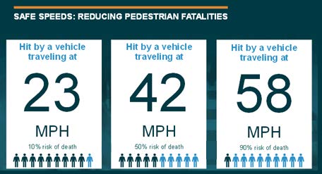
Source: FHWA based on AAA study1
Transportation practitioners use a variety of strategies to manage speed, and lowering speed limits citywide is one of those strategies. However, simply lowering the citywide speed limit isn't always enough to slow drivers—a wide travel lane design and unobstructed views on many city arterials encourage speeding by making drivers feel that it is safe to speed.
Redesigning City Arterials
Many cities incorporate countermeasures into street design to reduce vehicle speeds and contribute to a complete streets environment—one that enhances the safety and mobility of all road users. Examples include:
Raised Pedestrian Crosswalks

Source: SDOT, Rasied crosswalk, https://creativecommons.org/licenses/by-nc/2.0/
Often installed at mid-block crossings, raised pedestrian crosswalks extend across the entire width of the roadway. Pedestrians cross at the same level as the sidewalk, making them more visible to drivers. Approach ramps cue drivers to slow down, giving them more time to react near pedestrians.
Lane Reduction
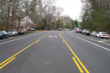
Source: FHWA
Lane reduction reduces the number of travel lanes on a multilane undivided roadway, which can affect a driver's choice of speed. Also known as a road diet, the extra space can be reallocated to add dedicated turn and bus lanes and other countermeasures such as pedestrian visibility and crosswalk enhancements.
Curb Extensions
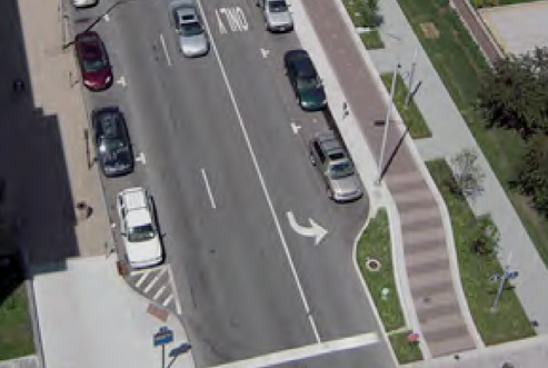
Source: FHWA
Curb extensions reduce the width of the roadway by extending the curb into the parking lane. This shortens pedestrian crossing distances and reduces the time needed to cross the street. Drivers are encouraged to slow down when approaching intersections and mid-block crossings, making turns, and traveling through intersections.
Lane Narrowing
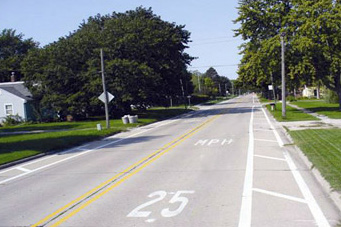
Source: FHWA
Lane narrowing using pavement marking techniques reduces the width of the travel lane. It frees up space for traffic calming measures such as widened sidewalks, extended curbs, and chicanes. Also called a lane diet, this can force slower vehicle traffic, make drivers more aware of surroundings, and give drivers more time to react to pedestrians at intersections and crosswalks.
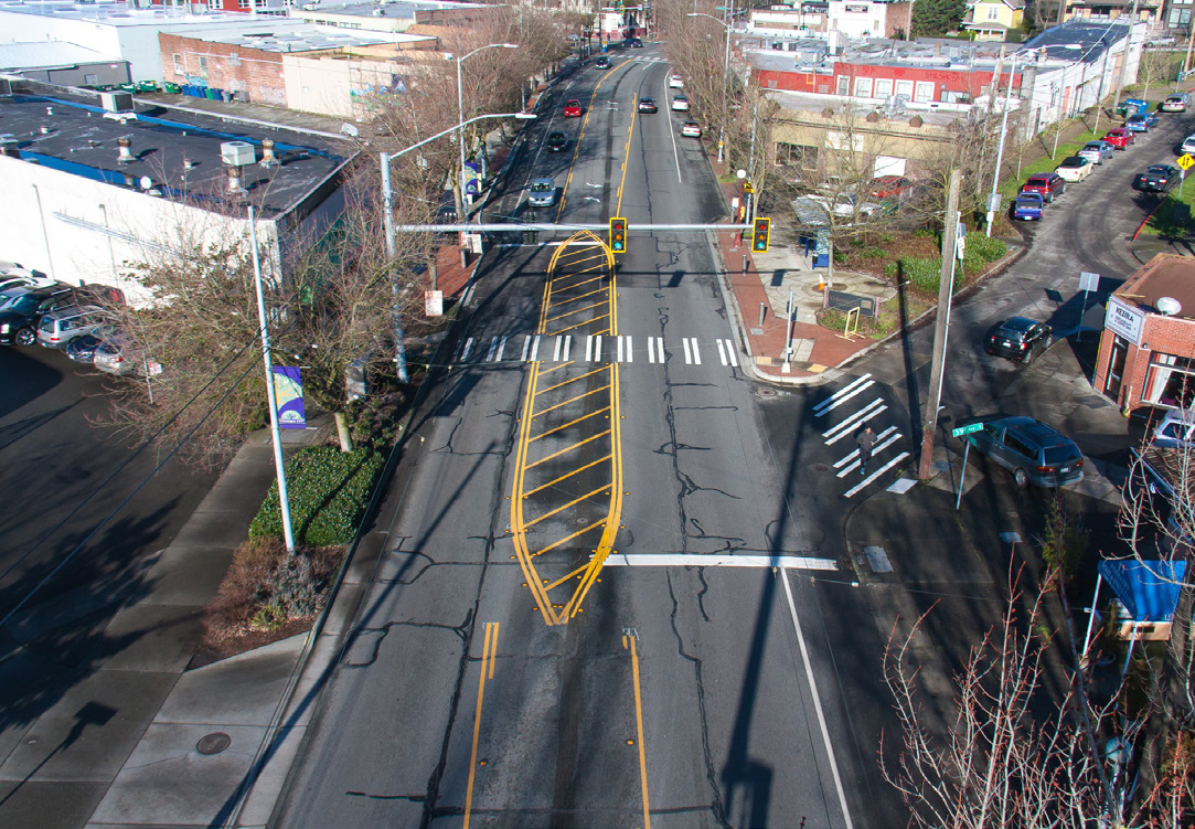
Spotlight on Seattle: Redesigning a Crash-Prone Arterial
After lowering the citywide speed limit from 30 to 25 mph, excessive speeding on Rainier Avenue South was still a challenge. Seattle Department of Transportation employed street design changes to help improve speed limit compliance and road user safety on Rainier Avenue South.
- Reduce excessive speeding
- Increase compliance with reduced citywide speed limit
- Reduce number and severity of injuries from collisions
- Removed one lane of traffic in each direction
- Added dedicated bus lanes and center turn lanes
- Narrowed travel lanes with curb and sidewalk extensions
- Improved signage for better visibility of lowered speed limit
- 52% decrease in speeding northbound; 28% decrease southbound
- 15% decrease in collisions overall
- 30% decrease in injury collisions
- 40% decrease in pedestrian and bicycle collisions
* Source: SDOT, Rainier Avenue South Safety Corridor: Rainier Pilot Project Evaluation.
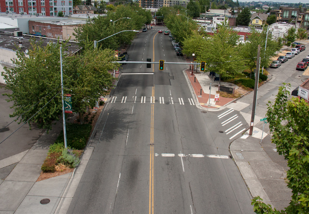
Before
After
Source: Seattle Department of Transportation
"Redesigning Rainier Ave S to be self-enforcing and adding speed management countermeasures has improved compliance with the lowered posted speed limits."
–Jame Le, SDOT
Learn More
- FHWA's Traffic Calming ePrimer
- USLIMITS2: Set reasonable, safe, and consistent speed limits for specific road segments
- Rainier Avenue Improvement Project
1 AAA Foundation for Traffic Safety, Impact Speed and a Pedestrian's Risk of Severe Injury or Death (Washington, DC: 2011). [ Return to note 1. ]