U.S. Department of Transportation
Federal Highway Administration
1200 New Jersey Avenue, SE
Washington, DC 20590
202-366-4000
Defining the affected environment in a project study area provides the foundation for developing and evaluating project alternatives, and identifying mitigation strategies. The existing condition of the affected environment is typically used as a baseline for comparison of any build alternative against the No-build alternative. Both quantitative and qualitative descriptions are desirable.
Examples include, but are not limited to, identifying the location, size, and quality of wetlands; describing and mapping significant historic and cultural properties; and mapping neighborhoods, towns, communities, schools, hospitals, businesses, and parks.
The existing condition of safety in the project area provides a baseline for comparison with the proposed improvements. This comparison is especially pertinent when safety is a primary reason for the project. Defining the context of the project also is important when considering the potential safety issues or impacts. The community context helps define the key safety concerns, the needs of special types of road users, and the safety solutions that are most appropriate. In addition, considering community character as part of project development is consistent with national best practices – specifically the concept of Context Sensitive Solutions (CSS).
The following are some examples of special types of project contexts that could influence the definition of safety issues and solutions.
Downtown areas tend to have high concentrations of bicyclists, pedestrians, and transit vehicles, and a high density of intersections. Parking locations also can have safety implications. Vehicles conflict with crossing pedestrians, and local buses attempting to reach transit stops may conflict with bicyclists. Balancing the safety and mobility needs of these users at intersections and along crowded streets, while balancing other community needs, is a key challenge. Designs that might be appropriate in rural or suburban areas, such as providing larger turning radii, widened shoulders, or removing trees near the roadside, may conflict with community desires to enhance walkability and livability. The FHWA-sponsored CSS web site provides resources on these topics: http://www.contextsensitivesolutions.org.
Complete Streets
Many jurisdictions and agencies are pursuing “complete streets” policies. These policies require agencies to design and operate roadway facilities to provide a basic level of safety and accommodation for all roadway users, including drivers, transit users, pedestrians, bicyclists, older people, children, and the disabled. This could mean, for example, requiring sidewalks on all newly constructed roadways; however, the exact requirements of complete streets policies vary by jurisdiction.
www.pedbikeimages.org/danburden
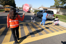
Children, elderly, and disabled people are more vulnerable than other groups to die if involved in a traffic crash. Give special consideration to the safety in areas with high concentrations of these populations, particularly at roadway crossings. Consider a mix of safety strategies, such as median refuges at roadway crossings, in-school educational programs focused on child safety, or heightened fines for speeding in school zones.
Specific outreach activities to support NEPA goals can be oriented toward these vulnerable groups, including school events, provided that they are well-integrated into the NEPA process and sufficiently documented. Special outreach to seniors should be undertaken as well, with “scoping”-like focus groups to discuss pedestrian activity patterns and ongoing discussion to discuss special needs and design considerations with seniors. Strong coordination with Safe Routes to School (SRTS) coordinators also is important to ensure effective stakeholder outreach.
The NCHRP 500 Volume 9, A Guide for Reducing Collisions Involving Older Drivers, and the web site of the FHWA-sponsored National Safe Routes to Schools Center may be helpful: http://www.saferoutesinfo.org/resources/?/publications.cfm.
A unique range of issues arise in safety around transit stations. In particular, transit stops are frequently the site of crossing pedestrians, and it is important to enhance their visibility to motorists, including transit bus drivers. Transit stop placement is an important consideration; at intersections, far-side stops are usually preferred for a variety of safety and operational reasons. One safety advantage is that pedestrians cross in back of the bus.
The web site of the FHWA-sponsored Pedestrian and Bicycle Information Center contains information on improving pedestrian safety around transit stations (http://www.walkinginfo.org/transit/access.cfm/).
Freight vehicles have special needs such as turning radii that will safely accommodate turning movements, truck rest stops that allow drivers to rest and reduce the risk of crash, and escape ramps in areas with steep grades. Give these users special consideration in areas with high volumes of freight vehicles. NCHRP 500 Volume 13: A Guide for Reducing Collisions Involving Heavy Trucks provides information improving safety for heavy trucks. Some proven countermeasures from this report include performing safety consultations with carrier safety management, and installing interactive truck rollover signing.
Rural roadways have higher crash rates than other types of roadways. Typical safety issues include nighttime visibility, impaired driving, speeding, animal crossings, fixed objects next to the roadway, sharp curves, and lack of a “clear zone” where drivers can safely stop if they run off the road. Visit the FHWA’s Local and Rural Road Safety web site for resources: http://safety.fhwa.dot.gov/local_rural/. The University of Minnesota’s Center for Excellence in Rural Road Safety is another important resource: http://www.ruralsafety.umn.edu/.
Any of the possible project contexts mentioned previously can be the site of a high number of crashes. These locations deserve special consideration, particularly if the analysis suggests that the number of crashes is higher than expected given the roadway type and volumes of vehicles and other roadway users. The HSM contains detailed information on identifying high-crash locations and addressing issues. These locations are identified as part of the Federal Highway Safety Improvement Program.
Table 7.1 summarizes some of the special characteristics and issues arising in these contexts.