U.S. Department of Transportation
Federal Highway Administration
1200 New Jersey Avenue, SE
Washington, DC 20590
202-366-4000
![]()
U.S. Department of Transportation
Federal Highway Administration
Summer 2023
Downloadable PDF [661 KB]
In this issue:
Vulnerable Road User Assessment Guidance
New in Pedestrian Safety Technology
FHWA and NHTSA Release Speed Safety Camera Guide
First Round of Safe Streets and Roads for All Grants Awarded
Source: FHWA
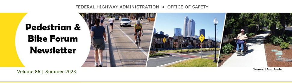
Study tour participants (left to right) Jonah Chiarenza, Lee Austin, Rachel Carpenter, Laura Sandt, Shari Shaftlein, Tamara Redmon, Mark Cole
Representatives from, the Federal Highway Administration (FHWA), State and local transportation agencies, and a university participated in a study tour under the FHWA Global Benchmarking Program (GBP). The GBP serves as a tool for accessing, evaluating, and implementing proven international practices to improve highway transportation in the U.S.
The purpose of this study was to examine noteworthy approaches and innovations used by other countries to achieve reductions in pedestrian serious injuries and fatalities on arterial roadways. The study team researched strategies from eleven peer countries in Europe, South America, and Australasia (Australia, New Zealand, and surrounding islands) that outperform the U.S. in pedestrian safety outcomes.
This research included a literature review and interviews with over 40 subject matter experts to identify the best candidates to inform U.S. approaches to improving pedestrian safety on urban, signalized arterials. Based on the findings, the study team developed an interim desk review, detailing the performance of each country, which can be viewed here. A webinar that discussed the desk review was held and the recording is online (passcode is 6&CJhs=2).
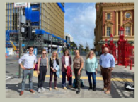
Based on the results of the interviews and literature review, the study team selected New Zealand and Australia for a week-long study tour to learn more about these countries' approach to improving pedestrian safety on their transportation networks, with a focus on arterial roadways. A full account of the study and findings are documented in a report, which will be available on the Office of International Programs website in the near future.
The team developed the following goals for implementing key findings and recommendations resulting from the study that will be undertaken over the next couple of years:
There are several goals related to research as well. For more information contact tamara.redmon@dot.gov.
Source: Laura Sandt
As mentioned in the last edition of this newsletter, the FHWA announced new guidance in October, 2022, to help States address the crisis of non-motorized roadway deaths across our nation as part of its ongoing efforts to prioritize safety and meet milestones laid out in the Bipartisan Infrastructure Law. States have until November 15, 2023 to develop their assessments.
FHWA held two webinars to provide further assistance. The first of these was held in November 2022 to provide an overview of the guidance and answer questions. A second webinar on was held on April 3, highlighting examples of potential Vulnerable Road User Assessment activities from agencies around the country.
Both webinars were recorded and the first one can be found here, and the second here.
FHWA is hosting bi-monthly Live Technical Assistance sessions where States can come to ask questions about VRU Safety Assessments and hear from their peers in other State DOT agencies. The first one was held on April 5. Please use this form to register for future Live Technical Assistance sessions.
In addition, FHWA can provide a limited amount of free technical assistance to those who may need it. Please fill out this form to request assistance. Contact tamara.redmon@dot.gov for more information.
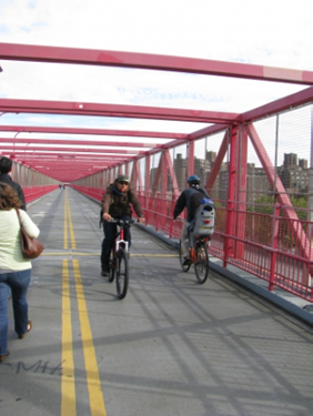
Source: Dan Burden
The National Highway Traffic Safety Administration’s (NHTSA) Partnership for Analytics Research in Traffic Safety published the report, Real-world Effectiveness of Model Year 2015-2020 Advanced Driver Assistance Systems.
Advanced driver assistance systems (ADAS) in motor vehicles reduce traffic crashes and save thousands of lives on roadways each year. Pedestrian Automatic Emergency Braking (PAEB) is an ADAS for detecting and avoiding pedestrians. The authors suggest more research is needed to understand PAEB effectiveness, including the contribution of lighting and infrastructure on driver and pedestrian behaviors.
The U.S. Department of Transportation's (U.S. DOT) top priority is safety. The U.S. DOT National Roadway Safety Strategy outlines the Safe System Approach as the guiding paradigm to reduce serious injuries and deaths on our Nation’s highways, roads, and streets. Intelligent transportation systems (ITS) can support these objectives and help in reaching the goal of zero roadway fatalities.
The Joint Program Office’s (JPO) ITS Deployment Evaluation Program has developed the Spotlight on ITS for Roadway Safety web pages, containing a variety of evaluation products organized by safety category to support informed decision-making. Current topics include pedestrian safety, work zone safety, and roadway safety, with more topics on the way.

FHWA and NHTSA’s new Speed Safety Camera Program Planning and Operations Guide replaces the “Speed Enforcement Camera Systems Operational Guidelines,” published in 2008. This update emphasizes speed safety cameras (previously known as automated speed enforcement, photo enforcement or photo radar) as a component of a comprehensive speed management program, integrating equity and transparency throughout program planning, operations, and evaluation.
Speeding is one of the most common factors in motor vehicle crashes in the United States. In their 2021-2023 Most-Wanted List of Transportation Safety Improvements, the National Transportation Safety Board included a recommendation for FHWA and NHTSA to update guidance on speed safety cameras as part of a comprehensive strategy to eliminate speeding-related crashes. In alignment with the Safe System Approach, achieving safe speeds is a key focus of the USDOT’s National Roadway Safety Strategy (NRSS), and promoting speed safety cameras as a FHWA proven safety countermeasure is an action highlighted in the NRSS.
Speed safety cameras can be an effective tool to protect vulnerable populations in many areas, including in school zones and work zones. The cameras have been shown to reduce crashes up to 54 percent in various applications using fixed, mobile, or point to point applications. New York City found the use of fixed units in school zones reduced speeding up to 63 percent during school hours.
If you have any questions pertaining to the speed safety cameras, please contact Jeff King.
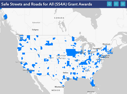
Source: U.S. DOT
Round 1 (FY2022) of the Safe Streets and Roads for All (SS4A) Grants was announced in February. More than $800 million in funding specifically and entirely dedicated to safety is going out to fund projects and safety action plans-a record amount of funding to improve roads and address traffic fatalities.
The competitive grant program, established by President Biden’s historic infrastructure law, provides $5 billion over five years for regional, local, and Tribal initiatives - from redesigned roads to better sidewalks and crosswalks - to prevent deaths and serious injuries on the nation’s roadways. The Department also launched a data visualization tool that shows crash hotspots that can help target needed resources. The full list of awards can be found here. The next Safe Streets and Roads for All FY23 NOFO Is Open and the deadline for applications is 5:00 p.m. (EDT) Monday, July 10, 2023. Late applications will not be accepted. For details, more information, and applicant guidance, visit the SS4A web page.
My Street is a pedestrian safety planning tool that integrates data from the Federal Highway Administration Highway Performance Monitoring System and the U.S. Census Bureau TIGER lines and American Community Survey to produce pedestrian crash risk maps and statistics for local communities. It intended for small to medium sized cities and MPOs, and agencies have to request access and also have to provide geo-located pedestrian crash data.
The tool allows users to explore options for improving pedestrian safety based on user-provided data or data already incorporated in the tool. Once the area is identified, My Street conducts a systemic analysis and identifies priority sites for consideration, illustrates potential pedestrian crossing countermeasure options, and shows how site-level countermeasures impact pedestrians in that community. The tool uses pedestrian avatars to show how different decisions impact pedestrians. The final output is a sharable Pedestrian Safety Action Plan report based on the inputs. A user guide is available for download. Contact Becky Crowe for more information.
The nighttime fatality rate on the Nation’s roadways is three times higher than the daytime rate, and 76 percent of pedestrian fatalities occur at night. Enhancing nighttime visibility where non-motorists mix with traffic during darkness will save lives. The focus is to improve nighttime visibility by deploying countermeasures at high conflict locations such as schools, transit centers and urban cores to safely connect people to the community and essential services.
FHWA has used a focused approach to safety for many years, based on findings that almost 90 percent of the traffic fatalities in the United States happen in three main areas: Intersections, Pedestrians and bicyclists, Roadway departures.
Intersections. Nighttime crashes at rural and urban intersections can be reduced by 33 to 38 percent using well designed lighting. Adequate intersection lighting can help reduce nighttime pedestrian-injury crashes by 42 percent. In addition, light-emitting diode (LED) luminaires use less energy than tradition- al ones, like high-pressure sodium luminaires, creating cost savings.
Pedestrians and Bicyclists. Crosswalk visibility enhancements for pedestrians such as rectangular rapid flashing beacons (47-percent reduction) or advance markings and signs (25-percent reduction) make it safer for people to cross a road. Many of these countermeasures are also cost-effective and relatively easy to install.
Roadway Departures. Horizontal curve delineation enhancements using chevrons (16- to 25-percent reduction), in-lane pavement markings (35- to 38-percent reduction), or fluorescent sheeting (18-percent reduction) can alert drivers to upcoming curves and can be used individually or in combination with each other or other countermeasures to reduce fatalities.
Nighttime Visibility for Safety Website
FHWA Nighttime Visibility General Information
FHWA Proven Safety Countermeasures
FHWA Intersection Safety
FHWA Focus on Reducing Rural Road-way Departures (FoRRRwD) Website
FHWA Safe Transportation for Every Pedestrian (STEP) Website
Lighting-A Florida Case Study on a Proven Safety Countermeasure (video)
Pedestrian Lighting Primer
Joseph Cheung
(202) 366-6994
Joseph.Cheung@dot.gov
Victoria (Tori) Brinkly
(360) 833-3795
Victoria.Brinkly@dot.gov
George Merritt
(404) 895-0250
George.Merritt@dot.gov

This Pedestrian and Bike Forum is available on the Web at http://safety.fhwa.dot.gov/ped_bike/pedforum/
To receive information on future newsletters, please use the e-subscription service provided on this site: https://public.govdelivery.com/accounts/ USDOTFHWA/subscriber/new?topic_id=USDOTFHWA_102
Scroll down to “Pedestrian and Bicycle Safety” and select “subscribe” next to “Pedestrian Forum.”
Tamara Redmon,
Pedestrian and Bicyclist Safety Program Manager Federal Highway Administration
1200 New Jersey Avenue SE, Room E71-303 Washington, DC 20590
Phone: 202-366-4077 | E-mail: tamara.redmon@dot.gov

