U.S. Department of Transportation
Federal Highway Administration
1200 New Jersey Avenue, SE
Washington, DC 20590
202-366-4000
| < Previous | Table of Content | Next > |
This report presents the methods and key findings from the Miami-Dade comprehensive pedestrian safety planning and engineering project. It is one of three such projects in the nation funded by the Federal Highway Administration (FHWA) to evaluate:
In Phase I: The effectiveness of a pedestrian safety plan to target higher-injury areas;
In Phase II: The implementation of a range of mostly low-to-moderate-cost, innovative engineering safety improvements.
This report concentrates on the Phase II countermeasure implementation efforts, minimizing duplication with earlier reports, and focusing primarily on the implementation experience and overall lessons learned.
This project had three primary goals:
1.) The installation of pedestrian countermeasures;
2.) The scientific evaluation of the countermeasures in order to determine their efficacy; and
3.) To produce a significant crash reduction along the treated high crash corridors.
The University of Florida, Department of Civil and Coastal Engineering and Miami- Dade County Department of Public Works proposed and conducted the project from planning through implementation. A separate Phase I (Planning) Final Report, finalized Dec 5, 2002, covered:
Problem Identification: a comprehensive picture of pedestrian injury collisions in high crash corridors in Miami-Dade County.
Countermeasure Selection Plan: a conceptual blueprint, describing proposed countermeasures for Pedestrian Safety implementation, and descriptions of countermeasures selected for inclusion in the Pedestrian Safety study.
Evaluation Plan: a conceptual plan for assessing the impacts of the countermeasures.
Outreach and Awareness Plan: a conceptual plan for educating the public about countermeasures to be implemented, in addition to promoting safer driver and pedestrian behavior.
The June 25, 2004 Phase II Research Implementation Plan clarified the countermeasure plan, including cost estimates and, where appropriate, conceptual layout plans. It also presented refined outreach and data collection/evaluation plans. Due to engineering and institutional challenges, some of the proposed countermeasures could not be implemented while additional countermeasures were added. These challenges are described in this report.
This section of the executive summary provides a brief overview of the presentation in the Phase 1 Report, which is not repeated in the main portion of this report. This section has been added to the executive summary to give the reader perspective on the nature of the crash problem in Miami-Dade County, how treatment corridors were selected, and how countermeasures were selected and matched to each selected corridor. Miami-Dade had a population of 2,253,362 in 2000, which is about 14 percent of Florida’s total population. The population is diverse and predominantly Hispanic (57.3 percent). The per capita pedestrian fatality and injury crash rates are very high. Among the 82 pedestrian deaths in 1999, nearly half involved pedestrians age 55 or older. Total injuries are greatest in number for ages 25 through 54. African Americans are over- represented in terms of population with a crash rate approximately 50 percent higher than their proportion of the population, and Hispanic Americans are under represented with a rate less than half their proportion of the population. Alcohol use in pedestrian fatalities is under-represented in Miami-Dade at only 16.8 percent, compared to 35 percent statewide.
A little more than half of the pedestrian crashes in Miami-Dade County occurred on state or county roads, while 46 percent of the remaining crashes occurred on local roads. Because there are many more miles of local roads than state or county roads, the pedestrian crash rate per mile is much higher for this type of roadway. The number of pedestrian fatalities was approximately equal for local, state and county roads reflecting a much higher fatal crash rate per mile for state and county roads. In regard to lighting conditions, children and seniors are more likely to be struck in daylight than pedestrians of other ages, and pedestrians age 18 to 24 have the highest incidence of nighttime collisions.
The major pedestrian safety effort completed outside of the pedestrians safety project was a National Highway Traffic Safety Administration (NHTSA) project that focused on enforcement in Miami Beach and city wide public education aimed at drivers and pedestrians (Zegeer et. al, 2008). The NHTSA project was implemented between 2002 and 2004. The Engineering components of the FHWA project were installed in 2005 and 2006. This presence of the NHTSA effort provided an excellent opportunity to determine the effects of engineering treatments added to city and community wide outreach and education efforts.
The NHTSA effort included the following components:
Pedestrian safety message mounted in bus and Metrorail train posters;
Public awareness announcements about pedestrian safety broadcasted on city and county access channels in Spanish and English and on selected Spanish speaking radio stations;
Walk Safely pedestrian brochures distributed to the Miami-Dade School Board, hospital and medical department, public library, police departments and elected officials’ offices;
Pedestrian safety workshops for older pedestrians.
Walking Through the Years: Pedestrian Safety for Older Adults. Booklets were delivered to organizations such as the Miami-Dade school Board, hospital and medical departments, retirement homes, public libraries (similar materials were distributed in Spanish);
Pedestrian enforcement of driver yielding behavior during 2002. Police stopped 2006 drivers for failing to yield to pedestrians.
Miami-Dade County has the highest incidence of pedestrian injuries and fatalities in the State of Florida, which ranked within the top two states in number of pedestrian crashes as well as per capita pedestrian crashes during the baseline period. In recent years the pedestrian crash rate had remained relatively steady prior to the implementation of the NHTSA and FHWA Pedestrian projects. During the nine years prior to the FHWA project there were a total of 15,472 pedestrian crashes in the DHSMV Miami-Dade County, which included 670 fatal crashes (4.2 percent). Figure 1.1 shows the geographic distribution of pedestrian crashes during the baseline period as a crash density map. High crash zones are represented by darker colors. Figure 1.2 shows the Crash map for South Miami Beach. South Miami Beach has the highest crash density in Miami-Dade County.
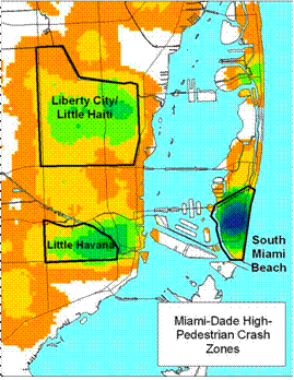
Figure 1.1 Miami-Dade High Pedestrian Crash Zones
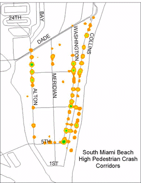
Figure 1.2 South Beach High Pedestrian Crash Corridors
The Phase 1 planning analysis and recommendations were developed in 2002 and the plan was revised in 2004. A zonal approach was employed to identify crash corridors with dense clustering of serious pedestrian crashes. Crash data over a five-year period were first mapped using GIS software to determine high crash corridors that were associated with the majority of serious crashes. The following process was followed to identify these high crash corridors. First, pedestrian crash data were extracted from Florida DMV records. Second, these crashes were entered into a GIS database and plotted. Third, crashes were weighted for severity and a crash index assigned. Fourth, the Pedestrian and Bicycle Crash Analysis Tool (PBCAT) was applied to all crashes and these data were merged back onto the GIS database. Fifth, the research team including an FDOT and Miami-Dade County representative visited each high crash corridor identified in steps one through four with a spreadsheet in hand documenting all pedestrian crash activity in that zone to examine local features contributing to crashes. Sixth, data were desegregated for specific aspects of the crash. Seventh, surrogate data were recorded or crash reports were studied where required to resolve ambiguities.
The outreach plan proposed integrating selected countermeasure and outreach and awareness into ongoing efforts, as well as working with agencies responsible for pedestrian safety (e.g., Police and Public Health departments) and working with grassroots community groups committed to pedestrian safety projects. For the most part, pedestrians did not need education about countermeasures because their meaning was intuitively clear (e.g., countdown signals and push buttons that confirm a button press). The media plan employed in Miami-Dade County involved a continuation of the NHTSA campaign described above through the office of the Pedestrian Bicycle Coordinator.
A two-day site visit in 2003 by FHWA staff and consultants included a detailed review of the initial countermeasure plan. In 2004 the project team fine tuned the work plan and proceeded into Phase II implementation. Extensive engineering efforts began in early in 2005 and continued into 2006. An Implementation Plan and Preliminary Engineering Report provided a detailed blueprint for conducting Phase II. The actual implementation was predominantly consistent with the Phase I report and the Phase II implementation plans, although some modifications were made in response to practical difficulties or changing exigencies.
A total of fifteen countermeasures (nine general engineering countermeasures and six intelligent transportation systems [ITS] countermeasures) were implemented by the University of Florida team during this Phase II investigation:
GENERAL ENGINEERING COUNTERMEASURES
Reducing the minimum green time at mid-block crosswalks controlled by a traffic signal.
Advance yield markings at crosswalks with an uncontrolled approach.
Recessed or offset stop lines for intersections with traffic signals.
Leading pedestrian intervals (LPI)
Pedestrian push buttons that confirm press
“Turning Vehicles Yield to Pedestrians” symbol signs for drivers
Eliminate permissive left turns at a signalized intersection.
In-street pedestrian signs
Pedestrian zone signs
Midblock traffic signal
INTELLIGENT TRANSPORTATION SYSTEMS (ITS) COUNTERMEASURES
ITS video pedestrian detection
Rectangular LED rapid flash beacons for uncontrolled multilane crosswalks
ITS smart lighting at crosswalks with nighttime crashes
ITS "No Right Turn on Red" (NRTOR) Signs
Pedestrian countdown timers
Speed trailers.
In addition, an outreach program was implemented by Miami-Dade County through the office of the pedestrian bicycle coordinator. This outreach effort included distribution of a video public service announcement (PSA) to cable and small/ethnic local TV stations, and presentations at schools and senior centers. It was not possible to evaluate each of the outreach efforts separately.
The overall cost of this project was slightly greater than $1,000,000 dollars, including $870,540 in federal funding, $140,000 in state funding, and $186,771 in county funding. The federal funding averaged roughly $ 217,635 per year.
The total costs of the nearly seven-year-long project included the following estimated cost breakdown:
PLANNING PHASE I: $125,000
IMPLEMENTATION PHASE II: $1,010,540
Including:
Design of Countermeasures: $133,933
Installation/Deployment Labor: $108,833
Materials and Equipment: $302,913
Data Collection & Evaluation: $282,172
Other Program Management $182,690
(Including planning and design of countermeasures not installed)
In general, the labor costs exceeded the equipment and materials costs. Overall, the engineering/administrative costs were quite substantial, largely due to the need for specialized training, mobilization, and approvals for new devices. These engineering/administrative costs often exceeded the material/equipment costs and the installation labor.
The least expensive countermeasures in total per-unit costs were Pedestrian Warning Signs. The most expensive countermeasure was the Video Detection System.
All but two countermeasures were compliant with the Manual of Uniform Traffic Control Devices. The rectangular rapid flash beacon and the “turning vehicles yield to pedestrians” symbol signs were granted FHWA permission to experiment. Several of the treatments that were considered experimental when initially proposed by the University of Florida team were added to the MUTCD in the 2003 revision.
Countermeasures that required the least effort to install were:
Countdown Pedestrian Signals. The original incandescent signals were simply changed out.
Pedestrian push buttons that confirmed the button press. These were easily swapped for the standard push button.
Advance Stop/Yield Lines. These were easily installed along the corridor with new pavement. They were no more difficult to install than lines at the minimum distance. Moving stop lines involve greater cost because the old markings need to be removed by grinding.
Reducing Minimum Green Time at midblock traffic signals. These only required timing changes in the traffic signals computer.
Leading Pedestrian Interval. These only required timing changes in the traffic computer.
Countermeasures that required a moderate effort to install were:
“Turning Vehicles Yield to Pedestrians” Symbol Signs. These signs needed to be mounted on the mast arm.
In-Street “Yield to Pedestrians” Signs. These signs needed to be installed in the roadway and had to be frequently replaced.
Rectangular LED Rapid Flashing Beacons. These signs communicated by RF transmitters and were powered by a solar array. Therefore they required no wiring.
ITS Smart Lighting. This treatment was part of the Rectangular LED Rapid Flashing Beacon treatment.
Speed Trailer. The major issue with speed trailers is labor associated with attending to the trailer. Newer solar power speed signs that can be affixed to poles would be easier to install.
ITS “No Right Turn on Red” Signals. These signs required installation on the mast arm.
Countermeasures that required the most effort to install were:
Eliminate Permissive Left Turns at Signals. This treatment required replacing the traffic signal array.
ITS Video Pedestrian Detection. This treatment required installation and adjustments to get it to work correctly.
Installation of a midblock signal. This is a relative high cost item including mast arm and wiring. Originally installed to evaluate midblock animated eyes display later converted to a short minimum green midblock installation.
Several devices originally proposed in the Phase II work plan were not implemented for the reasons provided below.
The animated eyes countdown signals were not installed as originally planned, because the vendor, Relume, lost interest in supporting experimentation with the device, apparently after assessing the market potential for the devices. Ordinary Countdown timers were installed in their place.
The midblock crossing with animated eyes display showing the direction the pedestrian was crossing was not installed because research carried out under FHWA permission to experiment in St. Petersburg, Florida found the rectangular LED rapid flashing beacon to be more effective. The rectangular LED rapid flashing beacon was subsequently added to the implementation plan and the original midblock crossing proposed for installation of the animated eyes display was converted to a standard midblock traffic signal.
The most important measure was data on crashes because these best validated the safety value of the countermeasures installed. However, because multiple treatments were installed in all corridors it was impossible to attribute the crash reductions to any particular countermeasure. We originally planned on employing a mix of video recording and field observation to record surrogate measures. Unfortunately the video recording systems were destroyed by a major hurricane. This forced the team to substitute field observation for video recording to assess the effects of each treatment on surrogate measure at all of our sites. The shift from video to live data recording required the team to reduce the number of items scored from those originally proposed because field observation does not allow multiple viewing of events (a necessary condition to reliably score many aspects of a single event).
The pedestrian/driver observations employed a mixture of design features. Some experiments were simple before and after installation evaluations. In other cases, multiple baseline (staged introduction of the treatment at different sites to control for extraneous variables) and follow-up observations were conducted to ascertain the effects of the passage of time and novelty fading. In a few cases treatments were introduced, removed and reintroduced using replication logic to rule out the effects of uncontrolled variables. Statistical tests were employed (generally z-tests and t-tests) to test for difference of proportions/means.
Following is a summary of results obtained for each countermeasure. This table indicates the purpose for installing each countermeasure, highlighted results, and a ranking of relative cost. Results are only reported in this table if they are statistically significant (p<0.05).
| COUNTERMEASURE | PURPOSE | OBSERVATION HIGHLIGHTS | RELATIVE COST |
|---|---|---|---|
| Push buttons that confirm press | To Confirm press so pedestrian waits for WALK | The percentage of cycles that a pedestrian pressed the button increased from 33.8% to 58.1% at the first site and from 40.3% to 54.3% at the second site. The percentage of pedestrians who pressed the button that waited for the “WALK” increased from 51.2% to 72.5% at the first site and from 72.3% to 86% at the second site. | Low Cost |
| Reduce Minimum Green Time | To reduce pedestrian wait time to increase pedestrian compliance | Reducing minimum green time reduced pedestrian wait time and significantly increased pedestrian compliance. At one site reducing minimum green time improved pedestrian compliance from 64% to 98%. Vehicle delay also increased |
Low Cost |
| Video Pedestrian Detection | To place calls for pedestrian that don't press the call button | The device was reliable but many pedestrians did not wait even when the device placed the call for them. This treatment needs to be used in conjunction with reduced minimum green time | High Cost |
| Lead Pedestrian Phase | To provide a head start for pedestrians. When RTOR is permitted, the maximum effect is obtained with left turning vehicles | This treatment produced an increased yielding by drivers of left turning vehicles | Low Cost |
| “Turning Vehicle Yield to Pedestrians" symbol sign | To increase yielding by drivers of turning vehicles | Mixed results. This sign was not superior to the text only sign | Moderate Cost |
| Electronic NRTOR sign | To restrict right turns on red during the WALK and yellow phase | This sign statistically significantly reduced violations as compared to the static sign and produced a marked decrease in the percentage of drivers turning ROR who made no stop from 40% to coming to 13%. | Moderate Cost |
| Countdown Pedestrian Signals | Provides information to pedestrian on the time remaining to cross | The installation of the countdown timers was associated with a statistically significant increase in the percentage of pedestrians that pressed the call button | Low Cost |
| In-Street "Yield to Pedestrian Signs" | This sign marks crosswalks and reminds drivers of their obligation to yield right-of-way to pedestrians in crosswalks | These signs increased the percentage of drivers yielding right-of-way to pedestrians from 19% to 71% but they were easily damaged | Moderate Cost |
| Pedestrian Zone Signs | To warn drivers to expect pedestrians in the roadway | This sign had no effect on driver speed | Low Cost |
| Speed Trailers | To alert drivers to slow down | The speed trailer increased braking for pedestrians but had no effect on speed which was already within the speed limit | Moderate Cost |
| Rectangular LED Rapid Flashing Beacons | Alerts drivers that a pedestrian is in the crosswalk | This sign increased the percentage of drivers yielding to pedestrians from 0% to 65% at one site and from 1% to 92% at the second site. Both test sites were high-speed multilane roads. | Moderate Cost |
| Dynamic Lighting | Alerts driver that a pedestrian is crossing and makes the pedestrian more visible | This device was used with the rectangular LED beacon. It was not effective but the level of illumination was not very great | Moderate Cost |
| Eliminate Permissive Left Turn | Reduces conflicts between left turning vehicles and pedestrians | This treatment reduced conflicts between left turning vehicles and pedestrians | High Cost |
| Advance Yield Markings | This treatment can increase the visibility of pedestrians in crosswalks | The wrong size sign was specified in the 2003 MUTCD NOT EVALUATED IN THIS STUDY |
Low Cost |
| Offset Stop Lines | This treatment can increase the visibility of pedestrians in crosswalks | NOT EVALUATED IN THIS STUDY | Low Cost |
The introduction of the NHTSA project was associated with a modest reduction in crashes. Adding the engineering countermeasure produced a further reduction in crashes at all sites. Following is a summary table showing the mean number of crashes per year at each treated site and for all treated sites combined during each condition of the study.
| SITE | BASELINE PERIOD CRASHES PER YEAR | NHTSA STUDY PERIOD CRASHES PER YEAR | FHWA STUDY PERIOD CRASHES PER YEAR |
|---|---|---|---|
| All sites combined | 101 | 87 | 51 |
| Alton Road: (5th St. to 17th St.) | 13.8 | 10 | 8.5 |
| 5 St: (Alton Rd. to Ocean Dr.) | 6.5 | 4.6 | 4 |
| Collins Ave: (5th St. to 24th St.) | 18.8 | 20 | 13 |
| 41 St: (Alton Rd to Pine Tree Dr.) | 7 | 5.3 | 2 |
| Collins Ave & Harding Av | 14.3 | 13 | 9.5 |
| NE 6th Ave. (NE 141 St. to NE 151 St.) | 7.7 | 8 | 3 |
| NE 163 St. (NW Ave. to Biscayne Blvd) | 25.8 | 20.7 | 8 |
All of the traffic control devices deployed in this study were intuitive in nature and required little outreach and awareness training. Countdown pedestrian signals, offset stop lines, push buttons that confirm the button press, automatic pedestrian detectors (passive in nature), a leading pedestrian phase, "Turning Vehicles Yield to Pedestrian" signs, in roadway signs, elimination of permissive left turns, dynamic NTOR signs, the rectangular LED rapid flashing beacon, dynamic lighting (passive in nature), pedestrian zone warning signs, shorter minimum green waiting times, and advance yield markings are familiar to motorists and pedestrians. Therefore outreach and awareness focused on continued enforcement along with a continuation of the educational countermeasures deployed as part of the National Highway Traffic Safety Administration (NHSTA) Miami-Dade Contract that begun prior to the FHWA Cooperative Agreement.
In terms of the project goals the project was successful. Many treatments were implemented in the high crash areas. Miami-Dade County was impressed with some of the countermeasures and is presently in the process of deploying more of them in other areas. Some examples are countdown pedestrian signals and rectangular LED rapid flashing beacons. We also were successful in learning a good deal about some of the countermeasures including how to use them most effectively. We have published four papers in Transportation Research Record on our findings to date. More papers will be submitted this year. We also obtained a statistically significant reduction in crashes at the treatment sites.
The GIS crash mapping tools were particularly useful and were further enhanced by the MPO adding demographic information to the field, such as ages, PBCAT information, driver ages, time of day, weather conditions, etc. Sorting this information by site and printing it in booklet form made this information immediately available during site visits. However, there were times when only the crash reports could sort out the nature of a particular problem. The crash diagram was one of the most useful components of the crash report in determining the type of crash. On the other hand, the PBCAT tool that was available during baseline assessment had several limitations that reduced its utility. In order of usefulness, the enhanced GIS crash maps were the most useful tool, followed by site visits conducted with the booklet that sorted crashes by sites and listed all of the information added to the GIS database, followed by the crash reports. It is hoped that the most recent version of PBCAT will prove more useful to practitioners wishing to match countermeasures to crash sites.
There is a good deal of coordination required to make a large project successful. One problem we had not anticipated was extreme weather. Miami-Dade County was struck by two major hurricanes while we were assessing the treatments we installed. The storms destroyed camera placement sites, requiring us to shift to field observers for some of our evaluations. Storm damage also required us to reinstall some treatment installations, and the extent of damage tied up contractors for long periods of time, resulting in delays in installing some of the equipment we needed to make evaluations. At other times other priorities, such as changing the signage for all school crossings in Miami-Dade County, resulted in delays in implementing particular countermeasures.
Anther issue was the sheer scope of such a project. Agencies wishing to implement engineering countermeasures along high crash corridors might wish to prioritize the zones identified in their initial analysis and determine and implement treatments one zone at a time. This would allow better coordination and use of resources without overburdening administration and infrastructure. It would also allow the agency to assemble the contracting resources to implement the project more easily.
One positive feature was the excellent level of cooperation from Miami-Dade County and the Florida Department of Transportation District Office. The professionals from these organizations provided constructive suggestions and did not present barriers to innovation. We also received excellent cooperation from the Miami-Dade Metropolitan Planning Organization. The bicycle pedestrian coordinator and the signals design engineer were particularly helpful in assisting the team with its mandate.
| < Previous | Table of Content | Next > |

