U.S. Department of Transportation
Federal Highway Administration
1200 New Jersey Avenue, SE
Washington, DC 20590
202-366-4000
![]()
| < Previous | Table of Content | Next > |
| Project: improvements to two-lane rural highway in a constrained area | |||
|---|---|---|---|
| Planned Improvements: |
|
||
| Project Environment: | urban | suburban | x rural |
| Project Design Stage: | x conceptual (0 to 30%) | preliminary (40 to 80%) | advanced (over 80%) |
| Project Cost: | < $100,000 | $100,000 - $1,000,000 | x >$1,000,000 |
| Project Owner: | Oregan Department of Transportation | ||
| Road Safety Audit | |||
| Date of RSA: | 11-13 April 2006 | ||
| RSA Stage(s): | x design stage | RSA of existing roads | |
| RSA team: | staff from Federal Highway Administration (including Office of Safety, Resource Center, and Oregon Field Office), Oregon DOT, VHB, and Opus Hamilton Consultants | ||
PROJECT BACKGROUND:
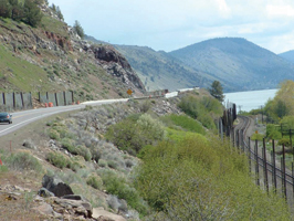
FIGURE A.4 RSA SEGMENT OF US 97
The project, along US Highway 97 between Modoc Point and Algoma, was located in Klamath County in South Central Oregon. In this area, the US 97 alignment passes along the east side of Upper Klamath Lake and the Union Pacific Railroad (FIGURE A.4). The Oregon Department of Transportation (ODOT) identified several safety issues along this section of US 97, including a fatality rate of 5.3 per million vehicle miles, almost double the average rate for similar Oregon highways. The DOT noted the presence of narrow substandard shoulders widths, substandard cut and fill slopes, and unprotected safety issues within clear the zone, including barriers, guardrail, and guardrail end terminals that did not meet current standards.
To address these and other concerns, a two-phase road improvement program was adopted by ODOT. Phase One work, which began in early 2005 and was in progress at the time of the RSA, included replacement/repair of four bridges as well as rockfall work and widening on the east side of the highway. Phase Two work, which was to be let in September 2007 with a projected completion date of November 2009, was expected to take place on the west side of US 97, between the highway and the adjacent railroad tracks.
The improvement projects were subject to several conditions that imposed unique and substantial constraints on design and construction:
This RSA incorporated the use of the Interactive Highway Safety Design Model (IHSDM), a suite of software analysis tools3 being developed by the FHWA to provide an explicit, quantitative evaluation of safety and operational effects of geometric design on two-lane rural highways. IHSDM was used to evaluate the elements of the existing and proposed design against design policy values, design consistency, and to predict the expected safety of the future road. IHSDM may be downloaded free of charge at http://www.ihsdm.org.
KEY RSA FINDINGS AND SUGGESTIONS:
The key findings and suggestions of the RSA are summarized in TABLE A.3.
| SAFETY ISSUE (Number and Description) |
Risk Rating | Suggestions | |
|---|---|---|---|
| 1 | Roadside safety issues included:
|
D |
|
| 2 | Sight distance was constrained by roadside topography, rockfall fences, and bridge superstructures at horizontal curves and at intersections. | C |
|
| 3 | Limited night-time guidance was provided on a curved alignment with hazardous side slopes. An enhanced level of delineation would be beneficial along this hazardous segment of roadway. | B |
|
| 4 | Signing issues included possible re-use of faded signs, missing intersection warning signs, and use of small lettering on street name signs. | B |
|
| 5 | Rockfall protection formed an important part of the design requirements. The very challenging improvement site may be a candidate for the use of enhanced rockfall protection measures. | B |
|
| 6 | High speeds contributed to increased collision risk and severity. | C |
|
| 7 | Winter weather: A high proportion of crashes occurred under winter road conditions. | C |
|
KEY LESSONS LEARNED:
The Interactive Highway Safety Design Model (IHSDM)is a useful tool toquantify safety issues associated with the audited design.
This RSA usedIHSDM to evaluate design consistency, compliance withselected design policy values,and to predict the expected safety of the future roadway. Specifically, theproposedalignment was analyzed using:
The ability to quantify values associated with design issues such as stopping sight distance, and to estimate futurecrash frequencies based onthe road re-design, enhanced thevalue of the RSAby demonstrating themagnitude ofthe safety issues identified by the RSA team. Without IHSDM estimates, the RSA team could identify, but could not necessarily quantify, expected changes in safety parameters such as operating speeds or in expected crash frequencies. Quantifyingthese parameters and frequencies provided a higher level of confidence to all parties (the RSA team, Design Team, and Owner) concerning the magnitude and importance of the safety issues identified in the RSA.
See also the discussion of “Key Factors for Success” and “Lessons Learned” in the main text.
3IHSDM currently includes five evaluation modules: Crash Prediction Module (CPM), Design Consistency Module (DCM), Intersection Review Module (IRM), Policy Review Module (PRM), and Traffic Analysis Module (TAM).
| < Previous | Table of Content | Next > |

