


Informational Guide for State, Tribal, and Local Safety Data Integration
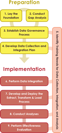
The Informational Guide is a result of developing case studies of successful data integration practices in four States and pilot studies implementing the guide with volunteer agencies. The Guide provides detailed descriptions of the nine steps of safety data integration and includes lessons learned and noteworthy practices.
![]()
Case Studies
Michigan Roadsoft – Integration of State and Local Safety Data Case Study
The program provides roadway asset management, field data collection, maintenance management, and safety analysis tools to local agencies. Each local agency maintains its own data in a local copy of Roadsoft and shares that information with the State upon request.
Ohio Location Based Response System – Integration of State and Local Safety Data Case Study
The program provides consistent location referencing for all public roadways. ODOT maintains the statewide roadway inventory database and integrates data owned and supplied by the local agencies.
Tennessee Roadway Information System – Integration of State and Local Safety Data Case Study
This case study outlines a centralized, State-led data collection effort for safety data and analysis. The Tennessee Roadway Information Management System (TRIMS) is a single integrated system that includes State and local roadways, structures, pavement, traffic, photo logs, and crash data.
Wisconsin Information System for Local Roads – Integration of State and Local Safety Data Case Study
This program results in an all-public-roads database using a single LRS and basemap. Local agencies collect and own the data, but the centralized system is available to all authorized users.
Pilot Studies
- Arizona DOT: The purpose of this pilot study was to provide the State of Arizona and selected local partner agencies with expert assistance in establishing shared data resources by integrating local data into a statewide database managed by ADOT. In addition, this project assisted with the programmatic extraction, transfer, and loading of data to enable advanced safety analyses.
- Navajo DOT: The purpose of this project was to provide the Navajo DOT with expert assistance in GIS-based data integration in support of implementing advanced analytic methods such as those described in the American Association of State Highway and Transportation Officials (AASHTO) Highway Safety Manual and supported by analytic tools.
- Rhode Island DOT: The purpose of this project was to assist Rhode Island DOT in developing a tested set of processes for integrating all-public-roads inventory data into State and local asset management practices, maintaining the freshness of those data with a mix of State and local resources, and exploring the value of up-to-date advanced safety analyses as described in the AASHTO Highway Safety Manual.
- Indiana LTAP: The purpose of this project was to provide the Indiana Local Technical Assistance Program (LTAP) with expert assistance with GIS-based data integration and analysis to facilitate their ability to assist local agencies.
- North Carolina DOT (work plan): The purpose of this project was to provide North Carolina Department of Transportation with a plan to integrate local traffic data into the statewide traffic data system, including all traffic data such as turning movement counts, railroad counts, annual average daily traffic, travel time, speed, and vehicle classification counts. The process used NCDOT’s GIS solutions in order for the State to obtain more complete and timely traffic data.
- Fort Belknap Reservation/Northern Plains TTAP (work plan): The purpose of this Work Plan was to provide the Fort Belknap Transportation Department with expert GIS-based data integration advice and analytic tools to support the implementation of advanced analytic methods such as those described in the AASHTO Highway Safety Manual.
More information on the pilot studies can be found in the Informational Guide for State, Tribal, and Local Safety Data Integration.
Training
Agencies may wish to access available training on safety data management, analyses, and analytic tools. These training and technical assistance opportunities can help agencies improve decision making with better data and enhanced analyses.
Toolbox
The RSDP Toolbox offers resources to help your organization build a new or strengthen an existing roadway safety data program, in the form of guidance, tools, and reports to assist State and local agencies with data collection, data analysis, and data management.


