U.S. Department of Transportation
Federal Highway Administration
1200 New Jersey Avenue, SE
Washington, DC 20590
202-366-4000
| < Previous | Table of Content |
This section includes specific ways to take action, more detailed tip sheets, sample materials, and worksheets that can be used to generate and organize your ideas and efforts to improve the walkability and bikeability of your community.
Resource 1: A Quick Guide for Creating Safer Communities for Walking and Biking
Resource 2: Tips for Planning a Walkabout to Identify Pedestrian and Bicycle Safety Concerns
Resource 3: Local Sources of Information Worksheet
Resource 4: Tips for Working with Social Media
Resource 5: Engineering Concerns and Treatments to Improve Pedestrian and Bicycle Safety
Resource 6: Sample Fact Sheet: Making the Case for Walking and Bicycling
Resource 7: Sample Community Resolution
Resource 8: Tips for Traffic Safety
Resource 9: Enforcement Contact Worksheet
Resource 10: Sample "Warning" Letter to Drivers
Resource 11: Tips for Event Planning
Resource 12: Tips for Fundraising
This quick guide highlights some key activities that you and your community group can take to help improve road safety in your community. Use it to guide you through your role as an active participant in efforts to improve pedestrian and bicycle safety.
Engage with community members:
Communicate with agency staff and elected officials:
Engage the local media:
Engineering/plan/policy efforts:
Education efforts:
Enforcement efforts:
Encouragement efforts:
A walkabout (sometimes called an audit or field visit) is a useful process to help communities: 1) see/ experience and discuss pedestrian or bicycle safety issues and opportunities, 2) document concerns and needs through photos and videos, and 3) engage stakeholders and decision-makers in the conversation about pedestrian and bicycle safety. Informal walkabouts can be performed by any individual or community group. More formal audits (i.e., those that follow a standardized set of procedures) can also be conducted; these are usually performed by a multidisciplinary team of trained professionals, including engineers, planners, transportation researchers, pedestrian and bicycle specialists, and others.
Here are some steps you can take to help prepare for, participate in, and use the findings from a walkabout to improve conditions for walking and bicycling in your community.
Identify a site or route of interest – You may select a location because it is an intersection or corridor with a history of pedestrian or bicycle crashes, an "opportunity" site that may be redeveloped soon, a high-priority school or potential school site, a site identified by stakeholders as a problem area for pedestrians or bicyclists, one nearby important destinations, or the site represents a common type of concern in your community. The size of the site or number of locations you select will depend on the time and amount of resources (e.g., volunteers) that your group has.
Select a time to visit the site – The amount of time you set aside may depend on the scale of your walkabout and how many sites you plan to visit. Two hours for the full process (meeting before hand, visiting the site, and discussing afterwards) is typical. Allow more time for school campuses than individual intersections. When you select a time to visit, take into consideration: school pick up/drop off times or peak commute (if you want to be able to observe parent/child behaviors or driver/bicyclist/pedestrian interactions) and when elected officials or other important participants can attend.
Invite participants – These may include elected officials, local/State traffic engineers, local/ regional planners, school officials, public health representatives, police/fire representatives, advocates, parents and children, and representatives of pedestrians with disabilities. It is especially important to have someone from your engineering or public works agency represented, as their buy-in and expertise will be essential in discussing solutions and determining next steps. Aim for about 6-10 participants per event or site; you want a diverse and comprehensive team but a larger group gets unwieldy. In some cases, you may also want to alert the media or invite them to attend and cover the walkabout as part of a bigger story about local pedestrian and bicycle initiatives. However, be aware that if the media is present, you may get less participation from certain staff, such as the local engineer, who may be reluctant to have earnest conversations about safety concerns under a public spotlight.
Select or create a tool – There are many existing checklists, assessment forms, and other audit tools that can be used or adapted for your walkabout (see the "Example walkabout tools" section below for a few examples). Consider your end goals (what type of info do you want to collect), who will be using the tool (e.g., volunteers or trained practitioners), and the type of facility you will be visiting (school, transit stop, sidewalk section, etc.) when selecting or creating a tool. Don't get too hung up, though, on finding or developing a comprehensive assessment tool; the tool is just one part of the process to help jumpstart discussions about pedestrian and bicycle safety and access issues.
Share data – Before you go out, share details about the site with the participants. You can use Google Maps to provide satellite imagery or other types of maps of the location to show the site in relation to important destinations or the roadway network. Provide information about the development plans, existing and/or future road user needs, and the crash history if available. Often times, if police or city planning staff are part of your walkabout, they can provide details on any pedestrian or bicycle crashes that have occurred in recent years.
Gather materials – You and the other participants will need: 1) copies of your checklists or audit tool, 2) pens/pencils and hard surfaces to write, 3) phone/camera and/or video recorder, and 4) safety vests (recommended). If you have access to bicycles, you can also explore the site by bike to gain a better perspective on potential cycling concerns. Sometimes, experiencing an area by bike is the best way to understand the problems bicyclists are facing. However, using bikes during your site assessment can require some additional preparation to be sure that all participants have the proper safety gear, working bicycles, and are comfortable riding on the street of interest. Refer to the FHWA Bicycle Road Safety Audit Guidelines and Prompt Lists (http://safety.fhwa.dot.gov/ped_bike/tools_solve/fhwasa12018/) for helpful tips on preparing for a bike-based audit. Alternatively, you can bring wheelchairs for walkabout participants to use, which will enable them to experience simulated accessibility/mobility concerns first hand. However, this is not a substitute for having representatives from the disability community involved in the process.
Perform the walkabout and identify priorities – Use your checklist or assessment tool of choice to help prompt you to think of safety issues at the site. For example: 1) are there safe and convenient crossings?; 2) is sight distance an issue for drivers and children?; 3) is the sidewalk and/or bike lane free from obstructions?; 4) do you observe any dangerous maneuvers by pedestrians, bicyclists, or drivers?; and 5) are appropriate traffic control devices (signs, signals, and pavement markings) available, uniform, and easy to understand? As you complete the walkabout, share and discuss your observations with your peers. You do not have to complete the entire checklist or form or give equal weight to all issues; instead, try to identify the most dangerous issue for road users and/or the most "achievable" opportunity and see if you can form a consensus among the group regarding the highest priority concerns. This can help you avoid the common pitfall of "drowning in data" gathered during walkabouts and instead help you hone in on key issues your group can address.
Document key issues using photos and videos – Videos and photos from a walkabout can be part of how you tell your community's story, including the challenges you face and what you want to do to create a healthier, safer community. After the walkabout, you can post videos or photos online (e.g., on YouTube, Twitter, Facebook, etc.) or share them with key decision-makers such as city council members or school board members or at community meetings or policy hearings. If you choose to make a video, here are some key tips for being effective in your presentation:
For example walkabout videos, and how the experience was shared in a community newsletter, visit: http://bit.ly/1BpACVV.
Reflect and discuss next steps – After the walkabout has been performed, talk with the group about: 1) what safety issues were observed?; 2) what improvements do you think are needed?; 3) what barriers/obstacles might exist to hinder making those improvements?; and 4) what opportunities exist to facilitate making the improvements? Document this discussion and create a findings report or memo to circulate to participants and decision-makers. You can also share your findings, photos, and videos using social media or other communications channels (see Resource 4 for details on using social media).
Continue follow-up – Depending on the next steps that you discuss, allow time for the walkabout participants to begin taking action, but be sure to follow up with group members at some point. Find out where progress is being made, what the schedule for treatments is or what obstacles need to be addressed first, and how your group can best lend support to implementing programs or treatments to improve safety.
The tools and guidebooks listed below can help you identify and document concerns and better advocate for changes in your neighborhood through this process.
Use this worksheet to organize contact information for people and agencies in your community who are involved in pedestrian and/or bicycling issues.
Name/Contact info: _________________________________________________________________________
Resources: _________________________________________________________________________
_________________________________________________________________________
Name/Contact info: _________________________________________________________________________
Resources: _________________________________________________________________________
_________________________________________________________________________
Name/Contact info: _________________________________________________________________________
Resources: _________________________________________________________________________
_________________________________________________________________________
Name/Contact info: _________________________________________________________________________
Resources: _________________________________________________________________________
_________________________________________________________________________
Name/Contact info: _________________________________________________________________________
Resources: _________________________________________________________________________
_________________________________________________________________________
Name/Contact info: _________________________________________________________________________
Resources: _________________________________________________________________________
_________________________________________________________________________
Name/Contact info: _________________________________________________________________________
Resources: _________________________________________________________________________
_________________________________________________________________________
Name/Contact info: _________________________________________________________________________
Resources: _________________________________________________________________________
_________________________________________________________________________
Name/Contact info: _________________________________________________________________________
Resources: _________________________________________________________________________
_________________________________________________________________________
Name/Contact info: _________________________________________________________________________
Resources: _________________________________________________________________________
_________________________________________________________________________
Name/Contact info: _________________________________________________________________________
Resources: _________________________________________________________________________
_________________________________________________________________________
Social media, websites, apps, and similar tools have expanded the opportunities and ways that community members can send messages, share ideas, and deliver information to their neighbors and public officials. While these tools and platforms continue to rapidly evolve, the following sections describe a few key tools that you can tap into to help communicate and address local issues.
Blogs and social media – such as Twitter, Facebook, Pinterest, and YouTube – have become commonplace tools for communities and interest groups to share ideas, express opinions, inform their friends and neighbors, and gather support for an interest. As smart phones become more affordable, available, powerful, and seamlessly integrated with social media platforms, the average person has a greater selection of tools available to use to take photos or videos, document problems, and instantly transmit the data to other people or social networks. These tools enable people to quickly and effectively collect real-time examples of issues, share such data with community members or public officials, and spark interactive discussions about the issues.
Examples of pedestrian- and bicycle-related groups using social media include:
For More Information:
For helpful tips on blogging, using Facebook, Twitter,
and YouTube, see the National PTA's tip sheets:
http://bit.ly/1F92jCt.
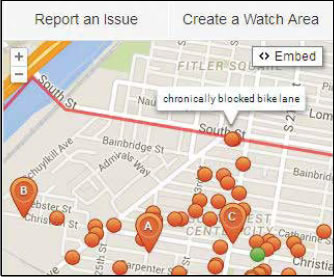
"Crowdsourcing" is a term for the process of gathering knowledge provided by various users through web and mobile applications. Currently, there are many websites and apps – such as MindMixer, SeeClickFix, Open Town Hall, and Open Street Maps – that make use of crowdsourcing and can offer additional ways for community members to communicate and build support or consensus for a pedestrian and bicycle project. For example:
While social media and crowdsourcing tools can be a powerful part of community engagement, keep in mind that there may be some folks in the community who are not comfortable with these tools, have disabilities or limited access to such technologies, or require translation to other languages. Also, these services and applications may not be available everywhere (e.g., if a jurisdiction is not registered on SeeClickFix) or there may be an initial cost for gaining access to the services. Therefore, use social media and web-based tools to complement other forms of partnership and engagement that are inclusive to a broader set of your community.
Your local transportation or public works department or agency may have a number of options and also face a variety of challenges when it comes to addressing pedestrian and bicycle safety issues in your community. Understanding these potential challenges and having a sense of the types of treatments that may be available can help you to build a better dialog and be more successful in advocating for improvements.
"There's not a problem there."
Many agencies identify and prioritize pedestrian
and bicycle safety concerns (and locations
where improvements will be made) by analyzing
the pedestrian- or bicyclist-motorist collision
(or crash) data. While crashes are one way to
determine problems, just because a collision has
not recently occurred does not mean that there
is not a problem. By providing evidence of your
concern (e.g., photos, videos, witnesses) you will
be more likely to convince officials to investigate
the site and/or open up communication with the
affected residents. See Section 1 or Resource 2 for
more on ways to identify and document concerns.
In some cases, you may have to recognize that
there are other more pressing concerns that need
to be addressed before the agency can focus
attention on your community's issue.
"We don't have the money or budget to make
pedestrian or bicycle improvements."
One common concern of agencies is: "We don't
have the money or budget to make pedestrian
or bicycle improvements." Having an idea of how
a street improvement project can be funded
and what upcoming opportunities can help you
overcome this potential roadblock.
Generally, local governments have capital improvement plans (CIPs) that include the major roadway, sidewalk, and other infrastructure improvements the community plans to complete. The CIP is a multi-year list of projects that are updated regularly. Items included in the CIP tend to be fairly expensive and/or large scale and are planned years in advance. Smaller, less expensive construction and improvement projects may not be placed in a CIP, but could be considered on an as-needed basis. Federal and State funds can also be used to fund surface transportation improvements, trails, community based-projects, and pedestrian or bicycle projects and programs. The Statewide Transportation Improvement Program (STIP) and Transportation Improvement Program (TIP) are prioritized, fiscally-constrained, and multi-year lists of transportation projects for States and local areas. Find out if there are any projects currently in the CIP, TIP, or STIP that may affect your area of interest and if so, how they plan to address pedestrian or bicycle issues; if not, try to learn more about what projects may be selected for these improvement plans in the future.
Local funds such as local tax revenue or special bonds may be another option. If a special bond is passed, depending on the size of the bond, there may be a substantial amount of funding available for sidewalk improvements, enhancements around transit facilities, or integration of pedestrian and bicycle treatments at new school sites. For smaller projects, local operating and maintenance budgets (allocated through yearly budgets) can typically support short-range or low-cost improvements such as signing and pavement markings. Your organization may be able to support a ballot measure, or work with town council to advocate for additional local operating funds. An innovative approach to funding pedestrian safety improvements is to break a large project into small pieces or phases that can be "purchased" by the public. Civic organizations (such as Lions Club), youth groups (such as YMCA or Girl Scouts), retirees, health and safety organizations, or even church groups might be willing to partner with you to help raise community funds. Also, contact your local chamber of commerce to identify ways in which the corporate and business community might be able to participate in fiscal support or program sponsorship. Be sure to publicize the participation of any group that supports you. See Resource 12 for more fundraising tips.
Ultimately, residents may have to accept that there is limited funding available but there are innovative techniques and strategies that communities can undertake to help provide funding for improvements or programs identified through a collaborative process with local stakeholders.
"I'm worried about the effects of pedestrian or bicycle improvements on other transportation modes." Sometimes, pedestrian or bicycle improvements (such as changes in signal timing to allow more time for pedestrians and bicyclists to cross roads) may increase the delay experienced by other road users, such as transit riders and automobile drivers. Transportation agencies with a focus and priority on safety will usually tolerate increases in delay to other road users, so long as there is a clear safety benefit. Effectively communicating pedestrian and bicycle issues to agencies and agency officials regularly may encourage a more balanced approach to transportation engineering and planning, thus ensuring all modes, including pedestrians and bicyclists, are adequately considered in the process. Another approach is to advocate for a temporary installation of the treatment, which can enable agencies to see firsthand the benefits of a new facility and better understand its potential impact on other modes. For example, many communities around the U.S. are participating in Better Blocks programs to demonstrate new facilities: http://betterblock.org. See the Community Success Story section for more on how Memphis and other cities incorporated Better Blocks events into their efforts to improve safety for pedestrians and bicyclists.
"If we make this improvement here, we will have to do it everywhere." Transportation agencies may fear making an improvement in one location if they think they would then be required to make it everywhere, which may incur additional costs. One way to avoid this concern is to work with agencies to help them establish clear guidelines that describe when an improvement is appropriate, a method for prioritizing projects, and/or how such improvements might be funded (see the discussion on budgeting for improvements above).
Following are some potential treatments that your agency may consider to improve safety or mobility of pedestrians and bicyclists. Having a shared vocabulary of these can help you understand and discuss the options available, but remember that your job is to primarily identify the problems, and the engineer is ultimately responsible for identifying the most appropriate solution(s).
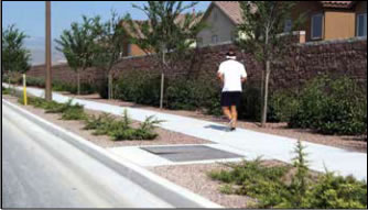
A paved walkway that allows pedestrians to walk next to the roadway without interference from traffic.
Q: Will sidewalks increase crime?
A: More pedestrian activity usually reduces street crime by providing more "eyes on the street."
Q: Will sidewalks decrease property values?
A: Walkable neighborhoods often have higher property values because homes in locations where residents can safely walk to schools and other nearby destinations are desirable.
Q: Do we have to cut down trees to create space for sidewalks?
A: Sidewalks can often be constructed without damaging trees by building around significant trees or narrowing/removing traffic lanes to provide space for sidewalks.
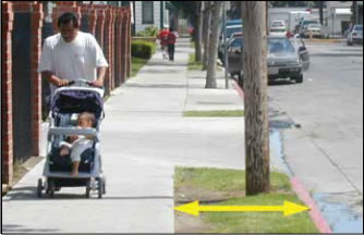
A zone separating pedestrians on sidewalks from moving vehicles on the road.
Purpose/Benefits
Agency Considerations
Q: Will adding buffer space mean the sidewalk will be located closer to houses or businesses?
A: Buffer space can be added by removing or narrowing roadway travel lanes in established neighborhoods, as well as by moving the sidewalk further from the roadway.
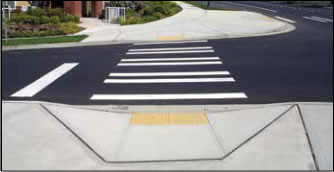
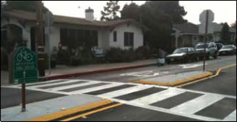
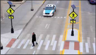
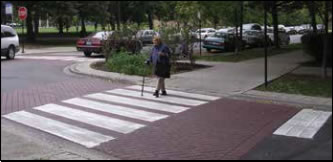
Areas on the street (delineated by pavement markings) indicating to pedestrians where they should cross the road.
Purpose/Benefits
Agency Considerations
Q: Will adding a marked crosswalk to an intersection or midblock location make it safer?
A: A marked crosswalk does not ensure a safe crossing. Signs, signals, lighting improvements, or traffic calming devices may also be needed, in combination with marked crosswalks, to improve pedestrian safety. If facilities are in place and drivers still fail to yield to pedestrians in marked crosswalks, sometimes targeted, high-visibility law enforcement is needed.
A ramp providing a smooth transition between sidewalk and street.
Purpose/Benefits
Agency Considerations
Q: I see many types of curb ramps in my neighborhood. What type is the most effective?
A: The ADA Accessibility Guidelines describe required design elements for curb ramps such as landing space, specific width and slope, and tactile warning strips (bumps). Consult your local transportation or public works department for more information.
Q: Where are curb ramps required?
A: Curb ramps are required wherever there is a pedestrian crossing.
These provide pedestrians with a safe place to wait while crossing a street in multiple stages.
Purpose/Benefits
Agency Considerations
Common Resident Questions and Answers
Q: Do raised medians make it more difficult for cars to use driveways or access buildings?
A: A raised median will not affect right turns in and out of driveways or side streets. Left turns would be redirected to a major crossing, which reduces potential conflicts and increases safety for drivers and pedestrians.
Q: What would warn motorists of a person wanting to cross?
A: Signs, pavement markings, and sometimes flashing beacons alert motorists of a pedestrian waiting to cross.
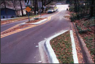
An extension of the sidewalk into the street that reduces the distance pedestrians must cross.
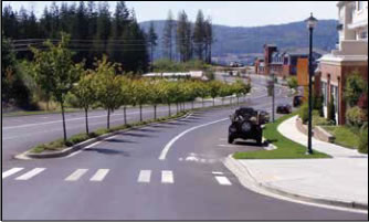
Purpose/Beneits
Agency Considerations
Q: Won't curb extensions eliminate on-street parking?
A: Curb extensions do not typically affect on-street parking, as parking is not permitted at corners.
Q: Why aren't these installed at every crossing?
A: Curb extensions are most effective on streets with on-street parking. They are not an alternative for streets with high-speed traffic or without on-street parking because drivers would not expect sudden changes in the roadway width.
Bike lanes
Striping and symbols are used to delineate the portion of the roadway that is for exclusive use by bicyclists.
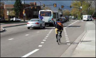
Purpose/Benefits
Agency Considerations
Q: Why aren't bike lanes installed on every street?
A: Not every street has adequate space for a bicycle lane. A bicycle lane should be a minimum of five feet wide for a bicyclist to ride comfortably.
Q: Do bike lanes improve safety for bicyclists?
A: Bike lanes have been found to provide more consistent separation between bicyclists and passing motorists than shared travel lanes.
A pavement marking that offers guidance to bicyclists on where to ride while alerting motorists to the presence of bicyclists within a lane shared by both bicyclists and drivers.
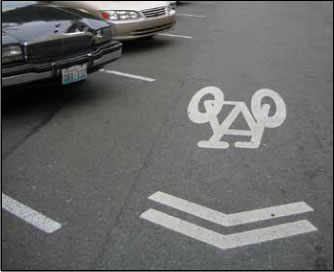
Purpose/Benefits
Agency Considerations
Q: Why should a shared lane marking be used instead of striping a bike lane?
A: Shared lane markings and bike lanes are not interchangeable. If a road is not wide enough for a bike lane to be striped next to a motor vehicle travel lane, then a shared lane marking may be useful to help bicyclists and motorists understand where the bicyclist should be positioned within the shared lane. Shared lane markings can also be used to fill in the gap between two sections of roadway with bike lanes.
Q: Is the bicyclist required to ride across the path of the shared lane markings?
A: No, but riding in the path of the markings should encourage safe passing by motor vehicles and, with proper placement, help ensure that the bicyclist is not riding in the "door zone," where the opened door of a parked vehicle could strike the bicyclist.
Bicycle facilities that run alongside a roadway separated from automobile traffic by a physical barrier, such as parked cars, bollards, or a curb.
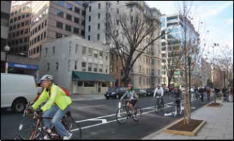
Purpose/Benefits
Agency Considerations
Q: Are separated bike lanes used in residential neighborhoods?
A: Separated bike lanes may be one component of a community's bicycle network, which also could include bike lanes, shared use paths, neighborhood greenways, and other types of facilities. Separated facilities are most commonly installed on high-traffic corridors where there is likely to be a high volume of bicyclists (i.e., near an urban center or university campus). However, this is a relatively new design in the U.S. and engineers are still determining the best applications. For example, they can also be used to provide connections from residential neighborhoods to transit stops, or to provide an on-street connection between off-street paths.
Q: Do separated bike lanes require eliminating parking spaces?
A: Sometimes parking spaces are removed or reassigned, but if there is adequate right-of-way, parking lanes can be moved away from the curb to create a separated bike lane and provide a buffer for bicyclists from moving traffic.
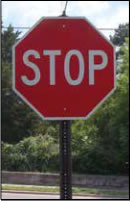
An official device that gives a specific message, either by words or symbols, to the public. Examples are "Stop," "Yield," etc.
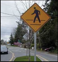
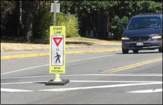
In-Street Pedestrian Crossing Sign
Purpose/Benefits
The two types of signs affecting pedestrian safety are:
Agency Considerations
Q: Motorists don't obey signs in my neighborhood. How are placing these signs going to help?
A: In some cases, simply installing a sign is not enough to change driver behavior or improve pedestrian safety. Signs should be used in conjunction with enforcement and other improvements that physically change the roadway environment.
Q: I don't see why a sign in my neighborhood is needed. What should I do?
A: Talk to your local transportation agency or department of public works to find out if the sign is needed. Sometimes a previously-needed sign may not have been removed as conditions on the street changed. Typical examples of this are school warning signs and bus stop warning signs. School zones and school bus stops are determined by the school district and may change without immediate knowledge of the local transportation agency.
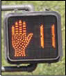
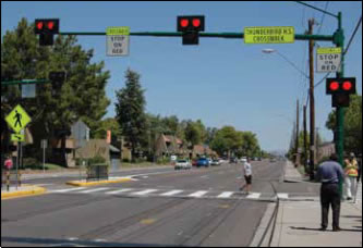
A visual signal to control the flow of traffic. Pedestrian signals let pedestrians know when they can enter the street to start crossing.
Purpose/Benefits
Agency Considerations
Q: How can a traffic signal improve pedestrian safety?
A: Having more time to cross a street, giving pedestrians a head-start, or timing a signal so vehicles cannot turn while pedestrians are crossing the road can all improve pedestrian safety. Consult your local transportation or public works department to see if improvements at particular intersections are possible.
Q: Why do I have to press the push button: won't I get a walk signal anyway?
A: On some streets pedestrians may have to push the button to get a signal that gives them enough time to cross the street. Talk with your traffic engineer about the pros and cons of having a push button to activate the signal versus automatically including the walk signal.
An overhead beacon that assists pedestrians at crossing locations that do not have a traffic signal.
Purpose/Benefits
Agency Considerations
Q: How is the pedestrian hybrid beacon different from a traffic signal?
A: The beacon rests dark until a pushbutton or detector is activated by a pedestrian or bicyclist. The beacon does not have a green indication, but uses alternately flashing and solid amber and red beacons. Similar to a traffic signal, drivers will get a red indication while pedestrians get a WALK signal. However, during the flashing don't walk interval, drivers will get a flashing red indication allowing them to proceed after stopping if they are not in conflict with the crossing pedestrians. Pedestrian hybrid beacons can be used at corners and at midblock locations, like where a trail crosses a roadway and continues on the other side.
A bright, irregularly flashing beacon that is placed at crosswalks without stop signs or traffic signals to warn drivers about the presence of crossing pedestrians.
Purpose/Benefits
Agency Considerations
Q: How effective is this in getting drivers to yield?
A: Several studies have shown that RRFBs, in the appropriate context, are more effective in getting drivers to yield to pedestrians in marked crosswalks than other treatments such as in-street "Yield to Pedestrian" signs, overhead signs, or in-pavement flashing lights.
Q: Will the bright lights be flashing 24/7?
A: An RRFB is different from a standard flashing beacon because it is only activated when a pedestrian is automatically detected or presses a pushbutton. If the beacon was flashing all the time, drivers may become accustomed to the lights and less likely to detect when a pedestrian is there or not.
Physical changes to a street to encourage drivers to drive slowly or to discourage cut-through traffic.
Agency Considerations
Q: Why can't we just install stop signs at every intersection to slow traffic?
A: Residents often believe that stop signs are the best way to reduce traffic speeds. Using too many stop signs can breed disrespect for signs among drivers and lead to increased running of stop signs and higher speeds between stops. Certain conditions must be met before stop signs should be added as an effective solution for controlling traffic. For a summary of traffic studies conducted on this topic visit: http://bit.ly/1wj7jE3
Q: Won't installing speed humps slow down traffic?
A: You may first think of a speed hump when thinking about slowing down traffic. Consideration must, however, be given to the impact on:
Chicane
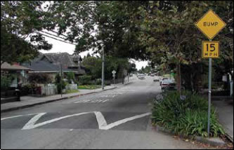
Speed Hump
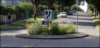
Traffic Circle
Raised Crosswalk
Narrowing or eliminating travel lanes on a roadway to make more room for pedestrians and bicyclists.
Purpose/Benefits
Agency Considerations
Q: Won't this cause more traffic congestion?
A: A road diet can't be applied to every street. Road diets are most effective where traffic volumes can be accommodated with fewer lanes. When applied appropriately, traffic will remain relatively unchanged.
A street crossing separating pedestrians and bicyclists from motor vehicle traffic (i.e., bridge or tunnel).
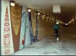
Purpose/Benefits
Agency Considerations
Q: Why aren't overpasses or underpasses always used for dangerous street crossings?
A: Overpasses and underpasses are not the right solution for every dangerous crossing. Not only can they be expensive, but sometimes it is better to make the crossing safer at the roadway level. If overpasses/underpasses require pedestrians and bicyclists to travel out of their way, the crossing is often not used. To ensure pedestrians and bicyclists use an overpass or underpass, it must provide an easy and direct path to key destinations.
Q: Aren't underpasses unsafe?
A: Residents sometimes voice concerns about the security of an underpass. Design elements can be considered to make them more secure: 1) underpasses should be straight to eliminate hiding places and so users can see the "light at the end of the tunnel"; 2) they should be as short and wide as possible and open so pedestrians and bicyclists don't feel trapped; and 3) they should be well-lit.
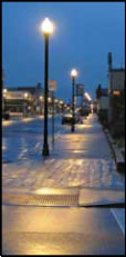
Photo: Street lights
This illuminates the roadway and intersections to help motorists see other motor vehicles and pedestrians crossing the roadway.
Purpose/Benefits
Agency Considerations
Q: Will lighting increase pedestrian activity?
A: Lighting may help pedestrians feel safer and more secure, which may mean more people will walk. More "eyes on the street" can help deter criminal activity.
Q: Will new lighting destroy the character of our neighborhood?
A: Some residents may be concerned about lighting and its impact on the nature of the neighborhood. There are many options for lighting design including height, direction, and luminosity that can be tailored to fit the community.
These provide pedestrians with designated routes along a construction site when sidewalks and other pedestrian travel ways have been closed.
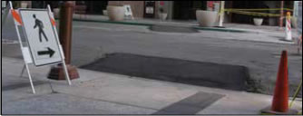
A Stable, Temporary Curb Ramp
Purpose/Benefits
Agency Considerations
Q: I have to walk through a construction zone every day and it changes almost as frequently. How can I anticipate my walking route?
A: Construction firms are required to submit traffic control plans that specify how they will maintain pedestrian and motor vehicle access. These will be on file with your local transportation agency or department of public works.
Q: What do all these signs in construction zones mean?
A: Construction signs usually warn motorists, bicyclists, and pedestrians of changes in the street environment. All signs must be prominently displayed in advance of the hazard.
For more details on common pedestrian and bicycle treatments, visit the following resources:
Here are some points you can use when talking to elected leaders, neighbors, or others about why it is important to make your community safe and inviting for bicyclists and pedestrians:
For more talking points and research findings on the benefits and importance of walking and bicycling, please visit:
http://www.pedbikeinfo.org/data/factsheet.cfm
http://bikeleague.org/reports
http://bit.ly/1t7NgHU
Here is one example of the typical format of a city resolution. This one was used by communities that pledged to support a comprehensive pedestrian and bicycle safety program in North Carolina. To learn more about the program, visit www.watchformenc.org.
WHEREAS, it is a priority of the City to protect human health and safety; and
WHEREAS, the City recognizes bicycling and walking as important and viable modes of transportation and recreation; and
WHEREAS, the City recognizes the importance of educating pedestrians, bicyclists and drivers on how to share the road safely; and
WHEREAS, the North Carolina Department of Transportation is leading a pedestrian and bicycle safety campaign known as Watch for Me NC; and
WHEREAS, the North Carolina Department of Transportation is seeking commitment from NC communities for involvement in the Watch for Me NC campaign; and
WHEREAS, the Watch for Me NC campaign would provide safety education for pedestrians, cyclists, and drivers through various strategies; and provide training to officers to support enforcement activities and provide information for campaign evaluation.
NOW THEREFORE BE IT RESOLVED THAT THE CITY COUNCIL, pledges in cooperation with the North Carolina Department of Transportation to participate in the Watch for Me NC campaign.
Adopted this (INSERT DATE).
ATTEST:
Name (Mayor) ________________________________________________________________________________________
Name (City Clerk)________________________________________________________________________________________
For more personal travel safety tips and instructions on properly fitting a helmet, visit http://bit.ly/14XP9h0.
Chief of Police or Sherriff:_________________________________________________________________________________________________
Head of Traffic Squad: _________________________________________________________________________________________________
Head of Bike Patrol Squad: _________________________________________________________________________________________________
Key Community Patrol Officer: _________________________________________________________________________________________________
Key School Resource Officer: _________________________________________________________________________________________________
Speeding: _________________________________________________________________________________________________
Failure to yield to pedestrians in/at crosswalks: _________________________________________________________________________________________________
Clearance requirements for vehicles when passing bicyclists: _________________________________________________________________________________________________
Reckless driving:_________________________________________________________________________________________________
Distracted driving/cell phone use:_________________________________________________________________________________________________
Requirements for where bicyclists can ride (e.g., take whole lane):
Helmet and/or bike light requirements:_________________________________________________________________________________________________
Jaywalking or pedestrian failure to give right-of way: _________________________________________________________________________________________________
Others:_________________________________________________________________________________________________
Following is a sample "warning" letter to drivers, adapted from the Harborview Injury Prevention & Research Center's Streets For People, Too! guide. It can be used by police when stopping drivers to help raise awareness of pedestrian and bicyclist safety needs and laws without having to issue a formal citation.
Dear (driver):
You have received the enclosed written materials because your vehicle was seen traveling through the (insert name of community) neighborhood along (insert street location) on (insert date). The car was also observed failing to stop for pedestrians in a crosswalk [or speeding, passing too closely to a bicyclist, etc.]. The purpose of this letter is to make you aware that (insert name of community), along with several other neighborhoods, is participating in a special program to help make streets safer for people who walk and bike.
Extra traffic police have been assigned to (insert name of community) to ticket drivers who fail to stop for pedestrians, pass too closely or drive recklessly around cyclists, or who speed through this community. The intent of this message is to help you avoid a hefty (insert dollar amount) fine as well as to reduce the number of tragic pedestrian and bicyclist injuries and deaths that occur in (insert name of community) each year. More and more people are walking and bicycling, and we need your help in making the streets safe for everyone. Please read the enclosed materials (insert information about the law) and familiarize yourself with laws affecting pedestrians and bicyclists and your obligation as a driver. Pass the word along to your friends and family, too! Thank you for your attention to this message and to people who are walking and bicycling in this community.
Drive safely!
(name of safety coalition chair or law enforcement representative)Remember… Safety is a shared responsibility!
Whether you are bringing together community members and stakeholders to exchange ideas, support a cause, or celebrate walking and bicycling, hosting an event – such as a Walk to School Day, Bike to Work ride, Sunday Parkways event, etc. – can be a major undertaking. Below are some simple steps you can take to make the planning easier and the big event more successful.
Think about the timing of the event, where it can be located (or the route a ride or walking tour will take), and who needs to be involved in order for it to be a success. Bring those people into the process early by forming a planning committee. Also consider the safety of people participating and if liability insurance is needed – this can take time to sort out, so advance planning is important.
Think about what materials you will need (giveaways, marketing materials, signage, etc.), and how to cover such costs. For example, if you're planning on hosting a cycle clinic and handing out bike helmets, you can try working with a local Safe Kids coalition or bike shop to get helmets donated for the event. For more ideas on fundraising, see Resource 12. If you are planning a large event in a public space or road, you may need to coordinate with police, schools, or town/city staff to get appropriate permits or use agreements or to have city staff provide support for your event. Consider how many people are needed to help work the event and then recruit and coordinate with volunteers. You may find volunteers through your neighborhood, local bike clubs/advocacy groups, members of your town's pedestrian/ bicycle advisory council, civic groups, or other organizations.
Spread the word about your event in as many ways as possible. Depending on the audience you wish to reach, you can post ads in the local paper; make announcements through the school PTA newsletter; use a neighborhood or workplace listserv; post yard signs; and invite participants using social media. For more tips on using social media, see Resource 4.
After your event, be sure to recognize and thank your volunteers, sponsors, and others that provided support. If you can, try to gather feedback from event participants and coordinators to help you evaluate successes and make improvements if you have another event in the future.
For more details, check out the following event- specific planning guides:
National Bike Month Event Planner Kit
http:/bit.ly/1vwpW8s
Walk to School Day Getting Started Guide
http://bit.ly/1xccW3k
NHTSA Cycling Skills Clinic Guide
http://1.usa.gov/1qHWJ9j
City of Portland Sunday Parkways Manual
http://bit.ly/1p6cAxo
The Open Streets Guide
http://openstreetsproject.org/guide/
Whether you are seeking funds to support a local event, raise money for a Safe Routes to School program, pay for educational/outreach materials, or other effort, there are many opportunities for finding funding and other forms of support. Below are a few ideas to help you brainstorm what may be available and appropriate in your community.
City, police, recreation departments, and schools may be able to set aside funding in their operating budgets to support non-infrastructure activities or low-cost improvements. Some cities, such as Washington, DC, have local neighborhood commissions with budgets that can be used to address neighborhood issues. Ask your elected council person what options may be available, and what the process or timeline is for making budgetary requests.
PTAs, homeowners associations, or other local groups could be a resource for finding or raising funds. If you're seeking bike helmets to donate, local Safe Kids chapters often are able to donate such materials to local events. Local A A A or A ARP chapters could also have funding available if a case can be made for how your initiative relates to its goals or members.
There are thousands of charitable funds and foundations across the U.S., many of which may be willing to support efforts to improve walking and bicycling safety. The key is identifying what local opportunities exist, understanding which ones may be a good match for your goals and interests, learning about their process for applying for funding, and writing a strong proposal. To start, you can go to http://bit.ly/1zJYMth and search the Free Online Foundation Directory to locate potential funders. In many instances, your local library will have access to a more robust subscription service that can help you identify a shortlist of appropriate funders. When applying for funding, be sure to tell a compelling story about yourself and the work you are looking to do in the community and the impact you believe it will make. Also, showcase your group's ability to perform the work; one strateg y to do this is to show that you have strong partners in place and provide letters of support from your partner network. See Section 2 for more on partner formation.
Hospitals, health insurance companies, and foundations with an interest in health, such as the Robert Wood Johnson Foundation (RWJF), have been active in many local efforts to improve walking and bicycling and are a natural partner. Many communities have been able to use grants from tobacco settlements or other initiatives to improve health through walking and bicycling initiatives. Visit the RWJF grant website (http://bit.ly/1F93MbW) and talk to others in your community, including city and health department staff, regarding how your organization can partner with the municipality or others to pursue a health- related grant.
Local businesses including grocery stores, outdoor merchandisers, restaurants, shoe stores, and bike shops – may be willing to provide funding or to sponsor an event. FedEx, Food Lion, REI, and Performance Bike are just a few examples of large retailers that have donated materials or provided support or in the past to local pedestrian and bicycle safety initiatives. In some places, the local power company has supported efforts to install street lighting. Locally-owned restaurants often donate food for meetings and/or events or are willing to provide coupons that can be printed on event fliers and promotional materials to attract participants. Franchised or chain restaurants may also be supportive, but many have more lengthy corporate processes to go through before they can proceed, so plan to reach out to them well in advance. Local graphic design firms may offer pro-bono design services, such as designing signs and materials such as fliers and t-shirts for an event, or even a website. If you are reaching out to local businesses, it will be important to show how supporting your cause, event, or improvement will be good for their business (e.g., more/healthier/ safer customers and employees, exposure of their brand, etc.). Have your "elevator speech" and specific "ask" ready before you approach them.
Many organizations – such as the National Center for Safe Routes to School, Smart Growth America, People for Bikes, the Alliance for Bicycling and Walking, and the Safe Routes to School National Partnership – periodically offer mini-grants and or free technical assistance workshops to support local efforts. Visit their websites or join their mailing lists to find out about when such opportunities arise.
The funding portal includes info about available
mini-grants and details on local, private, and
federal funding that can be used for SRTS
programs.
http://bit.ly/1ujJLt1
SPARK Grant-Finder Tool
Helps you locate funding for your Physical
Education, After School, Early Childhood,
Classroom Activity, or Coordinated School Health
program. Grants can be used for curriculum,
teacher training, or equipment.
http://bit.ly/1xyW0Ie
The Art and Science of Personal Solicitation
A guide for seeking large gifts (of $25,000 or more)
from private donors.
http://bit.ly/11CUDLN
| < Previous | Table of Content |

