U.S. Department of Transportation
Federal Highway Administration
1200 New Jersey Avenue, SE
Washington, DC 20590
202-366-4000
| < Previous | Table of Content | Next > |
Land use and transportation have an extremely complex interrelationship. Often times, problems with the transportation system are blamed on faulty land-use policies and vice versa-problems with sprawling land uses are blamed on transportation policies. In fact, the problems typically do not have simple cause-and-effect solutions. This lesson takes a look at ways in which land-use regulations can be improved to support an intermodal transportation system that encourages access by walking, bicycling, and transit.
Most communities in the United States have landuse regulations that primarily support automobile access to local destinations. Substantial changes to zoning laws and subdivision regulations will be necessary in many communities in order to accomplish fundamental improvements to the transportation system. In addition to ordinances that require bicycle parking and sidewalks, even more basic changes are needed to automobile parking requirements, street design standards, allowable land-use densities, and transitoriented developments.
Revising regulations that have been in place for many years can be a daunting task - either for planners who are trying to re-model a development ordinance or for engineers who are trying to change street design standards to accommodate bicycle and pedestrian travel. This chapter provides some examples of the types of provisions that are included in new policies on the State and local levels in order to accommodate and encourage bicycle and pedestrian travel.

One of the most important factors in a person's decision to walk or bike is the proximity of goods and services to homes and workplaces. A recent study for the Federal Highway Administration confirms this: 33 percent of survey respondents cited distance as the primary reason for not walking. The most conducive land use for pedestrian activity is one with a higher density mix of housing, offices, and retail. Studies have also shown that more people walk in areas that are able to achieve higher densities of either housing or employment, despite lower densities of other uses such as retail. One study of the Puget Sound Region in Washington State defines high density as 50 to 75 employees per acre, or 9 to 18 residents per acre.
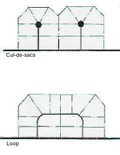
Loops are preferred to cul-de-sacs. Source: Wilmapco, Mobility-Friendly
Design Standards, Wilmington Area Planning Council, 1997.
Low-density single-use zoning creates trip distances that are too far
to make walking a viable transportation option.
Pedestrian and bicycle travel is often an afterthought in the development process. The results are impassable barriers to pedestrian travel, both within and between developments. The examples below show how local zoning ordinances can be amended to require more attention to the needs of pedestrians and bicyclists.
Typical alley: Ordinances should be modified to allow for rear-lot access.
Many communities throughout the country are conducting extensive revisions to their zoning and subdivision regulations in light of new planning techniques that improve transportation and community design.
New rules that would allow parking reductions and higher density developments are likely to be controversial. Public education for citizens and elected officials is essential in order to gain popular support for these new regulations.
The City of Portland, Oregon recently conducted an extensive revision of local zoning and subdivision regulations, using a successful technique that encouraged involvement from citizens and local elected officials. The city conducted a well-publicized Visual Preference Survey TM, allowing local citizens to establish a vision for their ideal community environment by comparing photographs of different styles of urban, suburban, and rural development. When shown side-by-side, photographs of suburban strip development were rated far lower than those showing more compact, mixed-use districts. (Picture This. . . The Results of Visual Preference Survey, 1993)
Land developers should be asked to submit a "Pedestrian and Bicycle Mobility Plan" early during the site plan review process. This plan should provide an inventory of all existing and proposed land uses adjacent to the site, and illustrate a logical circulation plan for pedestrians and bicycles within the development and between adjacent land uses. The questions below can help design professionals create site plans that are sensitive to the needs of pedestrians.
SITE PLAN CHECKLIST
Overall System
- Does the plan meet ADA standards?
- Are utilitarian paths direct? Do they provide for connections to pedestrian magnets nearby? Can pedestrians take advantage of "shortcut paths" that encourage walking instead of driving?
- Does the pedestrian system consider the type and probable location of future development on adjacent or nearby parcels of land? Is there flexibility to provide direct connections to adjacent parcels; should that be desired in the future?
- Are building entrance areas convenient to the pedestrian? Are they clearly evident through either design features, topography, signing, or marking?
- Are walkways along the street buffered from traffic as much as possible?
Safety and Security
- Are crossings of wide expanses of parking lot held to a minimum?
- Are pathways generally visible from nearby buildings and free from dark, narrow passageways?
- Is adequate pedestrian-scale lighting provided for nighttime security?
- Are sight lines at intersections adequate for pedestrian visibility? Are pedestrians able to see on-coming traffic, given typical speeds?
- Do pathways lead to road crossing points with the least conflict?
- In general, are pedestrian/vehicle conflict points kept to a minimum?
- Are pedestrians given adequate time to cross the road at intersections?
The physical layout of a development can often make the difference in a person's choice to walk between stores or to adjacent developments. Careful attention should be given to the location of buildings as well as the configuration of parking lots. Several provisions can ensure a better walking environment in commercial and office developments:
| Location of lighting | Lux (lx) | Footcandles (fc) | |
|---|---|---|---|
| Sidewalks Along Roadsides: | Commercial areas | 10 | 0.9 |
| Intermediate areas | 6 | 0.6 | |
| Residential areas | 2 | 0.2 | |
| Sidewalks Distant From Roadsides: | 5 | 0.5 | |
| Pedestrian Tunnels: | 40 | 4.0 | |
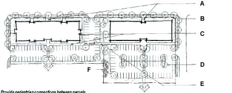
Provide pedestrian connections between parcels.
Suburban neighborhood design can be modified to encourage bicycling and walking. It is not necessarily more expensive to build these communities; however, they require more careful design on the part of the developer. These types of pedestrian-friendly neighborhoods are worth the effort. Recent studies suggest that homes sell quickly in these communities. (See Lesson 6 for a more complete description of traditional neighborhood development.)
A pedestrian-oriented neighborhood should include the following aspects (list below is taken from the ITE Journal, January 1992 edition, pp. 17-18, "Neo- Traditional Neighborhood Design and Its Implications for Traffic Engineering"):
In New Castle County, Delaware, the regional planning agency and the Delaware Department of Transportation have teamed up to further define the precise design standards that should apply to local and collector streets. Following the references are the results of a study that was conducted in 1997- 1998 to revise State design standards (see next page).
Text and graphics for this section were derived from the following sources:
American Planning Association, Oregon Transportation Planning Rule, 1993.
Birmingham Regional Planning Commission, Walkable Communities in the Birmingham Area, 1996.
Madison (WI) City Code, Madison, Wisconsin.
Wilmington (DE) Planning Council, Mobility- Friendly Design Standards, 1997.
For more information on this topic, refer to:
Town of Davidson, NC, Davidson Land Plan, (The Regulating Plan and Code), Oct. 1995.
Maryland Office of Planning, Managing Maryland's Growth, Modeling Future Development on the Design Characteristics of Maryland's Traditional Settlements, 1994.
WILMAPCO - MOBILITY FRIENDLY DESIGN STANDARDS STUDY
DELAWARE DESIGN / POLICY GUIDELINES FOR LOCAL & COLLECTOR STREETS
Purpose of study:
This study supports the long-range transportation goals of the Delaware Department
of Transportation, Town of Middletown, New Castle and WILMAPCO. These goals
include increasing mobility and accessibility by providing people with a range
of travel options. Transportation improvements should be integrated into the
social fabric of communities to help create livable neighborhoods and provide
an expanded network of connections within and between communities. The goal
is to provide an excellent transportation and land use system that is sustainable
and provides access and mobility options.
Street Design Criteria:
As part of this study, the consultant team is exploring opportunities to provide
flexibility in neighborhood street design through reduced lane width and other
geometric design criteria. The benefits of this approach include:
Application:
DelDOT Blue Book (Rules and Regulations for Subdivision Streets - 1981)
| DelDOT | AASHTO | ITE | ASCE | RECOMMENDED | COMMENTS | |
|---|---|---|---|---|---|---|
|
||||||
| Minor Streets, Minor Collector Streets | Not specified | Reference FHWA; "Highway Functional Classification; Concepts, Criteria and Procedures" | Curvilinear designs with interconnections as direct as possible | Linear or curvilinear design/short distances to collectors | Short interconnected streets/direct routes/loops preferred
to cul-de-sacs
Consider Network Connectivity Index of 1.4 as design minimum target |
The goal is to provide greater mobility options for pedestrians and bicyclists |
|
||||||
| Minor Streets, Minor Collector Streets | Not specified | While not specified, spacing of minor arterial streets may vary from 1/8 to ½ mile in CBD and 2 to 3 miles in suburban fringes | Limited number of intersections | Minimum number of intersections | 200' to 500' (blocks longer than 500' require midblock crosswalks and pass-throughs based on walkability.) | |
|
||||||
| Minor Streets | 25 mph | 20 to 30 mph | 20 mph (hilly) 25 mph (rolling) 30 mph (level) |
20 mph | 20 mph (desired operating speed is 20 mph) Require engineering study to support 20 mph - otherwise need to change statutes. | Design speed and desired operating speed: 20 mph |
| Minor Collector Streets | 30 mph or greater | 30 mph or greater | 25 mph (hilly) 30 mph (rolling) 35 mph (level) |
25 mph (hilly) 30 mph (rolling) 35 mph (level) |
25 mph (desired operating speed is 25 mph) | Design speed and desired operating speed: 25 mph |
|
||||||
| Minor Streets | 150' | 100' min. (desirably as large as possible) | 100' (hilly)
180' (rolling) 300' (level) |
100' to 150' (access street) 150' to 300' (subcollector) |
90' when curve is unsigned
45' when curve is signed as a traffic calming measure |
Additional engineering analysis to be conducted by DelDOT |
| Minor Collector Streets | 300' | 300' to 500' | 150' minimum
90' when curve is signed as a traffic calming measure |
Vertical curve issues to receive further study by DelDOT | ||
|
||||||
| Minor Streets | T-Intersection 90° | Type is primarily determined by the number of intersecting legs, the topography, the traffic pattern, and the desired type of operation | T-Intersections (4-way intersections and roundabouts are also acceptable) | T-Intersections or 4-way
Provide: Intersections with roundabout or other traffic calming measures |
Consider permitting "L" curves, i.e. 90' turns for loop or U shaped roadways. Loops preferred to cul-de-sacs. Consider permitting 60' for local streets. Reference recently released ITE manual-Traditional Neighborhood Development Street Design Guidelines, June 1997. | |
| Minor Collector Streets | T-Intersection 90° | Roundabouts or 2-way stops or 4-way stops | Roundabouts are appropriate for locations with heavy minor street delay, heavy turning traffic, intersections with unusual geometry, where major roads intersect at a "Y" or "T" junction, or where u-turns are necessary. They are inappropriate for locations where a signal interconnect system is necessary, or queuing from adjacent intersections would back up into the roundabout. | |||
|
||||||
| Minor Streets / Minor Collector Streets | 25' | 15' minimum 25' desirable 30' (collector) |
15' to 20' (local-local) 25' to 30' (local-collector) |
10' (local-local) 15' (local-collector with parking lanes) 20' (collector-collector with parking lanes) 40' (local-collector without parking lanes) 40' (collector-collector without parking lanes) |
40' radius adds 9 seconds to pedestrian crossing (40' radius vs. 20' radius). Further consideration required regarding curb return radii / school buses. See page 2 of 10. | |
|
||||||
| Minor Streets / Minor Collector Streets | 500' to 1,000' (depending on density) | Not specified | 700' to 1,500' (depending on density) | 500' to 1,000' | 250' preferred to 500' maximum serving no more than 30 units with cut throughs provided at cul-de-sac heads for peds/bikes | |
|
||||||
| Minor Streets | 200' (narrower lots call for shared driveways) | Not specified, although desirably as far removed from intersections as practicable | 50' (narrower lots call for rear access via alleys) | |||
| Minor Collector Streets | 250' | |||||
|
||||||
| Minor Streets / Minor Collector Streets | 12' standard (not minimum) | Not specified ( but returns should not be less than 3' radius) | 10' minimum
18' (for 2-car garage on street) |
8' to 16' (single-family)
18' (multi-family) |
||
|
||||||
| Minor Streets | 50' (minor streets)
26' under special circumstances |
50' (with 26' roadway section)
66' (commercial areas with on-street parking) |
50' (low density)
60' (medium and high densities) |
24' (access street)
42' to 46' (subcollectors) |
42' or 49' = 20' or 27' roadway (no parking or one side) +
5' planting strip + 5' sidewalk + 8" top of curb
Traffic calmed environment - bicycles accommodated on shared facility |
44' or 51' total ROW including 1' offset from back of sidewalk |
| Minor Collector Streets | 60' (minor collectors) | 40' to 60' | 70' (low & medium densities)
80' (high density) |
52' to 56' | 51' or 56' = 29' or 35' roadway (parking on one side or both sides) + 5' planting strip, 5' sidewalk, 8' top of curb. If frontage on local collector 10' planting strip required each side, increasing ROW by 10'. Larger ROW allowed if a boulevard type median is provided. Designated bicycle accommodations provided based on traffic volume, speed and road section - see FHWA publication used by DelDOT. A local and/or regional analysis should be prepared to identify the destinations that bicycle users may seek. | 53' or 60' total ROW including 1' offset from back of sidewalk |
|
||||||
| Minor Streets | 22' (minor streets) | 26' (OK for less when ROW is severely limited) | 20' to 28' (low density)
28' to 34' (medium density) 36' (high density) |
22' to 24' (local access street)
26' (subcollectors) |
18' roadways (2 @ 9')
2' offsets to curb face (2 @ 1') --- 20' total ------------------------ 18' roadways (2 @ 9') 7' parking lanes 2' offsets to curb face (2 @ 1') --- 27' total |
|
| Minor Collector Streets | 32' (minor collectors) | 24' to 36' (low and medium densities)
40' (high densities) |
36' | 20' roadways (2 @ 10')
7' parking lanes 2' offsets to curb face (2 @ 1') --- 29' total ------------------------ 20' roadways (2 @ 10') 14' parking lanes 2' offsets to curb face (2 @ 1') --- 36' total |
||
|
||||||
| Minor Streets | 11' (minor streets) | 10' (travel lanes - use 11' where feasible; minimum in residential
areas 9')
7' (parking lanes - use 9' in commercial areas) |
10' (travel lanes without parking on both sides)
12' (travel lanes with parking on both sides) 8' (parking lanes) |
9' travel lanes (min)
7' parking lanes |
"Bulb-outs" at intersections encouraged
DelDOT to establish parking setback from intersections |
|
| Minor Collector Streets | 11'-4" with curb (minor collectors) | 10' (travel lanes)
7' (parking lanes - residential) 8' (parking lanes - commercial) |
10' travel lanes (min)
7' parking lane (striped) |
"Bulb-outs" at intersections encouraged
DelDOT to establish parking setback from intersections |
||
|
||||||
| Minor Streets | Mountable or barrier curbs (none at low densities i.e. ½ acre lot size & > 100' frontage & > 60' building setback) | Urban areas - curbs used extensively.
Rural areas - exercise caution in use of curbs. Normally vertical curbs |
None or roll-type curbs (low density)
Vertical curb (medium and high densities) |
Vertical or roll-type curbs at higher densities | 8" vertical curbs (whenever sidewalk provided). Vertical curbs stop vehicles from parking on landscaped buffer strip | |
| Minor Collector Streets | 8" vertical curbs (plus ADA entrance) | |||||
|
||||||
| Minor Streets | Not required by DelDOT - New Castle County requires on at least one side of all local streets with 10+ dwellings and densities of >1 unit/acre and on both sides of minor collectors | Both sides in commercial areas, at least one side in residential areas. | Only at medium and high densities | Not required on access streets.
One side of subcollectors |
2 units or more/acre sidewalks both sides; less than 2 units/acre
to 1 unit/acre sidewalks one side; greater than 1 acre lots - no side walks
All cul-de-sacs - sidewalks both sides |
|
| Minor Collector Streets | Not required by DelDOT - New Castle County requires on at least one side of all local streets with 10+ dwellings and densities of >1 unit/acre and on both sides of minor collectors | Both sides in commercial areas, at least one side in residential areas. | Both sides | Both sides | Both sides | |
|
||||||
| Minor Streets / Minor Collector Streets | Not specified by DelDOT (New Castle County required 5') | 4' (8' or more may be needed in commercial areas) | 4' to 6' | 4' minimum with planting strip
6' without planting strip |
5' (with buffer strip)
8' (without buffer strip) (at least 40 sq. ft. per person at peak times) |
|
|
||||||
| Minor Streets | Not specified | 12' (desirable) | 5' to 6' | 3' to 5' desirable | 5' minimum Zero permitted for commercial uses with minimum 8' sidewalk. |
|
| Minor Collector Streets | 10' | 3' to 5' desirable | 10' minimum, if lots front on residential collector streets | |||
|
||||||
| Minor Streets | Not specified | 16' to 20' in residential areas | 20' (alleys allowed but discouraged) | 12' (pavement)
16' (right-of-way) (recommended) when lot widths are less than 50' wide) |
12' (alleys or shared driveways are recommended when lot widths
are less than 50')
12' paved width acceptable provided 20' open ROW available Encourage utility placement along alleys |
|
|
||||||
| Minor Streets | Clear zone - 2' in urban areas with barrier curb | 1.5' | 3' | 2.5' from back of curb to centerline of tree
One tree per 40 linear feet of right-of-way frontage 2 ½' - 3" caliper and DelDOT clear zone requirements. Mature height restrictions to be established based on ?species? to avoid conflicts with overhead utilities. |
||
| Minor Collector Streets | Clear zone - 2' in urban areas with barrier curb | 1.5' with vertical curbs (where no curbside parking)
2' with vertical curbs (where curbside parking) |
3' | 2.5' from back of curb to centerline of tree 5.0' if access fronts on the collector street | ||
| < Previous | Table of Content | Next > |

