U.S. Department of Transportation
Federal Highway Administration
1200 New Jersey Avenue, SE
Washington, DC 20590
202-366-4000
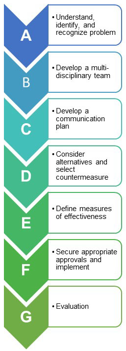
Figure 2-1 – Steps to develop a successful
speed management plan for
rural communities
Speeding is a persistent issue faced by all transportation agencies intent on balancing the mobility and safety needs of roadway users within a community. It can be especially acute in rural communities that may not have the staffing or dedicated resources to proactively address roadway design and operational issues that encourage speeding. It is common for these communities to face speeding-related safety issues at both the entrance and exit to the community, as well as within.
This section provides some planning considerations for rural communities to address speed-related safety issues and is adapted from the policies and plans of a number of agencies (DelDOT, 2012; PennDOT, 2012; PennDOTand NJDOT, 2008; VAT, 2003; VDOT, 2002). This information, as illustrated in Figure 2-1, is intended to support decision-making and serve as a supplement to existing policies or procedures. It not intended as a replacement for local, county, or state guidelines or requirements.
The first step in addressing potential speeding issues is to determine whether a safety problem due to speeding actually exists. Citizen reporting can be an effective beginning point towards this end; however, this type of reporting is often subjective or limited in scope, while solving a speeding problem and choosing where to invest critical resources requires quantifying the problem more objectively. To this end, speed and crash data should be considered in determining the magnitude of the problem faced and the possible influencing factors. For example, are motorists speeding all the time, or is this a periodic issue (e.g., seasonal, day of week, time of day)? What percentage of vehicles exceed the posted speed limit by 5, 10, or 15 mph? Are there reported crashes within the area of influence? If so, when did these happen, what types of crashes were they, and how often did they occur? Is there pedestrian and/or bicyclist activity? The practitioner should keep in mind that a lack of reported crashes does not automatically mean there is no safety problem.
2.1.1 Gather Necessary Data
Understanding the magnitude of a potential speeding problem requires the collection of basic information about the roadway environment, including vehicle speeds, volumes, and safety performance over time. Physical information about the roadway and its adjacent right-of-way (ROW) is also important to collect and consider so that appropriate countermeasures can be selected, if it is determined that a speeding problem exists. In addition to a site visit, it is important to determine what data might already be available for review. Typical data needed for review include the following:
2.1.1.1 Functional Class
The functional class of a roadway corresponds to the character of service that it is intended to provide. Higher-functional class roadways typically have higher speed limits and are designed to convey higher volumes of traffic, traffic over longer distances, larger vehicles, or some combination of the aforementioned. Since the main road through many rural communities is often considered to be a principal arterial (one of the highest functional classes) outside of the community, the practitioner should strive for a posted speed limit that first and foremost ensures safety of all roadway users, while minimizing delay for what is often the dominant user group passing through a rural community: motorists. For more information on roadway functional class see: Highway Functional Class Concepts, Criteria, and Procedures.
2.1.1.2 Traffic Volume
The most common measures of traffic volume are annual average daily traffic (AADT) or average daily traffic (ADT). Especially within rural communities, understanding the percentage and types of large trucks and agricultural vehicles served is important in understanding compliance with posted speed limits, starting/stopping performance, and in considering the suitability of speeding countermeasures and traffic control devices. Quantifying the traffic demands during peak travel periods, such as morning and afternoon commute hours, or beginning and end times for local industry and schools, is also helpful in understanding the extent of a speeding problem in terms of pressure on the roadway performance and capacity. Additionally, pedestrian and bicycle volumes are important, along with transit access points, for considering vulnerable user exposure times and high-risk interaction points along a roadway.
2.1.1.3 Speed Data
Quantifying the degree to which motorists are out of compliance with posted speeds is critical in addressing citizen concerns, determining actual problem areas, considering appropriate speeding countermeasures, and investing in and monitoring community safety over time. Spot speed data are measured at a specific point along a roadway, as opposed to average speed data, which are collected over a longer roadway segment. Some agencies regularly collect speed data either through sensors along the roadway, deployment of speed trailers, law enforcement, or newer means such as third party probe vehicle data providers.
In cases where speed data is not available speeding issues may also be identified through examination of physical evidence on the roadway, such as skid marks, rutting, and worn centerline markings (Bagdade et al. 2012).
2.1.1.4 Area of Influence
When agencies deploy speeding countermeasures, it is also important to consider the geographic area that will be affected. This entails consideration of the area where the speeding problem occurs and then focusing countermeasures to that location. Selection of countermeasures should consider the impact on surrounding streets. In some cases, countermeasures may divert traffic to adjacent roadways which may not be designed to handle the higher volumes, and may pass through even more sensitive residential areas. In addition to the diversion, speeds may increase on these adjacent roadways if drivers attempt to "make up time."
Example: Residents in a rural community tell local leaders that speeding is an issue on First Street, the main thoroughfare through town, so city officials install speed humps to correct the problem. Now the residents on Second Street are complaining that both traffic and speeding have increased due to diverting vehicles, and are demanding a solution. City leaders are left chasing the speeding issue through the community, which can quickly consume limited time and financial resources.
Like water searching for the path of least resistance, addressing speeding issues requires some planning and consideration of the area influenced by both the problem and countermeasures considered. Otherwise, unintended consequences may result from the deployment of countermeasures in isolation.
2.1.1.5 Roadway Inventory
An inventory of the roadway's geometric design elements is important since some countermeasures are not appropriate for certain roadway environments. For example, speed tables/cushion/humps need to consider drainage when curb and gutter are present; otherwise, excessive pooling of water may occur near the installation. Physical characteristics collected typically include:
This list of roadway elements is not exhaustive by any means but reflects the types of data most commonly collected and readily available to rural transportation agencies with limited staffing and technological resources. For a comprehensive list of roadway inventory elements that can be collected when developing safety treatments and speeding countermeasures, refer to FHWA's Model Inventory of Roadway Elements.
2.1.1.6 Crash Data
Crash data should be gathered for the roadway segments within the study area. Since crashes– particularly on lower-volume rural roads–are random and rare events, several years of crash data are necessary to establish a pattern. At least five or more years of historic crash data is preferred for an analysis to reduce the impact of outlier years and account for any unusual or otherwise temporary conditions which may influence safety - when five years is not available, a minimum of three years of crash data is commonly used. The Iowa DOT, for example, requires five years of crash data to establish a crash pattern for consideration of safety improvement funding (Iowa DOT, 2017). Other agencies use three years of crash data to assess safety performance (LADOT, 2016; Florida DOT, 2017; FHWA, 2010). Information about individual crashes, such as crash severity (fatal, injury, or property damage only), date, time of day, time of year, weather conditions, type of crash, type and number of vehicles, vehicle movement, and primary/secondary contributing factors, can be used to determine if a speeding or other safety problem is present. Crashes involving pedestrians and bicyclists should be given especially careful consideration when determining if there is a speeding problem within the community.
Besides data on actual crashes, citizen complaints, reports from maintenance personnel, or law enforcement feedback can also be evaluated, since these groups may be aware of near misses or minor collisions that are not reported in crash databases (Golembiewski and Chandler, 2011). While such occurrences may not directly affect the safety of a community, they can be symptomatic of speeding issues within transition zones and town centers that have simply not yet manifested in a fatal or severe injury crash.
2.1.1.7 Other Information
Other information about the roadway that can affect, or would be affected by, speeding countermeasures may need to be collected. This includes information on winter and other maintenance activities, such as type of vehicles expected to be present (e.g., snow plow). Other characteristics include the presence and extent of on-street parking, locations of bike and pedestrian activity, school zones, and location of emergency service routes. It is also important to observe the operational conditions on-site during both peak and non-peak times. Other seasonal factors, such as large farm machinery that may occlude sight distances during certain times of the year, should also be taken into consideration whenever possible. This information can be cross-referenced with crash data, if available, to determine if there is a significant correlation between these travel periods, speeding behavior, and overall roadway safety.
2.1.1.8 Future Plans
Future roadway and land use plans for the adjacent area should be obtained and considered when identifying speeding issues and implementing countermeasures, since new development and roadway improvements may alter traffic patterns and volumes, as well as physical roadway characteristics. These changes can have impacts such as generating new local trips or pass-through traffic in a rural community, and in some cases can introduce alternate routes through an area, possibly exacerbating the unintended spillover effects of a speeding countermeasure. Near-term improvements, such as routine pavement maintenance, as well as larger maintenance projects, such as pavement reconstruction and rehabilitation, should also be considered. Such maintenance and construction activities can have effects such as generating temporary delay and congestion, or else resulting in temporary bypass routes, both of which can exacerbate or introduce speeding issues in a rural community.
2.1.2 Evaluate Data to Confirm Speeding Problem
Once field information is collected and observations made, an analysis of the information and data is critical in determining whether a speeding problem actually exists, and if so, its magnitude. Such an analysis will help identify and prioritize the problem locations and will aid the practitioner in selecting the most effective speeding countermeasures, such as adjusting the posted speed limit, adding compliant signage, or pursuing more intensive physical alterations to the roadway.
The first step is in the data evaluation process is to conduct a qualitative analysis to determine whether existing roadway characteristics, such as signage, are appropriate for the operating environment. For example, the locations being assessed should have all traffic control devices, signage, and pavement markings in compliance with the standards set forth in the Manual on Uniform Traffic Control Devices (MUTCD). The MUTCD provides the minimum standard requirements for traffic control devices on all public streets, highways, bikeways, and private roads open to public travel. Complying with MUTCD requirements can result in improved roadway operations as well as safety, and is generally a prudent first step before considering more intensive or focused countermeasures to address speeding issues in the transition zone or town center areas. Practitioners in rural communities should also contact their State Department of Transportation (DOT) for their standards on roadway design, signage, and traffic control, as often they are more stringent than the requirements in the MUTCD.
If the traffic control devices on the roadway segment do not comply with the MUTCD, or the agency or State DOT minimum requirements, appropriate devices should be installed in their place. When these devices are intended to address speeding issues, they typically include:
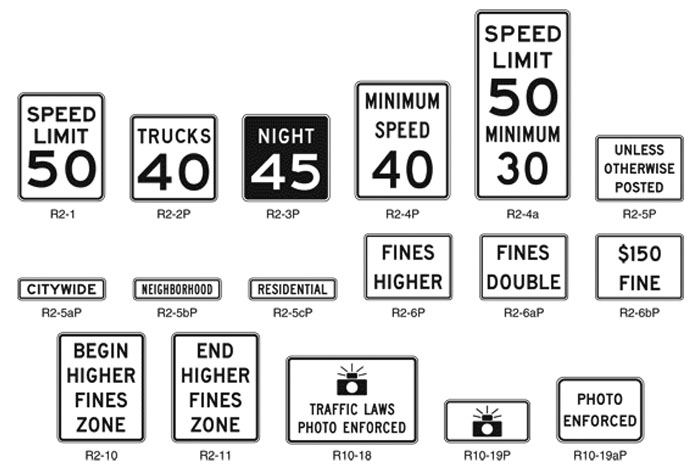
Figure 2-2 Examples of speed limit and photo enforcement signs and plaques. Source: Figure 2B-3, 2009 MUTCD
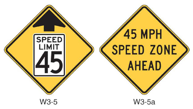
Figure 2-3 Reduced speed limit ahead signs. Source: Figure 2C-7, 2009 MUTCD
Road Safety Audits (RSA) are also used to qualitatively assess the safety of a roadway segment or corridor. Additional information on RSA is provided in Chapter 3. RSAs may assess the suitability of roadway design features such as lane width, use of curb and gutter, grade, and curvature. RSAs also include observations relative to visible safety indicators, such as skid marks or crash debris.
Besides ensuring that individual signs, pavement markings, and traffic control devices are MUTCD-compliant, agencies should also ensure that the transition zones entering the rural community are appropriately set. More detailed guidance on setting transition zones is provided in Chapter 4.
A quantitative analysis is used to determine whether a speeding issue exists and primarily entails analyzing speed or crash data to determine how travel speeds and crash frequency/severity compare, relative to surrounding roadways. Techniques for conducting an analysis of speed data include performing speed studies and comparing common speed metrics, such as mean or 85th percentile speeds, to posted speed limits. The metrics and techniques are described more thoroughly in Chapter 3. Similarly, a crash analysis is used to determine the extent of the speeding issue, the priority for the application of scarce resources, and selection of appropriate countermeasures. Some basic performance measures that can be used for a preliminary crash analysis are comparison of crash frequency and crash rates, although whenever possible, more comprehensive resources (such as FHWA's Roadway Safety Data Toolbox) should also be consulted. Additional information about conducting crash analyses can also be found in Chapter 3.
2.1.3 Taking a Proactive Versus Reactive Approach
A proactive approach to speed management focuses on eliminating speeding problems before they have a chance to result in serious injuries or fatalities, while a reactive approach is based on responding to events, especially crashes, after they have occurred. The difference between these two approaches is the perspective each one provides in assessing actions and events. It is common for communities, regardless of size, to be working from a reactive approach where speeding issues are identified by staff, citizens, or following a unique event. While this approach is well-established in practice, it can never (by definition) eliminate all speeding-related crash injuries and fatalities. It may also have the unintended consequence of forcing the hand of local officials to "do something" in response to a crash or other safety event, even when the action has little chance of substantive impact.
By contrast, communities that have developed proactive approaches to speed management often have a range of policies in place to address speeding issues, beginning with the least intrusive and increasing in intensity, complexity, and cost as the problem persists. These communities also frequently have established processes to solicit residential buy-in, and sometimes financial support, for speeding countermeasures. FHWA has developed a comprehensive list of tools, case studies, and risk factors to consider when developing a proactive approach to speed management, wherein the techniques are collectively referred to as a "systemic approach top safety." More information on this resource can be found on the FHWA's Office of Safety website for Systemic Safety.
In addition, the establishment of a proactive approach to speed management can be beneficial in addressing community growth issues with developers, prior to zoning changes and project approval. One common issue for rural communities occurs when development takes place just outside of a well-established community boundary. In these cases, issues with traffic operations and speeding may not occur for several years until a sufficient amount of development has occurred. A proactive approach considers the changing nature of the land use and sets in place policies and design requirements that mitigate potential speeding and other safety issues before they occur.
2.1.4 Addressing a Problem Spot Versus Segment
Speeding countermeasures may be selected for a specific location (spot improvement) or applied on a longer segment (segment improvement). Determining which to use should be driven by the data collected and a knowledge of existing or planned influencing factors. For instance, using a segment-based approach, speeding countermeasures could be applied along the length of a transition zone to a rural community to inform drivers that roadway and land use characteristics are changing. Additional treatments could then be applied within the community to reinforce and maintain appropriate speeds. A segment-based approach may avoid the aforementioned problem of speeding issues spilling over into adjacent streets (DelDOT, 2000). A spot-based approach, by contrast, would only apply a countermeasure at the location exhibiting a speeding or crash problem.
The advantage to a segment-based approach over a spot improvement is that speeding and acceptable operating speeds are addressed more consistently throughout the community. The segment-based approach mitigates the issue of drivers slowing down for a countermeasure, and then speeding back up once they are past the location. On the other hand, a spot-based approach has the advantage of requiring fewer countermeasures, which can result in lower installation and maintenance costs, and can mean the difference in whether or not any countermeasures are implemented, particularly for resource-constrained agencies. Additionally, assessing the effectiveness of speeding countermeasures is more straightforward and pronounced when using a spot-based approach, as those roadway segments beyond the area immediately adjacent to the treatment do not typically exhibit long-term changes in driver characteristics.
2.1.5 Issues and Challenges
For the numerous rural communities across the U.S., the ability to address speeding concerns can be a real challenge given a lack of staff to help quantify the problem and determine effective countermeasures.
Beyond basic staff capabilities, one challenge frequently encountered when addressing speeding issues is jurisdiction of the roadway in question. In many cases, the main street through a small community is also a State- or county-owned road. As a result, selecting and implementing speeding countermeasures must be coordinated with the agency that maintains ownership jurisdiction. In some cases, the practices of the ownership agency may differ from the desires and goals of the individual community; this can be especially common with larger agencies, such as a DOT that oversees roads for an entire State, including a mix of urban, suburban, and rural areas. To mitigate any jurisdictional issues, rural communities should involve these stakeholders early in the planning process to ensure coordination, agreement in priorities and practices, and potentially make use of any available funding opportunities.
Speed management planning also requires the consideration of all users of the system, such as bicyclists and pedestrians. In some cases, it can be challenging to select speeding countermeasures that address multiple priorities. For instance, a speed table within a community may provide a natural crossing point for pedestrians but presents an obstacle for bicyclists. Additionally, it is difficult to consider the needs of pedestrians and bicyclists when they are discouraged from using the system by current conditions. In these cases, an agency may have difficulty determining whether or not a low pedestrian or bicyclist count is simply due to low demand, or also due to user discomfort on the roadway. Implementing speeding countermeasures that make the roadway safer and more comfortable for vulnerable users may result in an unexpected increase and pedestrian and bicyclist volumes, which practitioners should be cognizant of when selecting specific treatments and prioritizing resources to address speeding issues.
Community approval is one of the most important steps in a speed management program (PennDOT, 2012) and is best addressed with a multidisciplinary team approach, which ensures a community is well represented and all issues and opportunities can be identified. A multidisciplinary team is one that includes a range of stakeholders with different backgrounds, interests, and experiences. It ensures the solution fits the community's need. The team should be developed based on the specific problems being addressed. Typically, a multidisciplinary team includes the following groups (VDOT, 2002; PennDOT and NJDOT, 2008) shown in Table 2-1. Due to resource and practical constraints, a multidisciplinary team differs by community size.
Generally, the team can assist with identification and selection of countermeasures, reviewing effectiveness later in the process, and providing feedback about community goals. The team should also encourage collaboration and coordination between different agencies such as law enforcement and city councils; and assist in identifying right-of-way-issues and potential funding sources (VAT, 2003). Additionally the team can provide information such as future business plans or law enforcement initiatives that may need to be considered.
While the team should review and approve of the final speed management plan, it should also be recognized that approval outside of the team may be needed from local, county, and State agencies.
Table 2-1 Potential Multidisciplinary Team Members
| Suburban Fringe | Small Rural Village | |
|---|---|---|
| Emergency Services |
|
|
| Public |
|
|
| Government |
|
|
A communication plan should be developed in coordination with the multidisciplinary team for most projects to ensure the community is provided the opportunity to participate and provide feedback (PennDOT and NJDOT, 2008). The plan should consider all issues that are likely to arise during the course of the project, including after initial installation of any speeding countermeasures.
Agencies and the public should be provided an opportunity to comment as early as practical in the decision-making process (PennDOT and NJDOT, 2008). Initial community meetings are held to encourage participation by community leaders, residents, local politicians, law enforcement, fire and emergency personnel, and county and State officials (VDOT, 2002). Local officials typically arrange the meeting and determine the scope. The objectives are to educate the public about the problem and issues involved, learn more about the concerns of the community, and work together to identify solutions. A list of items that may be discussed include:
The communication plan includes a method to update the community throughout the process. Staging and timeline should also be communicated. Ongoing communications can be achieved through additional meetings, newsletters, focus groups, press releases, websites, workshops, etc. (VAT, 2003).
An initial set of countermeasures can be identified by taking the following into consideration:
Once an initial set of countermeasures is identified, a point system or other method to weight each countermeasure can be used to prioritize selection (Bagdade et al., 2012). However, a final solution should be a collaborative effort rather than a vote (PennDOT and NJDOT, 2008). Factors to consider in selection include:
Speeding countermeasures involving signs, pavement markings, and or other traffic control devices should meet MUTCD criteria, or an exemption should be obtained. A comprehensive list of countermeasures for consideration is provided in Chapter 4.
Additionally, selection of countermeasures must address emergency medical services (EMS) and emergency response needs. A community should identify all potential EMS and determine the type of equipment likely to be used as well their needs in accessing emergency situations. As noted in Section 2.2, they should be included in the planning process to ensure they are allowed to provide feedback at early stages in the process.
Countermeasures should be periodically evaluated to determine whether they are effective. Measures of effectiveness (MOE) should be determined during the planning phase and should be available from practically available data. MOEs should be related to project needs and objectives. Additionally, MOEs should be understandable to the non-technical public. For instance, if the main objective is speed reduction, an appropriate MOE is reduction in mean or 85th percentile speed. Typical MOEs include:
For MOEs to be computed and effective comparisons to be made, speed, crash or other data need to be collected both before and after installation of countermeasures.
Once countermeasures have been selected, the appropriate approvals and permits need to be obtained. Once this is accomplished, the countermeasures are implemented.
Selecting an appropriate countermeasure requires an understanding of the permits or approvals necessary by the relevant roadway authority whether that be DOT, county, or city/village. The selection process should also consider input from critical users including the fire, police, and local emergency responders. Countermeasures which affect existing utilities, or right-of-way, must be thoroughly considered with the relevant impacted entity. Input from residents and businesses impacted by the countermeasures should be part of the process used to identify the multidisciplinary evaluation team described in section 2.2.
The final step is evaluation of the countermeasures to ensure they are effective. In some cases, improperly installed countermeasures can create a safety hazard and require modification or removal. For instance, drivers may divert their path into oncoming traffic to avoid a speed hump. Most countermeasures require some long-term maintenance, so if the agreed-upon MOEs deem them ineffective, removal may be considered rather than continuing to invest resources.
Several different types of evaluations can be conducted. Short-term evaluations should be based on changes in speed or volume, in addition to a survey of residents, survey of businesses, or assessing changes in pedestrian/driver behavior. Speed and volume data should be collected at least one month after the countermeasures are installed so that traffic patterns have stabilized. Several agencies suggest monitoring speed and volumes for six months to one year (PennDOT, 2012; VAT, 2003). The New York State DOT suggests monitoring diversion of traffic from the route receiving the speed countermeasure to adjacent routes to ensure they are not adversely impacted (NYSDOT, 1999).
Crash analyses require a longer evaluation period after the countermeasure is installed to accurately identify long-term trends. Typically, crashes are monitored 3 to 5 years after installation. Chapter 3 discusses speed and crash analyses which can be used to evaluate countermeasures.
2.8.1 Speed Management Toolbox for Rural Communities
Source: www.intrans.iastate.edu/research/documents/research-reports/rural traffic calming toolbox w cvr.pdf
Year: April 2013
Publisher: Institute for Transportation at Iowa State University
Description: The primary objective of this toolbox is to summarize various known speed management countermeasures and their effectiveness. This toolbox focuses on roadway-based countermeasures for speed management which are appropriate for rural communities with transition zones. The research team identified treatments based on their own research, a review of the literature, and discussion with other professionals. This toolbox describes each treatment and summarizes placement, advantages, disadvantages, effectiveness, appropriateness, and cost for each treatment. The categories of treatments covered in this toolbox include: horizontal physical displacement, vertical physical displacement, narrowing, surroundings, pavement markings, traffic control signs, and other strategies.
2.8.2 Speed Management: A Manual for Local Rural Road Owners
Source: www.safety.fhwa.dot.gov/local_rural/training/fhwasa010413spmgmt
Year: November 2012
Publisher: Federal Highway Administration (FHWA-SA-12-027)
Description: The manual provides an overview of the consequences of speeding, describes speed metrics, outlines a speed management process, identifies sources of data, discusses appropriate speed limits, and summarizes categories of countermeasure including enforcement.
2.8.3 Main Streets: Flexibility in Design and Operations
Year: January 2005
Publisher: California Department of Transportation
Description: The handbook focuses on speed management on State highways that serve as local main streets. It discusses community involvement, partnerships, and performance measures. A list of countermeasures appropriate to State highways is included.
2.8.4 Delaware Traffic Calming Design Manual
Year: 2012
Publisher: Delaware Department of Transportation
Description: The document outlines the process for conducting speed management including public involvement, project approval, implementation, and countermeasures. In particular, the document describes a priority rating system that weights factors used to determine where to prioritize resources.
2.8.5 Smart Transportation Guidebook
Source: http://www.state.nj.us/transportation/community/mobility/pdf/smarttransportationguidebook2008.pd f
Year: March 2008
Publisher: Pennsylvania and New Jersey Department of Transportation
Description: The guidebook takes a smart transportation approach to planning and designing roadways. Although it focuses on design, many of the principles are applicable to speed management and a section specific to speed management is included. It contains common elements in other guidebooks such as developing a multidisciplinary team, community involvement, collecting and analyzing data, and considering alternatives. Additionally it summarizes common performance measures that can be utilized to select alternatives and measure outcome. The guidebook also discusses how land use (i.e. rural, suburban, and villages), roadway (i.e. principal arterial, collector, village main street), and network characteristics can be considered in the process. The guidebook also addresses transition zones.
2.8.6 Traffic Calming Study and Approval Process for State Highways
Year: September 2003
Publisher: Vermont Agency of Transportation
Description: The guidance provides information for planning, evaluating, and implementing speed management projects on state highways. The speed management process is outlined and appropriate devices for state highways are summarized. Application of countermeasures according to location is provided which includes rural, transition, and village. A method for ranking projects is also included which can be used to prioritize projects or evaluate needs.
2.8.7 Traffic Calming: State and Practice
Source: http://www.ite.org/traffic/tcstate.asp
Year: 1999
Publisher: Institute of Transportation Engineers
Description: This informational report provides an overview of traffic calming, discusses impacts, legal authority and liability, addressing emergency response, project selection and public involvement, and synthesizes traffic calming experiences in the United States and Canada. The primary focus is residential areas and locations where high speed rural highways transition into rural communities.
2.8.8 U.S. Traffic Calming Manual
Source: https://www.routledge.com/US-Traffic-Calming-Manual/Ewing/p/book/9781932364613
Year: 2009
Publisher: Routledge
Description: The manual provides guidance on the appropriate use, design, signing, and marking for traffic calming countermeasures. The guidance attempts to bring standardization to traffic calming programs.
2.8.9 Effective Application of Traffic Calming Techniques. Caltrans Division of Research and Innovation
Year: September 2011
Publisher: California Department of Transportation
Description: The report summarizes traffic calming guidance from several States. The report summarizes background, traffic calming policies, types of treatments, and legal issues. It also summarizes research for several types of traffic calming treatments including horizontal treatments, vertical treatments, road narrowing/road diets, and rural/urban transition zones.
2.8.10 Toolbox to Address Safety and Operations around Schools in Iowa
Source: www.intrans.iastate.edu/research/projects/detail/?projectID=-73529932
Year: August 2006
Publisher: Institute for Transportation at Iowa State University
Description: The toolbox was developed from a summary of literature, field observations, interviews and data collected from elementary and middle schools in Iowa. Each chapter of the toolbox is presented in a user-friendly format that includes many photos to illustrate both problems and solutions to transportation safety and operation issues that exist at the schools in Iowa. The visuals within the handbook include photos and sample data forms that are useful for schools and traffic safety steering committees and traffic professionals. Important industry-recognized documents are also referenced throughout the chapters to ensure that the schools are aware of the guidelines and standards available. Although not specifically related to speed management, it does deal with addressing safety for schools which is applicable to rural villages.
2.8.11 Jurisdiction Speed Management Action Plan Development Package
Source: www.safety.fhwa.dot.gov/speedmgt/ref mats/docs/fhwa speedmanagementpackage final.pdf
Year: January 2015
Publisher: Federal Highway Administration (FHWA-SA-15-017)
Description: The document contains a speed management action plan which agencies can to use develop speed-management safety action planes. It also includes a summary of expected crash or speed reduction impacts for a variety of countermeasures. Examples of speed action plans are also included.
Bagdade, Jeffrey, Dan Nabors, Hugh McGee, Richard Miller, and Richard Retting. Speed Management: A Manual for Local Rural Road Owners. FHWA Office of Safety. FHWA-SA-12-027. November 2012.
DelDOT. Final Regulations 528. Delaware Department of Transportation, Division of Planning and Policy. Delaware Register of Regulations, Vol. 4, Issue 3. September 1, 2000.
DelDOT. Delaware Traffic Calming Design Manual. Delaware Department of Transportation. 2012. https://nacto.org/wp-content/uploads/2015/04/DE-Traffic-Calming-Manual_2012.pdf
FHWA. Roadway Safety Information Analysis: A Manual for Local Rural Road Owners. Federal Highway Administration, Office of Safety. December 2010. https://safety.fhwa.dot.gov/local_rural/training/fhwasaxx1210/index.cfm
Florida DOT. High Risk Rural Roads Listing for Local Roads. Accessed April 2017. fdotewp1.dot.state.fl.us/trafficsafetywebportal/docs/SAFETEA-LU - Analysis Reports Specification.pdf.
Golembiewski, G.A. and B. Chandler. Intersection Safety: A Manual for Local Rural Road Owners. Federal Highway Administration, Office of Safety. FHWA-SA-11.08. January 2011.
HA. Design Manual for Roads and Bridges. Volume 6, Part 5: Traffic Calming on Trunk Roads: A Practical Guide. The Highways Agency, Scottish Executive, Welsh Assembly Government, the Department for Regional Development Northern Ireland. TA 87/04.
Iowa DOT. Iowa SICL Method. https://www.iowadot.gov/crashanalysis/SICL20082012.aspx. Accessed April 2017.
LADOT. Guidelines for Conducting a Crash Data Analysis using the Number-Rate Method and Overrepresented Determination. Louisiana Department of Transportation. January 2016. wwwsp.dotd.la.gov/Inside_LaDOTD/Divisions/Multimodal/Highway_Safety/Misc Documents/Guidelines for Crash Data Analysis using the Number-Rate Method and Overrepresentation - Jan 2016.pdf.
Maine DOT. Maine DOT Guidelines for Use of Traffic Calming Devices. www.maine.gov/mdot/completestreets/docs/Guidelinesfortrafficcalmingupdated9711.pdf. Accessed April 2017.
NYSDOT. Highway Design Manual, Chapter 25–Traffic Calming. Revision 36. New York State Department of Transportation. February 5, 1999.
Oregon Department of Transportation. Traffic Manual 2016. January 2016.
PennDOT. Pennsylvania's Traffic Calming Handbook. Pennsylvania Department of Transportation. Pub 383. July 2012.
PennDOT and NJDOT. Smart Transportation Guidebook. Pennsylvania and New Jersey Department of Transportation. March 2008.
VAT. Traffic Calming Study and Approval Process for State Highways. Vermont Agency of Transportation. September 2003. vtransplanning.vermont.gov/sites/aot_policy/files/documents/planning/TrafficCalming.pdf
VDOT. Traffic Calming Guide for Local Residential Streets. Virginia Department of Transportation, Traffic Engineering Division. Richmond, Virginia. October 2002, revised July 2008.
Wemple, Elizabeth and Timothy Colling. Improving Safety on Rural Local and Tribal Roads. Federal Highway Administration. FHWA-SA-14-072. August 2014. safety.fhwa.dot.gov/local_rural/training/fhwasa14072/index.cfm#toc.
| << Module 1 | Rural Transition Zones ePrimer | Module 3 >> |

