U.S. Department of Transportation
Federal Highway Administration
1200 New Jersey Avenue, SE
Washington, DC 20590
202-366-4000
This section serves to support decision making when considering speed-related traffic calming countermeasures in rural communities. The information is focused on slowing traffic at the community transition zones and town centers, as well as along other rural commuter corridors through town.
Small, rural communities are often located along major state or county highways. Because of this, much of the traffic on the main roads through these communities is pass-through, rather than local, traffic. Managing this traffic, particularly the speed of this traffic, is important to the quality of life in the community. These major state or county roads that intersect these towns are characterized by high speeds outside the city limits and reduced speeds within the rural communities. However, drivers passing through the communities may enter at high speeds and then maintain those speeds as they pass through the towns, especially where there are no stops required. Travelers who use high rates of speed through town present safety issues for community members and discourage bike riding and walking; two of the only viable transportation modes for community members who are not driving. High-volume traffic traveling at high speeds also discourages community interaction and diminishes the quality of life for community members. Therefore, in order to maintain their viability, small communities need sustainable transportation systems.
Table 5-1 presents the applicability of each individual traffic calming measure and the likelihood of its acceptability within a rural small community setting. This table is based in part on the more complete list which can be found in the FHWA Traffic Calming ePrimer.
The table can be used for screening and is presented in terms of the location (intersection or roadway segment), the applicable roadway area (transition zone or town center), and other critical attributes faced by rural communities which include suitability for winter maintenance, and ability to accommodate large agricultural equipment. It is critical to remember that the applicability of a particular traffic calming measure has as much to do with the problem to be addressed as it does the physical setting elements listed.
Table 5-1 Applicability of Traffic Calming Measure within Rural communities
| Traffic Calming Measure | Applicable Area within Small Rural Community | Acceptibility by Critical Function | ||
|---|---|---|---|---|
| Transition Zone | Within Community | Winter Maintenance | Agricultural Equipment | |
| Horizontal Deflection | ||||
| Lateral Shift | 5 | 5 | 5 | 5 |
| Chicane | 3 | 5 | 3 | 3 |
| Mini-Roundabout | 1 | 5 | 3 | 3 |
| Modern Roundabout | 3 | 3 | 3 | 3 |
| Vertical Deflection | ||||
| Speed Hump, Cushion, Table | 1 | 3 | 1 | 3 |
| Raised Crosswalk | 1 | 3 | 1 | 3 |
| Raised Intersection | 1 | 3 | 1 | 3 |
| Roadway Changes | ||||
| Median Island | 3 | 5 | 3 | 3 |
| Road Diet | 3 | 5 | 3 | 3 |
| Lane Narrowing | 3 | 5 | 3 | 3 |
| Traffic Control | ||||
| Horizontal Signing | 5 | 5 | 5 | 5 |
| Speed Feedback Signs | 5 | 5 | 5 | 5 |
| Gateway Treatments | ||||
| Gateway Signing | 5 | 5 | 5 | 5 |
| Landscaping | 5 | 5 | 5 | 5 |
Legend:
5–traffic calming measure may be appropriate
3–caution; traffic calming measure could be inappropriate
1–traffic calming measure is likely inappropriate
Managing traffic on the major roadways that intersect communities is an important component of a sustainable, rural transportation system. Effective speed management solutions must not only consider bikes, pedestrians, and school locations, but will need to work within the characteristics of each community. Some of the unique challenges faced within rural America are considered in the following sections:
5.3.1 Design Driver
The proportion of people over 65 years of age is higher in rural versus urban areas, and the numbers are expected to increase in the next decade https://www.ncbi.nlm.nih.gov/pmc/articles/PMC3615459/. Countermeasures must accommodate the perception and reaction times of older drivers in order to be effective and gain acceptance as a speed management strategy.
5.3.2 Agricultural Use
Heavy trucks, agricultural equipment, the agri-business community, commuters, and residents are all using the same rural roads within small communities. The wide variety of vehicle heights, widths, and operational attributes warrant careful consideration of speed countermeasures especially when new devices are placed within the roadway, restrict lane widths, limit overhead clearance, or require a departure from a linear travel path.
Rural communities are impacted by the seasonal planting and harvest demands in terms of higher volumes and more frequent large agricultural vehicle usage. Trips between fields and the Co-Op are always time-driven and critical to these users. Speed management countermeasures that do not reasonably accommodate all roadway users, during peak times, risk being damaged and rejected as a source of frustration. To this point, it may be appropriate to install temporary or seasonal traffic calming measures under certain circumstances. For instance, temporary channelizing devices could be placed instead of curbing and then removed during spring planting or fall harvesting times.
5.3.3 Winter Maintenance
Countermeasures must be considered in terms of accommodation to conduct normal winter maintenance (brine, salt, plowing) activities especially when treatments are physically within the road or modify the roadway alignment or cross-section. Expensive countermeasures are often damaged beyond repair after the first snowstorm due to a lack of planning and communication. These efforts are important given that snowplow responsibilities can vary within the same community between County/City/Private depending on the roadway. These different agencies rarely have similar equipment, or training, and regularly work under poor visibility conditions where anything on the roadway is suspect to being hit and causing damage to the truck, countermeasure, and/or injuring the operator or others.
5.3.4 Maintenance
Countermeasure effectiveness requires alignment between the maintenance required and the agencies capabilities. For instance, pavement markings are low-cost and easy to install but require regular replacement
5.3.5 Roadway Impact
Rural corridors play a critical role in community vitality, farm to market mobility, and overall identity. Given that it is often the connection between communities, it is important to consider the degree of impact any speed reduction countermeasure may have on these functions. Countermeasures that significantly alter mobility may not be acceptable on the relatively higher volume commuter type of roadway.
Seasonal weather and agricultural undertakings, like spring planting or fall harvest, can dominate the operating conditions of a rural roadway. Agencies should carefully consider how any speed reduction countermeasure accommodates these seasonal demands. Some conditions for installing a temporary or seasonal speed reduction countermeasure include:
The materials used for a temporary speed management countermeasure often include delineators, precast concrete or plastic curbing, removable rubber speed humps, precast or wood planters, rolled asphalt, pavement markings, tubular markers, and signage. Overall, the potential effectiveness of any speed reduction countermeasure is dependent on the above considerations as well as the design, material, and installation quality.
This section provides additional information specific to each of the speed reduction measures listed in Table 5-1.
A general note on the costs: a range of cost estimates for each treatment is presented via link back to the FHWA Traffic Calming ePrimer, and as noted in that resource, the estimates only include the costs of design, materials, and construction. Also as noted in the Traffic Calming ePrimer, the range of costs can vary quite significantly, depending on the context in which the treatment is applied. For rural communities in particular, some of the cost variance may be due to the following:
An Important Note on the Allowable Use of Treatments and Countermeasures
As stated in previous parts of the ePrimer, all signage and pavement markings installed by the agency in pursuit of traffic calming and speed management must be compliant with FHWA's Manual on Uniform Traffic Control Devices (MUTCD). For certain treatments which are not MUTCD-compliant, such as for colored pavement markings to complement horizontal signing–detailed below–an agency may request an experimentation waiver from FHWA to allow its installation. Only after this waiver is obtained should a non-compliant treatment be installed. For full information on the experimentation waiver request process, please refer to the relevant page on the MUTCD website here.
5.5.1 Horizontal Deflection
A horizontal deflection hinders the ability of a motorist to drive in a straight line by creating a horizontal shift in the roadway. This shift forces a motorist to slow the vehicle in order to comfortably navigate the measure. The following types of horizontal deflections are described in this document:
5.5.1.1 Lateral Shift
Definition
A lateral shift is a realignment of an otherwise straight street that causes travel lanes to shift in one direction. A typical lateral shift separates opposing traffic through use of a median island or pavement markings.
Purpose
The primary purpose of a lateral shift is to reduce motor vehicle speed along the street.
Applicability within a Rural Community
Transition Zone
A lateral shift can serve as an effective geometric clue for motorists who have travelled for miles through a rural setting and are approaching a community where lower speeds are required. A median island not only separates opposing traffic but can also be used to form a turn lane that prevents rear-end collisions between major street through and left turning traffic.
Town Center
Winter Maintenance
A properly designed lateral shift has minimal impact to snowplow activities.
Agricultural Equipment
A properly designed lateral shift has minimal impact to large agricultural equipment use.
Effectiveness
Cost
See https://safety.fhwa.dot.gov/speedmgt/ePrimer modules/module3.cfm#mod32
Example
Figure 5.1 provides an example of a lateral shift used on the western edge of Grimes, Iowa where westbound motorists approaching the community have been driving on a two-lane 55 mph rural setting roadway for nearly 30 miles. As these drivers approach the community edge, they are presented with a divided roadway warning and a lateral shift to the right.
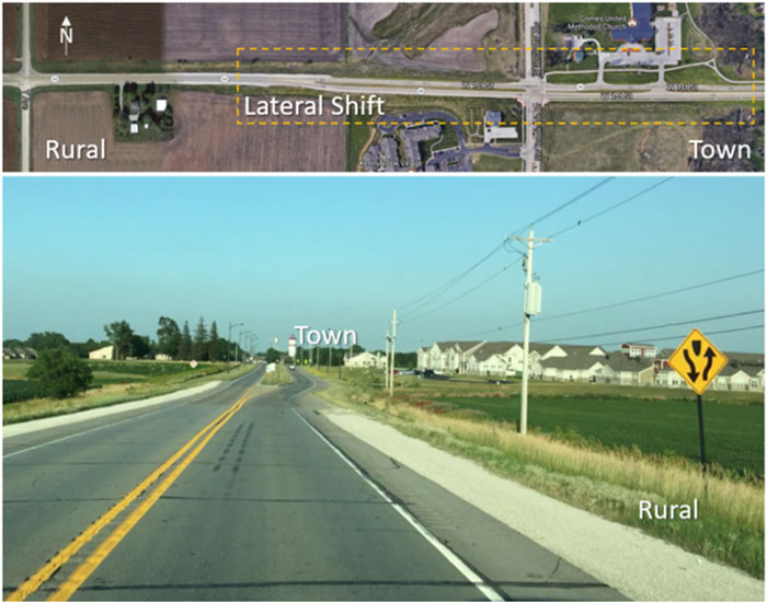
Figure 5-1 Lateral shift at transition from rural to town, Hwy 44 Grimes, IA
(Image Source: Google Maps, top; Neal Hawkins, bottom.)
5.5.1.2 Chicane
Definition
A chicane is a series of alternating curves or lane shifts located in a position that forces a motorist to steer back and forth out of a straight travel path.
Purpose
The curvilinear path is intended to reduce the speed at which a motorist is comfortable travelling through the feature. The lower speed could in turn result in a traffic volume reduction.
Applicability and Accommodation within Rural communities
Transition Zone
The chicane is not an ideal treatment when transitioning from high rates of speed as motorists approach the community.
Town Center
Chicanes are appropriate within the community where lower speeds prevail, however, these may be difficult for large trucks and agricultural equipment to negotiate if not properly designed.
Winter Maintenance
The sinusoidal nature of a chicane, along with the addition of either on-street parking or curb extensions, can impact the ability to remove snow and treat the roadway surface.
Agricultural Equipment
Careful consideration should be given towards the ability of a chicane segment to accommodate the range of oversized trucks and agricultural equipment which frequently travel through rural communities.
Effectiveness
Cost
One source indicated costs are $4,000 to $5,000 (Kastenhofer 1997). Another source indicated $4,000 to $8,000, depending on the length of roadway (CWS 2005). Temporary chicanes are also available. Use of pavement markings to create chicanes can be relatively inexpensive. NOTE: source for above from page 18: http://www.ctre.iastate.edu/reports/traffic-calming-rural.pdf
5.5.1.3 Roundabout
Definition
A roundabout is a circular intersection where traffic flows counterclockwise around a center island and vehicles entering yield to those already circulating. Each entry approach includes a horizontal deflection with an island and every vehicle is required to follow a circuitous path, no matter which departure leg of the intersection is the destination. As a result, traffic speeds are moderated and crash severity is reduced.
Purpose
Roundabouts improve traffic flow and safety through reducing the number and severity of conflict points and reducing vehicle speeds.
Applicability and Accommodation Within Rural Communities
Transition Zone
Properly designed roundabouts control speed and can be used at the transition from rural, high speed areas to low-speed urban environments. They can also serve as gateway treatments where land-use and speed limits change.
Town Center
Roundabouts are appropriate within the community where lower speeds prevail; however, they must be designed properly to accommodate the movements of large trucks and agricultural equipment.
Winter Maintenance
Roundabouts have been constructed in communities that experience significant annual snowfall. With minimal training and experience, local maintenance crews become very adept at snow and ice control at roundabouts.
Agricultural Equipment
Roundabouts are designed with aprons intended to accommodate the off-tracking of larger vehicles such as trucks and agricultural equipment which frequently travel through rural communities.
Placement
Roundabouts placed at intersecting roadways along the perimeter of a community and can reinforce a change in roadway setting for drivers and serve as an attractive community identity and aesthetic feature.
Effectiveness
See Traffic Calming ePrimer Cost
See: https://safety.fhwa.dot.gov/speedmgt/ePrimer modules/module3.cfm#mod32
5.5.1.4 Mini Roundabout
Definition
A mini-roundabout is small, circular, unsignalized intersection that relies on geometric features and yield control to achieve a balance between lower speeds, safety and operations. Mini-roundabouts are functionally similar to regular roundabouts, except the diameter is smaller and the raised central and splitter islands are traversable.
Purpose
The approach geometry, splitter island deflection and presence of the center island forces a motorist to reduce speed when entering and passing through the mini-roundabout, whether the vehicle path is straight through or involves a turn onto an intersecting street.
Applicability and Accommodation Within Rural Communities
Transition Zone
A mini-roundabout may be a worthwhile treatment to consider for a speed transition zone, but may require additional advance geometric features such as elongated splitter islands and chicanes.
Town Center
The traversable raised islands used at mini-roundabouts can accommodate the large trucks and agricultural equipment that are common in small rural towns.
Winter Maintenance
Mini-roundabouts have been constructed in communities that experience significant annual snowfall. With minimal training and experience, local maintenance crews become very adept at snow and ice control at mini-roundabouts.
Agricultural Equipment
The raised islands of mini-roundabouts are designed to be traversed by large vehicles, such as tractor-trailers, school buses, fire apparatus, and agricultural equipment. Consequently, landscaping and signage cannot be placed on these islands where the vehicle paths are intended.
Placement
Mini-roundabouts will usually work in lieu of traffic signals or stop signs. Typically, very little or no additional right of way is required. In scenarios where a mini-roundabout replaces an all-way stop-controlled intersection, there is a significant relief in congestion and delay, without sacrificing safety.
Effectiveness
Cost
See: https://safety.fhwa.dot.gov/speedmgt/ePrimer modules/module3.cfm#mod32
5.5.2 Vertical Deflection
A vertical deflection creates a change in the height of the roadway that forces a motorist to slow down in order to maintain an acceptable level of comfort. The types of vertical deflections described below in this document are:
5.5.2.1 Speed Hump, Cushion, Table
Definition
A speed hump is an elongated mound in the roadway pavement surface extending across the travel way at a right angle to the traffic flow.
A speed cushion consists of two or more raised areas placed laterally across a roadway.
A speed table is a raised area placed across the roadway designed to physically limit the speed at which a vehicle can traverse it.
Purpose
At typical travel speeds along a residential street or in a small commercial business district, these treatments produce sufficient discomfort to a motorist and discourage speeding. It encourages the motorist to travel at a slow speed both upstream and downstream of as well as over the treatment.
Applicability and Accommodation within Rural communities
Transition Zone
These traffic calming measures are inappropriate within a transition zone given the high variability of vehicle speeds.
Town Center
These vertical deflection treatments can be appropriate within the community where lower speeds prevail if the design accommodates all roadway user vehicle types.
Winter Maintenance
These types of treatments may impact snow removal if the plow blade does not smoothly transverse the surface.
Agricultural Equipment
Careful consideration should be given towards the nuisance and impact that a vertical deflection treatment has on the range of oversized trucks and agricultural equipment road users. These types of treatments may be more suited to collector roadways as opposed to where the highway is also serving as a Main Street.
Placement
The Delaware Department of Transportation (DelDOT, 2000) established a set of guidelines describing when particular treatments should be installed. DelDOT does not recommend using speed tables for principal arterials. However, they do recommend using speed tables on minor arterials, collectors, and local roads where the daily volume is less than 10,000 vehicles per day (vpd) and the posted speed limit is not greater than 35 mph.
Effectiveness
A study by LRRB (Corkle et al. 2001) summarized information from other studies, reporting a 28 percent change in 85th percentile speed, a 15 percent change in average speed, and a 28 percent decrease in auto collisions from using speed tables. A previous study by the Center for Transportation Research and Education (CTRE) evaluated temporary speed humps and speed tables in three locations in rural Iowa communities. The speed hump and speed table were evaluated in the same location in each of the three communities. Average and 85th percentile speeds decreased at the location of the device by up to 9 mph and 10 mph, respectively (Hallmark et al. 2002). [Note: above info from CTRE Phase1] Also see Traffic Calming ePrimer
Cost
See: https://safety.fhwa.dot.gov/speedmgt/ePrimer modules/module3.cfm#mod32
Example
A speed hump was installed within Gilbert, Iowa which has a population of 987, see Figure 5-2. The main road through Gilbert is County Highway E-23, which is a two-lane roadway (ADT ~1,500) oriented east/west through the middle of the community. The speed table was successful in decreasing speeds for all speed metrics, both immediately upstream and downstream of the speed table for each of the 3, 9, and 12 month after installation measurements. Several residents complained because they did not like the speed table; however, the community decided that the overall speed management benefits outweighed this perceived negative impact, and the speed table was allowed to remain in place.
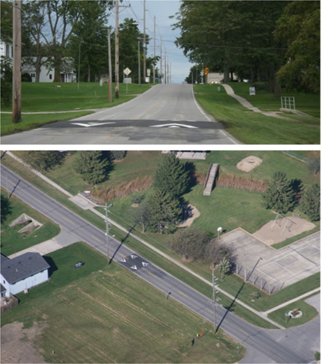
Figure 5-2 Speed hump installation in Gilbert, IA (Image Source: Hallmark et al. 2002)
5.5.2.2 Raised Crosswalk
Definition
A raised crosswalk is a variation of a flat-topped speed table which is marked and signed as a pedestrian crossing. The 10-foot flat top on a typical speed table conforms to a desired crosswalk width.
Purpose
The purpose of a raised crosswalk is to slow vehicle traffic at the crossing to improve pedestrian safety.
Applicability and Accommodation within Rural communities
Transition Zone
The raised crosswalk is not an ideal treatment when transitioning from high rates of speed as motorists approach the community.
Town Center
These treatments are appropriate within the community where lower speeds prevail; however, these may be difficult for large trucks and agricultural equipment to negotiate if not properly designed.
Winter Maintenance
The additional raised crossing can complicate the ability to remove snow and treat the roadway surface.
Agricultural Equipment
Raised crosswalks can cause problems for agricultural equipment due to a lack of suspension (bucking back and forth and jarring of the trailers or carts in tow). These can be a nuisance for routine truck routes (field to CO-OP) and should carefully consider accommodating the range of oversized trucks and agricultural equipment, which frequently travel through rural communities. Any signs associated at the crosswalk should be set-back far enough to avoid being struck by wide agricultural equipment.
Placement
Raised crosswalks can be placed midblock or at an intersection. Effectiveness
Cost
See: https://safety.fhwa.dot.gov/speedmgt/ePrimer modules/module3.cfm#mod32
5.5.2.3 Raised Intersection
Definition
A raised intersection is a flat, raised area covering an entire intersection with ramps on all approaches. It is essentially a speed table that covers an entire intersection, including the crosswalks.
Purpose
The purpose of a raised intersection is to slow vehicle traffic through the intersection and to improve safety for pedestrians. It has the advantage of calming two streets at once.
Applicability and Accommodation Within Rural Communities
Transition Zone
The raised intersection is not an ideal treatment when transitioning from high rates of speed as motorists approach the community.
Town Center
These treatments are appropriate within the community where lower speeds prevail; however, these may be difficult for large trucks and agricultural equipment to negotiate if not properly designed.
Winter Maintenance
The additional raised roadway can complicate the ability to remove snow and treat the roadway surface and intersection area.
Agricultural Equipment
Raised intersections can cause problems for agricultural equipment due to a lack of suspension (bucking back and forth and jarring of the trailers or carts in tow). These can be a nuisance for routine truck routes (field to CO-OP) and should carefully consider accommodating the range of oversized trucks and agricultural equipment, which frequently travel through rural communities.
Placement
Raised intersections are more suited for dense urban areas at a signal controlled or all-way stop intersection.
Effectiveness
Cost
See: https://safety.fhwa.dot.gov/speedmgt/ePrimer modules/module3.cfm#mod32
5.5.3 Roadway Changes
A roadway change includes physical modifications to travelled way through modifying the available number of lanes, lane widths, or by separation between travel directions with paint or a physical median. These modifications can force a motorist to slow down in order to maintain an acceptable level of comfort. The types of roadway changes described below in this document are:
5.5.3.1 Median Island
Definition
A median island narrowing is a raised or painted island located along the street centerline that narrows the travel lanes at that location.
Purpose
The required change in alignment, in addition to the visual appearance of narrowed lanes, encourages most motorists to reduce their speed.
Applicability and Accommodation Within Rural Communities
Transition Zone
If used within a transition zone, the median island would most likely be used in combination with a lateral shift. Vehicle speed transition would need to be carefully considered as this may be the first obstacle encountered while still outside the community and could surprise motorists traveling at high speeds.
Town Center
These treatments can be appropriate within the community as long as the design accommodates all roadway user types.
Winter Maintenance
These types of treatments can impact snow removal operations due to low visibility conditions and can create a drifting affect under blowing snow conditions.
Agricultural Equipment
Careful consideration should be given towards the ability of oversized trucks and agricultural equipment road users to navigate any median island narrowed roadway section.
Placement
Medians can be a part of creating a lateral shift within the transition zone area. In the town center, a median island can be used to provide a pedestrian refuge island along a marked crosswalk.
Effectiveness
Cost
See: https://safety.fhwa.dot.gov/speedmgt/ePrimer modules/module3.cfm#mod32
5.5.3.2 Road Diet
Definition
A [road diet] is a reconfiguration of the roadway to encourage a more community-focused, "Complete Streets" environment. The most common application is the conversion of an undivided four-lane roadway to a three-lane roadway consisting of two through lanes and a center two-way left-turn lane. A center island may also be incorporated. In addition to the four- to three-lane configuration, other roadway reconfigurations, can also provide safety benefits and reduce speeding.
Purpose
The reconfiguration or reduction in the number of lanes permits the inclusion of facilities for other uses, such as bicycle lanes, sidewalks, pedestrian refuge islands, transit uses, and on-street parking.
Applicability and Accommodation Within Rural Communities
Transition Zone
In many cases, the road diet is not applicable to the transition zone given the rural two-lane road cross-section. However, a Road Diet may be used to incorporate a Median island or lane narrowing. The use of Roundabouts in conjunction with Road Diets are applicable at transition zones.
Town Center
These treatments can be appropriate within the community where the accommodation of a two-way left turn lane, bike lanes, etc. is desired. Careful consideration should be given to accommodating all rural road users, especially large agricultural equipment.
Winter Maintenance
These treatments are often times delineated using pavement marking paint which has limited impact on snow removal operations. Raised medians can impact winter maintenance and should be designed accordingly.
Agricultural Equipment
Careful consideration should be given towards the ability of oversized trucks and agricultural equipment road users to navigate any modified roadway section.
Placement
The treatment can be used along the length of a main road through a small community.
Effectiveness
Cost
See: https://safety.fhwa.dot.gov/speedmgt/ePrimer modules/module3.cfm#mod32
5.5.3.3 Lane Narrowing
Definition
Lanes can also be narrowed using pavement markings or removable vertical traffic control devices rather than permanent installations such as medians, curbing, or a road diet.
Purpose
The required change in alignment, in addition to the visual appearance of narrowed lanes, encourages most motorists to reduce their speed.
Applicability and Accommodation Within Rural Communities
Transition Zone
Lane narrowing, using pavement markings, can be appropriate within the transition zone. Use of removable traffic control devices depends on the roadway characteristics and operating conditions. If these devices are the first obstacle encountered when entering the zone, every effort should be made to not surprise motorists traveling at high rates of speed.
Town Center
These treatments are appropriate within the community.
Winter Maintenance
Pavement markings are typically impacted by snow plow operations which requires increased maintenance. Removable traffic control devices can impact snow removal operations due to a narrowed cross-section. These devices can be removed during the winter periods.
Agricultural Equipment
Pavement markings do not affect large vehicles. Careful consideration should be given towards the ability of oversized trucks and agricultural equipment road users to navigate narrowed lanes.
Placement
Lane narrowing with pavement markings can be used within the transition zone area. Within the community, lane narrowing using pavement markings or temporary traffic control devices can be used to create wider shoulders or a pseudo median. Side-street and driveway operations must be considered when placing either pavement markings or traffic control devices.
Effectiveness
Pavement Markings
Pavement markings were used to narrow the travel lanes in Roland, Iowa as shown in Figure 5-3. Minor reductions in 85th percentile speeds were noted within 3 months after installation, however, speeds were found to normalize in the longer term (Hallmark et al. 2002).
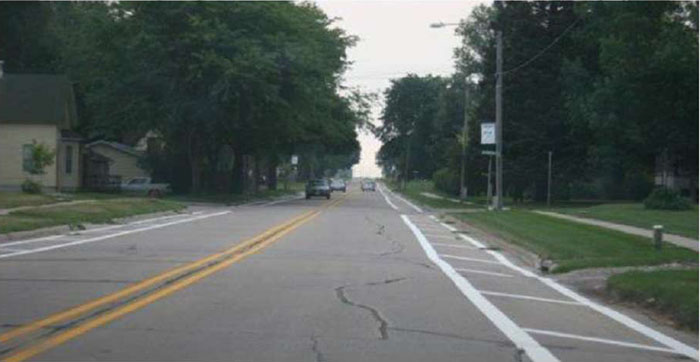
Figure 5-3 Pavement markings used to narrow lanes in Roland, IA (Image Source: Hallmark, et al. 2002)
Pavement markings were used to narrow the travel lanes at the transition area in Union, Iowa as shown in Figure 5-4. Median widening was used to narrow lanes to 11 feet for the northern treatment section. This section of SH 215 had a curb and gutter with a width of 40 feet curb to curb. An eight-foot center median island was created using pavement markings, and an eight-foot delineated shoulder was provided on the east side of SH 215 where parallel parking is allowed. This configuration narrowed the north and southbound lanes to 10 feet and 11 inches for the northbound lane and 12 feet and 9 inches for the southbound lane. The center island was not found to impact speeds, however, there were several concurrent countermeasures installed within the community (Hallmark et al. 2002).
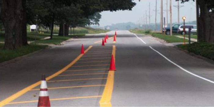
Figure 5-4 Pavement markings during installation of a painted center median to narrow lanes in Union, IA
(Image Source: Neal Hawkins)
Removable Traffic Control Devices
Lane narrowing, using temporary (or removable) traffic control devices, was used in two different communities. First, two center islands were created along the main road in Slater, Iowa using 36-inch longitudinal channelizers. A 25 mph speed limit sign was placed on a mountable sign support at the beginning of the center islands as shown in Figure 5-5. The 85th percentile speed decreased by 2 to 3 mph immediately (1-month) and up to 1 year after. The treatment did have to be removed during the winter months to allow snow removal. (Hallmark et al. 2013).
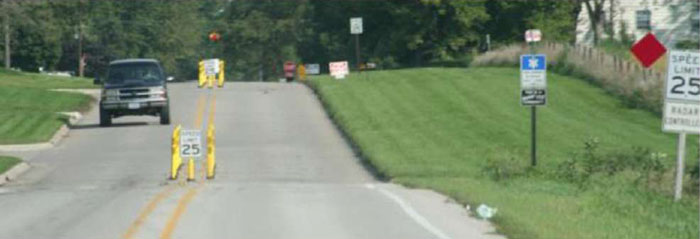
Figure 5-5 Removable traffic control devices used for lane narrowing, Slater, IA
(Image Source: Neal Hawkins)
Mountable curbing was used to create a small center island in St. Charles, Iowa as shown in Figure 5-6. The treatment was placed at the community entrances at three locations. Mean speeds decreased by 2 mph at 1-month after installation at two locations. Additionally, the fraction of vehicles traveling 5 or 10 mph over the posted speed limit decreased by 25 to 70 percent. Little change was noted at the third location (Hallmark et al. 2013). The treatment was removed during fall harvest since some farmers noted issues with agriculture equipment.
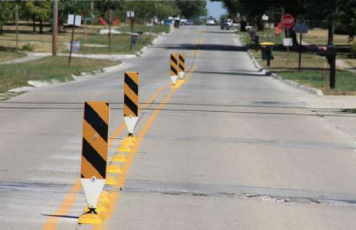
Figure 5-6 Removable traffic control devices used for lane narrowing, St. Charles, IA
(Image Source: Neal Hawkins)
Cost
Costs for pavement markings and channelizers, or other temporary traffic control, depends on the surface preparation required, the length of area treated, and the materials selected. In rural community settings, these are typically considered to be low-cost treatments.
5.5.4 Traffic Control
Traffic control includes a sign, signal, marking, or other device used to regulate, warn, or guide traffic, placed on, over, or adjacent to a street, highway, etc. This document does not include all the typical devices (stop, yield, traffic signal) used routinely within a community and is focused on two demonstrated effective speed management devices which are:
5.5.4.1 Horizontal Signing
Definition
On pavement signing typically includes speed-related markings on the pavement surface such as "SLOW" or "XX MPH."
Purpose
These pavement markings are intended to supplement existing signage and reinforce speed compliance by motorists. The oversized markings are more dramatic than static side-of-road signing which can get lost in the clutter of a streetscape.
Applicability and Accommodation within Rural communities
Transition Zone
These treatments are applicable to the transition area to alert motorists of the community boundary and speed transition required.
Town Center
These treatments can be used within the community at speed transitions or adjacent to critical areas such as a school or playground.
Winter Maintenance
These treatments do not affect winter operations; however, snowplows can cause significant damage to the pavement marking which increases maintenance considerations.
Agricultural Equipment
These treatments have no impact on agricultural equipment.
Placement
Speed limit legends are typically placed on the pavement in the same location as speed limits signs. On-pavement speed limit signs are considered supplemental and should not displace signing. Treatments within the wheel path should include a skid resistant material.
Effectiveness
Horizontal speed limit signage, within a large colored square, was applied at the community entrances for Dexter, Iowa (a small rural community) as shown in Figure 5.7. This treatment resulted in measured reductions of mean speeds up to 7.4 mph and in reductions of the 85th percentile speeds by up to 9 mph (Hallmark et al. 2002). Note: The red background coloring is not MUTCD compliant, and should only be installed after receiving approval from FHWA through an experimentation waiver. For more information on how to request such a waiver, please visit the MUTCD website.
![Figure 5-7 Horizontal signing at community entrance in Dexter, IA [Treatment authorized with MUTCD experimental waiver] (Image Source: Neal Hawkins). This photo shows an experimental treatment with 35 MPH painted in red on the road. Note: The red background coloring is not MUTCD compliant, and should only be installed after receiving approval from FHWA through an experimentation waiver.](images/rt25.jpg)
Figure 5-7 Horizontal signing at community entrance in Dexter, IA
[Treatment authorized with MUTCD experimental waiver]
(Image Source: Neal Hawkins)
In a followup study, CTRE evaluated this treatment at three additional community entrances in two rural Iowa cities (Hallmark et al. 2013). The treatment was first installed similar to the one shown in Figure 57. The findings showed that speed decreased at three sites with decreases up to 2.3 mph in mean speed. All sites had a decrease in 85th percentile speed of 2 mph. The fraction of vehicles traveling 5 or more mph over the posted speed limit decreased by 30 to 44 percent and the fraction of vehicles traveling 10 or more mph over the posted speed limit decreased by about 40 percent for all sites. A large decrease (up to 100 percent) resulted for the fraction of vehicles traveling 15 or more mph over the posted speed limit. No change was noted in the fraction of vehicles traveling 20 or more mph over the posted speed limit. After one year, dragon's teeth were applied as noted in Figure 5-8. However no further significant reductions in speed were observed (Hallmark et al. 2013).
![Figure 5-8 Horizontal signing at community entrance in Jesup, IA [Treatment authorized with MUTCD experimental waiver] (Image Source: Neal Hawkins). This photo shows an experimental treatment with 35 MPH painted in red on the road. Note: The red background coloring is not MUTCD compliant, and should only be installed after receiving approval from FHWA through an experimentation waiver.](images/rt26.jpg)
Figure 5-8 Horizontal signing at community entrance in Jesup, IA
[Treatment authorized with MUTCD experimental waiver]
(Image Source: Neal Hawkins)
Cost
Costs for pavement markings depends on the surface preparation required, the length of area painted, and the materials selected. In rural community settings, these are typically considered to be low-cost treatments.
5.5.4.2 Speed Feedback Signs
Definition
Speed feedback signs and displays are usually radar-activated signs that dynamically display approaching speeds for individual vehicles or display messages such as 'SLOW DOWN' or 'REDUCE SPEED' when a vehicle exceeds a certain speed. The devices can be portable or permanent and are sometimes referred to as dynamic speed feedback signs.
Purpose
The signs measure vehicle speeds and alert drivers that are not in compliance. The signs also create a sense of being monitored for speed compliance.
Applicability and Accommodation Within Rural Communities
Transition Zone
These treatments are applicable to a transition area to alert motorists of the community boundary and required speed compliance.
Town Center
These treatments can be used within the community at speed transitions or adjacent to critical areas such as a school or playground.
Winter Maintenance
These treatments do not affect winter operations.
Agricultural Equipment
These treatments have no impact on agricultural equipment.
Placement
Devices are placed in the location where a reduction in speed is desired. They may also be used in transition zones to slow traffic in advance of lower-speed areas.
Effectiveness
The Department of Transport, UK found that average speeds can be reduced by 1 to 7 mph using dynamic speed signs. The researchers also suggest that signs are more effective on a mobile basis, given drivers may become immune when the signs are installed on a permanent basis (Sustrans, 2005).
Three different dynamic speed feedback signs were evaluated in three different rural Iowa cities; Slater, St. Charles, and Rowley. (Hallmark et al. 2007, 2012).
Slater
A speed feedback sign with the capability of displaying different alphanumeric messages was installed on R-38 at the north community entrance next to West Elementary school, see Figure 5.9. After 3 months the mean speed had decreased by 5.4 mph with the 85th percentile speeds decreasing by 7 mph. The portion of vehicles traveling 5 and 10 mph over the posted speed was reduced by 49 and 26 percent respectively.
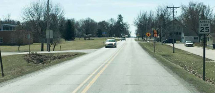
Figure 5-9 Speed feedback sign in Slater, IA
(Image Source: Neal Hawkins) St. Charles
A radar-actuated speed feedback sign, which had LEDs embedded around the outside of the sign, was installed and evaluated as shown in Figure 5-10. This sign was placed at the east community entrance along Iowa Highway 251 (West Main Street). The results showed a minor decrease in mean speed of 0.4 mph and no change in the 85th percentile speed. The portion of vehicles traveling 5 to 10 mph over the posted speed was reduced by 10 percent.
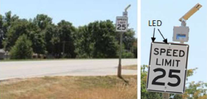
Figure 5-10 Speed feedback sign in St. Charles, IA
(Image Source: Neal Hawkins) Rowley
A radar-actuated speed feedback sign, which had a dynamic speed display, was evaluated as shown in Figure 5-11. This sign was placed at the west community entrance on County Road (CR) D-47 in Rowley, Iowa. The results showed a large decrease in mean speed of 8 mph and a similar decrease in 85th percentile speed of 9 mph one month after installation. The portion of vehicles traveling 5 and 10 mph over the posted speed was reduced by 45 and 73 percent respectively.
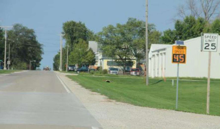
Figure 5-11 Speed feedback sign in Rowley, IA
(Image Source: Hallmark et al. 2013)
Cost
Dynamic speed signs can range in cost from $2,000-11,000 per display. 5.5.5 Gateway Treatments
Community gateway treatments are typically landscaped sign installations or overhead structures that announce to motorists that they are leaving the rural area and entering a community where land use, pedestrian, and motor vehicle activities will be more intense. Motorists should, in turn, respond by slowing down. The gateway treatments within this document are:
- Gateway signing.
- Landscaping.
5.5.5.1 Gateway Signing
Definition
Community gateways provide identity and are landscaped sign installations or areas that announce to motorists that they are entering a community.
Purpose
Gateway signs provide an indication to motorists that they are leaving a rural area and entering a city or town where land use, pedestrian, and motor vehicle activities will be more intense. The motorist should, in turn, respond by slowing down.
Applicability and Accommodation Within Rural Communities
Transition Zone
These treatments are applicable to the transition area to alert motorists of the community boundary and speed transition required.
Town Center
These treatments are not typically used within the community.
Winter Maintenance
These treatments do not affect winter operations.
Agricultural Equipment
These treatments have no impact on agricultural equipment.
Placement
Gateway treatments are typically close to the boundary of the community and to the right of the roadway, although some are so large that they span the roadway. The gateway needs to be large enough to attract the attention of drivers and it also must be formal enough so that it communicates the message that the character of the roadway is changing. Use of gateway entrance treatments should be consistent with clear zone requirements, since they are often made of immovable material that presents a fixed object hazard.
Effectiveness
The Department of Transport, UK, indicated that mean speed reductions of 3-13 mph, with an average of 5 mph, were achieved using gateways (Sustrans, 2005). It also reported that up to 15 mph speed reductions for the 85th percentile were achieved using gateways with other treatments (DETR 2005).
Cost
Community gateway treatment costs are highly variable depending on the scale and materials used. Figure 5-12 shows some example signage.

Figure 5-12 Gateway signage
(Image Source: Neal Hawkins)
5.5.5.2 Landscaping
Definition
Landscaping is often used in conjunction with other traffic calming treatments, such as raised medians or islands, chokers, roundabouts, traffic circles, and chicanes.
Purpose
Landscaping has two purposes: to make the traffic-calming treatment more attractive and to further communicate to the motorist that a slower speed is advisable.
Applicability Within Rural Communities
Transition Zone
In contrast to rural, planting alongside the road can communicate a change in the character of the roadway from rural to urban. The roadway appears narrower to the driver; the "optical width" of the road is narrowed as opposed to the "physical width." A "tunnel effect" is created and the driver's field of view is narrowed which, in turn, should encourage drivers to slow down. Slowing down is particularly critical in the transition zone where the largest decrease in speed is sought. The National Forest Service notes that trees planted at fairly regular intervals communicate a message that the street is "urban." NOTE: source for above from page 20: http://www.ctre.iastate.edu/reports/traffic-calming-rural.pdf
Town Center
Landscaping should be placed along the entire length of the street on both sides where traffic calming is desired.
Winter Maintenance
Minimal impact. However significant vegetation impedes snow storage.
Agricultural Equipment Minimal to no impact.
Placement
Trees will generally be the most effective form of landscaping in terms of traffic calming, due to the fact that they can grow large enough to provide the "optical narrowing" effect that should, in turn, reduce traffic speeds. Care should be taken in planting not to create additional driving hazards, such as less than adequate clear zone over the life of the tree, blocking sight distance triangles at driveways, and public road intersections. Agencies should also consider the maintenance required to ensure adequate sight distance over time.
Effectiveness
It is not clear from research literature whether landscaping alone will be sufficiently effective to calm traffic in the absence of other traffic-calming treatments, including physical treatments and enforcement. Landscaping should logically be used along with other traffic-calming treatments to achieve the desired result. It should be part of a comprehensive community traffic-calming plan.
Costs
Cost varies widely depending on the scale of the treatment and materials used. Example
Figure 5-13 shows an illustration out of the Route 206 Joint Vision Plan and Traffic Calming Study which takes a corridor level approach to finding solutions to local concerns. The Vision Plan contains a series of traffic calming elements (street trees, roundabouts, back-in angled parking, and pedestrian median refuges) designed to slow vehicular traffic and increase safe opportunities for pedestrians.
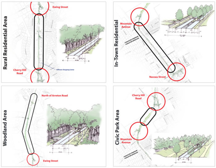
Figure .5-13 Vision scenarios for Cambridge, NJ
(Image Source: Route 206 Joint Vision Plan and Traffic Calming Study)
Corkle, Jacqueline, Joni L. Giese, and Michael M. Marti (October 2001). Investigating the Effectiveness of Traffic Calming Strategies on Driver Behavior, Traffic Flow, and Speed. Minnesota Local Road Research Board, Minnesota Department of Transportation.
Hallmark, Shauna, Skylar Knickerbocker, and Neal Hawkins (October 2013). Colored Entrance
Treatments for Rural Traffic Calming. Center for Transportation Research and Education at Iowa State University.
Sustrans. Rural Minor Road Traffic Calming. National Cycle Network, College Green, Briston, UK. www.sustrans.org.uk. Accessed February 2005.
5.7.1 Traffic Calming on Main Roads through Rural Communities
Source: www.fhwa.dot.gov/publications/research/safety/08067
Year: February 2009
Publisher: US Department of Transportation, Federal Highway Administration (FHWA-HRT-08-067) Description: The study evaluated eight speed management countermeasures which were appropriate to rural transition zones and villages. Changes in speed metrics such as mean, 85th percentile, and percent over the posted speed limit were evaluated. Countermeasures include:
Tech briefs providing more description of the individual treatments can be found at: www.intrans.iastate.edu/research/projects/detail/?projectID=43176957
The above reference is a tech brief. A more in-depth report for the same project is located at: Evaluation of Gateway and Low-Cost Traffic-Calming Treatments for Major Routes in Rural communities (www.intrans.iastate.edu/reports/traffic-calming-rural.pdf).
5.7.2 Evaluation of Low Cost Traffic Calming for Rural Communities–Phase II
Source: www.intrans.iastate.edu/research/documents/research-reports/updated_rural_traffic_calming_w_cvr2.pdf
Year: October 2013
Publisher: Institute for Transportation at Iowa State University
Description: The study built on a previous study which evaluated speed management countermeasures appropriate for rural transition zones and villages. This current study assessed the effectiveness of the previously implemented countermeasures. Several were modified and additional countermeasures not previously tried were installed and evaluated. Changes in speed metrics such as mean, 85th percentile, and percent over the posted speed limit were compared. Countermeasures include:
5.7.3 NCHRP Synthesis 412: Speed Reduction Techniques for Rural High-to-Low Speed Transitions
Source: www.trb.org/Publications/Blurbs/165210.aspx
Year: 2011
Publisher: National Cooperative Highway Research Program, Washington, DC
Description: The synthesis includes a literature review of countermeasures applied in high- to low-speed transition zones. This included speed and crash reduction effectiveness of countermeasures applied in North America and Europe. Additionally, transportation agencies in the US and Canada were surveyed about their practices related to speed transition zones on the approaches to rural villages. This included a list of the most commonly used countermeasures based on roadway characteristics and countermeasure effectiveness. The survey also included a summary of countermeasures which agencies deemed not appropriate for rural transition zones. Results of the literature review and survey were compiled into a toolbox of countermeasures which included a description, effectiveness, type, cost, impacts, and locations utilized.
5.7.4 Transition Zone Design
Source: uknowledge.uky.edu/cgi/viewcontent.cgi?article=1598&context=ktc_researchreports
Year: January 2014
Publisher: Kentucky Transportation Cabinet
Description: The study evaluated speed management treatments in rural to built-up transition zones. The authors reviewed multiple potential countermeasures appropriate for transition zones and selected and implemented those they deemed to be the most likely to be effective. Treatments applied included:
The study summarizes countermeasures considered as well as data collection and analysis for countermeasures studied.
5.7.5 Determining Effective Roadway Design Treatments for Transitioning from Rural Areas to Urban Areas on State Highways
Source: www.oregon.gov/ODOT/Programs/ResearchDocuments/Rural_to_Urban.pdf
Year: September 2008
Publisher: Oregon Department of Transportation
Description: The report summarizes research conducted in a traffic simulator which evaluated different countermeasures appropriate to transition zones from state highways to urban areas including landscaping and median treatments. It also describes considerations for setting speed transition zones.
5.7.6 Traffic Calming Study and Approval Process for State Highways
Source: http://vtransplanning.vermont.gov/sites/aot policy/files/documents/planning/TrafficCalming.pdf
Year: September 2003
Publisher: Vermont Agency of Transportation
Description: The guide was developed for Vermont agencies. It includes information about planning, evaluating, and implementation traffic calming projects on state highways and encompasses transition zones through villages. The guide covers the planning method, data collection, and includes a list of traffic calming devices.
5.7.7 Speed Management Toolbox for Rural Communities
Source: www.intrans.iastate.edu/research/documents/research-reports/rural_traffic_calming_toolbox_w_cvr.pdf
Year: April 2013
Publisher: Institute for Transportation at Iowa State University
Description: The primary objective of this toolbox is to summarize various known speed management countermeasures and their effectiveness. This toolbox focuses on roadway-based countermeasures for speed management which are appropriate for rural communities with transition zones. The research team identified treatments based on their own research, a review of the literature, and discussion with other professionals. This toolbox describes each treatment and summarizes placement, advantages, disadvantages, effectiveness, appropriateness, and cost for each treatment.
The categories of treatments covered in this toolbox include: horizontal physical displacement, vertical physical displacement, narrowing, surroundings, pavement markings, traffic control signs, and other strategies.
5.7.8 Speed Management: A Manual for Local Rural Road Owners
Source: safety.fhwa.dot.gov/local_rural/training/fhwasa010413spmgmt
Year: November 2012
Publisher: Federal Highway Administration (FHWA-SA-12-027)
Description: The manual provides an overview of the consequences of speeding, describes speed metrics, outlines a speed management process, identifies sources of data, discusses appropriate speed limits, and summarizes categories of countermeasure including enforcement.
5.7.9 NCHRP Report 737: Design Guidance for High-Speed to Low-speed Transition Zones for Rural Highways
Source: http://www.trb.org/Publications/Blurbs/168309.aspx
Year: 2012
Publisher: National Cooperative Highway Research Program, Washington, DC
Description: NCHRP 737 provides guidance for design of high-speed to low-speed transition zones. This includes selecting geometric design, traffic control devices, pavement surface and roadside treatments. Issues covered include:
5.7.10 US Traffic Calming Manual
Source: www.planning.org/publications/book/9026718
Year: 2009
Publisher: American Planning Association
Description: The manual provides guidance on the appropriate use, design, and signing and marking for traffic calming countermeasures. The guidance attempts to bring standardization to traffic calming programs.
5.7.11 Effective Application of Traffic Calming Techniques. Caltrans Division of Research and Innovation
Source: Caltrans Division of Research and Innovation
Year: September 2011
Publisher: California Department of Transportation
Description: The report summarizes traffic calming guidance from several states. The report summarizes background, traffic calming policies, types of treatments, and legal issues. It also summarizes research for several types of traffic calming treatments including horizontal treatments, vertical treatments, road narrowing/road diets, and rural/urban transition zones.
| << Module 4 | Rural Transition Zones ePrimer | Module 6 >> |

